REVIEW 5 major objections 7 minor 1 cited by
Cross-View Geo-Localization with Street-View and VHR Satellite Imagery in Decentrality Settings
T0 review · 5 major / 7 minor · reviewed 2026-08-11 · deepseek-v4-flash
Pith's one-line read The paper claims that cross-view geo-localization must handle the offset between a street-view query and the center of its aerial reference, and that its two training-only auxiliary modules—a bird's-eye view intermediary and a position…
desk verdict Useful new DReSS benchmark and clean training-only AuxGeo method, but the dataset's ground-truth assignment is under-specified and must be documented before the central decentrality claims can be verified. read the letter →
The pith
A machine-rendered reading of the paper's core claim, the machinery that carries it, and where it could break.
The reading
What carries the argument
The two load-bearing mechanisms are the Bird's-eye view Intermediary Module (BIM) and the Position Constraint Module (PCM). BIM converts each street-view panorama into a bird's-eye view image by a geometry-only transform and adds contrastive losses between street-BEV and aerial-BEV pairs, splitting 'cross-view with decentrality' into a cross-view subproblem and a decentrality subproblem. PCM uses the known geo-tag offset as supervision: it computes similarity maps between coarse street/BEV features and multi-scale aerial features, softly regresses the query's position on the aerial image at three pyramid levels, and applies L2 losses. Both modules are training-only; at inference the model is the plain backbone plus global pooling.
What would settle it
Re-derive the DReSS ground-truth matches from the panorama coordinates and the aerial tile grid, then recompute R@1 under that assignment; if the reported assignment cannot be reproduced, or the AuxGeo-versus-Sample4Geo gaps shrink or reverse under an alternative consistent assignment, the decentrality claims and the method's reported advantage would fail.
Extended reading notes
Core claim
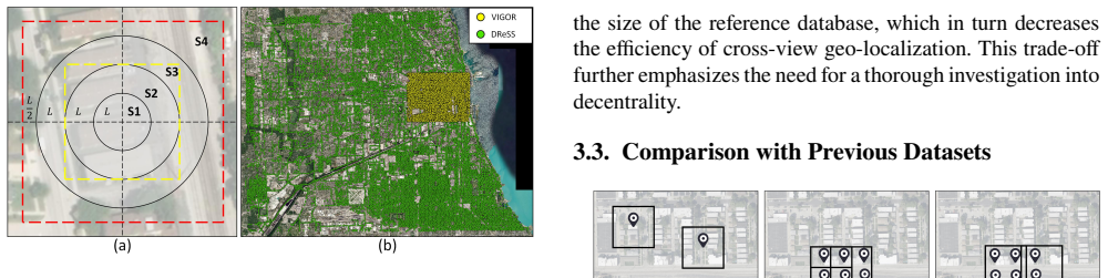
On the paper's own terms, the central discovery is that decentrality is a separable, measurable obstacle: retrieval accuracy collapses as query-to-center offset grows, and a training-only combination of a BEV intermediary and multi-grained position supervision recovers a meaningful part of that loss. The evidence is the DReSS dataset, where reference tiles overlap at 12.5% and the hit area is subdivided into four decentrality subsets; on those subsets Sample4Geo's R@1 falls from 72.74 (S1) to 35.49 (S4), while AuxGeo improves over it by 1.68, 1.76, 3.62, and 4.01 points respectively. AuxGeo also outperforms the same baseline on VIGOR, CVUSA, and CVACT, so the auxiliary tasks help in both offset and center-aligned regimes.
Load-bearing premise
The DReSS evaluation depends on assigning each street-view query to exactly one 'best-matched' aerial reference tile, but the paper does not specify how that assignment is made when multiple overlapping tiles cover a query location, so a noisy or biased assignment would distort every reported accuracy and method comparison.
Editorial extensions
If this is right
- On DReSS, AuxGeo raises R@1 over Sample4Geo by 3.30 points in SAME and 4.21 points in CROSS, and the per-subset gains grow with decentrality (1.68, 1.76, 3.62, and 4.01 points across S1-S4).
- AuxGeo also reaches the best reported results on VIGOR, CVUSA, and CVACT, so the auxiliary tasks do not trade away performance in center-aligned or modest-offset regimes.
- Because BIM and PCM are training-only, deployment of AuxGeo costs the same as the baseline backbone: one forward pass with global average pooling.
- Constructing reference databases at 12.5% overlap instead of 50% cuts the reference set by roughly a factor of 3.4, and the paper shows that methods must be decentrality-aware to benefit from that efficiency.
- The paper's own limitation is that accuracy under extremely high decentrality remains low, so decentrality-aware retrieval is improved but not solved.
Reading between the lines
- If the DReSS query-to-tile assignment is reproducible from public geo-tags, the dataset could become a standard stress test, letting future methods report accuracy per offset bin rather than one average.
- The training-only use of geometric priors suggests a general recipe: spatial supervision can be injected through auxiliary branches and discarded at inference, so a natural extension is applying BIM/PCM to drone-to-satellite or ground-to-map retrieval.
- Because PCM already regresses the query's position within the aerial tile, the same network could return a continuous location estimate alongside the retrieved tile, turning retrieval into coarse localization at no extra inference cost.
- The paper's efficiency argument implies practitioners could deliberately choose a low-overlap reference database and pay the accuracy cost only where the model cannot handle it; the paper does not provide a full Pareto curve of accuracy versus database size beyond the five overlap settings.
Signed reviews
Editorial analysis
A structured set of objections, weighed in public.
Referee Report
Summary. The paper introduces the 'decentrality' concept for cross-view geo-localization, defined as the offset between a street-view query and the center of its aerial reference image, and argues that existing datasets (CVUSA, CVACT, VIGOR) do not adequately cover large decentrality. It proposes DReSS, a new dataset of 174,934 street-view panoramas and 422,760 aerial images from eight cities, with a lower reference-tile overlap (12.5%) than VIGOR, and defines four decentrality subsets S1-S4. It also proposes AuxGeo, which adds two training-only auxiliary modules to a Sample4Geo baseline: a Bird's-eye view Intermediary Module (BIM) that uses BEV panoramas as an intermediate view, and a Position Constraint Module (PCM) that regresses query positions in aerial features at multiple scales. Experiments report SOTA or improved results on DReSS, VIGOR, CVUSA, and CVACT, with ablations showing contributions from both modules and no extra inference cost.
Significance. If the claims hold, the paper makes a useful contribution in two respects. First, DReSS would be the first public dataset specifically designed to stress-test cross-view geo-localization under large query-reference offsets, which is a realistic condition for pre-built reference databases. Second, AuxGeo demonstrates a credible recipe for using auxiliary signals (BEV transforms and position priors) at training time only, preserving inference efficiency. The paper's strengths include extensive comparisons across four datasets, ablations of both proposed modules, a generalization experiment across datasets, and the explicit promise of public code and data. The main caveat is that the central DReSS-based claims depend on a dataset construction protocol whose details are not yet fully specified.
major comments (5)
- [Section 3.1, Table 2] The ground-truth assignment rule for DReSS is under-specified. Section 3.1 defines the hit area conceptually but does not state how a unique 'best-matched' aerial reference tile is chosen when a query point falls inside multiple overlapping 224x224 tiles, which occurs at all overlap levels below 100%. Table 2 shows that at 12.5% overlap the S1-S4 pair counts sum to exactly 174,934 (the number of street-view queries), but at 20%, 30%, 40%, and 50% overlap the same sums are 175,170, 175,172, 175,184, and 175,183 respectively, exceeding the query count. This implies that some queries are assigned to more than one positive tile, or that the counting procedure differs across overlap levels. Without a deterministic, one-to-one, geometrically defined assignment of positives, R@1 in Tables 5-6 is not a well-defined retrieval metric, and the per-subset decentrality analysis may inherit an arbitrary labeling artifact. Please specify the exact assignment rule (e.g., nearest tile center, fixed tie-breaking, or all covering tiles treated as positives) and provide the code or a precise algorithm used to generate the ground-truth pairs.
- [Section 3.1, Figure 2(a)] The boundaries of the four decentrality subsets S1-S4 and of the hit area are defined only visually. The paper does not give the geographic coordinates, distance intervals, or overlap-based formulas used to assign each pair to S1, S2, S3, or S4, nor does it define what 'with no interaction' means quantitatively. This makes the central result in Table 6 -- the progressively larger improvement of AuxGeo over Sample4Geo from S1 to S4 -- irreproducible. Please provide the exact set of inequalities (e.g., in meters or in fractions of tile size) that determine subset membership, and state whether the subset definitions are applied to the query position relative to the tile center, the tile corners, or the hit-area boundary.
- [Tables 5-8 and Table 9] The paper reports no error bars, multiple seeds, or significance tests for any of the main retrieval numbers. This is particularly consequential for the DReSS results: on VIGOR the improvement over Sample4Geo is 2.48 R@1 in SAME and 2.24 in CROSS, while on CVUSA the improvement is 0.12 R@1, and on DReSS SAME the improvement is 3.30 R@1. Without variance estimates, the claim that AuxGeo 'progressively' improves with increasing decentrality (Table 6) rests on a single run. Please report at least 3 seeds with mean and standard deviation for all tables where a comparison is made, or provide a statistical test (e.g., paired bootstrap over queries) for the headline DReSS and VIGOR comparisons.
- [Section 5.2.2, Table 6] The experimental protocol for the decentrality analysis is ambiguous. The text says 'Models were trained using data with various degrees of decentrality and evaluated across Subsets 1 to 4', but it does not state whether the models are trained on the full DReSS training set (which contains all decentrality levels) or on subsets restricted to particular decentrality ranges, nor whether the same model checkpoint is used for all four subset columns. If the former, the phrase 'trained using data with various degrees' is misleading; if the latter, the experimental setup needs to be described in full, including how the training subsets were balanced and whether the hyperparameters were re-tuned. Please clarify and, if multiple training protocols were used, report results for each.
- [Section 3.5, Section 5.1.2] The Hit metric on DReSS reveals a discrepancy that interacts with the ground-truth issue: for Sample4Geo SAME, R@1 is 51.40 while Hit is 55.89, and for AuxGeo SAME, R@1 is 54.70 while Hit is 59.20. This means a substantial number of top-1 retrievals are being scored as errors even though the retrieved aerial tile contains the query location, because they do not match the single 'best-matched' tile. If the evaluation instead used the standard localization-based positive set (all tiles covering the query), the relative ranking of methods and the per-subset improvement pattern could change. Please report results under both definitions (one-positive-per-query and all-covering-tiles) and discuss whether the conclusions of Tables 5 and 6 are robust to the choice of positive set.
minor comments (7)
- [Section 3.4] The sentence 'The panoramas are North-aligned, and each has a resolution of 2048 x 1024 pixels' should specify whether 'North-aligned' refers to the center of the panorama or the full 360-degree field of view, since this affects the BEV transformation and the orientation of the aerial images.
- [Section 5.2] Typo in the first sentence: 'We comapre our AuxGeo' should be 'We compare our AuxGeo'.
- [Table 3] The table lists 'Austrilia' for CVACT; this should be 'Australia'. Additionally, the 'Regions' row for DReSS says 'Urban and suburban', but Section 3.4 and the conclusion mention urban, suburban, and rural areas; please reconcile.
- [Section 2.2.1] The citation 'Zhang et al. (Zhang and Zhu, 2024)' appears in the text but the reference list contains 'Zhang, Q., Zhu, Y., 2024' with title 'Aligning geometric spatial layout...'; the in-text citation format is inconsistent with the reference entry and should be checked.
- [Figure 5 and Section 4.2.1] Figure 5 is dense and the labels A1, A2, B are not explained in the caption. Please add a short caption description of the three panels, especially the data flow through BIM and PCM, to make the figure self-contained.
- [Section 4.2.4, Equation (4)] The loss notation uses the subscript/superscript convention _a^b inconsistently with the text: Equation (4) defines _street^aerial and _bev^street and _bev^aerial, but the text above refers to the InfoNCE loss in Equation (2) with different notation. Please standardize the subscript/ superscript convention.
- [Section 7] The conclusion states that 'DReSS comprises cross-view images from eight global cities, representing diverse styles and encompassing extensive regions, including urban, suburban, and rural areas', but Table 3 lists only 'Urban and suburban'. Please align the descriptions.
Circularity Check
No circular derivation: AuxGeo is validated on independent public benchmarks and its training-only modules are supervised by geometry, not fitted to the reported retrieval scores.
full rationale
The paper's central claims rest on comparisons on CVUSA, CVACT, VIGOR, and the new DReSS benchmark (Tables 5, 8). AuxGeo's modules are training-time auxiliary losses: BIM adds InfoNCE losses between street/BEV and aerial/BEV views (Eq. 4), and PCM supervises regressed positions with geo-tag-derived position priors (Eq. 3). These are standard contrastive/regression objectives, not parameters fitted to the retrieval numbers, so the reported R@1/Hit results are not forced by construction. The BEV transform is attributed to prior work (Wang et al., 2024) as a geometry-only operation, and no author-specific uniqueness theorem or ansatz is invoked to rule out alternatives. The manuscript's own Sec. 7 limitation statement acknowledges poor accuracy under extreme decentrality, consistent with an honest empirical finding rather than a circular one. The DReSS evaluation protocol (Sec. 3.1 and 3.5) is under-specified about how each street-view query is assigned its unique positive aerial tile, and Table 2's pair counts exceed the query count at 20%-50% overlap; this is a dataset-validity and reproducibility risk, but it is not a circularity because it does not make the method's outputs equivalent to its inputs. The only self-citations (e.g., Xia et al., 2024 in Sec. 2.2.2) are related-work mentions and carry no load-bearing argument.
Assumptions & free parameters
free parameters (4)
- loss weight λ1 (street-BEV) =
0.1
- loss weight λ2 (BEV-aerial) =
0.1
- loss weight λ3 (PCM) =
0.05
- reference image overlap ratio =
12.5%
assumptions (4)
- domain assumption The BEV transform of Wang et al. (2024) correctly converts street-view panoramas into bird's-eye views with a geometry-only mapping.
- domain assumption Street-view panoramas and aerial reference images are North-aligned, so position priors and the BEV transform are rotationally consistent.
- ad hoc to paper Each query has a single well-defined 'best-matched' aerial reference, and the hit-area boundaries used to define subsets S1-S4 are objective and reproducible.
- domain assumption The aerial images from Esri World Imagery at zoom level 18 are geographically accurate and of sufficient resolution for the retrieval task.
Cite this review
Pith. "Pith review of Cross-View Geo-Localization with Street-View and VHR Satellite Imagery in Decentrality Settings." pith.science (2026). https://pith.science/paper/YNGUFCV3
@misc{pith2026241211529,
  author       = {Pith},
  title        = {Pith review of: Cross-View Geo-Localization with Street-View and VHR Satellite Imagery in Decentrality Settings},
  year         = {2026},
  howpublished = {\url{https://pith.science/paper/YNGUFCV3}},
  note         = {Machine review of arXiv:2412.11529}
}
read the original abstract
Cross-View Geo-Localization tackles the challenge of image geo-localization in GNSS-denied environments, including disaster response scenarios, urban canyons, and dense forests, by matching street-view query images with geo-tagged aerial-view reference images. However, current research often relies on benchmarks and methods that assume center-aligned settings or account for only limited decentrality, which we define as the offset of the query image relative to the reference image center. Such assumptions fail to reflect real-world scenarios, where reference databases are typically pre-established without the possibility of ensuring perfect alignment for each query image. Moreover, decentrality is a critical factor warranting deeper investigation, as larger decentrality can substantially improve localization efficiency but comes at the cost of declines in localization accuracy. To address this limitation, we introduce DReSS (Decentrality Related Street-view and Satellite-view dataset), a novel dataset designed to evaluate cross-view geo-localization with a large geographic scope and diverse landscapes, emphasizing the decentrality issue. Meanwhile, we propose AuxGeo (Auxiliary Enhanced Geo-Localization) to further study the decentrality issue, which leverages a multi-metric optimization strategy with two novel modules: the Bird's-eye view Intermediary Module (BIM) and the Position Constraint Module (PCM). These modules improve the localization accuracy despite the decentrality problem. Extensive experiments demonstrate that AuxGeo outperforms previous methods on our proposed DReSS dataset, mitigating the issue of large decentrality, and also achieves state-of-the-art performance on existing public datasets such as CVUSA, CVACT, and VIGOR.
Figures


Figures from the paper (5 more)


Forward citations
Cited by 1 Pith paper
-
Cross-View Localization via Redundant Sliced Observations and A-Contrario Validation
Slice-Loc divides panoramic query images into slices, estimates each slice's 3-DoF pose, and uses an a-contrario false-alarm model to reject unreliable localizations, cutting DReSS cross-area mean error from 4.47 m to 1.86 m.
Reference graph
Works this paper leans on
-
[1]
write newline
" write newline "" before.all 'output.state := FUNCTION n.dashify 't := "" t empty not t #1 #1 substring "-" = t #1 #2 substring "--" = not "--" * t #2 global.max substring 't := t #1 #1 substring "-" = "-" * t #2 global.max substring 't := while if t #1 #1 substring * t #2 global.max substring 't := if while FUNCTION word.in bbl.in ":" * " " * FUNCTION f...
-
[2]
author Cheng, L. , author Yuan, Y. , author Xia, N. , author Chen, S. , author Chen, Y. , author Yang, K. , author Ma, L. , author Li, M. , year 2018 . title Crowd-sourced pictures geo-localization method based on street view images and 3d reconstruction . journal ISPRS journal of photogrammetry and remote sensing volume 141 , pages 72--85
work page 2018
-
[3]
author Chiu, H.P. , author Murali, V. , author Villamil, R. , author Kessler, G.D. , author Samarasekera, S. , author Kumar, R. , year 2018 . title Augmented reality driving using semantic geo-registration , in: booktitle 2018 IEEE Conference on Virtual Reality and 3D User Interfaces (VR) , organization IEEE . pp. pages 423--430
work page 2018
-
[4]
author Deuser, F. , author Habel, K. , author Oswald, N. , year 2023 . title Sample4geo: Hard negative sampling for cross-view geo-localisation , in: booktitle Proceedings of the IEEE/CVF International Conference on Computer Vision , pp. pages 16847--16856
work page 2023
-
[5]
author Elhashash, M. , author Qin, R. , year 2022 . title Cross-view slam solver: Global pose estimation of monocular ground-level video frames for 3d reconstruction using a reference 3d model from satellite images . journal ISPRS Journal of Photogrammetry and Remote Sensing volume 188 , pages 62--74
work page 2022
-
[6]
author Esri , year 2024 . title Esri world imagery . howpublished https://www.arcgis.com/home/item.html?id=10df2279f9684e4a9f6a7f08febac2a9
work page 2024
-
[7]
author H \"a ne, C. , author Heng, L. , author Lee, G.H. , author Fraundorfer, F. , author Furgale, P. , author Sattler, T. , author Pollefeys, M. , year 2017 . title 3d visual perception for self-driving cars using a multi-camera system: Calibration, mapping, localization, and obstacle detection . journal Image and Vision Computing volume 68 , pages 14--27
work page 2017
-
[8]
author He, Y. , author Ye, D. , author Tang, L. , author Liu, Z. , author Chen, C. , year 2024 . title Advlut: Cloaking geographic location with semantic-based adversarial 3d lookup tables . journal IEEE Internet of Things Journal
work page 2024
Show all 49 references
-
[9]
, author Feng, M
author Hu, S. , author Feng, M. , author Nguyen, R.M. , author Lee, G.H. , year 2018 . title Cvm-net: Cross-view matching network for image-based ground-to-aerial geo-localization , in: booktitle Proceedings of the IEEE Conference on Computer Vision and Pattern Recognition , p...
2018
-
[10]
, author Zhou, Y
author Huang, G. , author Zhou, Y. , author Zhao, L. , author Gan, W. , year 2024 . title Cv-cities: Advancing cross-view geo-localization in global cities . journal IEEE Journal of Selected Topics in Applied Earth Observations and Remote Sensing
2024
-
[11]
, author Walter, M.R
author Kim, D.K. , author Walter, M.R. , year 2017 . title Satellite image-based localization via learned embeddings , in: booktitle 2017 IEEE international conference on robotics and automation (ICRA) , organization IEEE . pp. pages 2073--2080
2017
-
[12]
, author Qian, M
author Li, G. , author Qian, M. , author Xia, G.S. , year 2024 a. title Unleashing unlabeled data: A paradigm for cross-view geo-localization , in: booktitle Proceedings of the IEEE/CVF Conference on Computer Vision and Pattern Recognition , pp. pages 16719--16729
2024
-
[13]
, author Deuser, F
author Li, H. , author Deuser, F. , author Yina, W. , author Luo, X. , author Walther, P. , author Mai, G. , author Huang, W. , author Werner, M. , year 2024 b. title Cross-view geolocalization and disaster mapping with street-view and vhr satellite imagery: A case study of hu...
2024 arXiv
-
[14]
, author Xu, C
author Li, H. , author Xu, C. , author Yang, W. , author Yu, H. , author Xia, G.S. , year 2024 c. title Learning cross-view visual geo-localization without ground truth . arXiv:2403.12702 http://arxiv.org/abs/2403.12702
2024 arXiv
-
[15]
, author Lai, Y
author Li, W. , author Lai, Y. , author Xu, L. , author Xiangli, Y. , author Yu, J. , author He, C. , author Xia, G.S. , author Lin, D. , year 2023 . title Omnicity: Omnipotent city understanding with multi-level and multi-view images , in: booktitle Proceedings of the IEEE/CV...
2023
-
[16]
, author Belongie, S
author Lin, T.Y. , author Belongie, S. , author Hays, J. , year 2013 . title Cross-view image geolocalization , in: booktitle Proceedings of the IEEE Conference on Computer Vision and Pattern Recognition , pp. pages 891--898
2013
-
[17]
, author Qin, R
author Ling, X. , author Qin, R. , year 2022 . title A graph-matching approach for cross-view registration of over-view and street-view based point clouds . journal ISPRS Journal of Photogrammetry and Remote Sensing volume 185 , pages 2--15
2022
-
[18]
, author Li, H
author Liu, L. , author Li, H. , year 2019 . title Lending orientation to neural networks for cross-view geo-localization , in: booktitle Proceedings of the IEEE/CVF conference on computer vision and pattern recognition , pp. pages 5624--5633
2019
-
[19]
, author Mao, H
author Liu, Z. , author Mao, H. , author Wu, C.Y. , author Feichtenhofer, C. , author Darrell, T. , author Xie, S. , year 2022 . title A convnet for the 2020s , in: booktitle Proceedings of the IEEE/CVF conference on computer vision and pattern recognition , pp. pages 11976--11986
2022
-
[20]
, author Li, Z
author Lu, X. , author Li, Z. , author Cui, Z. , author Oswald, M.R. , author Pollefeys, M. , author Qin, R. , year 2020 . title Geometry-aware satellite-to-ground image synthesis for urban areas , in: booktitle Proceedings of the IEEE/CVF Conference on Computer Vision and Pat...
2020
-
[21]
, author Churchill, W
author McManus, C. , author Churchill, W. , author Maddern, W. , author Stewart, A.D. , author Newman, P. , year 2014 . title Shady dealings: Robust, long-term visual localisation using illumination invariance , in: booktitle 2014 IEEE international conference on robotics and ...
2014
-
[22]
, author Borji, A
author Regmi, K. , author Borji, A. , year 2018 . title Cross-view image synthesis using conditional gans , in: booktitle Proceedings of the IEEE conference on Computer Vision and Pattern Recognition , pp. pages 3501--3510
2018
-
[23]
, author Shah, M
author Regmi, K. , author Shah, M. , year 2019 . title Bridging the domain gap for ground-to-aerial image matching , in: booktitle Proceedings of the IEEE/CVF International Conference on Computer Vision , pp. pages 470--479
2019
-
[24]
, author Campbell, D
author Shi, Y. , author Campbell, D. , author Yu, X. , author Li, H. , year 2022 . title Geometry-guided street-view panorama synthesis from satellite imagery . journal IEEE Transactions on Pattern Analysis and Machine Intelligence volume 44 , pages 10009--10022
2022
-
[25]
, author Liu, L
author Shi, Y. , author Liu, L. , author Yu, X. , author Li, H. , year 2019 . title Spatial-aware feature aggregation for image based cross-view geo-localization . journal Advances in Neural Information Processing Systems volume 32
2019
-
[26]
, author Yu, X
author Shi, Y. , author Yu, X. , author Campbell, D. , author Li, H. , year 2020 a. title Where am i looking at? joint location and orientation estimation by cross-view matching , in: booktitle Proceedings of the IEEE/CVF Conference on Computer Vision and Pattern Recognition ,...
2020
-
[27]
, author Yu, X
author Shi, Y. , author Yu, X. , author Liu, L. , author Zhang, T. , author Li, H. , year 2020 b. title Optimal feature transport for cross-view image geo-localization , in: booktitle Proceedings of the AAAI Conference on Artificial Intelligence , pp. pages 11990--11997
2020
-
[28]
, author Chen, C
author Sun, B. , author Chen, C. , author Zhu, Y. , author Jiang, J. , year 2019 . title Geocapsnet: Ground to aerial view image geo-localization using capsule network , in: booktitle 2019 IEEE International Conference on Multimedia and Expo (ICME) , organization IEEE . pp. pa...
2019
-
[29]
, author Chen, C
author Tian, Y. , author Chen, C. , author Shah, M. , year 2017 . title Cross-view image matching for geo-localization in urban environments , in: booktitle Proceedings of the IEEE Conference on Computer Vision and Pattern Recognition , pp. pages 3608--3616
2017
-
[30]
, author Zhou, Q
author Toker, A. , author Zhou, Q. , author Maximov, M. , author Leal-Taix \'e , L. , year 2021 . title Coming down to earth: Satellite-to-street view synthesis for geo-localization , in: booktitle Proceedings of the IEEE/CVF Conference on Computer Vision and Pattern Recogniti...
2021
-
[31]
, author Hays, J
author Vo, N.N. , author Hays, J. , year 2016 . title Localizing and orienting street views using overhead imagery , in: booktitle Computer Vision--ECCV 2016: 14th European Conference, Amsterdam, The Netherlands, October 11--14, 2016, Proceedings, Part I 14 , organization Spri...
2016
-
[32]
, author Liu, J
author Wan, X. , author Liu, J. , author Yan, H. , author Morgan, G.L. , year 2016 . title Illumination-invariant image matching for autonomous uav localisation based on optical sensing . journal ISPRS Journal of Photogrammetry and Remote Sensing volume 119 , pages 198--213
2016
-
[33]
, author Li, J
author Wang, T. , author Li, J. , author Sun, C. , year 2023 . title Dehi: A decoupled hierarchical architecture for unaligned ground-to-aerial geo-localization . journal IEEE Transactions on Circuits and Systems for Video Technology
2023
-
[34]
, author Xu, R
author Wang, X. , author Xu, R. , author Cui, Z. , author Wan, Z. , author Zhang, Y. , year 2024 . title Fine-grained cross-view geo-localization using a correlation-aware homography estimator . journal Advances in Neural Information Processing Systems volume 36
2024
-
[35]
, author Souvenir, R
author Workman, S. , author Souvenir, R. , author Jacobs, N. , year 2015 . title Wide-area image geolocalization with aerial reference imagery , in: booktitle Proceedings of the IEEE International Conference on Computer Vision , pp. pages 3961--3969
2015
-
[36]
, author Wan, Y
author Wu, Q. , author Wan, Y. , author Zheng, Z. , author Zhang, Y. , author Wang, G. , author Zhao, Z. , year 2024 . title Camp: A cross-view geo-localization method using contrastive attributes mining and position-aware partitioning . journal IEEE Transactions on Geoscience...
2024
-
[37]
, author Wan, Y
author Xia, P. , author Wan, Y. , author Zheng, Z. , author Zhang, Y. , author Deng, J. , year 2024 . title Enhancing cross-view geo-localization with domain alignment and scene consistency . journal IEEE Transactions on Circuits and Systems for Video Technology
2024
-
[38]
, author Lu, X
author Yang, H. , author Lu, X. , author Zhu, Y. , year 2021 . title Cross-view geo-localization with layer-to-layer transformer . journal Advances in Neural Information Processing Systems volume 34 , pages 29009--29020
2021
-
[39]
, author Luo, Q
author Ye, J. , author Luo, Q. , author Yu, J. , author Zhong, H. , author Zheng, Z. , author He, C. , author Li, W. , year 2024 a. title Sg-bev: Satellite-guided bev fusion for cross-view semantic segmentation , in: booktitle Proceedings of the IEEE/CVF Conference on Computer...
2024
-
[40]
, author Lv, Z
author Ye, J. , author Lv, Z. , author Li, W. , author Yu, J. , author Yang, H. , author Zhong, H. , author He, C. , year 2025 . title Cross-view image geo-localization with panorama-bev co-retrieval network , in: booktitle European Conference on Computer Vision , organization...
2025
-
[41]
, author Luo, J
author Ye, Q. , author Luo, J. , author Lin, Y. , year 2024 b. title A coarse-to-fine visual geo-localization method for gnss-denied uav with oblique-view imagery . journal ISPRS Journal of Photogrammetry and Remote Sensing volume 212 , pages 306--322
2024
-
[42]
, author Bessinger, Z
author Zhai, M. , author Bessinger, Z. , author Workman, S. , author Jacobs, N. , year 2017 . title Predicting ground-level scene layout from aerial imagery , in: booktitle Proceedings of the IEEE Conference on Computer Vision and Pattern Recognition , pp. pages 867--875
2017
-
[43]
, author Zhu, Y
author Zhang, Q. , author Zhu, Y. , year 2024 . title Aligning geometric spatial layout in cross-view geo-localization via feature recombination , in: booktitle Proceedings of the AAAI Conference on Artificial Intelligence , pp. pages 7251--7259
2024
-
[44]
, author Li, X
author Zhang, X. , author Li, X. , author Sultani, W. , author Zhou, Y. , author Wshah, S. , year 2023 . title Cross-view geo-localization via learning disentangled geometric layout correspondence , in: booktitle Proceedings of the AAAI Conference on Artificial Intelligence , ...
2023
-
[45]
, author Wei, Y
author Zheng, Z. , author Wei, Y. , author Yang, Y. , year 2020 . title University-1652: A multi-view multi-source benchmark for drone-based geo-localization , in: booktitle Proceedings of the 28th ACM international conference on Multimedia , pp. pages 1395--1403
2020
-
[46]
, author Shah, M
author Zhu, S. , author Shah, M. , author Chen, C. , year 2022 . title Transgeo: Transformer is all you need for cross-view image geo-localization , in: booktitle Proceedings of the IEEE/CVF Conference on Computer Vision and Pattern Recognition , pp. pages 1162--1171
2022
-
[47]
, author Yang, T
author Zhu, S. , author Yang, T. , author Chen, C. , year 2021 . title Vigor: Cross-view image geo-localization beyond one-to-one retrieval , in: booktitle Proceedings of the IEEE/CVF Conference on Computer Vision and Pattern Recognition , pp. pages 3640--3649
2021
-
[48]
, author Yang, H
author Zhu, Y. , author Yang, H. , author Lu, Y. , author Huang, Q. , year 2023 . title Simple, effective and general: A new backbone for cross-view image geo-localization . arXiv:2302.01572 http://arxiv.org/abs/2302.01572
2023 arXiv
-
[49]
write newline
" write newline "" before.all 'output.state := FUNCTION n.dashify 't := "" t empty not t #1 #1 substring "-" = t #1 #2 substring "--" = not "--" * t #2 global.max substring 't := t #1 #1 substring "-" = "-" * t #2 global.max substring 't := while if t #1 #1 substring * t #2 gl...
Reviewed August 11, 2026 · model on record in the stance chip above.
Discussion (0). Continue with ORCID to comment.