REVIEW 4 major objections 7 minor 63 references
LDPoly: Latent Diffusion for Polygonal Road Outline Extraction in Large-Scale Topographic Mapping
T0 review · 4 major / 7 minor · reviewed 2026-08-16 · deepseek-v4-flash
Pith's one-line read A dual-latent diffusion model that jointly generates road masks and vertex heatmaps can extract vectorized road polygons from aerial images, outperforming seven baselines on a Dutch topographic benchmark and generalizing to unseen regions.
desk verdict A genuine first for polygonal road outline extraction with a sensible diffusion pipeline and honest ablations; the main risk is an unmeasured autoencoder assumption and missing reproducibility artifacts. read the letter →
The pith
A machine-rendered reading of the paper's core claim, the machinery that carries it, and where it could break.
The reading
What carries the argument
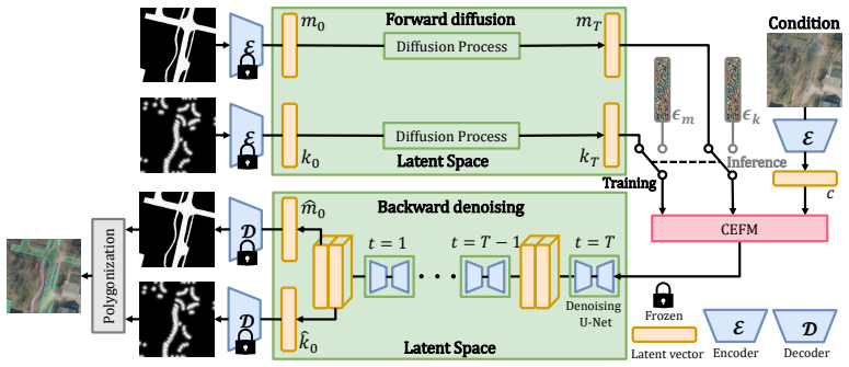
The load-bearing mechanism is a dual-latent diffusion model: two targets, a road mask and a vertex heatmap, are encoded into the latent space of a frozen Stable Diffusion autoencoder, corrupted with Gaussian noise, and denoised together by a UNet conditioned on the aerial image. The Channel-Embedded Fusion Module adds learnable channel embeddings to each projected latent feature before concatenation, so the two denoising objectives can exchange information without being confused. The accompanying polygonizer traces the predicted mask contour, keeps contour points near heatmap-extracted keypoints, and reinserts Douglas-Peucker-detected inflection points to preserve narrow alley junctions. The frozen autoencoder is what makes the whole latent-space operation possible, and the paper asserts without quantitative verification that it reconstructs precise masks and heatmaps.
What would settle it
Measure the reconstruction fidelity of the frozen autoencoder on Map2ImLas: encode ground-truth road masks and vertex heatmaps with E, decode with D, and compare mask IoU and vertex detection recall between the originals and the reconstructions. If the decoded masks already lose thin alleys or traffic-island holes, or vertices shift by more than a few pixels, the latent-space premise fails and downstream polygons inherit distortions no polygonizer can undo.
Extended reading notes
Core claim
On its own terms, the paper's central discovery is that a dual-latent conditional diffusion model can replace the usual segmentation-plus-vectorization pipeline for road polygons. The model denoises two targets at once, a binary road mask and a Gaussian vertex heatmap, in the frozen latent space of a pretrained Stable Diffusion autoencoder, with a Channel-Embedded Fusion Module letting the image condition, mask, and heatmap features interact. A custom polygonizer then traces the mask contour, selects vertices using non-maximum suppression on the heatmap, filters them by distance, and re-inserts near-right-angle inflection points found by Douglas-Peucker. The reported outcome is that generated polygons are smoother, more topologically connected, and use fewer redundant vertices than those from seven baselines, including on unseen Dutch regions, with the largest gaps appearing in vertex precision and recall.
Load-bearing premise
The frozen Stable Diffusion autoencoder can encode and decode binary road masks and vertex heatmaps without losing the fine corners and closely spaced vertices that the polygonizer needs.
Editorial extensions
If this is right
- If the dual-latent design is correct, diffusion models can produce precise vectorized object outlines, not just raster labels, in remote-sensing imagery.
- Jointly generating the mask and vertex heatmap sharply improves vertex localization over a non-diffusion baseline, with reported precision rising from 26.0 to 79.8 and recall from 70.6 to 75.4.
- The proposed polygonizer preserves pixel-level coverage while reducing vertex redundancy, whereas direct Douglas-Peucker vectorization keeps high IoU but produces excessive vertices.
- Cross-region results suggest a model trained on one Dutch region can generalize to unseen urban, suburban, and rural regions, with degradation mainly when the visual domain shifts strongly.
- The new S-IoU metric can evaluate polygon simplicity using dataset-level vertex statistics, making it usable in annotation-limited settings.
Reading between the lines
- The same dual-latent recipe could be extended to other topographic polygon classes such as buildings, water, and vegetation, since Map2ImLas contains those annotations, though the paper only evaluates roads.
- Because the frozen-autoencoder reconstruction premise is unquantified, a natural test is to fine-tune the autoencoder on masks and heatmaps; if that improves vertex recall, the paper's latent-space premise is only partially responsible for its results.
- The reference-free S-IoU idea could support semi-supervised topographic mapping by scoring predicted polygons in unlabeled regions against dataset-level vertex statistics rather than ground-truth contours.
Signed reviews
Editorial analysis
A structured set of objections, weighed in public.
Referee Report
Summary. The paper introduces LDPoly, a conditional latent diffusion framework for extracting polygonal road outlines from high-resolution aerial images. The method encodes road masks and vertex heatmaps into the latent space of a frozen Stable Diffusion autoencoder, jointly denoises the two latents with a U-Net augmented by a Channel-Embedded Fusion Module, and then converts the decoded mask and heatmap into vector polygons via a four-stage polygonization procedure. The authors introduce a new Dutch topographic dataset, Map2ImLas, and two new metrics, S-IoU and SCR. They report experiments on Deventer (in-region) and Enschede and Giethoorn (cross-region), comparing with seven baselines and showing consistent gains in vertex efficiency, polygon regularity, and connectivity.
Significance. If the results hold up, this is a useful first dedicated framework for polygonal road outline extraction, a task distinct from road segmentation, road centerline extraction, and building polygon extraction. The dual-latent diffusion design, the channel-embedding fusion idea, the cross-region evaluation protocol, and the new benchmark are all potentially valuable contributions to topographic mapping and remote-sensing vision. The paper also merits credit for extensive ablations that isolate the diffusion process, the fusion module, and the polygonization algorithm. However, the central claim is weakened by missing validation of the frozen autoencoder premise, the absence of any run-to-run variance or statistical significance reporting, and an inconsistency in the definition of the new S-IoU metric. Code, weights, and the Map2ImLas dataset are not available at submission, so the results cannot currently be independently reproduced.
major comments (4)
- [Section 4.1, Eq. (6)-(7)] The paper asserts, without quantitative support, that the frozen pretrained Stable Diffusion autoencoder reconstructs precise road masks and vertex heatmaps. This premise is load-bearing because the polygonization algorithm selects vertices along the decoded mask contour and uses the decoded heatmap only as guidance; any encode-decode distortion is inherited by the final polygon and cannot be corrected downstream. The manuscript reports no reconstruction IoU, boundary error, or vertex localization error, and it does not compare against a fine-tuned or purpose-trained autoencoder. Given the 8x downsampling and the thin, narrow structures present in road networks, such an experiment is necessary to support Eq. (7) and to attribute the gains in Tables 1-3 to the diffusion framework itself.
- [Section 5.2, Eq. (20)] The definition of the simplicity factor SF is internally inconsistent. As written, SF(N_hat m) = sum_i (1+e^{k(3-N_i_sigma)})/(1+e^{k(N_hat m - N_i_sigma)}). At N_hat m = 3 this evaluates to 3, contradicting the statement that "SF reaches its maximum value of 1" and the y-axis range in Figure 6. If the intended final SF is the mean of the three SFi_sigma terms, Eq. (20) is missing a factor of 1/3; if the sum was intended, S-IoU is not normalized to [0,1]. Because S-IoU is a headline metric in Tables 1-3, the formula must be corrected and the reported S-IoU values recomputed or confirmed.
- [Section 5.3, Tables 1-3] All comparisons are based on single runs with no reported variance, confidence intervals, or paired statistical tests. This is especially important because diffusion inference is stochastic and because several reported advantages over the second-best method are modest (e.g., Deventer IoU 75.0 vs. 71.5, APLS 68.9 vs. 65.6; Giethoorn APLS 71.1 vs. 71.4 for CoANet). Without multiple seeds and appropriate significance testing, the claim that LDPoly "outperforms state-of-the-art polygon extraction methods across various metrics" is not yet established for the smaller-margin differences.
- [Section 5.2 and Section 4.4] The S-IoU thresholds N1_sigma, N2_sigma, and N3_sigma are fitted to the vertex-count distribution of the Map2ImLas dataset and then used to score predictions on that same dataset, with no sensitivity analysis for the decay rate k or the threshold values. The polygonization thresholds dth, the heatmap NMS threshold, the Gaussian sigma, and the inflection-angle threshold tau are likewise fixed without sensitivity analysis even though they directly control vertex count and therefore influence N-ratio, C-IoU, and S-IoU. The authors should report how results vary with these thresholds and justify that the reported ranking is not an artifact of threshold selection.
minor comments (7)
- [Section 5.2] The APLS metric name is misspelled as "Average Pah Length Similarity"; it should be "Average Path Length Similarity." The table headers also contain a stray "1" ("APLS ↑1").
- [Section 4.2] The text says "Gaussian nosie" and "nosie" several times; the intended word is "noise."
- [Table 1] The DeepLabV3+ APLS value is printed as "56,4" with a comma decimal separator, while the rest of the paper uses periods; please standardize.
- [Section 4.4, Eq. (17)] The set-builder notation is malformed: V_inflection is written as an expression rather than as the intended set construction { v in C_hat | 90° - tau <= theta(v) <= 90° + tau }.
- [Section 5.3] The stitched evaluation in Figure 10 is described only qualitatively. Please clarify whether the tables report per-patch metrics, stitched-image metrics, or both, and how vertices are aggregated across patch boundaries without introducing discontinuities.
- [Section 1] The novelty claims are appropriately scoped, but the phrase "state-of-the-art polygon extraction methods" is based on a comparison set of building-polygon and segmentation baselines; recent HD-map reconstruction methods such as MapTR are mentioned in related work but not compared. A sentence explicitly stating why these methods are not applicable would strengthen the comparison.
- [Section 5.1] The release of code, weights, and the processed dataset is deferred until acceptance, and the Map2ImLas dataset is described as under review elsewhere. For a paper introducing a new benchmark, a description of the annotation process, the license, and a committed release timeline would materially improve reproducibility.
Circularity Check
No self-definitional or fitted-input circularity; unvalidated autoencoder premise and metric calibration are validation concerns, not derivation circularity.
full rationale
I examined the derivation chain for self-definition, fitted-input prediction, and load-bearing self-citation. LDPoly is trained with a standard conditional diffusion objective (Eq. 13) on rasterized road masks and Gaussian vertex heatmaps derived from vector annotations; at inference it denoises latent noise and polygonizes the decoded mask and heatmap. The outputs are therefore not algebraically forced by the training targets. The only asserted premise lacking direct evidence is Eq. (7), where the frozen Stable Diffusion autoencoder is assumed to reconstruct masks and heatmaps precisely; this is an unvalidated architectural assumption (no reconstruction IoU or vertex error is reported), but it is not circular because the premise is not derived from the conclusion. The S-IoU thresholds N1σ, N2σ, N3σ are fitted to the vertex-count distribution of Map2ImLas and then used to reward simplified polygons (Eqs. 19-20); this is a metric-calibration concern and can advantage vertex-reducing polygonization, but LDPoly is not trained to optimize S-IoU and its IoU, B-IoU, PoLiS, and APLS advantages are reported independently. Self-citations (Refs. 34, 36) appear only as related-work references to the authors' prior building-outline methods and do not carry the central argument. I therefore find no circular step under the stated criteria.
Assumptions & free parameters
free parameters (6)
- Vertex heatmap Gaussian standard deviation =
5 pixels
- Polygonization distance threshold dth =
not reported
- Retained inflection angle threshold tau =
30 degrees
- S-IoU simplicity factor thresholds N1σ, N2σ, N3σ and decay rate k =
derived from log-normal fit to Map2ImLas vertex counts; k = 0.1
- Loss coefficients lambda_mt, lambda_kt, lambda_m0, lambda_k0 =
all set to 1
- NMS threshold for vertex heatmap extraction =
not reported
assumptions (5)
- standard math Gaussian posterior and noise schedule of DDPM, Eq. (1)-(3), correctly model the denoising process.
- domain assumption BGT road polygon definition, including internal holes and mixed road surfaces, is the correct and complete target representation.
- domain assumption The pretrained Stable Diffusion autoencoder reconstructs binary masks and Gaussian heatmaps with sufficient fidelity without fine-tuning.
- ad hoc to paper A binary road mask plus a vertex heatmap with Gaussian spread sigma=5 contains enough information to reconstruct all road polygon geometry, including narrow junctions.
- domain assumption DDIM sampling converges to the learned data distribution for these low-dimensional latents in a feasible number of steps.
Cite this review
Pith. "Pith review of LDPoly: Latent Diffusion for Polygonal Road Outline Extraction in Large-Scale Topographic Mapping." pith.science (2026). https://pith.science/paper/EX5KDHLF
@misc{pith2026250420645,
  author       = {Pith},
  title        = {Pith review of: LDPoly: Latent Diffusion for Polygonal Road Outline Extraction in Large-Scale Topographic Mapping},
  year         = {2026},
  howpublished = {\url{https://pith.science/paper/EX5KDHLF}},
  note         = {Machine review of arXiv:2504.20645}
}
read the original abstract
Polygonal road outline extraction from high-resolution aerial images is an important task in large-scale topographic mapping, where roads are represented as vectorized polygons, capturing essential geometric features with minimal vertex redundancy. Despite its importance, no existing method has been explicitly designed for this task. While polygonal building outline extraction has been extensively studied, the unique characteristics of roads, such as branching structures and topological connectivity, pose challenges to these methods. To address this gap, we introduce LDPoly, the first dedicated framework for extracting polygonal road outlines from high-resolution aerial images. Our method leverages a novel Dual-Latent Diffusion Model with a Channel-Embedded Fusion Module, enabling the model to simultaneously generate road masks and vertex heatmaps. A tailored polygonization method is then applied to obtain accurate vectorized road polygons with minimal vertex redundancy. We evaluate LDPoly on a new benchmark dataset, Map2ImLas, which contains detailed polygonal annotations for various topographic objects in several Dutch regions. Our experiments include both in-region and cross-region evaluations, with the latter designed to assess the model's generalization performance on unseen regions. Quantitative and qualitative results demonstrate that LDPoly outperforms state-of-the-art polygon extraction methods across various metrics, including pixel-level coverage, vertex efficiency, polygon regularity, and road connectivity. We also design two new metrics to assess polygon simplicity and boundary smoothness. Moreover, this work represents the first application of diffusion models for extracting precise vectorized object outlines without redundant vertices from remote-sensing imagery, paving the way for future advancements in this field.
Figures


Figures from the paper (15 more)


Reference graph
Works this paper leans on
-
[1]
A. Kent, Topographic maps: methodological approaches for analyzing cartographic style, Journal of Map & Geography Libraries 5 (2) (2009) 131–156
work page 2009
-
[2]
S. Oude Elberink, Acquisition of 3d topgraphy: automated 3d road and building reconstruction using airborne laser scanner data and topo- graphic maps (2010)
work page 2010
-
[3]
J. H¨ ohle, Generating topographic map data from classification results, Remote Sensing 9 (3) (2017) 224
work page 2017
-
[4]
Z. Chen, L. Deng, Y. Luo, D. Li, J. M. Junior, W. N. Gon¸ calves, A. A. M. Nurunnabi, J. Li, C. Wang, D. Li, Road extraction in remote sensing data: A survey, International journal of applied earth observation and geoinformation 112 (2022) 102833
work page 2022
-
[5]
URL https://docs.geostandaarden.nl/imgeo/catalogus/bgt/
Geonovum, Basisregistratie grootschalige topografie gegevenscatalogus bgt 1.2, accessed: 2025-04-02 (2020). URL https://docs.geostandaarden.nl/imgeo/catalogus/bgt/
work page 2020
-
[6]
A. Buslaev, S. Seferbekov, V. Iglovikov, A. Shvets, Fully convolutional network for automatic road extraction from satellite imagery, in: Pro- ceedings of the IEEE conference on computer vision and pattern recog- nition workshops, 2018, pp. 207–210
work page 2018
-
[7]
A. Chaurasia, E. Culurciello, Linknet: Exploiting encoder representa- tions for efficient semantic segmentation, in: 2017 IEEE visual commu- nications and image processing (VCIP), IEEE, 2017, pp. 1–4
work page 2017
-
[8]
L. Zhou, C. Zhang, M. Wu, D-linknet: Linknet with pretrained encoder and dilated convolution for high resolution satellite imagery road extrac- tion, in: Proceedings of the IEEE conference on computer vision and pattern recognition workshops, 2018, pp. 182–186. 43
work page 2018
Show all 63 references
-
[9]
Mei, R.-J
J. Mei, R.-J. Li, W. Gao, M.-M. Cheng, Coanet: Connectivity attention network for road extraction from satellite imagery, IEEE Transactions on Image Processing 30 (2021) 8540–8552
2021
-
[10]
Z. Yang, D. Zhou, Y. Yang, J. Zhang, Z. Chen, Transroadnet: A novel road extraction method for remote sensing images via combining high- level semantic feature and context, IEEE Geoscience and Remote Sens- ing Letters 19 (2022) 1–5
2022
-
[11]
M. Zhou, H. Sui, S. Chen, J. Wang, X. Chen, Bt-roadnet: A boundary and topologically-aware neural network for road extraction from high- resolution remote sensing imagery, ISPRS Journal of Photogrammetry and Remote Sensing 168 (2020) 288–306
2020
-
[12]
J. Chen, Y. Lu, Q. Yu, X. Luo, E. Adeli, Y. Wang, L. Lu, A. L. Yuille, Y. Zhou, Transunet: Transformers make strong encoders for medical image segmentation, arXiv preprint arXiv:2102.04306 (2021)
2021 arXiv
-
[13]
Jiang, Y
X. Jiang, Y. Li, T. Jiang, J. Xie, Y. Wu, Q. Cai, J. Jiang, J. Xu, H. Zhang, Roadformer: Pyramidal deformable vision transformers for road network extraction with remote sensing images, International Journal of Applied Earth Observation and Geoinformation 113 (2022) 102987
2022
-
[14]
Z. Chen, Y. Luo, J. Wang, J. Li, C. Wang, D. Li, Dpenet: Dual-path extraction network based on cnn and transformer for accurate building and road extraction, International Journal of Applied Earth Observation and Geoinformation 124 (2023) 103510
2023
-
[15]
H. Liu, C. Wang, J. Zhao, S. Chen, H. Kong, Adaptive fourier convo- lution network for road segmentation in remote sensing images, IEEE Transactions on Geoscience and Remote Sensing (2024)
2024
-
[16]
M´ attyus, W
G. M´ attyus, W. Luo, R. Urtasun, Deeproadmapper: Extracting road topology from aerial images, in: Proceedings of the IEEE international conference on computer vision, 2017, pp. 3438–3446
2017
-
[17]
Batra, S
A. Batra, S. Singh, G. Pang, S. Basu, C. Jawahar, M. Paluri, Improved road connectivity by joint learning of orientation and segmentation, in: Proceedings of the IEEE/CVF Conference on Computer Vision and Pat- tern Recognition, 2019, pp. 10385–10393. 44
2019
-
[18]
Z. Li, J. D. Wegner, A. Lucchi, Topological map extraction from over- head images, in: Proceedings of the IEEE/CVF International Confer- ence on Computer Vision, 2019, pp. 1715–1724
2019
-
[19]
Bastani, S
F. Bastani, S. He, S. Abbar, M. Alizadeh, H. Balakrishnan, S. Chawla, S. Madden, D. DeWitt, Roadtracer: Automatic extraction of road net- works from aerial images, in: Proceedings of the IEEE conference on computer vision and pattern recognition, 2018, pp. 4720–4728
2018
-
[20]
S. He, F. Bastani, S. Jagwani, M. Alizadeh, H. Balakrishnan, S. Chawla, M. M. Elshrif, S. Madden, M. A. Sadeghi, Sat2graph: Road graph ex- traction through graph-tensor encoding, in: Computer Vision–ECCV 2020: 16th European Conference, Glasgow, UK, August 23–28, 2020, Proceedi...
2020
-
[21]
Z. Xu, Y. Liu, L. Gan, Y. Sun, X. Wu, M. Liu, L. Wang, Rngdet: Road network graph detection by transformer in aerial images, IEEE Transactions on Geoscience and Remote Sensing 60 (2022) 1–12
2022
-
[22]
Z. Xu, Y. Liu, Y. Sun, M. Liu, L. Wang, Rngdet++: Road network graph detection by transformer with instance segmentation and multi- scale features enhancement, IEEE Robotics and Automation Letters 8 (5) (2023) 2991–2998
2023
-
[23]
Z. Xu, Y. Sun, M. Liu, icurb: Imitation learning-based detection of road curbs using aerial images for autonomous driving, IEEE Robotics and Automation Letters 6 (2) (2021) 1097–1104
2021
-
[24]
Z. Xu, Y. Sun, M. Liu, Topo-boundary: A benchmark dataset on topo- logical road-boundary detection using aerial images for autonomous driving, IEEE Robotics and Automation Letters 6 (4) (2021) 7248–7255
2021
-
[25]
Y. Hu, Z. Wang, Z. Huang, Y. Liu, Polyroad: Polyline transformer for topological road-boundary detection, IEEE Transactions on Geoscience and Remote Sensing (2023)
2023
-
[26]
K. Zhao, J. Kang, J. Jung, G. Sohn, Building extraction from satel- lite images using mask r-cnn with building boundary regularization, in: Proceedings of the IEEE conference on computer vision and pattern recognition workshops, 2018, pp. 247–251. 45
2018
-
[27]
Girard, D
N. Girard, D. Smirnov, J. Solomon, Y. Tarabalka, Polygonal building extraction by frame field learning, in: Proceedings of the IEEE/CVF Conference on Computer Vision and Pattern Recognition, 2021, pp. 5891–5900
2021
-
[28]
B. Xu, J. Xu, N. Xue, G.-S. Xia, Hisup: Accurate polygonal mapping of buildings in satellite imagery with hierarchical supervision, ISPRS Journal of Photogrammetry and Remote Sensing 198 (2023) 284–296
2023
-
[29]
Castrejon, K
L. Castrejon, K. Kundu, R. Urtasun, S. Fidler, Annotating object in- stances with a polygon-rnn, in: Proceedings of the IEEE conference on computer vision and pattern recognition, 2017, pp. 5230–5238
2017
-
[30]
Acuna, H
D. Acuna, H. Ling, A. Kar, S. Fidler, Efficient interactive annotation of segmentation datasets with polygon-rnn++, in: Proceedings of the IEEE conference on Computer Vision and Pattern Recognition, 2018, pp. 859–868
2018
-
[31]
H. Ling, J. Gao, A. Kar, W. Chen, S. Fidler, Fast interactive object an- notation with curve-gcn, in: Proceedings of the IEEE/CVF conference on computer vision and pattern recognition, 2019, pp. 5257–5266
2019
-
[32]
W. Zhao, C. Persello, A. Stein, Building outline delineation: From aerial images to polygons with an improved end-to-end learning framework, ISPRS journal of photogrammetry and remote sensing 175 (2021) 119– 131
2021
-
[33]
Zorzi, S
S. Zorzi, S. Bazrafkan, S. Habenschuss, F. Fraundorfer, Polyworld: Polygonal building extraction with graph neural networks in satellite images, in: Proceedings of the IEEE/CVF Conference on Computer Vision and Pattern Recognition, 2022, pp. 1848–1857
2022
-
[34]
W. Jiao, C. Persello, G. Vosselman, Polyr-cnn: R-cnn for end-to-end polygonal building outline extraction, ISPRS Journal of Photogramme- try and Remote Sensing 218 (2024) 33–43
2024
-
[35]
Y. Hu, Z. Wang, Z. Huang, Y. Liu, Polybuilding: Polygon transformer for building extraction, ISPRS Journal of Photogrammetry and Remote Sensing 199 (2023) 15–27. 46
2023
-
[36]
W. Jiao, H. Cheng, G. Vosselman, C. Persello, Roipoly: Vectorized building outline extraction using vertex and logit embeddings, ISPRS Journal of Photogrammetry and Remote Sensing 224 (2025) 317–328
2025
-
[37]
D. H. Douglas, T. K. Peucker, Algorithms for the reduction of the num- ber of points required to represent a digitized line or its caricature, Car- tographica: the international journal for geographic information and geovisualization 10 (2) (1973) 112–122
1973
-
[38]
Zorzi, K
S. Zorzi, K. Bittner, F. Fraundorfer, Machine-learned regularization and polygonization of building segmentation masks, in: 2020 25th Inter- national Conference on Pattern Recognition (ICPR), IEEE, 2021, pp. 3098–3105
2020
-
[39]
J. Ho, A. Jain, P. Abbeel, Denoising diffusion probabilistic models, Ad- vances in neural information processing systems 33 (2020) 6840–6851
2020
-
[40]
A. Q. Nichol, P. Dhariwal, Improved denoising diffusion probabilistic models, in: International conference on machine learning, PMLR, 2021, pp. 8162–8171
2021
-
[41]
T. Amit, T. Shaharbany, E. Nachmani, L. Wolf, Segdiff: Im- age segmentation with diffusion probabilistic models, arXiv preprint arXiv:2112.00390 (2021)
2021 arXiv
-
[42]
J. Wu, W. Ji, H. Fu, M. Xu, Y. Jin, Y. Xu, Medsegdiff-v2: Diffusion- based medical image segmentation with transformer, in: Proceedings of the AAAI Conference on Artificial Intelligence, Vol. 38, 2024, pp. 6030–6038
2024
-
[43]
Rombach, A
R. Rombach, A. Blattmann, D. Lorenz, P. Esser, B. Ommer, High- resolution image synthesis with latent diffusion models, in: Proceedings of the IEEE/CVF conference on computer vision and pattern recogni- tion, 2022, pp. 10684–10695
2022
-
[44]
T. Lin, Z. Chen, Z. Yan, W. Yu, F. Zheng, Stable diffusion segmentation for biomedical images with single-step reverse process, in: International Conference on Medical Image Computing and Computer-Assisted Inter- vention, Springer, 2024, pp. 656–666. 47
2024
-
[45]
R. Feng, Y. Gao, T. H. E. Tse, X. Ma, H. J. Chang, Diffpose: Spa- tiotemporal diffusion model for video-based human pose estimation, in: Proceedings of the IEEE/CVF International Conference on Computer Vision, 2023, pp. 14861–14872
2023
-
[46]
Y. Bao, S. Sivanandan, T. Karaletsos, Channel vision transformers: an image is worth 1 x 16 x 16 words, arXiv preprint arXiv:2309.16108 (2023)
2023 arXiv
-
[47]
Badrinarayanan, A
V. Badrinarayanan, A. Kendall, R. Cipolla, Segnet: A deep convolu- tional encoder-decoder architecture for image segmentation, IEEE trans- actions on pattern analysis and machine intelligence 39 (12) (2017) 2481– 2495
2017
-
[48]
S. C. Yurtkulu, Y. H. S ¸ahin, G. Unal, Semantic segmentation with extended deeplabv3 architecture, in: 2019 27th Signal Processing and Communications Applications Conference (SIU), IEEE, 2019, pp. 1–4
2019
-
[49]
Ronneberger, P
O. Ronneberger, P. Fischer, T. Brox, U-net: Convolutional networks for biomedical image segmentation, in: Medical image computing and computer-assisted intervention–MICCAI 2015: 18th international con- ference, Munich, Germany, October 5-9, 2015, proceedings, part III 18, Spri...
2015
-
[50]
Z. Liu, Y. Lin, Y. Cao, H. Hu, Y. Wei, Z. Zhang, S. Lin, B. Guo, Swin transformer: Hierarchical vision transformer using shifted windows, in: Proceedings of the IEEE/CVF international conference on computer vision, 2021, pp. 10012–10022
2021
-
[51]
Mnih, Machine learning for aerial image labeling, University of Toronto (Canada), 2013
V. Mnih, Machine learning for aerial image labeling, University of Toronto (Canada), 2013
2013
-
[52]
B. Liao, S. Chen, X. Wang, T. Cheng, Q. Zhang, W. Liu, C. Huang, Maptr: Structured modeling and learning for online vectorized hd map construction, arXiv preprint arXiv:2208.14437 (2022)
2022 arXiv
-
[53]
B. Liao, S. Chen, Y. Zhang, B. Jiang, Q. Zhang, W. Liu, C. Huang, X. Wang, Maptrv2: An end-to-end framework for online vectorized hd map construction, International Journal of Computer Vision (2024) 1– 23. 48
2024
-
[54]
W. Ding, L. Qiao, X. Qiu, C. Zhang, Pivotnet: Vectorized pivot learning for end-to-end hd map construction, in: Proceedings of the IEEE/CVF International Conference on Computer Vision, 2023, pp. 3672–3682
2023
-
[55]
S. P. Mohanty, J. Czakon, K. A. Kaczmarek, A. Pyskir, P. Tarasiewicz, S. Kunwar, J. Rohrbach, D. Luo, M. Prasad, S. Fleer, et al., Deep learning for understanding satellite imagery: An experimental survey, Frontiers in Artificial Intelligence 3 (2020)
2020
-
[56]
Maggiori, Y
E. Maggiori, Y. Tarabalka, G. Charpiat, P. Alliez, Can semantic la- beling methods generalize to any city? the inria aerial image labeling benchmark, in: 2017 IEEE International geoscience and remote sensing symposium (IGARSS), IEEE, 2017, pp. 3226–3229
2017
-
[57]
Baranchuk, I
D. Baranchuk, I. Rubachev, A. Voynov, V. Khrulkov, A. Babenko, Label-efficient semantic segmentation with diffusion models, arXiv preprint arXiv:2112.03126 (2021)
2021 arXiv
-
[58]
J. Wu, R. Fu, H. Fang, Y. Zhang, Y. Yang, H. Xiong, H. Liu, Y. Xu, Medsegdiff: Medical image segmentation with diffusion probabilistic model, in: Medical Imaging with Deep Learning, PMLR, 2024, pp. 1623–1639
2024
-
[59]
Cheng, R
B. Cheng, R. Girshick, P. Doll´ ar, A. C. Berg, A. Kirillov, Boundary iou: Improving object-centric image segmentation evaluation, in: Pro- ceedings of the IEEE/CVF conference on computer vision and pattern recognition, 2021, pp. 15334–15342
2021
-
[60]
Avbelj, R
J. Avbelj, R. M¨ uller, R. Bamler, A metric for polygon comparison and building extraction evaluation, IEEE Geoscience and Remote Sensing Letters 12 (1) (2014) 170–174
2014
-
[61]
Van Etten, D
A. Van Etten, D. Lindenbaum, T. M. Bacastow, Spacenet: A remote sensing dataset and challenge series, arXiv preprint arXiv:1807.01232 (2018)
2018 arXiv
-
[62]
L.-C. Chen, Y. Zhu, G. Papandreou, F. Schroff, H. Adam, Encoder- decoder with atrous separable convolution for semantic image segmen- tation, in: Proceedings of the European conference on computer vision (ECCV), 2018, pp. 801–818. 49
2018
-
[63]
Maggiori, Y
E. Maggiori, Y. Tarabalka, G. Charpiat, P. Alliez, Can semantic labeling methods generalize to any city? the inria aerial image labeling bench- mark, in: IEEE International Geoscience and Remote Sensing Sympo- sium (IGARSS), IEEE, 2017. 50
2017
Reviewed August 16, 2026 · model on record in the stance chip above.
Discussion (0). Continue with ORCID to comment.