REVIEW 4 major objections 4 minor 96 references
GeoProg3D: Compositional Visual Reasoning for City-Scale 3D Language Fields
T0 review · 4 major / 4 minor · reviewed 2026-08-06 · deepseek-v4-flash
Pith's one-line read GeoProg3D argues that LLM-composed geographic APIs over a georeferenced hierarchical 3D language field make compositional reasoning in city-scale scenes work.
desk verdict Useful integration and a new benchmark, but the georeferencing is unvalidated and the appendix numbers disagree with the main tables, so treat the quantitative claims as preliminary. read the letter →
The pith
A machine-rendered reading of the paper's core claim, the machinery that carries it, and where it could break.
The reading
What carries the argument
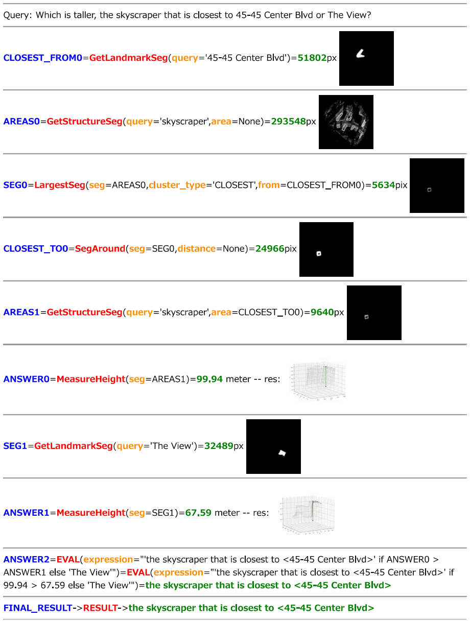
The load-bearing object is the Geography-aware City-scale 3D Language Field (GCLF): a coarse-to-fine tree of 3D Gaussians in which each node stores a compressed CLIP language embedding, combined with a georeferencing step that aligns Gaussian coordinates to real-world map coordinates. The tree structure lets rendering select only Gaussians projected smaller than one pixel, so a 2 km² scene with tens of millions of Gaussians remains interactively queryable, while the embedded CLIP features raised by an autoencoder allow open-vocabulary localization. The second half of the machinery is the API layer: nine Geographical Vision APIs (GV-APIs) that narrow the region of interest (landmark segment, direction, radius, between-segment, largest contiguous cluster), measure real-world quantities (distance and height via Gaussian geometry), or detect objects on rendered RGB images via GroundingDINO. An LLM with ten in-context examples translates a natural-language query into Python that chains these APIs, and the execution engine runs the program against GCLF. The combination is what converts a localization-only field into a compositional reasoning system.
What would settle it
Repeat the georeferencing of any single scene with a different set of landmark points chosen by another annotator, then re-run the MES-D (distance) queries; if the mean absolute error shifts by more than the reported ~50 m margin, the real-world measurement claims are not robust to the manual alignment step that supports them.
Extended reading notes
Core claim
On the paper's own terms, the discovery is that city-scale 3D language fields can be made to work by replacing the monolithic 'embed everything and retrieve' pattern with a georeferenced, hierarchy-aware field plus an API layer that an LLM composes. The framework trains a tree-structured 3D Gaussian field whose nodes carry CLIP language embeddings, georeferences the Gaussian coordinates to OpenStreetMap via a semi-automatic landmark-based transform, and answers a query by generating a Python program that calls GV-APIs such as GetLandmarkSeg, SegDirection, SegAround, MeasureDist, and GetObjectSeg. The paper reports that this program-composition approach beats existing 3D language fields on grounding, with a 45.20% localization accuracy on GoogleEarth scenes versus 14.15% for LangSplat, and that on UrbanScene3D LangSplat runs out of memory while GeoProg3D still answers queries. Across counting, measurement, comparison, and spatial reasoning, the framework's error rates are roughly two to five times better than the strongest vision-language model baselines on the tasks where geometric accuracy matters most, notably distance measurement with a mean absolute error of 49.28 m versus 89.34 m for the best VLM baseline.
Load-bearing premise
The entire measurement and directional architecture rests on the semi-automatic georeferencing step, where more than 20 hand-picked landmarks per scene align Gaussian coordinates to real-world map coordinates; a biased or imprecise alignment would systematically skew every distance, height, and directional verdict in the benchmark.
Editorial extensions
If this is right
- City-scale 3D language fields become trainable: hierarchical tree-structured Gaussians with embedded language features scale to areas exceeding 2 km², where vanilla 3D-GS-based language fields run out of memory.
- Natural-language geographic reasoning over cities becomes decomposable: counting, comparing, measuring, and spatial-relational queries can be answered by chaining a small fixed set of geographic APIs rather than training a bespoke model per task.
- The georeferenced field provides real-world measurements: because Gaussian coordinates are aligned to map coordinates, distances and heights are returned in meters and can be compared across landmarks, enabling verification against external maps.
- The framework shows viewpoint-independent localization: objects visible only from street level, such as billboards or glass facades, are localized from a top-down rendering because the 3D field stores appearance from all training views.
- A small number of in-context examples suffices: with 10–15 annotated query-program pairs, the LLM generates executable programs for over 90% of queries, and performance holds up on rephrased queries, indicating structural generalization rather than template matching.
Reading between the lines
- The decomposition principle likely transfers beyond cities: any domain where a 3D representation can be georeferenced and given a few geometric operations—indoor navigation, campus-scale robotics, or AR guidance—could inherit the same LLM-program-composition recipe without retraining.
- The manual georeferencing bottleneck is the natural place to automate; replacing the 20+ human-picked landmark points with automatic alignment (e.g., GPS-tagged images, satellite-image registration, or learned correspondence) is the most direct route to making the framework reproducible on new cities.
- The results implicitly argue that monolithic VLMs are not the right substrate for geometric 3D tasks; fusing explicit 3D geometry with an LLM via code generation may be a more sample-efficient path than scaling vision-language pretraining.
- A natural stress test is to apply the framework to a scene with significant camera distortion or with landmarks whose OSM labels are ambiguous; the observed failure cases (over-activation and adjacent-building bleed) suggest that embedding quality and georeferencing margins, not LLM reasoning, will be the limiting factors at larger scales.
Editorial analysis
A structured set of objections, weighed in public.
Referee Report
Summary. GeoProg3D proposes a visual-programming framework for city-scale 3D language fields. The system combines a hierarchical, geography-aware 3D Gaussian language field (GCLF) with a set of Geographical Vision APIs (GV-APIs); a large language model generates Python programs that call these APIs to answer compositional geographic queries. The authors introduce GeoEval3D, a benchmark of 952 query-answer pairs over five tasks (grounding, counting, measurement, comparison, spatial reasoning) in New York and Shenzhen scenes, and report substantial improvements over existing 3D language fields and vision-language models. The paper also includes ablations, a rephrased-query robustness study, and qualitative examples of viewpoint-independent localization.
Significance. If the reported results are valid, this is a meaningful step toward large-scale 3D scene understanding: the paper is, to my knowledge, the first to combine tree-structured city-scale 3D Gaussians, language embeddings, georeferencing, and LLM-generated visual programs for compositional geographic reasoning. The release of code, the inter-annotator agreement statistics in Appendix F, the ablation of the GV-API components, and the rephrased-query experiments are positive elements that support the framework's plausibility. However, the central quantitative claims currently rest on an unvalidated georeferencing step and on inconsistent numbers between the main text and appendix, and the headline comparison with VLMs is a full-system comparison rather than an apples-to-apples test of reasoning ability. The contribution is significant but conditional on addressing these evaluation issues.
major comments (4)
- [§3.2, §5.2] The georeferencing step is load-bearing for almost every quantitative claim, yet no validation is reported. Section 3.2 describes selecting more than 20 manual landmark points and fitting a scikit-image transform, but the paper gives no residual errors, no held-out landmark checks, and no sensitivity analysis. Since MES-H, MES-D, CNT area filters, SPR distance comparisons, and CMP height comparisons all operate in the transformed coordinate frame while ground-truth measurements are taken from GoogleEarth, a local bias or scale error of even a few meters would systematically shift GeoProg3D's predictions and inflate the reported margin. The failure-case discussion in §5.2 even lists "designing georeferencing to have a margin" as future work, which concedes that the alignment is known to be imperfect. Please report the fitting residuals, validate on held-out landmarks, and show that the main table results are stable under plausible perturbations of the transform.
- [Tables 4-5 vs Tables 8-9] The main text and appendix report different numbers for the same methods and tasks without explaining the protocol change. Table 5 lists LangSplat at 14.15 and GeoProg3D at 45.20 on GoogleEarth GRD, while Table 8 lists 17.07 and 46.34; Table 4 lists GeoProg3D SPR at 64.00, while Table 9 lists 71.6, with MES-H also differing (45.24 vs 13.6). If the appendix tables use a different evaluation subset, a different number of in-context examples, or only successfully executed programs, that must be stated explicitly. As written, the quantitative claims are not reproducible and the reader cannot determine which numbers constitute the official result.
- [§5.2, Table 4] The comparison against VLMs is not apples-to-apples. The VLM baselines receive a single top-down image, whereas GeoProg3D has access to the full 3D representation, georeferenced real-world coordinates, GroundingDINO object detection, and dedicated measurement APIs. This is a valid engineering-system comparison, but it does not isolate compositional reasoning; for CNT, MES-H, and MES-D, the baselines' very large MAE values may reflect the absence of scale information and 3D geometry rather than weak reasoning. Please either provide the baselines with comparable affordances (for example multiple views, scale/georeferenced orthophotos, or the same detection and measurement APIs) or explicitly frame Table 4 as a full-system comparison and add an ablation quantifying the contribution of each informational advantage.
- [§3.4, §4] The in-context examples R are hand-crafted to match the GeoEval3D query types, and GeoEval3D is introduced by the same group. The rephrased-query experiment in Appendix A.2 addresses lexical robustness, but it does not address sensitivity to the choice of ICEs or to query templates outside the benchmark. Since one of the paper's central claims is compositional generalization, please add an ablation that varies the ICE set (for example, removing query-type-specific examples) and evaluate on a small set of unseen query templates beyond paraphrases.
minor comments (4)
- [§5.2, Figure 10] GeoProg3D's counting correlation with ground truth is R²=0.27, which is modest in absolute terms; the claim of strong counting performance should be tempered or explained beyond noting that the baselines often output 1.
- [§3.4, Figure 9] The statement that 10-15 in-context examples yield "a high success rate of over 90%" is not fully supported by Figure 9, where some tasks remain below 90% even at 15 ICEs; please reconcile the text and figure.
- [Appendix D, Figure 15] There are several proofreading issues in the appendix, including the heading "GNR" instead of "GRD" in Table 12, "reporeted" in the caption of Table 12, and non-ASCII quotation marks in API arguments such as direction='west' in Figure 15.
- [§5.1] The paper states that localization accuracy is measured at an IoU threshold of 0.15 but does not justify this choice; a sentence explaining the threshold and its sensitivity would help readers interpret Tables 5 and 11.
Circularity Check
No circular derivation found; the evaluation and georeferencing concerns are validity/reproducibility issues, not self-referential reductions.
full rationale
Walking the paper's derivation chain, no step reduces to its own input. GCLF is trained from multi-view images with CLIP/SAM supervision and a hierarchical 3D-GS representation; the language embeddings are distilled from CLIP features exactly as in LangSplat, not from any GeoEval3D answer. The georeferencing step (Section 3.2) fits a global transform between manually chosen OpenStreetMap landmark points and Gaussian coordinates using scikit-image; this is a calibration of the scene's metric frame, not a fit to the ground-truth distances, heights, or counts in GeoEval3D. MeasureDist and MeasureHeight (Section 3.3) read numerical values from that calibrated frame, but the benchmark ground truth from GoogleEarth is independent of the manual landmark selection used for the transform. Any bias in the georeferencing would degrade measurement validity, but it does not make the reported MES, CNT, or SPR results true by construction. Similarly, GeoEval3D is authored by the same group and its query design is informed by the GV-APIs, but annotations were produced manually with LabelMe and GoogleEarth, and the method's parameters are not trained on the benchmark answers. The ten in-context examples are task-type demonstrations, not test-answer leakage, and the appendix's rephrased-query experiment provides an additional generalization check. The only overlapping-author citations (ScanQA [1], CityRefer [49]) appear in related work and are not load-bearing for the framework's central claims; the load-bearing building blocks -- LangSplat, hierarchical Gaussian rendering, GroundingDINO, SAM, and GPT-3.5 -- are external. The conflicting appendix tables (e.g., GRD 17.07/46.34 vs. 14.15/45.20 and SPR 71.6 vs. 64.00) are reproducibility concerns, not circularity. No fitted parameter is renamed as a prediction, no uniqueness theorem from the authors' prior work is invoked, and no ansatz is smuggled in via citation. Overall, the derivation is self-contained with respect to the paper's stated inputs.
Assumptions & free parameters
free parameters (4)
- georeferencing landmark correspondence =
>20 manual point pairs per scene
- number of in-context examples (ICEs) =
10-15
- IoU threshold for localization accuracy =
0.15
- CLIP autoencoder latent dimension =
3
assumptions (4)
- domain assumption CLIP text embeddings align with visual concepts in 3D scenes
- domain assumption OpenStreetMap landmark names and positions are accurate in the test areas
- domain assumption GoogleEarth ground truth for distances and heights is correct
- ad hoc to paper GPT-3.5 can generate correct programs from 10-15 examples
Cite this review
Pith. "Pith review of GeoProg3D: Compositional Visual Reasoning for City-Scale 3D Language Fields." pith.science (2026). https://pith.science/paper/CLTZYGMM
@misc{pith2026250623352,
  author       = {Pith},
  title        = {Pith review of: GeoProg3D: Compositional Visual Reasoning for City-Scale 3D Language Fields},
  year         = {2026},
  howpublished = {\url{https://pith.science/paper/CLTZYGMM}},
  note         = {Machine review of arXiv:2506.23352}
}
read the original abstract
The advancement of 3D language fields has enabled intuitive interactions with 3D scenes via natural language. However, existing approaches are typically limited to small-scale environments, lacking the scalability and compositional reasoning capabilities necessary for large, complex urban settings. To overcome these limitations, we propose GeoProg3D, a visual programming framework that enables natural language-driven interactions with city-scale high-fidelity 3D scenes. GeoProg3D consists of two key components: (i) a Geography-aware City-scale 3D Language Field (GCLF) that leverages a memory-efficient hierarchical 3D model to handle large-scale data, integrated with geographic information for efficiently filtering vast urban spaces using directional cues, distance measurements, elevation data, and landmark references; and (ii) Geographical Vision APIs (GV-APIs), specialized geographic vision tools such as area segmentation and object detection. Our framework employs large language models (LLMs) as reasoning engines to dynamically combine GV-APIs and operate GCLF, effectively supporting diverse geographic vision tasks. To assess performance in city-scale reasoning, we introduce GeoEval3D, a comprehensive benchmark dataset containing 952 query-answer pairs across five challenging tasks: grounding, spatial reasoning, comparison, counting, and measurement. Experiments demonstrate that GeoProg3D significantly outperforms existing 3D language fields and vision-language models across multiple tasks. To our knowledge, GeoProg3D is the first framework enabling compositional geographic reasoning in high-fidelity city-scale 3D environments via natural language. The code is available at https://snskysk.github.io/GeoProg3D/.
Figures


Figures from the paper (14 more)



Reference graph
Works this paper leans on
-
[1]
Scanqa: 3d question answering for spatial scene understanding
Daichi Azuma, Taiki Miyanishi, Shuhei Kurita, and Motoaki Kawanabe. Scanqa: 3d question answering for spatial scene understanding. In Proc. IEEE/CVF Conference on Com- puter Vision and Pattern Recognition (CVPR), pages 19129– 19139, 2022. 3
2022
-
[2]
Shuai Bai, Keqin Chen, Xuejing Liu, Jialin Wang, Wenbin Ge, Sibo Song, Kai Dang, Peng Wang, Shijie Wang, Jun Tang, Humen Zhong, Yuanzhi Zhu, Mingkun Yang, Zhao- hai Li, Jianqiang Wan, Pengfei Wang, Wei Ding, Zheren Fu, Yiheng Xu, Jiabo Ye, Xi Zhang, Tianbao Xie, Zesen Cheng, Hang Zhang, Zhibo Yang, Haiyang Xu, and Jun- yang Lin. Qwen2.5-vl technical repor...
arXiv 2025
-
[3]
Henriques, Andrew Zisserman, and Andrea Vedaldi
Yash Sanjay Bhalgat, Iro Laina, Jo ˜ao F. Henriques, Andrew Zisserman, and Andrea Vedaldi. N2f2: Hierarchical scene understanding with nested neural feature fields. In Proc. Eu- ropean Conference on Computer Vision (ECCV), 2024. 2
2024
-
[4]
Blumer, Qingx- uan Chen, and Francis Engelmann
Valentin Bieri, Marco Zamboni, Nicolas S. Blumer, Qingx- uan Chen, and Francis Engelmann. Opencity3d: 3d urban scene understanding with vision-language models. In Pro- ceedings of the IEEE/CVF Winter Conference on Applica- tions of Computer Vision (WACV). IEEE, 2025. 3
2025
-
[5]
A persistent spatial semantic representation for high-level natural language instruction execution
Valts Blukis, Chris Paxton, Dieter Fox, Animesh Garg, and Yoav Artzi. A persistent spatial semantic representation for high-level natural language instruction execution. In Proc. Conference on Robot Learning (CoRL) , pages 706– 717, 2022. 3
2022
-
[6]
Prompt-rsvqa: Prompt- ing visual context to a language model for remote sensing visual question answering
Christel Chappuis, Val ´erie Zermatten, Sylvain Lobry, Bertrand Le Saux, and Devis Tuia. Prompt-rsvqa: Prompt- ing visual context to a language model for remote sensing visual question answering. In Proc. IEEE/CVF Conference on Computer Vision and Pattern Recognition (CVPR), pages 1372–1381, 2022. 3
2022
-
[7]
Scanrefer: 3d object localization in rgb-d scans using natu- ral language
Dave Zhenyu Chen, Angel X Chang, and Matthias Nießner. Scanrefer: 3d object localization in rgb-d scans using natu- ral language. In Proc. European Conference on Computer Vision (ECCV), pages 202–221. Springer, 2020. 3
2020
-
[8]
Panoptic vision-language feature fields
Haoran Chen, Kenneth Blomqvist, Francesco Milano, and Roland Siegwart. Panoptic vision-language feature fields. IEEE Robotics and Automation Letters (RA-L) , 9(3):2144– 2151, 2024. 3
2024
Show all 96 references
-
[9]
Stylecity: Large-scale 3d urban scenes stylization
Yingshu Chen, Huajian Huang, Tuan-Anh Vu, Ka Chun Shum, and Sai-Kit Yeung. Stylecity: Large-scale 3d urban scenes stylization. In Proc. IEEE/CVF Conference on Com- puter Vision and Pattern Recognition (CVPR), 2024. 2
2024
-
[10]
Internvl: Scaling up vision foundation mod- els and aligning for generic visual-linguistic tasks
Zhe Chen, Jiannan Wu, Wenhai Wang, Weijie Su, Guo Chen, Sen Xing, Muyan Zhong, Qinglong Zhang, Xizhou Zhu, Lewei Lu, et al. Internvl: Scaling up vision foundation mod- els and aligning for generic visual-linguistic tasks. In Pro- ceedings of the IEEE/CVF Conference on Computer...
2024
-
[11]
Scannet: Richly-annotated 3d reconstructions of indoor scenes
Angela Dai, Angel X Chang, Manolis Savva, Maciej Hal- ber, Thomas Funkhouser, and Matthias Nießner. Scannet: Richly-annotated 3d reconstructions of indoor scenes. In Proc. IEEE/CVF Conference on Computer Vision and Pat- tern Recognition (CVPR), pages 5828–5839, 2017. 3
2017
-
[12]
Layoutgpt: Compositional visual plan- ning and generation with large language models
Weixi Feng, Wanrong Zhu, Tsu-jui Fu, Varun Jampani, Ar- jun Akula, Xuehai He, Sugato Basu, Xin Eric Wang, and William Yang Wang. Layoutgpt: Compositional visual plan- ning and generation with large language models. arXiv preprint arXiv:2305.15393, 2023. 3
2023 arXiv
-
[13]
Dynamic 3d gaussian fields for urban areas
Tobias Fischer, Jonas Kulhanek, Samuel Rota Bul`o, Lorenzo Porzi, Marc Pollefeys, and Peter Kontschieder. Dynamic 3d gaussian fields for urban areas. In The Thirty-eighth An- nual Conference on Neural Information Processing Systems,
-
[14]
Ue4-nerf:neural radiance field for real-time rendering of large-scale scene
Jiaming Gu, Minchao Jiang, Hongsheng Li, Xiaoyuan Lu, Guangming Zhu, Syed Afaq Ali Shah, Liang Zhang, and Mohammed Bennamoun. Ue4-nerf:neural radiance field for real-time rendering of large-scale scene. In Proc. An- nual Conference on Neural Information Processing Systems (Neu...
-
[15]
Streetsurf: Extending multi-view im- plicit surface reconstruction to street views
Jianfei Guo, Nianchen Deng, Xinyang Li, Yeqi Bai, Bo- tian Shi, Chiyu Wang, Chenjing Ding, Dongliang Wang, and Yikang Li. Streetsurf: Extending multi-view im- plicit surface reconstruction to street views. arXiv preprint arXiv:2306.04988, 2023. 2
2023 arXiv
-
[16]
Visual program- ming: Compositional visual reasoning without training
Tanmay Gupta and Aniruddha Kembhavi. Visual program- ming: Compositional visual reasoning without training. In Proc. IEEE/CVF Conference on Computer Vision and Pat- tern Recognition (CVPR), 2022. 3, 4, 5
2022
-
[17]
Pigeon: Predicting image geolocations
Lukas Haas, Michal Skreta, Silas Alberti, and Chelsea Finn. Pigeon: Predicting image geolocations. In Proc. IEEE/CVF Conference on Computer Vision and Pattern Recognition (CVPR), pages 12893–12902, 2024. 3
2024
-
[18]
Dragon: Drone and ground gaussian splatting for 3d building reconstruction
Yujin Ham, Mateusz Michalkiewicz, and Guha Balakrish- nan. Dragon: Drone and ground gaussian splatting for 3d building reconstruction. In IEEE International Conference on Computational Photography (ICCP), 2024. 2
2024
-
[19]
3d-llm: Inject- ing the 3d world into large language models
Yining Hong, Haoyu Zhen, Peihao Chen, Shuhong Zheng, Yilun Du, Zhenfang Chen, and Chuang Gan. 3d-llm: Inject- ing the 3d world into large language models. arXiv, 2023. 3
2023
-
[20]
Rsgpt: A remote sensing vision language model and benchmark
Qingqing Hu, Yue Yuan, Jie Mei, Qi Bi, Jinghui Xie, and Qiang Du. Rsgpt: A remote sensing vision language model and benchmark. arXiv preprint arXiv:2307.15266, 2023. 3
2023 arXiv
-
[21]
Teochat: A large vision-language as- sistant for temporal earth observation data
Jeremy Andrew Irvin, Emily Ruoyu Liu, Joyce Chuyi Chen, Ines Dormoy, Jinyoung Kim, Samar Khanna, Zhuo Zheng, and Stefano Ermon. Teochat: A large vision-language as- sistant for temporal earth observation data. arXiv preprint arXiv:2410.06234, 2024. 3, 7, 8, 16
-
[22]
Graspsplats: Efficient manipulation with 3d feature splatting
Mazeyu Ji, Ri-Zhao Qiu, Xueyan Zou, and Xiaolong Wang. Graspsplats: Efficient manipulation with 3d feature splatting. arXiv preprint arXiv:2409.02084, 2024. 3
2024 arXiv
-
[23]
Fastlgs: Speeding up lan- guage embedded gaussians with feature grid mapping
Yuzhou Ji, He Zhu, Junshu Tang, Wuyi Liu, Zhizhong Zhang, Xin Tan, and Yuan Xie. Fastlgs: Speeding up lan- guage embedded gaussians with feature grid mapping. In Proceedings of the AAAI Conference on Artificial Intelli- gence, 2025. 2
2025
-
[24]
3d gaussian splatting for real-time radiance field rendering
Bernhard Kerbl, Georgios Kopanas, Thomas Leimk ¨uhler, and George Drettakis. 3d gaussian splatting for real-time radiance field rendering. ACM Transactions on Graphics (TOG), 42(4), 2023. 2
2023
-
[25]
A hierarchical 3d gaussian representation for real-time ren- dering of very large datasets.ACM Transactions on Graphics (TOG), 43(4), 2024
Bernhard Kerbl, Andreas Meuleman, Georgios Kopanas, Michael Wimmer, Alexandre Lanvin, and George Drettakis. A hierarchical 3d gaussian representation for real-time ren- dering of very large datasets.ACM Transactions on Graphics (TOG), 43(4), 2024. 2
2024
-
[26]
LERF: Language embed- ded radiance fields
Justin Kerr, Chung Min Kim, Ken Goldberg, Angjoo Kanazawa, and Matthew Tancik. LERF: Language embed- ded radiance fields. In Proc. IEEE/CVF International Con- ference on Computer Vision (ICCV) , pages 19729–19739,
-
[27]
Lobell, and Ste- fano Ermon
Samar Khanna, Patrick Liu, Linqi Zhou, Chenlin Meng, Robin Rombach, Marshall Burke, David B. Lobell, and Ste- fano Ermon. Diffusionsat: A generative foundation model for satellite imagery. In Proc. International Conference on Learning Representations (ICLR), 2024. 3
2024
-
[28]
Berg, Wan-Yen Lo, Piotr Dollar, and Ross Girshick
Alexander Kirillov, Eric Mintun, Nikhila Ravi, Hanzi Mao, Chloe Rolland, Laura Gustafson, Tete Xiao, Spencer White- head, Alexander C. Berg, Wan-Yen Lo, Piotr Dollar, and Ross Girshick. Segment anything. In Proc. IEEE/CVF In- ternational Conference on Computer Vision (ICCV) , ...
2023
-
[29]
Segment any- thing
Alexander Kirillov, Eric Mintun, Nikhila Ravi, Hanzi Mao, Chloe Rolland, Laura Gustafson, Tete Xiao, Spencer White- head, Alexander C Berg, Wan-Yen Lo, et al. Segment any- thing. In Proc. IEEE/CVF International Conference on Com- puter Vision (ICCV), 2023. 3
2023
-
[30]
Satclip: Global, general- purpose location embeddings with satellite imagery
Konstantin Klemmer, Esther Rolf, Caleb Robinson, Lester Mackey, and Marc Rußwurm. Satclip: Global, general- purpose location embeddings with satellite imagery. arXiv preprint arXiv:2311.17179, 2023. 3
2023 arXiv
-
[31]
Decomposing nerf for editing via feature field dis- tillation
Sosuke Kobayashi, Eiichi Matsumoto, and Vincent Sitz- mann. Decomposing nerf for editing via feature field dis- tillation. In Proc. Annual Conference on Neural Information Processing Systems (NeurIPS), 2022. 3
2022
-
[32]
Text2pos: Text-to-point-cloud cross-modal localiza- tion
Manuel Kolmet, Qunjie Zhou, Aljo ˇsa Oˇsep, and Laura Leal- Taix´e. Text2pos: Text-to-point-cloud cross-modal localiza- tion. In Proc. IEEE/CVF Conference on Computer Vision and Pattern Recognition (CVPR), pages 6687–6696, 2022. 3
2022
-
[33]
Geochat: Grounded large vision-language model for remote sensing
Kartik Kuckreja, Muhammad Sohail Danish, Muzammal Naseer, Abhijit Das, Salman Khan, and Fahad Shahbaz Khan. Geochat: Grounded large vision-language model for remote sensing. In Proc. IEEE/CVF Conference on Com- puter Vision and Pattern Recognition (CVPR), pages 27831– 27840, 2...
2024
-
[34]
NeRF-XL: Scaling nerfs with multiple GPUs
Ruilong Li, Sanja Fidler, Angjoo Kanazawa, and Francis Williams. NeRF-XL: Scaling nerfs with multiple GPUs. In Proc. European Conference on Computer Vision (ECCV),
-
[35]
Matrixcity: A large-scale city dataset for city-scale neural rendering and beyond
Yixuan Li, Lihan Jiang, Linning Xu, Yuanbo Xiangli, Zhen- zhi Wang, Dahua Lin, and Bo Dai. Matrixcity: A large-scale city dataset for city-scale neural rendering and beyond. In Proc. IEEE/CVF International Conference on Computer Vi- sion (ICCV), pages 3205–3215, 2023. 2
2023
-
[36]
Vastgaussian: Vast 3d gaus- sians for large scene reconstruction
Jiaqi Lin, Zhihao Li, Xiao Tang, Jianzhuang Liu, Shiyong Liu, Jiayue Liu, Yangdi Lu, Xiaofei Wu, Songcen Xu, You- liang Yan, and Wenming Yang. Vastgaussian: Vast 3d gaus- sians for large scene reconstruction. In Proc. IEEE/CVF Conference on Computer Vision and Pattern Recognit...
2024
-
[37]
Capturing, reconstructing, and simulating: the urbanscene3d dataset
Liqiang Lin, Yilin Liu, Yue Hu, Xingguang Yan, Ke Xie, and Hui Huang. Capturing, reconstructing, and simulating: the urbanscene3d dataset. In Proc. European Conference on Computer Vision (ECCV), 2022. 2, 6
2022
-
[38]
Re- moteclip: A vision language foundation model for remote sensing
Fan Liu, Delong Chen, Zhangqingyun Guan, Xiaocong Zhou, Jiale Zhu, Qiaolin Ye, Liyong Fu, and Jun Zhou. Re- moteclip: A vision language foundation model for remote sensing. IEEE Transactions on Geoscience and Remote Sensing (TGRS), 62:1–16, 2024. 3
2024
-
[39]
Visual instruction tuning
Haotian Liu, Chunyuan Li, Qingyang Wu, and Yong Jae Lee. Visual instruction tuning. In Proc. Annual Conference on Neural Information Processing Systems (NeurIPS), 2023. 7, 8, 16
2023
-
[40]
Citygaus- sian: Real-time high-quality large-scale scene rendering with gaussians
Yang Liu, He Guan, Chuanchen Luo, Lue Fan, Naiyan Wang, Junran Peng, and Zhaoxiang Zhang. Citygaus- sian: Real-time high-quality large-scale scene rendering with gaussians. In Proc. European Conference on Computer Vi- sion (ECCV), 2024. 2, 7
2024
-
[41]
Citygaussianv2: Efficient and geometri- cally accurate reconstruction for large-scale scenes, 2024
Yang Liu, Chuanchen Luo, Zhongkai Mao, Junran Peng, and Zhaoxiang Zhang. Citygaussianv2: Efficient and geometri- cally accurate reconstruction for large-scale scenes, 2024. 2
2024
-
[42]
Citygaussianv2: Efficient and geometri- cally accurate reconstruction for large-scale scenes
Yang Liu, Chuanchen Luo, Zhongkai Mao, Junran Peng, and Zhaoxiang Zhang. Citygaussianv2: Efficient and geometri- cally accurate reconstruction for large-scale scenes. InICLR,
-
[43]
Chameleon: Plug-and-play compositional reasoning with large language models
Pan Lu, Baolin Peng, Hao Cheng, Michel Galley, Kai-Wei Chang, Ying Nian Wu, Song-Chun Zhu, and Jianfeng Gao. Chameleon: Plug-and-play compositional reasoning with large language models. In Proc. Annual Conference on Neu- ral Information Processing Systems (NeurIPS), 2023. 3
2023
-
[44]
Exploring models and data for remote sensing im- age caption generation
Xiaoqiang Lu, Binqiang Wang, Xiangtao Zheng, and Xue- long Li. Exploring models and data for remote sensing im- age caption generation. IEEE Transactions on Geoscience and Remote Sensing (TGRS), 56:2183–2195, 2018. 3
2018
-
[45]
Skysensegpt: A fine-grained instruction tuning dataset and model for re- mote sensing vision-language understanding
Junwei Luo, Zhen Pang, Yongjun Zhang, Tingzhu Wang, Linlin Wang, Bo Dang, Jiangwei Lao, Jian Wang, Jing- dong Chen, Yihua Tan, and Yansheng Li. Skysensegpt: A fine-grained instruction tuning dataset and model for re- mote sensing vision-language understanding. arXiv preprint a...
2024 arXiv
-
[46]
A multiscale grouping transformer with clip latents for re- mote sensing image captioning
Xiangyu Meng, Yue Cao, Bing Zhang, and Liangpei Zhang. A multiscale grouping transformer with clip latents for re- mote sensing image captioning. IEEE Transactions on Geo- science and Remote Sensing (TGRS), 62:1–15, 2024. 3
2024
-
[47]
Llama 3.2 connect 2024: Vision on the edge and mo- bile devices
Meta. Llama 3.2 connect 2024: Vision on the edge and mo- bile devices. https://ai.meta.com/blog/llama- 3 - 2 - connect - 2024 - vision - edge - mobile - devices/, 2024. 7, 8, 16
2024
-
[48]
Srinivasan, Matthew Tancik, Jonathan T
Ben Mildenhall, Pratul P. Srinivasan, Matthew Tancik, Jonathan T. Barron, Ravi Ramamoorthi, and Ren Ng. Nerf: Representing scenes as neural radiance fields for view syn- thesis. In Proc. European Conference on Computer Vision (ECCV), pages 405–421, 2020. 2
2020
-
[49]
Cityrefer: Geography-aware 3d visual grounding dataset on city-scale point cloud data
Taiki Miyanishi, Fumihiro Kitamori, Shuhei Kurita, Jin- hyuk Lee, Motoaki Kawanabe, and Naoya Inoue. Cityrefer: Geography-aware 3d visual grounding dataset on city-scale point cloud data. In Proc. Annual Conference on Neural In- formation Processing Systems (NeurIPS), 2023. 3
2023
-
[50]
Lhrs-bot: Empowering remote sensing with vgi-enhanced large multimodal language model
Dilxat Muhtar, Zhenshi Li, Feng Gu, Xueliang Zhang, and Pengfeng Xiao. Lhrs-bot: Empowering remote sensing with vgi-enhanced large multimodal language model. In Proc. European Conference on Computer Vision (ECCV), 2024. 3, 7, 8, 16
2024
-
[51]
Hello gpt-4o
OpenAI. Hello gpt-4o. https : / / openai . com / index/hello-gpt-4o/, 2024. 7, 8, 16
2024
-
[52]
Vhm: Versatile and honest vision lan- guage model for remote sensing image analysis
Chao Pang, Xingxing Weng, Jiang Wu, Jiayu Li, Yi Liu, Ji- axing Sun, Weijia Li, Shuai Wang, Litong Feng, Gui-Song Xia, and Conghui He. Vhm: Versatile and honest vision lan- guage model for remote sensing image analysis. In AAAI,
-
[53]
Langsplat: 3d language gaussian splatting
Minghan Qin, Wanhua Li, Jiawei Zhou, Haoqian Wang, and Hanspeter Pfister. Langsplat: 3d language gaussian splatting. In Proc. IEEE/CVF Conference on Computer Vision and Pat- tern Recognition (CVPR), pages 20051–20060, 2024. 2, 3, 4, 5, 6, 7, 14
2024
-
[54]
Deep semantic understanding of high resolution remote sensing image
Bo Qu, Xuelong Li, Dacheng Tao, and Xiaoqiang Lu. Deep semantic understanding of high resolution remote sensing image. In International Conference on Computer, Infor- mation and Telecommunication Systems (CITS) , pages 1–5,
-
[55]
Learn- ing transferable visual models from natural language super- vision
Alec Radford, Jong Wook Kim, Chris Hallacy, Aditya Ramesh, Gabriel Goh, Sandhini Agarwal, Girish Sastry, Amanda Askell, Pamela Mishkin, Jack Clark, et al. Learn- ing transferable visual models from natural language super- vision. In Proc. International Conference on Machine Le...
2021
-
[56]
Derf: Decom- posed radiance fields
Daniel Rebain, Wei Jiang, Soroosh Yazdani, Ke Li, Kwang Moo Yi, and Andrea Tagliasacchi. Derf: Decom- posed radiance fields. Proc. IEEE/CVF Conference on Com- puter Vision and Pattern Recognition (CVPR), pages 14148– 14156, 2020. 3
2020
-
[57]
Toolformer: Language models can teach themselves to use tools
Timo Schick, Jane Dwivedi-Yu, Roberto Dessi, Roberta Raileanu, Maria Lomeli, Luke Zettlemoyer, Nicola Can- cedda, and Thomas Scialom. Toolformer: Language models can teach themselves to use tools. 2023. 3
2023
-
[58]
Clip-fields: Weakly supervised semantic fields for robotic memory
Nur Muhammad (Mahi) Shafiullah, Chris Paxton, Lerrel Pinto, Soumith Chintala, and Arthur Szlam. Clip-fields: Weakly supervised semantic fields for robotic memory. ArXiv, abs/2210.05663, 2022. 3
2022 arXiv
-
[59]
Language embedded 3d gaussians for open- vocabulary scene understanding
Jin-Chuan Shi, Miao Wang, Hao-Bin Duan, and Shao- Hua Guan. Language embedded 3d gaussians for open- vocabulary scene understanding. InProc. IEEE/CVF Confer- ence on Computer Vision and Pattern Recognition (CVPR) , pages 5333–5343, 2024. 2, 3
2024
-
[60]
Real-time view synthesis for large scenes with millions of square meters
Qing Shuai, Haoyu Guo, Zhen Xu, Haotong Lin, Sida Peng, Hujun Bao, and Xiaowei Zhou. Real-time view synthesis for large scenes with millions of square meters. 2024. 2, 4, 14
2024
-
[61]
City-on-web: Real-time neural rendering of large- scale scenes on the web
Kaiwen Song, Xiaoyi Zeng, Chenqu Ren, and Juyong Zhang. City-on-web: Real-time neural rendering of large- scale scenes on the web. In Proc. European Conference on Computer Vision (ECCV), 2024. 2
2024
-
[62]
De- composing 3d scenes into objects via unsupervised volume segmentation
Karl Stelzner, Kristian Kersting, and Adam Kosiorek. De- composing 3d scenes into objects via unsupervised volume segmentation. 2021. 3
2021
-
[63]
Modular visual question answering via code generation
Sanjay Subramanian, Medhini Narasimhan, et al. Modular visual question answering via code generation. In Proc. An- nual Meeting of the Association for Computational Linguis- tics (ACL), 2023. 3
2023
-
[64]
3d ques- tion answering for city scene understanding
Penglei Sun, Yaoxian Song, Xiang Liu, Xiaofei Yang, Qiang Wang, Tiefeng Li, Yang Yang, and Xiaowen Chu. 3d ques- tion answering for city scene understanding. In Proc. ACM International Conference on Multimedia (ACMMM) , pages 2156–2165, 2024. 3
2024
-
[65]
Visual grounding in remote sensing images
Yuxi Sun, Shanshan Feng, Xutao Li, Yunming Ye, Jian Kang, and Xu Huang. Visual grounding in remote sensing images. In Proc. ACM International Conference on Multime- dia (ACMMM), page 404–412, New York, NY , USA, 2022. Association for Computing Machinery. 3
2022
-
[66]
ViperGPT: Visual inference via python execution for reasoning
D ´ıdac Sur´ıs, Sachit Menon, and Carl V ondrick. ViperGPT: Visual inference via python execution for reasoning. In Proc. IEEE/CVF International Conference on Computer Vi- sion (ICCV), 2023. 3, 4, 5
2023
-
[67]
Srinivasan, Jonathan T
Matthew Tancik, Vincent Casser, Xinchen Yan, Sabeek Prad- han, Ben Mildenhall, Pratul P. Srinivasan, Jonathan T. Bar- ron, and Henrik Kretzschmar. Block-nerf: Scalable large scene neural view synthesis. arXiv, 2022. 2
2022
-
[68]
Crs-diff: Controllable generative re- mote sensing foundation model
Datao Tang, Xiangyong Cao, Xingsong Hou, Zhongyuan Jiang, and Deyu Meng. Crs-diff: Controllable generative re- mote sensing foundation model. IEEE Transactions on Geo- science and Remote Sensing (TGRS), 2024. 3
2024
-
[69]
Minigpt-3d: Efficiently aligning 3d point clouds with large language models using 2d priors
Yuan Tang, Xu Han, Xianzhi Li, Qiao Yu, Yixue Hao, Long Hu, and Min Chen. Minigpt-3d: Efficiently aligning 3d point clouds with large language models using 2d priors. arXiv preprint arXiv:2405.01413, 2024. 3
2024 arXiv
-
[70]
Mega-nerf: Scalable construction of large-scale nerfs for virtual fly-throughs
Haithem Turki, Deva Ramanan, and Mahadev Satya- narayanan. Mega-nerf: Scalable construction of large-scale nerfs for virtual fly-throughs. In Proc. IEEE/CVF Confer- ence on Computer Vision and Pattern Recognition (CVPR) , pages 12922–12931, 2022. 2
2022
-
[71]
Geoclip: Clip-inspired alignment between locations and im- ages for effective worldwide geo-localization
Vicente Vivanco, Gaurav Kumar Nayak, and Mubarak Shah. Geoclip: Clip-inspired alignment between locations and im- ages for effective worldwide geo-localization. In Proc. An- nual Conference on Neural Information Processing Systems (NeurIPS), 2023. 3
2023
-
[72]
Skyscript: A large and semanti- cally diverse vision-language dataset for remote sensing
Zhecheng Wang, Rajanie Prabha, Tianyuan Huang, Jiajun Wu, and Ram Rajagopal. Skyscript: A large and semanti- cally diverse vision-language dataset for remote sensing. In Proc. AAAI Conference on Artificial Intelligence, 2024. 3
2024
-
[73]
Text2loc: 3d point cloud localization from natural language
Yan Xia, Letian Shi, Zifeng Ding, Joao F Henriques, and Daniel Cremers. Text2loc: 3d point cloud localization from natural language. In Proc. IEEE/CVF Conference on Com- puter Vision and Pattern Recognition (CVPR), pages 14958– 14967, 2024. 3
2024
-
[74]
Bungeenerf: Progressive neural radiance field for extreme multi-scale scene rendering
Yuanbo Xiangli, Linning Xu, Xingang Pan, Nanxuan Zhao, Anyi Rao, Christian Theobalt, Bo Dai, and Dahua Lin. Bungeenerf: Progressive neural radiance field for extreme multi-scale scene rendering. In The European Conference on Computer Vision (ECCV), 2022. 2
2022
-
[75]
Citydreamer: Compositional generative model of unbounded 3D cities
Haozhe Xie, Zhaoxi Chen, Fangzhou Hong, and Ziwei Liu. Citydreamer: Compositional generative model of unbounded 3D cities. In Proc. IEEE/CVF Conference on Computer Vi- sion and Pattern Recognition (CVPR), 2024. 2, 6
2024
-
[76]
GaussianCity: Generative gaussian splatting for unbounded 3D city generation
Haozhe Xie, Zhaoxi Chen, Fangzhou Hong, and Ziwei Liu. GaussianCity: Generative gaussian splatting for unbounded 3D city generation. arXiv 2406.06526, 2024. 2
2024 arXiv
-
[77]
Grid-guided neural radiance fields for large urban scenes
Linning Xu, Yuanbo Xiangli, Sida Peng, Xingang Pan, Nanxuan Zhao, Christian Theobalt, Bo Dai, and Dahua Lin. Grid-guided neural radiance fields for large urban scenes. In Proc. IEEE/CVF Conference on Computer Vision and Pat- tern Recognition (CVPR), 2023. 2
2023
-
[78]
Pointllm: Empowering large language models to understand point clouds
Runsen Xu, Xiaolong Wang, Tai Wang, Yilun Chen, Jiang- miao Pang, and Dahua Lin. Pointllm: Empowering large language models to understand point clouds. In Proc. Euro- pean Conference on Computer Vision (ECCV), 2024. 3
2024
-
[79]
Addressclip: Empowering vision-language models for city-wide image address localization
Shixiong Xu, Chenghao Zhang, Lubin Fan, and Gaofeng Meng. Addressclip: Empowering vision-language models for city-wide image address localization. In Proc. Euro- pean Conference on Computer Vision (ECCV), pages 76–92,
-
[80]
Unisim: A neural closed-loop sensor simulator
Ze Yang, Yun Chen, Jingkang Wang, Sivabalan Mani- vasagam, Wei-Chiu Ma, Anqi Joyce Yang, and Raquel Ur- tasun. Unisim: A neural closed-loop sensor simulator. In Proc. IEEE/CVF Conference on Computer Vision and Pat- tern Recognition (CVPR), pages 1389–1399, 2023. 2
2023
-
[81]
Scannet++: A high-fidelity dataset of 3d indoor scenes
Chandan Yeshwanth, Yueh-Cheng Liu, Matthias Nießner, and Angela Dai. Scannet++: A high-fidelity dataset of 3d indoor scenes. In Proc. IEEE/CVF International Conference on Computer Vision (ICCV), 2023. 3
2023
-
[82]
Dogs: Distributed-oriented gaus- sian splatting for large-scale 3d reconstruction via gaussian consensus
Gim Hee Lee Yu Chen. Dogs: Distributed-oriented gaus- sian splatting for large-scale 3d reconstruction via gaussian consensus. In arXiv, 2024. 2
2024
-
[83]
Presight: Enhancing au- tonomous vehicle perception with city-scale nerf priors
Tianyuan Yuan, Yucheng Mao, Jiawei Yang, Yicheng Liu, Yue Wang, and Hang Zhao. Presight: Enhancing au- tonomous vehicle perception with city-scale nerf priors. arXiv preprint arXiv:2403.09079, 2024. 2
2024 arXiv
-
[84]
Exploring a fine-grained multiscale method for cross-modal remote sensing image re- trieval
Zhiqiang Yuan, Wenkai Zhang, Kun Fu, Xuan Li, Chubo Deng, Hongqi Wang, and Xian Sun. Exploring a fine-grained multiscale method for cross-modal remote sensing image re- trieval. IEEE Transactions on Geoscience and Remote Sens- ing (TGRS), 60:1–19, 2022. 3
2022
-
[85]
Garfield++: Reinforced gaussian ra- diance fields for large-scale 3d scene reconstruction, 2024
Hanyue Zhang, Zhiliu Yang, Xinhe Zuo, Yuxin Tong, Ying Long, and Chen Liu. Garfield++: Reinforced gaussian ra- diance fields for large-scale 3d scene reconstruction, 2024. 2
2024
-
[86]
3DitScene: Editing any scene via language-guided disentan- gled gaussian splatting
Qihang Zhang, Yinghao Xu, Chaoyang Wang, Hsin-Ying Lee, Gordon Wetzstein, Bolei Zhou, and Ceyuan Yang. 3DitScene: Editing any scene via language-guided disentan- gled gaussian splatting. In arXiv, 2024. 3
2024
-
[87]
Earthgpt: A universal multi-modal large lan- guage model for multi-sensor image comprehension in re- mote sensing domain
Wei Zhang, Miaoxin Cai, Tong Zhang, Yin Zhuang, and Xuerui Mao. Earthgpt: A universal multi-modal large lan- guage model for multi-sensor image comprehension in re- mote sensing domain. IEEE Transactions on Geoscience and Remote Sensing (TGRS), 2024. 3
2024
-
[88]
Earthmarker: A visual prompt learning frame- work for region-level and point-level remote sensing imagery comprehension
Wei Zhang, Miaoxin Cai, Tong Zhang, Yin Zhuang, and Xuerui Mao. Earthmarker: A visual prompt learning frame- work for region-level and point-level remote sensing imagery comprehension. arXiv preprint arXiv:2407.13596, 2024. 3
2024 arXiv
-
[89]
Ef- ficient large-scale scene representation with a hybrid of high-resolution grid and plane features
Yuqi Zhang, Guanying Chen, and Shuguang Cui. Ef- ficient large-scale scene representation with a hybrid of high-resolution grid and plane features. arXiv preprint arXiv:2303.03003, 2023. 2
2023 arXiv
-
[90]
Aerial lifting: Neural urban semantic and building instance lifting from aerial imagery
Yuqi Zhang, Guanying Chen, Jiaxing Chen, and Shuguang Cui. Aerial lifting: Neural urban semantic and building instance lifting from aerial imagery. In Proc. IEEE/CVF Conference on Computer Vision and Pattern Recognition (CVPR), 2024. 2
2024
-
[91]
Rs5m and georsclip: A large-scale vision- language dataset and a large vision-language model for remote sensing
Zilun Zhang, Tiancheng Zhao, Yulong Guo, and Jianwei Yin. Rs5m and georsclip: A large-scale vision- language dataset and a large vision-language model for remote sensing. IEEE Transactions on Geoscience and Remote Sensing (TGRS) , 62, 2024. 3
2024
-
[92]
Mutual Attention Inception Network for Remote Sensing Visual Question Answering
Xiangtao Zheng, Binqiang Wang, Xingqian Du, and Xiao- qiang Lu. Mutual Attention Inception Network for Remote Sensing Visual Question Answering. IEEE Transactions on Geoscience and Remote Sensing (TGRS), 2021. 3
2021
-
[93]
Drivinggaussian: Composite gaussian splatting for surrounding dynamic au- tonomous driving scenes
Xiaoyu Zhou, Zhiwei Lin, Xiaojun Shan, Yongtao Wang, Deqing Sun, and Ming-Hsuan Yang. Drivinggaussian: Composite gaussian splatting for surrounding dynamic au- tonomous driving scenes. In Proceedings of the IEEE/CVF Conference on Computer Vision and Pattern Recognition , pages...
2024
-
[94]
Towards vision- language geo-foundation models: A survey
Yue Zhou, Litong Feng, Yiping Ke, Xue Jiang, Junchi Yan, Xue Yang, and Wayne Zhang. Towards vision- language geo-foundation models: A survey. arXiv preprint arXiv:2406.09385, 2024. 3
2024
-
[95]
3d-vista: Pre-trained transformer for 3d vision and text alignment
Ziyu Zhu, Xiaojian Ma, Yixin Chen, Zhidong Deng, Siyuan Huang, and Qing Li. 3d-vista: Pre-trained transformer for 3d vision and text alignment. In Proc. IEEE/CVF International Conference on Computer Vision (ICCV), pages 2911–2921,
-
[2023]
'yes' if {ANSWER1} < {ANSWER2} else 'no'
3 A. Additional Analysis on Visual Program- ming This section provides a detailed analysis of the visual pro- gramming component in GeoProg3D, focusing on the im- pact of in-context examples and the framework’s general- ization capabilities. A.1. Effect of In-Context Example C...
Reviewed August 6, 2026 · model on record in the stance chip above.
Discussion (0). Sign in to comment.