REVIEW 3 major objections 6 minor 15 references
Hierarchical Low-Altitude Wireless Network Empowered Air Traffic Management
T0 review · 3 major / 6 minor · reviewed 2026-08-05 · deepseek-v4-flash
Pith's one-line read A hierarchical low-altitude wireless network can route dense drone traffic through 3D corridors and avoid collisions using multi-modal monitoring.
desk verdict A coherent, well-organized framework for low-altitude ATM, but its only quantitative validation ignores the wireless impairments its own architecture depends on. read the letter →
The pith
A machine-rendered reading of the paper's core claim, the machinery that carries it, and where it could break.
The reading
What carries the argument
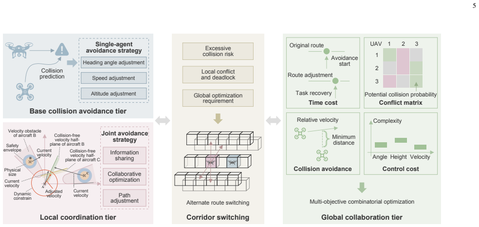
The carrying mechanism is the layered HLWN architecture built on two objects. The first is the 3D grid-discretized air corridor: coarse vertical layers and fine horizontal cubes make airspace a discrete occupancy space with one aircraft per cube, turning conflicts into geometric separations. The second is the dual-envelope aircraft model: an inner physical envelope (true airframe shape) and an outer safety envelope (dynamic buffer). Collision avoidance runs on these through four tiers—single-agent heading/speed/altitude adjustment, local coordinated path changes, corridor switching, and global multi-objective optimization—using velocity-obstacle reasoning and a conflict matrix of angle, heig
What would settle it
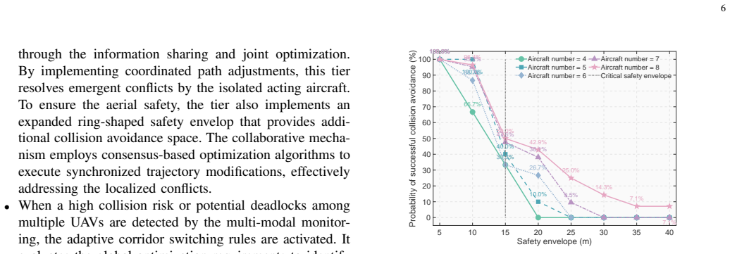
In the same 1,000 m × 1,000 m × 400 m intersection scenario, add emulated communication failures—for example, 100–200 ms added latency or 10–20% packet loss on the 5G-A and ADS-B feeds feeding the avoidance tiers—and record the collision-avoidance success probability for four aircraft at a 5 m safety envelope. If the probability drops from the reported 100%, the assumption of uninterrupted low-latency monitoring is falsified. A field version would fly two converging aircraft through an urban canyon with active RID interference and see whether the corridor-switching logic triggers before the sa
Extended reading notes
Core claim
The paper's central claim is that the proposed hierarchical low-altitude wireless network (HLWN) can guarantee safe operation and optimize low-altitude resource utilization through three-dimensional spatial discretization and integrated wireless monitoring. The framework structures airspace into coarse-grained vertical layers and fine-grained horizontal grids that define four corridor types—horizontal, vertical, high-speed, and safety corridors—with one-way traffic, consistent speeds, safe intervals, and one aircraft per grid cube. Each aircraft is wrapped in a dual envelope: a physical envelope matching its true shape and a safety envelope providing a temporal warning buffer. On this geomet
Load-bearing premise
The central safety claim assumes the multi-modal wireless monitoring (5G-A, ADS-B, RID, and GNSS) always provides accurate, current aircraft positions fast enough for the avoidance tiers to act; if coverage gaps, interference, or latency break that data stream, the corridor separation and envelope-based avoidance logic can fail.
Editorial extensions
If this is right
- Low-altitude airspace becomes regulatable as a road network: one-way corridors, entry/exit rules, speed norms, and buffer zones can be defined and enforced through geofences and monitoring.
- The dual-envelope model gives a common geometric language for collision-risk calculation across aircraft with very different shapes, from small drones to eVTOLs.
- Multi-modal monitoring coverage and data-rate gaps can be closed by switching among RID, ADS-B, 5G-A, and satellite links, making situational awareness available in both dense urban and remote areas.
- The success-probability tradeoff with envelope size implies an operational tuning knob: smaller safety envelopes allow more aircraft per corridor, but only while monitoring accuracy is high.
- The four-tier avoidance hierarchy lets immediate local maneuvers handle fast conflicts while reserving global rerouting for deadlocks, so safety actions scale with traffic density.
Reading between the lines
- The paper's safety numbers assume the monitoring feeds are accurate and timely; a natural extension is to rerun the converging-trajectory simulation with stochastic latency, packet loss, or sensor noise on the 5G-A/ADS-B channels, which the paper does not model.
- The 'one aircraft per cube' rule implies a corridor capacity bound that the paper does not compute; it could be derived from cube dimensions, safety envelope, and required spacing to quantify density limits.
- The envelope-size tradeoff could be turned into a control problem: choose the minimal safety envelope per aircraft class given localization error and response latency, a synthesis the paper leaves open.
- The HLWN framework could be stress-tested against the failure of one monitoring modality (e.g., RID interference or GNSS outage) to see whether redundancy alone preserves the avoidance guarantee; this is not tested in the case study.
Editorial analysis
A structured set of objections, weighed in public.
Referee Report
Summary. The paper proposes a Hierarchical Low-Altitude Wireless Network (HLWN) framework for low-altitude air traffic management. The framework combines 3D spatial discretization into air corridors, multi-modal wireless monitoring (GNSS, 5G-A, ADS-B, RID), aircraft envelope-based safety models, a four-tier collision avoidance mechanism, and open research directions. The authors report a MATLAB case study at a 3D corridor intersection, presenting probabilities of successful collision avoidance as a function of safety-envelope size and aircraft number, and comparing range/data rate of the monitoring modes.
Significance. If the framework and its quantitative claims were rigorously supported, the paper would be relevant to the emerging low-altitude economy and the design of future air-traffic-management systems. Its strength is the comprehensive taxonomy of components — corridor types, dual envelopes, monitoring modes, and hierarchical avoidance tiers — and the identification of open problems such as environmental complexity, multi-modal cooperation, and security. The paper does not provide machine-checked proofs, reproducible code, or parameter-free derivations; its contribution is conceptual and architectural. The main quantitative validation, however, is currently decoupled from the wireless mechanisms that are central to the framework, so the safety claims are not established.
major comments (3)
- [Section IV-C, Fig. 5] The collision-avoidance probability is not well-defined. The text reports percentages such as 100% for N=4 at small envelopes, but gives no model of the probability, no number of simulation runs, no statistical variation, and no baseline comparison. The scenario uses predefined trajectories that exactly converge at one waypoint, so the percentages appear to be deterministic outcomes of a single geometric experiment. As the only quantitative support for the abstract's 'guarantee safe operation' claim, this is load-bearing. Please either derive the probability model, provide confidence intervals, or explicitly reframe the numbers as illustrative rather than empirical validation.
- [Section IV-A vs. Section IV-C] The simulation assumes perfect wireless monitoring. Section IV-A lists real impairments — 5G-A obstruction by urban infrastructure, satellite latency, RID interference — yet none of these enter the case study. The radio parameters listed in Section IV-C (frequencies, powers, bandwidths) are never connected to the avoidance simulation; no packet loss, latency, sensor noise, update interval, or measurement error is modeled. Since multi-modal monitoring is the core enabler of the HLWN safety architecture, the validation is decoupled from the mechanism it claims to validate. At minimum, state that the results are ideal upper bounds under perfect state information, and ideally add a sensitivity study with realistic communication non-idealities.
- [Section IV-B, Fig. 4] The four-tier collision avoidance mechanism is described only qualitatively. Terms such as 'consensus-based optimization', 'multi-objective combinatorial optimization', and 'conflict matrix' are introduced without formal problem statements, algorithmic details, or properties (e.g., convergence, deadlock avoidance, safety guarantees). The paper's wording that HLWN can 'guarantee secure, orderly, and scalable air traffic management' (Section II) is therefore not supported by analysis. If the paper is intended as a vision/architecture paper, the claims should be tempered; if it claims a technical contribution, the mechanisms need formalization.
minor comments (6)
- [Throughout] The plural 'aircrafts' should be 'aircraft' throughout the manuscript.
- [Abstract] The term 'HLAN' appears in the last sentence; it should be 'HLWN'.
- [Fig. 2] 'devision' is a typo for 'division'.
- [Fig. 5] The 'Critical safety envelope' line is not explained in the text. Please define how it is determined.
- [Fig. 6] The mapping from bars to monitoring modes is ambiguous. Specify which bar corresponds to RID, 5G-A, ADS-B, and SAT, and state whether the data rates are from standards or representative values.
- [Section II] 'the 5th generation advanced (5G-A)' would be more standard as '5G-Advanced (5G-A)'.
Circularity Check
No significant circularity: the case study is a self-contained simulation, and self-citations are background only.
full rationale
The paper's central framework is a design/architecture proposal, not a derivation chain that reduces to its inputs. The self-citations ([4], [8], [9], [15]) are used for background statements such as 'high collision risks', '5G-A networks deliver ultra-low latency', and 'complex electromagnetic interference environment'. These are not load-bearing derivations; the framework does not rely on an unverified uniqueness theorem or a fitted parameter from the authors' prior work. The quantitative case study (Section IV-C) is a MATLAB simulation with predefined converging trajectories and a defined safety envelope. The reported collision-avoidance probabilities are computed from the simulated geometry and the proposed avoidance logic, not fitted to data. The monotonic decrease of success probability with envelope size is a direct consequence of the envelope definition, but the actual probability values are simulation outputs rather than equations that are identical to the inputs by construction. The paper does not 'predict' an external quantity from a fitted parameter; it demonstrates the mechanism on a toy scenario. One genuine weakness is that the case study omits the wireless non-idealities the paper itself acknowledges in Section IV-A ('signals of 5G-A may be obstructed by urban infrastructures, satellite communications suffer latency issues, and the frequencies of RID experience serious interferences'), and the simulation uses 'identical sets of the environmental factors'. That is a validity/support gap, not circularity. No circular step satisfying the quoted-evidence requirement was found.
Assumptions & free parameters
assumptions (5)
- domain assumption Low-altitude airspace (below 3,000 m) can be stratified into layers and fine-grained 3D grid units to separate air traffic.
- domain assumption Aircraft in a corridor maintain consistent velocity and one-way traffic, and each grid cube can hold only one aircraft at a time.
- domain assumption The multi-modal wireless monitoring system provides accurate real-time state information with negligible latency and no data loss.
- domain assumption In the case study, multiple aircraft have predefined trajectories that precisely converge at a single collision waypoint at the same arrival time.
- domain assumption Safety envelopes can be modeled as simple geometric shapes that trigger evasive actions before physical contact.
invented entities (1)
-
Hierarchical Low-Altitude Wireless Network (HLWN) framework
Cite this review
Pith. "Pith review of Hierarchical Low-Altitude Wireless Network Empowered Air Traffic Management." pith.science (2026). https://pith.science/paper/CP2Z423V
@misc{pith2026250903386,
  author       = {Pith},
  title        = {Pith review of: Hierarchical Low-Altitude Wireless Network Empowered Air Traffic Management},
  year         = {2026},
  howpublished = {\url{https://pith.science/paper/CP2Z423V}},
  note         = {Machine review of arXiv:2509.03386}
}
read the original abstract
As the increasing development of low-altitude aircrafts, the rational design of low-altitude networks directly impacts the aerial safety and resource utilization. To address the challenges of environmental complexity and aircraft diversity in the traffic management, we propose a hierarchical low-altitude wireless network (HLWN) framework. Empowered by the threedimensional spatial discretization and integrated wireless monitoring mechanisms in HLWN, we design low-altitude air corridors to guarantee safe operation and optimization. Besides, we develop the multi-dimensional flight risk assessment through conflict detection and probabilistic collision analysis, facilitating dynamic collision avoidance for heterogeneous aircrafts. Finally, the open issues and future directions are investigated to provide insights into HLAN development.
Figures


Figures from the paper (3 more)

Reference graph
Works this paper leans on
-
[1]
Y . Zhou, “Unmanned aerial vehicles based low-altitude economy with lifecycle techno-economic-environmental analysis for sustainable and smart cities,” J. Cleaner Prod. , vol. 499, p. 145050, Mar. 2025
work page 2025
-
[2]
Z. Li, Z. Gao, K. Wang, Y . Mei, C. Zhu, L. Chen, X. Wu, and D. Niyato, “Unauthorized UA V countermeasure for low-altitude economy: Joint communications and jamming based on MIMO cellular systems,” IEEE Internet Things J. , vol. 12, no. 6, pp. 6659–6672, Mar. 2025
work page 2025
-
[3]
Multi-objective optimization for multi-UA V-assisted mobile edge computing,
G. Sun, Y . Wang, Z. Sun, Q. Wu, J. Kang, D. Niyato, and V . C. M. Leung, “Multi-objective optimization for multi-UA V-assisted mobile edge computing,” IEEE Trans. Mob. Comput. , vol. 23, no. 12, pp. 14 803– 14 820, Aug. 2024
work page 2024
-
[4]
C. Dong, Y . Zhang, Z. Jia, Y . Liao, L. Zhang, and Q. Wu, “Three- dimension collision-free trajectory planning of UA Vs based on ADS-B information in low-altitude urban airspace,” Chin. J. Aeronaut. , vol. 38, no. 2, p. 103170, Feb. 2025
work page 2025
-
[5]
Air corridors: Concept, design, sim- ulation, and rules of engagement,
S. I. Muna, S. Mukherjee, K. Namuduri, M. Compere, M. I. Akbas, P. Molnár, and R. Subramanian, “Air corridors: Concept, design, sim- ulation, and rules of engagement,” Sensors, vol. 21, no. 22, pp. 1–18, Nov. 2021
work page 2021
-
[6]
Invited paper: Ground-based communication support for air corridors,
K. Prabhath, X. Sun, S. K. Jayaweera, D. Manu, K. Kakaraparty, S. Pallav, I. Mahbub, J. S. Mandapaka, S. Das Rochi, M. Meraz, and K. Namuduri, “Invited paper: Ground-based communication support for air corridors,” in IEEE 34th Annual International Symposium on Personal, Indoor and Mobile Radio Communications (PIMRC) , Toronto, Canada, Sep. 2023
work page 2023
-
[7]
Optimizing cellular networks for UA V corridors via quantization theory,
S. Karimi-Bidhendi, G. Geraci, and H. Jafarkhani, “Optimizing cellular networks for UA V corridors via quantization theory,” IEEE Trans. Wire- less Commun. , vol. 23, no. 10, pp. 14 924–14 939, Jul. 2024
work page 2024
-
[8]
J. Wang, Q. Zhu, Z. Lin, J. Chen, G. Ding, Q. Wu, G. Gu, and Q. Gao, “Sparse bayesian learning-based hierarchical construction for 3D radio environment maps incorporating channel shadowing,” IEEE Trans. Wireless Commun., vol. 23, no. 10, pp. 14 560–14 574, Jul. 2024
work page 2024
Show all 15 references
-
[9]
From ground to sky: Architectures, applications, and challenges shaping low-altitude wireless networks,
W. Yuan, Y . Cui, J. Wang, F. Liu, G. Sun, T. Xiang, J. Xu, S. Jin, D. Niyato, S. Coleri, S. Sun, S. Mao, A. Jamalipour, D. I. Kim, M.-S. Alouini, and X. Shen, “From ground to sky: Architectures, applications, and challenges shaping low-altitude wireless networks,” https://arx...
2025 arXiv
-
[10]
A fixed air corridor model for UAS traffic management in urban areas,
A. E. Asslouj, H. Uppaluru, M. Ramezani, E. Atkins, and H. Rastgoftar, “A fixed air corridor model for UAS traffic management in urban areas,” IEEE Trans. Aerosp. Electron. Syst. , vol. 60, no. 5, pp. 5651–5662, Oct. 2024
2024
-
[11]
Evaluating the impact of air corridors on the environment and public interests,
S. Wang, H. Liu, M. Rinaldi, and Y . P. Tsang, “Evaluating the impact of air corridors on the environment and public interests,” Transportation Research Part D: Transport and Environment , vol. 143, p. 104732, Jun. 2025
2025
-
[12]
Air corridor planning for urban drone delivery: Complexity analysis and comparison via multi- commodity network flow and graph search,
X. He, L. Li, Y . Mo, Z. Sun, and S. J. Qin, “Air corridor planning for urban drone delivery: Complexity analysis and comparison via multi- commodity network flow and graph search,” Transportation Research Part E: Logistics and Transportation Review , vol. 193, p. 103859, Jan. 2025
2025
-
[13]
A traffic control framework for uncrewed aircraft systems,
A. V . Gupta, A. P. Kattekola, A. V . Gupta, D. V . Abhiram, K. Namuduri, and R. Subramanian, “A traffic control framework for uncrewed aircraft systems,” in IEEE International Conference on Communications , Denver, CO, Jun. 2024, pp. 4518–4523
2024
-
[14]
Merging in air corridors using vehicle-to-vehicle communica- tions,
B. Dalloul, J. S. Mandapaka, L. McCorkendale, S. Nicoll, and K. Na- muduri, “Merging in air corridors using vehicle-to-vehicle communica- tions,” in IEEE International Conference on Communications , Denver, CO, Jun. 2024
2024
-
[15]
Embodied AI- empowered low altitude economy: Integrated sensing, communications, computation, and control (ISC3),
Y . Yang, Y . Chen, J. Wang, G. Sun, and D. Niyato, “Embodied AI- empowered low altitude economy: Integrated sensing, communications, computation, and control (ISC3),” https://arxiv.org/abs/2412.19996, Dec. 2024
2024 arXiv
Reviewed August 5, 2026 · model on record in the stance chip above.
Discussion (0). Continue with ORCID to comment.