Recognition: no theorem link
Large-Scale Photogrammetric Documentation of St. John's Co-Cathedral: A Workflow for Cultural Heritage Preservation
Pith reviewed 2026-05-15 06:38 UTC · model grok-4.3
The pith
A workflow captures 99,000 images to produce a 25-30 billion triangle 3D model of St. John's Co-Cathedral.
A machine-rendered reading of the paper's core claim, the machinery that carries it, and where it could break.
Core claim
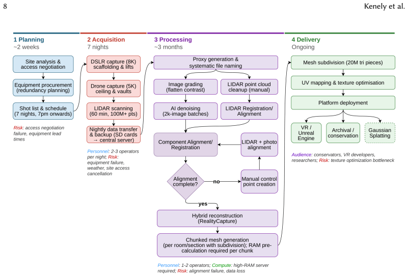
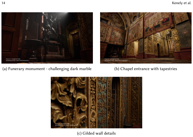
The central claim is that a hybrid photogrammetric reconstruction workflow, incorporating multi-modal data acquisition, strategic image grading, AI-assisted denoising, LIDAR cleanup, and mesh subdivision in RealityCapture, successfully creates a highly detailed 3D model of the cathedral despite challenges from reflective surfaces and intricate details.
What carries the argument
The hybrid photogrammetric reconstruction pipeline in RealityCapture that combines photogrammetry from graded images with cleaned LIDAR data and mesh subdivision strategies.
Load-bearing premise
The strategic image grading, AI-assisted denoising, extensive LIDAR cleanup, and hybrid reconstruction will reliably overcome challenges from highly reflective metallic surfaces and dark materials.
What would settle it
If the final 3D reconstruction exhibits significant geometric errors or visual artifacts in areas with metallic surfaces or dark materials, the workflow would not have succeeded at this scale.
Figures


read the original abstract
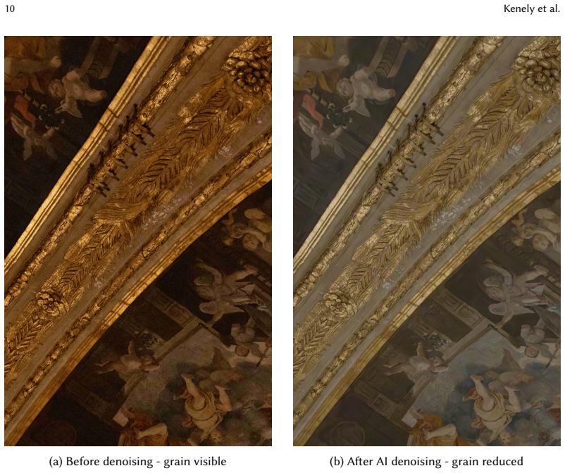
We present a comprehensive methodology for the large-scale photogrammetric documentation of St. John's Co-Cathedral in Valletta, Malta, a UNESCO World Heritage site renowned for its ornate Baroque architecture and Caravaggio masterpieces. Over seven nights of evening-only data collection, we captured 99,000 images using DSLR cameras, drone photography, and LIDAR scanning to create a highly detailed 3D reconstruction comprising 25-30 billion triangles. This paper documents our complete workflow for cultural heritage preservation, addressing the unique challenges of digitizing complex baroque architectural spaces with highly reflective metallic surfaces, dark materials, intricate tapestries, and restricted access. We detail our pipeline from multi-modal data acquisition through processing, including strategic image grading and AI-assisted denoising to address low-light grain, extensive LIDAR point cloud cleanup, hybrid photogrammetric reconstruction using RealityCapture, and mesh subdivision strategies for real-time visualization engines. Our methodology combines automated workflows with necessary manual intervention to handle the scale and complexity of the project, with particular attention to reflective surface challenges characteristic of baroque heritage sites. We also present preliminary experiments with Gaussian splatting as a complementary representation technique. The resulting digital archive serves multiple preservation purposes including disaster recovery documentation, conservation analysis, virtual tourism, and scholarly research. This work provides a detailed, replicable workflow for heritage professionals undertaking similar large-scale architectural documentation projects, addressing the practical challenges of applying photogrammetric methods in complex real-world heritage scenarios.
Editorial analysis
A structured set of objections, weighed in public.
Referee Report
Summary. The paper presents a detailed workflow for large-scale photogrammetric documentation of St. John's Co-Cathedral, a UNESCO site with complex Baroque architecture. Over seven nights, 99,000 images were captured using DSLR cameras, drone photography, and LIDAR scanning. The data were processed via strategic image grading, AI-assisted denoising, extensive LIDAR point cloud cleanup, hybrid photogrammetric reconstruction in RealityCapture, and mesh subdivision to produce a 3D model with 25-30 billion triangles. The work addresses challenges from reflective metallic surfaces, dark materials, and restricted access, includes preliminary Gaussian splatting experiments, and aims to provide a replicable methodology for heritage preservation, disaster recovery, and virtual tourism.
Significance. If the described pipeline reliably produces clean, high-fidelity models at this scale, the paper offers a valuable practical case study and replicable template for cultural heritage professionals facing similar reflective-surface and low-light challenges in large architectural sites. The reported capture volume and model size demonstrate feasibility of multi-modal acquisition under constrained conditions, which could inform future projects even if quantitative validation is added.
major comments (2)
- [Reconstruction pipeline] Reconstruction pipeline description: the central claim that strategic grading, AI-assisted denoising, LIDAR cleanup, and RealityCapture hybrid reconstruction successfully overcome highly reflective metallic surfaces and dark baroque materials is unsupported by any quantitative metrics such as RMSE against control points, before/after noise variance on reflective patches, fraction of images discarded, or denoiser parameters; without these, it is impossible to assess whether the pipeline or manual intervention was decisive.
- [Methods and results] Methods and results sections: no error analysis, ground-truth validation, or ablation of individual processing steps (e.g., denoising impact) is reported, undermining the assertion of a replicable workflow for similar heritage sites.
minor comments (2)
- [Abstract] The triangle count is given as the broad range '25-30 billion'; a single best-estimate figure or breakdown by component would improve precision.
- [Figures] Figure captions and processing diagrams could more explicitly label which steps address reflective surfaces versus general noise.
Simulated Author's Rebuttal
We thank the referee for their constructive review and for recognizing the practical value of our large-scale heritage documentation workflow. We agree that stronger quantitative support would improve the manuscript and have revised the Methods and Results sections to include available processing parameters, image statistics, and a limitations discussion. We respond to each major comment below.
read point-by-point responses
-
Referee: [Reconstruction pipeline] Reconstruction pipeline description: the central claim that strategic grading, AI-assisted denoising, LIDAR cleanup, and RealityCapture hybrid reconstruction successfully overcome highly reflective metallic surfaces and dark baroque materials is unsupported by any quantitative metrics such as RMSE against control points, before/after noise variance on reflective patches, fraction of images discarded, or denoiser parameters; without these, it is impossible to assess whether the pipeline or manual intervention was decisive.
Authors: We acknowledge the absence of quantitative metrics such as RMSE or noise variance statistics. These were not collected because the project operated under strict nighttime access limits at a UNESCO site, precluding surveyed control points or systematic patch-wise measurements. In revision we have added the exact AI denoising parameters (model version, patch size, and strength), the fraction of images discarded during grading (approximately 15%), and a supplementary figure with qualitative before/after comparisons on reflective surfaces. We have also inserted a limitations paragraph explaining why full quantitative validation was infeasible. While these additions improve transparency, we cannot retroactively supply RMSE or ablation numbers without new data acquisition. revision: partial
-
Referee: [Methods and results] Methods and results sections: no error analysis, ground-truth validation, or ablation of individual processing steps (e.g., denoising impact) is reported, undermining the assertion of a replicable workflow for similar heritage sites.
Authors: We agree that the lack of error analysis and ablation studies weakens the replicability claim. The manuscript describes a real-world case study conducted under operational constraints rather than a controlled benchmark. We have expanded the Results section with available statistics (point-cloud density before/after LIDAR cleanup, processing times) and added a short discussion of denoising effects based on visual inspection. Full ablation or ground-truth validation would require multiple complete reconstructions at 25–30 billion triangle scale, which exceeds available resources. We have revised the abstract and conclusion to describe the work as “a practical template” rather than a fully validated replicable methodology and have added a forward-looking statement inviting future quantitative studies. revision: partial
- Quantitative error metrics (RMSE against control points, before/after noise variance) and full ablation studies, as the required ground-truth data and multiple full-scale reconstruction runs were never collected or performed during the original campaign due to site-access and computational constraints.
Circularity Check
No circularity in descriptive workflow paper
full rationale
The manuscript is a methods report detailing data collection (99,000 images, DSLR, drone, LIDAR) and processing steps (image grading, AI denoising, LIDAR cleanup, RealityCapture hybrid reconstruction, mesh subdivision) for a 25-30 billion triangle model. No equations, derivations, fitted parameters, predictions, or uniqueness theorems appear. All claims are procedural descriptions of what was performed rather than reductions of outputs to inputs by construction. No self-citation chains or ansatzes are invoked as load-bearing justifications. The central claim (successful reconstruction despite reflective surfaces) rests on the reported workflow outcomes, not on any internal self-definition or renaming of known results.
Axiom & Free-Parameter Ledger
axioms (1)
- domain assumption Multi-view photogrammetry combined with LIDAR can produce accurate 3D meshes of complex architectural surfaces when sufficient overlapping images and point clouds are captured.
Reference graph
Works this paper leans on
-
[1]
https: //doi.org/10.1016/j.culher.2017.11.006 Eric F
257–266. https: //doi.org/10.1016/j.culher.2017.11.006 Eric F. Anderson, Leigh McLoughlin, Fotis Liarokapis, Christopher Peters, Panagiotis Petridis, and Sara de Freitas
-
[2]
255–275. https: //doi.org/10.1007/s10055-010-0177-3 Fabrizio Ivan Apollonio, Marco Gaiani, and Silvia Bertacchi
-
[3]
Managing Cultural Heritage With Integrated Services Platforms.International Journal of Digital Earth14, 4 (2021), 448–466. https://doi.org/10.1080/17538947.2020.1849427 Mafkereseb Kassahun Bekele, Roberto Pierdicca, Emanuele Frontoni, Eva Savina Malinverni, and James Gain
-
[4]
https://doi.org/10.1145/3145534 Matthew Berger, Andrea Tagliasacchi, Lee M
A Survey of Augmented, Virtual, and Mixed Reality for Cultural Heritage.Journal on Computing and Cultural Heritage11, 2 (2018), 7:1–7:36. https://doi.org/10.1145/3145534 Matthew Berger, Andrea Tagliasacchi, Lee M. Seversky, Pierre Alliez, Gael Guennebaud, Joshua A. Levine, Andrei Sharf, and Claudio T. Silva
-
[5]
https://doi.org/10.1111/cgf.12802 Stefano Bertocci, Matteo Bigongiari, and Andrea Pasquali
A Survey of Surface Reconstruction from Point Clouds.Computer Graphics Forum36, 1 (2017), 301–329. https://doi.org/10.1111/cgf.12802 Stefano Bertocci, Matteo Bigongiari, and Andrea Pasquali
-
[6]
Digitisation of the wooden maquette at Casa Buonarroti: a project never realised for the facade of San Lorenzo in Firenze. InProceedings of the 21st International Conference on Culture and Computer Science: from Humanism to Digital Humanities (KUI ’24). ACM. https://doi.org/10.1145/3719236.3719260 Filiberto Chiabrando, Elisabetta Donadio, and Fulvio Rinaudo
-
[7]
https://doi.org/10.5194/isprs-archives-XLI-B5-91-2016 Francesca Condorelli and Susanna Morena
SfM for orthophoto to generation: A winning approach for cultural heritage knowledge.International Archives of the Photogrammetry, Remote Sensing and Spatial Information SciencesXLI-B5 (2016), 91–98. https://doi.org/10.5194/isprs-archives-XLI-B5-91-2016 Francesca Condorelli and Susanna Morena
-
[8]
Integration of 3D modelling with photogrammetry applied on historical images for cultural heritage.VITRUVIO - International Journal of Architectural Technology and Sustainability8 (2023), 58–69. https://doi.org/10.4995/vitruvio-ijats.2023.18831 Mariella De Fino, Rosella Alessia Galantucci, and Fabio Fatiguso
-
[9]
Condition Assessment of Heritage Buildings via Photogrammetry: A Scoping Review from the Perspective of Decision Makers.Heritage6, 11 (2023), 7031–7066. https://doi.org/10.3390/heritage6110367 Susana Del Pozo, Luis Javier Sánchez-Aparicio, Pablo Rodríguez-Gonzálvez, Jesús Herrero-Pascual, Ángel Muñoz-Nieto, Diego González-Aguilera, and David Hernández-López
-
[10]
Multispectral Imaging in Cultural Heritage Conservation. International Archives of the Photogrammetry, Remote Sensing and Spatial Information SciencesXLII-2/W5 (2017), 155–162. https://doi.org/10.5194/isprs-archives-XLII-2-W5-155-2017 Francesco Fassi, Cristiana Achille, Alessandro Mandelli, Fabrizio Rechichi, and Simone Parri
work page doi:10.5194/isprs-archives-xlii-2-w5-155-2017 2017
-
[11]
A new idea of BIM system for visualization, web sharing and using huge complex 3D models for facility management.International Archives of the Photogrammetry, Remote Sensing and Spatial Information SciencesXLII-2/W2 (2017), 269–276. https: //doi.org/10.5194/isprs-archives-XLII-2-W2-269-2017 Armin Gruen, Fabio Remondino, and Li Zhang
work page doi:10.5194/isprs-archives-xlii-2-w2-269-2017 2017
-
[12]
https://doi.org/10.1111/j.0031-868X.2004.00278.x Gabriele Guidi, Michele Russo, and Diana Angheleddu
Photogrammetric Reconstruction of the Great Buddha of Bamiyan, Afghanistan.The Photogrammetric Record19, 107 (2004), 177–199. https://doi.org/10.1111/j.0031-868X.2004.00278.x Gabriele Guidi, Michele Russo, and Diana Angheleddu
-
[13]
Digital Applications in Archaeology and Cultural Heritage1, 2 (2014), 55–69
3D survey and virtual reconstruction of archaeological sites. Digital Applications in Archaeology and Cultural Heritage1, 2 (2014), 55–69. https://doi.org/10.1016/j.daach.2014.01.001 Large-Scale Photogrammetric Documentation of St. John’s Co-Cathedral 17 ICOMOS
-
[14]
https://doi.org/10.1145/3592433 Xiaonan Kong and Riley G
3D Gaussian Splatting for Real-Time Radiance Field Rendering.ACM Transactions on Graphics42, 4 (2023), 139:1–139:14. https://doi.org/10.1145/3592433 Xiaonan Kong and Riley G. Hucks
-
[16]
Recording, Documentation, and Information Management for the Conservation of Heritage Places: Guiding Principles.Getty Conservation Institute(2007). Marc Levoy, Kari Pulli, Brian Curless, Szymon Rusinkiewicz, David Koller, Lucas Pereira, Matt Ginzton, Sean Anderson, James Davis, Jeremy Ginsberg, Jonathan Shade, and Duane Fulk
work page 2007
-
[17]
The Digital Michelangelo Project: 3D Scanning of Large Statues. (2000), 131–144. https://doi.org/10.1145/344779.344849 Derek D. Lichti and Stewart J. Gordon
-
[18]
Error propagation in directly georeferenced terrestrial laser scanner point clouds for cultural heritage recording. (2004), 1–16. Eva Muñumer and José Luis Lerma
work page 2004
-
[19]
Fusion of 3D data from different image-based and range-based sources for efficient heritage recording.Digital Applications in Archaeology and Cultural Heritage16 (2020), e00141. https://doi.org/10.1016/j. daach.2020.e00141 Ariane Néroulidis, Thomas Pouyet, Sarah Tournon, Miled Rousset, Marco Callieri, Adeline Manuel, Violette Abergel, Olivier Malavergne, ...
work page doi:10.1016/j 2020
-
[20]
Erica Nocerino, Fabio Menna, Fabio Remondino, Isabella Toschi, and Pablo Rodríguez-Gonzálvez
A digital platform for the centralization and long-term preservation of multidisciplinary scientific data belonging to the Notre Dame de Paris scientific action.Journal of Cultural Heritage65 (2024), 210–220. Erica Nocerino, Fabio Menna, Fabio Remondino, Isabella Toschi, and Pablo Rodríguez-Gonzálvez
work page 2024
-
[21]
Investigation of indoor and outdoor performance of two portable mobile mapping systems.Photogrammetric Engineering and Remote Sensing83, 5 (2017), 369–380. https://doi.org/10.14358/PERS.83.5.369 Daniela Oréni, Raffaella Brumana, Stefano Della Torre, Fabrizio Banfi, Luigi Barazzetti, and Mattia Previtali
-
[22]
https://doi.org/10.5194/isprsannals-II-5-267-2014 Fabio Remondino
Survey turned into HBIM: the restoration and the work involved concerning the Basilica di Collemaggio after the earthquake (L’Aquila).ISPRS Annals of the Photogrammetry, Remote Sensing and Spatial Information SciencesII-5 (2014), 267–273. https://doi.org/10.5194/isprsannals-II-5-267-2014 Fabio Remondino
-
[23]
Heritage Recording and 3D Modeling with Photogrammetry and 3D Scanning.Remote Sensing3, 6 (2011), 1104–1138. https://doi.org/10.3390/rs3061104 Fabio Remondino, Maria Grazia Spera, Erica Nocerino, Fabio Menna, and Francesco Nex
-
[24]
https://doi.org/10.1111/phor.12063 Haithem Turki, Jason Zhang, Francesco Ferroni, and Deva Ramanan
State of the art in high density image matching.The Photogrammetric Record29, 146 (2014), 144–166. https://doi.org/10.1111/phor.12063 Haithem Turki, Jason Zhang, Francesco Ferroni, and Deva Ramanan
-
[25]
https: //doi.org/10.1109/TIP.2017.2662206
Beyond a Gaussian Denoiser: Residual Learning of Deep CNN for Image Denoising.IEEE Transactions on Image Processing26, 7 (2017), 3142–3155. https: //doi.org/10.1109/TIP.2017.2662206
discussion (0)
Sign in with ORCID, Apple, or X to comment. Anyone can read and Pith papers without signing in.