REVIEW 6 major objections 5 minor 31 references
Enhanced Vehicle Speed Detection Considering Lane Recognition Using Drone Videos in California
T0 review · 6 major / 5 minor · reviewed 2026-08-07 · deepseek-v4-flash
Pith's one-line read A fine-tuned YOLOv11 detector estimates per-lane vehicle speeds from drone video with a best mean absolute error of 0.97 mph and classifies cars versus heavy vehicles.
desk verdict Routine YOLOv11/homography speed pipeline whose headline MAE is unverifiable because ground-truth speeds are never sourced and the number is cherry-picked. read the letter →
The pith
A machine-rendered reading of the paper's core claim, the machinery that carries it, and where it could break.
The reading
What carries the argument
The load-bearing mechanism is the fine-tuned YOLOv11 detector (a single-shot object detection network) working inside a calibrated geometric pipeline: a homography matrix maps the drone's oblique region of interest to a rectified top-down plane, lane polygons assign each detected vehicle to a lane, and speed is computed as the real-world displacement of the detection between frames divided by the time interval. The two tunable parameters, drone height and ROI length, are what the paper varies to find the accuracy sweet spot.
What would settle it
Collect independent ground-truth speeds for the same vehicles—using on-board GPS or a calibrated radar gun aligned with the drone footage—and recompute MAE/MSE against those values. If the error against true speeds lands well above the paper's 0.97 mph MAE, the central accuracy claim is not supported.
Extended reading notes
Core claim
On its own terms, the paper claims that fine-tuning YOLOv11 on a custom bird's-eye dataset removes the pretrained model's failures (misclassifying vehicles as suitcases, phones, benches) and yields a system that combines detection, lane assignment via fixed lane polygons, and speed measurement through a homography-rectified region of interest. The best measured accuracy occurs at a drone altitude of 131.23 feet with a 120-foot ROI: mean absolute error of 0.97 mph and mean squared error of 0.94 mph² on the 45–55 mph speed bin, with F1 scores of 1.0 for both vehicle classes at that altitude. The paper also finds that a 96–120 foot ROI at 98–131 foot altitude keeps average speed error under about 4%.
Load-bearing premise
The load-bearing premise is that the 'Real Avg' ground-truth speeds in the error tables are accurate and independent of the detection pipeline; the paper never describes where those numbers come from, and they look like rounded bin averages, so if they were derived from the same drone video or rough manual estimates, the reported MAE/MSE would not measure true per-vehicle speed error.
Editorial extensions
If this is right
- If the reported accuracy holds, drone-based speed enforcement could operate where fixed cameras are impractical, returning per-lane speeds rather than a single spot reading.
- The car/heavy-vehicle split would let agencies enforce separate speed limits and lane restrictions for trucks and enforce HOV lane rules from aerial footage.
- The paper's optimal configuration (roughly 100–130 ft altitude, 100–120 ft ROI) gives a concrete deployment recipe for similar systems.
- A sub-1 mph MAE in the high-speed bin, if it generalizes, would make drone speed measurement competitive with ground-based radar and lidar.
- The lane-polygon approach works on unmarked rural roads as well as marked freeways, so the same pipeline adapts to both contexts.
Reading between the lines
- The paper never states how the 'Real Avg' ground-truth speeds were obtained; the values look like rounded bin means, so if ground truth came from the same video or rough estimates, the reported MAE/MSE would not reflect true per-vehicle error.
- The headline 0.97 mph MAE is for one speed bin (45–55 mph) at one configuration; average errors across all bins at that configuration are around 3.9%, so the sub-1 mph figure is not the typical performance.
- One could isolate whether the gain comes from YOLOv11's architecture or from the ROI calibration by swapping in other detectors (YOLOv8, YOLOv10) on the same pipeline.
- The tests appear to be in relatively low-density traffic; dense occlusion and partial vehicles in the ROI are not addressed, so real-world congestion could degrade both detection and speed accuracy.
Editorial analysis
A structured set of objections, weighed in public.
Referee Report
Summary. The paper proposes an integrated drone-video pipeline based on a fine-tuned YOLOv11 model that performs vehicle detection, speed estimation, lane recognition, and car/heavy-vehicle classification. The authors report a best speed-estimation performance of MAE 0.97 mph and MSE 0.94 mph² from a 45–55 mph bin at ROI=120 ft, and they study the effect of drone altitude and ROI length on speed error. Lane detection and vehicle classification are also evaluated, with qualitative demonstrations on I-80 and a rural road in Winters, California.
Significance. The paper addresses a practically relevant problem: per-lane speed enforcement and vehicle-type classification from drone footage. Its systematic variation of drone altitude and ROI length is a useful experimental design, and the qualitative demonstrations on real California roads show a potentially deployable pipeline. If the reported accuracy were rigorously supported, the contribution would be meaningful. However, the quantitative evaluation as presented has critical gaps: the ground-truth speeds are never sourced, the headline MAE is cherry-picked from a single favorable bin at one ROI, and the result tables contain arithmetic inconsistencies. The transparent speed calculation (Eq. 2) and the qualitative lane-assignment visualizations are strengths, but they do not compensate for the unsupported central accuracy claim.
major comments (6)
- [IV-A, Table I] The text reports that at 131.23 feet the average error is 6.12%, but Table I lists the average error for that height as 5.61%. This direct contradiction between the narrative and the table makes it impossible to determine which value is the reported experimental result and undermines the reliability of the entire speed-error evaluation.
- [IV-B, Table II] Several error percentages in Table II are not consistent with the reported Real Avg and MAE values. For example, for ROI=120 ft in the 35–45 mph bin, Real Avg=40 mph and MAE=1.64 mph imply an error of 4.10%, not the listed 0.67%. Similar discrepancies appear in other rows (e.g., ROI=144 ft, 35–45 mph). Since the average error values are derived from these per-bin errors, the reported results are not reproducible from the data in the table.
- [III-A, IV] The ground-truth speeds labeled "Real Avg" in Tables I and II are never defined. The paper does not state whether they were obtained from GPS, radar, manual annotation, or an independent measurement protocol, nor does it report per-vehicle sample sizes or standard deviations. The values are suspiciously clean (e.g., 20, 31.5, 40, 50 mph) and are reused across multiple ROI rows at the same height, which is consistent with assigned bin representatives rather than measured averages. Without an independent ground-truth source, the MAE, MSE, and error percentages do not support the claimed speed-detection accuracy.
- [Abstract, Table II] The headline MAE of 0.97 mph and MSE of 0.94 mph² are the best single speed bin (45–55 mph) at a single ROI (120 ft), not an overall performance measure. Other bins at the same configuration show MAE values up to 2.09 mph, and the overall average error for that ROI is 3.90%. Presenting the single most favorable bin as the system's best performance is misleading; the authors should report aggregate metrics across all speed bins and ROIs, ideally with confidence intervals.
- [V, Conclusion] The conclusion claims a 5% increase in speed-detection accuracy, a greater than 10% MAE improvement over TrackNCount and Rahutomo et al., and a 15% improvement in lane-assignment F1 from YOLOv7-RAR. None of these comparative claims are supported by experiments in the Methods or Results sections; no baseline systems are implemented or evaluated, and no lane-assignment F1 scores are reported anywhere. These unsupported claims should be removed or substantiated with direct comparisons.
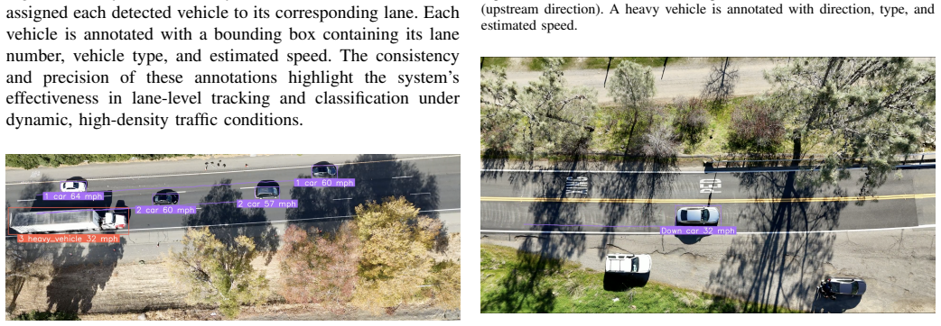
- [IV-E, Table III] Lane recognition is a central claim of the paper, yet Section IV-E provides only qualitative descriptions and annotated figures. No quantitative lane-assignment accuracy, F1 score, or comparison to prior lane-detection methods is reported, despite the conclusion citing a 15% F1 improvement. Additionally, Table III reports heavy-vehicle F1 of 89% at 65.61 ft, which contradicts the conclusion's statement of "over 90% accuracy across all vehicle types." These inconsistencies and missing metrics leave the lane-recognition contribution unverified.
minor comments (5)
- [III-A] The text says "accuracy of88%" with a missing space; please correct to "accuracy of 88%".
- [II] There are grammatical issues, e.g., "struggle detect lanes" should be "struggle to detect lanes".
- [IV] The terms MSE and MAE are not defined at first use in the body; please provide definitions or a notation section.
- [Table II] The column header "Error (%)" is ambiguous; it should be clarified as the per-bin absolute percentage error relative to Real Avg, and the average error calculation should be defined.
- [V] The conclusion contains claims about real-time performance, but no runtime or frame-rate measurements are reported anywhere in the paper.
Circularity Check
The geometric speed derivation is self-contained, but the headline 0.97 mph MAE is the minimum of the same test-table grid used to select altitude and ROI, which is a mild self-referential reporting choice.
-
other
[Abstract; Section IV-B 'Speed Estimation with Varying ROI at Fixed Drone Height'; Table II]
"The fine-tuned YOLOv11 achieved its best performance with a mean absolute error (MAE) of 0.97 mph and mean squared error (MSE) of 0.94 mph2 ... The most accurate results were observed at an ROI of 120 feet, where the average error was 3.90%, the lowest across all configurations."
The 0.97 mph MAE and 0.94 mph2 MSE are not an independent prediction from a fixed, pre-specified configuration. The drone height (131.23 ft) was declared optimal from Table I, and the ROI (120 ft) was then selected because it produced the lowest error in Table II; 'best performance' is, by construction, the minimum cell of that same evaluation table (the 45-55 mph bin). The headline value is therefore a post-hoc selection on the test set rather than a verified out-of-sample estimate, making the headline efficacy claim partly self-referential. This does not make Equation (2) circular, but it weakens the reported metric.
full rationale
The paper's derivation chain for speed is not circular: speed is computed from the geometric transformation in Equation (1) and the displacement/time formula in Equation (2), and the tabulated MAE/MSE values are arithmetic comparisons to the stated 'Real Avg' column. No equation in the paper defines the output metric in terms of the detection pipeline's fitted weights, and no prediction is forced by construction. The main validity concerns are not circularity: the 'Real Avg' ground-truth values are never sourced, the MAE/MSE entries appear to be computed from bin-average differences rather than per-vehicle residuals, and the optimal altitude/ROI configuration is selected from the same evaluation tables used to report the headline. These are reproducibility and selection-bias problems, not reductions of the derivation to its inputs. The only overlapping-author citation [31] appears in a future-work remark and is not load-bearing. Accordingly, no significant circularity is present; the score of 2 reflects the mild self-referential choice of reporting the best cell of the search grid as the system's headline performance.
Assumptions & free parameters
free parameters (3)
- YOLOv11 fine-tuning hyperparameters
- ROI lengths (72, 96, 120, 144 feet) =
72, 96, 120, 144 feet
- Lane polygon coordinates
assumptions (4)
- standard math The homography matrix estimated from four corresponding points maps image pixels to real-world ground-plane distances within the ROI (Eq. 1).
- domain assumption Vehicle speed is approximately constant while traversing the ROI, so displacement divided by time gives the true speed (Eq. 2).
- domain assumption The YOLOv11 detector, as fine-tuned, produces bounding-box centroids stable enough for sub-mph speed measurement across frames.
- domain assumption Ground-truth 'Real Avg' speeds in Tables I and II are accurate and independent of the detection pipeline.
Cite this review
Pith. "Pith review of Enhanced Vehicle Speed Detection Considering Lane Recognition Using Drone Videos in California." pith.science (2026). https://pith.science/paper/GR5I45UR
@misc{pith2026250611239,
  author       = {Pith},
  title        = {Pith review of: Enhanced Vehicle Speed Detection Considering Lane Recognition Using Drone Videos in California},
  year         = {2026},
  howpublished = {\url{https://pith.science/paper/GR5I45UR}},
  note         = {Machine review of arXiv:2506.11239}
}
abstract
The increase in vehicle numbers in California, driven by inadequate transportation systems and sparse speed cameras, necessitates effective vehicle speed detection. Detecting vehicle speeds per lane is critical for monitoring High-Occupancy Vehicle (HOV) lane speeds, distinguishing between cars and heavy vehicles with differing speed limits, and enforcing lane restrictions for heavy vehicles. While prior works utilized YOLO (You Only Look Once) for vehicle speed detection, they often lacked accuracy, failed to identify vehicle lanes, and offered limited or less practical classification categories. This study introduces a fine-tuned YOLOv11 model, trained on almost 800 bird's-eye view images, to enhance vehicle speed detection accuracy which is much higher compare to the previous works. The proposed system identifies the lane for each vehicle and classifies vehicles into two categories: cars and heavy vehicles. Designed to meet the specific requirements of traffic monitoring and regulation, the model also evaluates the effects of factors such as drone height, distance of Region of Interest (ROI), and vehicle speed on detection accuracy and speed measurement. Drone footage collected from Northern California was used to assess the proposed system. The fine-tuned YOLOv11 achieved its best performance with a mean absolute error (MAE) of 0.97 mph and mean squared error (MSE) of 0.94 $\text{mph}^2$, demonstrating its efficacy in addressing challenges in vehicle speed detection and classification.
Figures


Figures from the paper (1 more)
Reference graph
Works this paper leans on
-
[1]
D. Schrank, B. Eisele, T. Lomax et al. , “Urban mobility report 2019,” 2019. TABLE III VEHICLE TYPE DETECTION ACCURACY AT DIFFERENT DRONE HEIGHTS Drone Height (ft) Car F1 Score (%) Heavy Vehicle F1 Score (%) 65.61 97.0 89.0 98.42 100.0 100.0 131.23 100.0 100.0
work page 2019
-
[2]
Traffic safety facts 2021 a compilation of motor vehicle traffic crash data,
N. H. T. S. Administration et al., “Traffic safety facts 2021 a compilation of motor vehicle traffic crash data,” US Department of Transportation, Tech. Rep, 2023
work page 2021
-
[3]
Navigating uavs for optimal monitoring of groups of moving pedestrians or vehicles,
H. Huang and A. V . Savkin, “Navigating uavs for optimal monitoring of groups of moving pedestrians or vehicles,” IEEE Transactions on Vehicular Technology, vol. 70, no. 4, pp. 3891–3896, 2021
work page 2021
-
[4]
You only look once: Unified, real-time object detection,
J. Redmon, S. Divvala, R. Girshick, and A. Farhadi, “You only look once: Unified, real-time object detection,” in Proceedings of the IEEE conference on computer vision and pattern recognition , 2016, pp. 779– 788
2016
-
[5]
A review of vehicle detection techniques for intelligent vehicles,
Z. Wang, J. Zhan, C. Duan, X. Guan, P. Lu, and K. Yang, “A review of vehicle detection techniques for intelligent vehicles,” IEEE Transactions on Neural Networks and Learning Systems , vol. 34, no. 8, pp. 3811– 3831, 2022
work page 2022
-
[6]
Vehicle speed detection sys- tem,
C. Pornpanomchai and K. Kongkittisan, “Vehicle speed detection sys- tem,” in 2009 IEEE international conference on signal and image processing applications. IEEE, 2009, pp. 135–139
work page 2009
-
[7]
Vehicle speed detection by using camera and image processing software,
H. Koyuncu and B. Koyuncu, “Vehicle speed detection by using camera and image processing software,” The International Journal of Engineer- ing and Science (IJES) , vol. 7, no. 9, pp. 64–72, 2018
work page 2018
-
[8]
Real-time detec- tion of vehicle speed based on video image,
G. Cheng, Y . Guo, X. Cheng, D. Wang, and J. Zhao, “Real-time detec- tion of vehicle speed based on video image,” in 2020 12th International Conference on Measuring Technology and Mechatronics Automation (ICMTMA). IEEE, 2020, pp. 313–317
work page 2020
Show all 31 references
-
[9]
Vehicle speed estimation using consecutive frame approaches and deep image homography for image rectification on monocular videos,
D. A. Kamil, A. Harjoko, K.-H. Jo et al. , “Vehicle speed estimation using consecutive frame approaches and deep image homography for image rectification on monocular videos,” IEEE Access, 2024
2024
-
[10]
Vehicle tracking algorithm of speed estimation based on traffic video analysis,
M. Yashina, Y . A. Akilin, V . Osada, and A. Smyk, “Vehicle tracking algorithm of speed estimation based on traffic video analysis,” in 2024 Intelligent Technologies and Electronic Devices in Vehicle and Road Transport Complex (TIRVED). IEEE, 2024, pp. 1–6
2024
-
[11]
From stationary to nonstationary uavs: Deep-learning- based method for vehicle speed estimation,
M. W. Ahmed, M. Adnan, M. Ahmed, D. Janssens, G. Wets, A. Ahmed, and W. Ectors, “From stationary to nonstationary uavs: Deep-learning- based method for vehicle speed estimation,” Algorithms, vol. 17, no. 12, p. 558, 2024
2024
-
[12]
Vehicle speed calculation from drone video based on deep learning,
T. Rahman, M. A. L. Siregar, A. Kurniawan, S. Juniastuti, and E. M. Yuniarno, “Vehicle speed calculation from drone video based on deep learning,” in 2020 International Conference on Computer Engineering, Network, and Intelligent Multimedia (CENIM) . IEEE, 2020, pp. 229– 233
2020
-
[13]
Refining yolov4 for vehicle detection,
P. Mahto, P. Garg, P. Seth, and J. Panda, “Refining yolov4 for vehicle detection,” International Journal of Advanced Research in Engineering and Technology (IJARET), vol. 11, no. 5, 2020
2020
-
[14]
Investi- gation of a promoted you only look once algorithm and its application in traffic flow monitoring,
C.-Y . Cao, J.-C. Zheng, Y .-Q. Huang, J. Liu, and C.-F. Yang, “Investi- gation of a promoted you only look once algorithm and its application in traffic flow monitoring,” Applied Sciences , vol. 9, no. 17, p. 3619, 2019
2019
-
[15]
Yolov11 for vehicle detection: Advancements, perfor- mance, and applications in intelligent transportation systems,
M. A. R. Alif, “Yolov11 for vehicle detection: Advancements, perfor- mance, and applications in intelligent transportation systems,” arXiv preprint arXiv:2410.22898, 2024
2024 arXiv
-
[16]
Yolov8 to yolo11: A comprehensive architecture in-depth compar- ative review,
P. Hidayatullah, N. Syakrani, M. R. Sholahuddin, T. Gelar, and R. Tuba- gus, “Yolov8 to yolo11: A comprehensive architecture in-depth compar- ative review,” arXiv preprint arXiv:2501.13400 , 2025
2025 arXiv
-
[17]
Yolo evolution: A comprehensive benchmark and architectural review of yolov12, yolo11, and their previous versions,
N. Jegham, C. Y . Koh, M. Abdelatti, and A. Hendawi, “Yolo evolution: A comprehensive benchmark and architectural review of yolov12, yolo11, and their previous versions,” Yolo11, and Their Previous Versions
-
[18]
Real-time vehicle detection and urban traffic behavior analysis based on uav traffic videos on mobile devices,
Y . Zhu, Y . Wang, Y . An, H. Yang, and Y . Pan, “Real-time vehicle detection and urban traffic behavior analysis based on uav traffic videos on mobile devices,” arXiv preprint arXiv:2402.16246 , 2024
2024 arXiv
-
[19]
Simple online and realtime tracking,
A. Bewley, Z. Ge, L. Ott, F. Ramos, and B. Upcroft, “Simple online and realtime tracking,” in 2016 IEEE international conference on image processing (ICIP). Ieee, 2016, pp. 3464–3468
2016
-
[20]
Advanced computer vision for extracting georeferenced vehicle trajectories from drone imagery,
R. Fonod, H. Cho, H. Yeo, and N. Geroliminis, “Advanced computer vision for extracting georeferenced vehicle trajectories from drone imagery,” arXiv preprint arXiv:2411.02136 , 2024
2024 arXiv
-
[21]
Yolov7-rar for urban vehicle detection,
Y . Zhang, Y . Sun, Z. Wang, and Y . Jiang, “Yolov7-rar for urban vehicle detection,” Sensors, vol. 23, no. 4, p. 1801, 2023
2023
-
[22]
An asymmetric selective kernel network for drone-based vehicle detection to build a high-accuracy vehicle trajectory dataset,
Z. Wang, X. Lu, and Z. Yu, “An asymmetric selective kernel network for drone-based vehicle detection to build a high-accuracy vehicle trajectory dataset,” Remote Sensing, vol. 17, no. 3, p. 407, 2025
2025
-
[23]
Trackncount- intelligent vehicle tracking, counting, and speed estimation using yolov8 and deepsort algorithms,
B. Sathiyaprasad, P. A. R. Reddy, and D. M. Venkatesh, “Trackncount- intelligent vehicle tracking, counting, and speed estimation using yolov8 and deepsort algorithms,” in 2025 6th International Conference on Mobile Computing and Sustainable Informatics (ICMCSI). IEEE, 2025, p...
2025
-
[24]
Simple online and realtime tracking with a deep association metric,
N. Wojke, A. Bewley, and D. Paulus, “Simple online and realtime tracking with a deep association metric,” in 2017 IEEE international conference on image processing (ICIP) . IEEE, 2017, pp. 3645–3649
2017
-
[25]
Vehicle speed estimation system and automatic license plate recognition using yolov8 and easyocr on traffic camera footage,
F. Rahutomo, I. Derry, M. Anwar, S. Pramono, and M. H. Ibrahim, “Vehicle speed estimation system and automatic license plate recognition using yolov8 and easyocr on traffic camera footage,” in 2024 IEEE 2nd International Conference on Electrical Engineering, Computer and Infor...
2024
-
[26]
Determining vehicle speed based on video using convolutional neural network,
A. Grents, V . Varkentin, and N. Goryaev, “Determining vehicle speed based on video using convolutional neural network,” Transportation Research Procedia, vol. 50, pp. 192–200, 2020
2020
-
[27]
Citysim: A drone-based vehicle trajectory dataset for safety- oriented research and digital twins,
O. Zheng, M. Abdel-Aty, L. Yue, A. Abdelraouf, Z. Wang, and N. Mah- moud, “Citysim: A drone-based vehicle trajectory dataset for safety- oriented research and digital twins,” Transportation research record, vol. 2678, no. 4, pp. 606–621, 2024
2024
-
[28]
car detect dataset,
arac, “car detect dataset,” https://universe.roboflow.com/arac-zxyoi/car- detect-zefse , aug 2024, visited on 2025-01-27. [Online]. Available: https://universe.roboflow.com/arac-zxyoi/car-detect-zefse
2024
-
[29]
Vehicle speed detection system utilizing yolov8: Enhancing road safety and traffic management for metropolitan areas,
S. Shaqib, A. P. Alo, S. S. Ramit, A. U. H. Rupak, S. S. Khan, and M. S. Rahman, “Vehicle speed detection system utilizing yolov8: Enhancing road safety and traffic management for metropolitan areas,” 2024
2024
-
[30]
Multi- step deep koopman network (mdk-net) for vehicle control in frenet frame,
M. Abtahi, M. Rabbani, A. Abdolmohammadi, and S. Nazari, “Multi- step deep koopman network (mdk-net) for vehicle control in frenet frame,” arXiv preprint arXiv:2503.03002 , 2025
2025
-
[31]
Motorcycle crashes in california: analysis of crash severity and contributing factors,
A. Mamlouk, A. Teymouri, and M. G. Abadi, “Motorcycle crashes in california: analysis of crash severity and contributing factors,” in International Conference on Transportation and Development 2024 , 2024, pp. 166–177
2024
Reviewed August 7, 2026 · model on record in the stance chip above.
Discussion (0). Continue with ORCID to comment.