Agentic AI for Remote Sensing: Technical Challenges and Research Directions
Pith reviewed 2026-05-14 20:52 UTC · model grok-4.3
The pith
Earth Observation workflows impose structural challenges on generic agentic AI, necessitating new design principles for geospatial agents.
A machine-rendered reading of the paper's core claim, the machinery that carries it, and where it could break.
Core claim
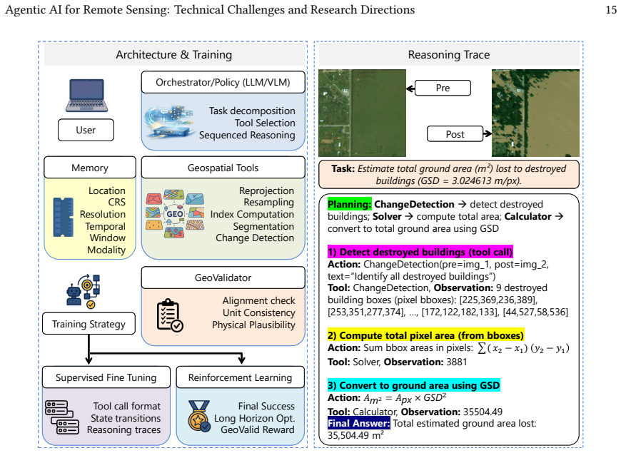
The paper claims that the challenges in applying agentic AI to Earth Observation are structural, arising from the georeferenced, temporally structured, and physically constrained nature of EO data and workflows. Operations such as resampling and aggregation transform the underlying state, making errors propagate across steps in ways that generic systems do not handle. Therefore, EO-native agents must be designed with structured geospatial state, tool-aware reasoning, verifier-guided execution, and validity-aware learning to ensure correctness.
What carries the argument
EO-native agent design principles centered on structured geospatial state, tool-aware reasoning that respects data transformations, verifier-guided execution for consistency checks, and validity-aware learning and evaluation.
If this is right
- Multi-step EO pipelines require explicit tracking of how operations transform geospatial properties to avoid undetected inconsistencies.
- Verification must extend beyond logical coherence to include physical validity and temporal consistency across workflow steps.
- Agent evaluation in EO settings needs metrics that capture geospatial accuracy and error propagation in addition to task completion.
- New agent architectures tailored to physical and geospatial constraints will be essential rather than adaptations of general frameworks.
- Reliable long-horizon reasoning becomes possible for applications such as data compositing and change detection once these principles are adopted.
Where Pith is reading between the lines
- The same structural mismatch between generic agents and domain-specific state transformations may appear in other fields that involve coordinate systems or physical simulations.
- Embedding domain verifiers as core components could become standard practice for agentic systems in scientific data analysis.
- Empirical tests on public EO benchmark datasets could quantify how much the proposed design principles reduce silent failure rates compared with unmodified agents.
Load-bearing premise
That the identified failure modes and constraints in EO workflows cannot be adequately addressed through incremental extensions of existing generic agentic AI frameworks and instead require fundamentally new design principles.
What would settle it
A demonstration that a generic agentic system can complete a complex multi-step EO workflow such as time-series change detection involving reprojection, resampling, and aggregation while preserving physical validity and geospatial consistency without custom EO-specific modules.
Figures


read the original abstract
Earth Observation (EO) is moving beyond static prediction toward multi-step analytical workflows that require coordinated reasoning over data, tools, and geospatial state. While foundation models and vision-language models have advanced representation learning and language-grounded interaction in remote sensing, and agentic AI has shown strong potential for long-horizon reasoning and tool use, EO is not a straightforward extension of generic agentic AI. EO workflows operate on georeferenced, multi-modal, and temporally structured data, where operations such as reprojection, resampling, compositing, and aggregation transform the underlying state and can constrain later analysis. As a result, errors may propagate silently across steps, and correctness depends not only on internal coherence but also on geospatial consistency, temporally valid comparisons, and physical validity. This position paper argues that these challenges are structural rather than incidental. We examine the assumptions commonly made in generic agentic systems, analyze how they break in geospatial workflows, and characterize failure modes in multi-step EO pipelines. We then outline design principles for EO-native agents centered on structured geospatial state, tool-aware reasoning, verifier-guided execution, and validity-aware learning and evaluation. Building reliable geospatial agents, therefore, requires rethinking agent design around the physical, geospatial, and workflow constraints that govern EO analysis.
Editorial analysis
A structured set of objections, weighed in public.
Referee Report
Summary. This position paper claims that Earth Observation (EO) workflows introduce structural challenges for generic agentic AI systems because operations like reprojection, resampling, compositing, and aggregation transform geospatial state and can cause silent error propagation, requiring not only internal coherence but also geospatial and physical validity. It examines breakdowns of standard agent assumptions in multi-step EO pipelines and outlines four design principles for EO-native agents: structured geospatial state, tool-aware reasoning, verifier-guided execution, and validity-aware learning and evaluation.
Significance. If the structural nature of the challenges and the necessity of the proposed principles hold, the paper could meaningfully guide research at the intersection of agentic AI and remote sensing by highlighting domain-specific constraints that generic frameworks may not address through simple extensions. As a position paper it contributes by framing failure modes and research directions rather than presenting new empirical results.
major comments (2)
- [§3] §3 (failure modes in multi-step EO pipelines): the central assertion that the identified challenges are structural and cannot be adequately addressed by incremental extensions to generic agentic frameworks (e.g., adding georeferenced state graphs or precondition checkers) is not supported by a concrete counter-example or case where such an augmentation still produces unrecoverable geospatial inconsistency or silent error propagation.
- [§4] §4 (design principles): the four proposed principles are described at a high conceptual level without formal definitions, pseudocode, or a worked example showing how 'structured geospatial state' or 'verifier-guided execution' would be realized in an agent architecture and would demonstrably mitigate the failure modes from §3.
minor comments (2)
- [Abstract and §4] The abstract and §4 refer to 'validity-aware learning and evaluation' but the text provides no detail on the learning mechanism, loss functions, or evaluation protocol that would implement this principle.
- [§2] A small number of citations to recent agentic AI surveys or EO workflow papers could be added to strengthen the grounding of the assumptions examined in §2.
Simulated Author's Rebuttal
We thank the referee for the constructive and detailed feedback. As a position paper, our goal is to frame structural challenges and research directions rather than provide empirical benchmarks. We address the major comments below and will revise the manuscript to incorporate concrete illustrations and more formal elements where feasible.
read point-by-point responses
-
Referee: [§3] §3 (failure modes in multi-step EO pipelines): the central assertion that the identified challenges are structural and cannot be adequately addressed by incremental extensions to generic agentic frameworks (e.g., adding georeferenced state graphs or precondition checkers) is not supported by a concrete counter-example or case where such an augmentation still produces unrecoverable geospatial inconsistency or silent error propagation.
Authors: We agree that a concrete counter-example would make the structural claim more compelling. Section 3 analyzes how operations such as reprojection, resampling, and aggregation transform geospatial state and enable silent error propagation, but does not include an end-to-end case demonstrating failure of incremental extensions. In the revision we will add a worked illustrative pipeline (e.g., temporal compositing followed by change detection) showing that simply augmenting an agent with georeferenced state graphs and precondition checkers still permits unrecoverable inconsistency when physical validity constraints are not explicitly enforced. revision: yes
-
Referee: [§4] §4 (design principles): the four proposed principles are described at a high conceptual level without formal definitions, pseudocode, or a worked example showing how 'structured geospatial state' or 'verifier-guided execution' would be realized in an agent architecture and would demonstrably mitigate the failure modes from §3.
Authors: The principles are presented at a conceptual level because the paper is a position piece outlining research directions rather than an architectural specification. We acknowledge that formal definitions, pseudocode, and a mitigation example would improve clarity. In the revision we will introduce concise formal definitions for each principle, provide pseudocode for the structured geospatial state representation and verifier-guided execution loop, and include a worked example that directly maps back to the failure modes in §3 to illustrate mitigation. revision: yes
Circularity Check
Position paper identifies EO-specific agentic challenges without circular derivation
full rationale
The paper is a conceptual position piece that examines standard assumptions in generic agentic systems (stateless tool calls, internal coherence only) and describes how they break under EO operations such as reprojection and temporal compositing. No equations, fitted parameters, predictions, or self-citations appear in the provided text. The claim that challenges are structural and require new design principles is advanced by direct analysis of workflow constraints rather than by reducing to a prior self-citation or definitional loop. The absence of any load-bearing self-referential step keeps the derivation self-contained against external benchmarks of agent limitations and geospatial data properties.
Axiom & Free-Parameter Ledger
axioms (2)
- domain assumption EO workflows operate on georeferenced, multi-modal, and temporally structured data where operations such as reprojection and compositing transform the underlying state and constrain later analysis
- domain assumption Errors may propagate silently across steps in multi-step EO pipelines, with correctness depending on geospatial consistency and physical validity
Lean theorems connected to this paper
-
IndisputableMonolith/Foundation/RealityFromDistinction.leanreality_from_one_distinction unclear?
unclearRelation between the paper passage and the cited Recognition theorem.
EO workflows operate over georeferenced, multi-modal, and temporally structured data, where operations such as reprojection, resampling, compositing, and aggregation actively transform the underlying state
-
IndisputableMonolith/Cost/FunctionalEquation.leanwashburn_uniqueness_aczel unclear?
unclearRelation between the paper passage and the cited Recognition theorem.
correctness depends not only on internal coherence but also on geospatial consistency, temporally valid comparisons, and physical validity
What do these tags mean?
- matches
- The paper's claim is directly supported by a theorem in the formal canon.
- supports
- The theorem supports part of the paper's argument, but the paper may add assumptions or extra steps.
- extends
- The paper goes beyond the formal theorem; the theorem is a base layer rather than the whole result.
- uses
- The paper appears to rely on the theorem as machinery.
- contradicts
- The paper's claim conflicts with a theorem or certificate in the canon.
- unclear
- Pith found a possible connection, but the passage is too broad, indirect, or ambiguous to say the theorem truly supports the claim.
Forward citations
Cited by 1 Pith paper
-
HydroAgent: Closing the Gap Between Frontier LLMs and Human Experts in Hydrologic Model Calibration via Simulator-Grounded RL
HydroAgent fine-tunes Qwen3-4B on 2,576 expert calibration trajectories and applies Group-Relative Policy Optimization with NSE reward from live CREST simulations to improve hydrologic model calibration over frontier LLMs.
discussion (0)
Sign in with ORCID, Apple, or X to comment. Anyone can read and Pith papers without signing in.