Uncertainty-aware tree height change regression
Pith reviewed 2026-07-02 14:33 UTC · model grok-4.3
The pith
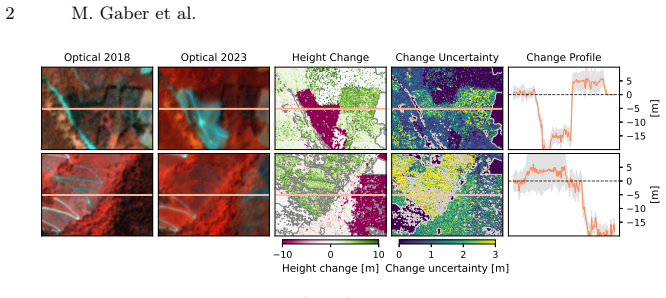
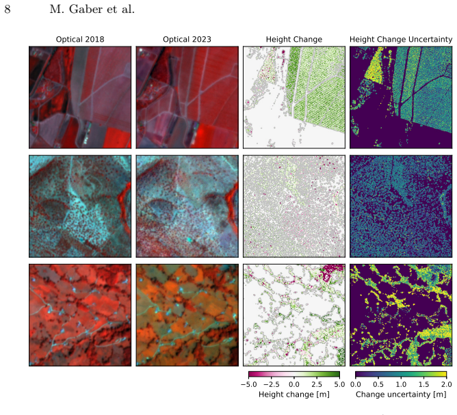
The Canopy Height Change dataset supplies continuous 3 m canopy height differences with spatially resolved uncertainties over 10598 km² in Spain, paired with PlanetScope imagery to support uncertainty-aware regression.
A machine-rendered reading of the paper's core claim, the machinery that carries it, and where it could break.
Core claim
We present the Canopy Height Change (CHC) dataset, providing 3 m resolution continuous canopy height differences and associated spatially resolved uncertainties across 10598 km² of northern and western Spain. The dataset is paired with a co-located time series of PlanetScope satellite imagery. Based on the dataset, we introduce the task of uncertainty-aware change regression, associated metrics and strategies for fine-tuning GFMs. Furthermore, we evaluate state-of-the-art GFMs and highlight promising directions and remaining challenges for advancing continuous canopy height change estimation.
What carries the argument
The Canopy Height Change (CHC) dataset supplying continuous canopy height differences and spatially resolved uncertainties at 3 m resolution, which enables the uncertainty-aware change regression task.
If this is right
- Continuous rather than binary labels allow models to capture the full range of vegetation height changes.
- Spatially resolved uncertainties enable training and evaluation that accounts for varying label reliability across pixels.
- Fine-tuning strategies for geospatial foundation models can leverage the paired imagery and labels to improve performance on the regression task.
- The dataset supports consistent large-area monitoring of forest dynamics relevant to carbon accounting.
Where Pith is reading between the lines
- Similar uncertainty-labeled datasets for other forested regions could allow extension of the regression approach to continental or global scales.
- The framework might integrate with process-based ecological models to refine estimates of carbon fluxes from small height changes.
- Persistent model challenges on the task suggest that multi-sensor fusion or targeted architectural adaptations could reduce residual errors in continuous estimates.
Load-bearing premise
The spatially resolved uncertainties supplied with the CHC labels are treated as reliable ground truth for training and evaluation.
What would settle it
Independent field measurements or higher-resolution lidar validation that shows the provided per-pixel uncertainty values fail to correlate with actual height-change prediction errors would falsify the grounding for uncertainty-aware metrics and fine-tuning.
Figures

read the original abstract
Monitoring canopy height change is essential for understanding carbon sinks and forest dynamics. Remote sensing enables consistent, large-scale observations of such changes, increasingly integrated with deep learning architectures such as Geospatial Foundation Models (GFMs). However, existing methods and datasets frame the problem as binary change detection, which overlooks both the continuous nature of change, especially for vegetation, and the inherent uncertainty in labels. We present the Canopy Height Change (CHC) dataset, providing 3 $\mathrm{m}$ resolution continuous canopy height differences and associated spatially resolved uncertainties across 10598 $\mathrm{km}^2$ of northern and western Spain. The dataset is paired with a co-located time series of PlanetScope satellite imagery. Based on the dataset, we introduce the task of uncertainty-aware change regression, associated metrics and strategies for fine-tuning GFMs. Furthermore, we evaluate state-of-the-art GFMs and highlight promising directions and remaining challenges for advancing continuous canopy height change estimation.
Editorial analysis
A structured set of objections, weighed in public.
Referee Report
Summary. The manuscript presents the Canopy Height Change (CHC) dataset, which supplies 3 m resolution continuous canopy height differences and associated spatially resolved uncertainties over 10598 km² in northern and western Spain, co-located with a PlanetScope time series. It defines the task of uncertainty-aware change regression, introduces associated metrics and fine-tuning strategies for geospatial foundation models (GFMs), and benchmarks several state-of-the-art GFMs on the new dataset.
Significance. If the provided uncertainties prove reliable, the dataset and task formulation would enable a shift from binary change detection to continuous, uncertainty-aware regression for large-scale forest monitoring. The scale of the released data and the explicit treatment of label uncertainty represent a concrete step toward more robust deep-learning pipelines in remote sensing.
major comments (2)
- [Dataset construction] Dataset construction section: the manuscript supplies no description of the source data or algorithm used to generate the continuous height-difference labels and their spatially resolved uncertainties. Without this information it is impossible to assess whether the uncertainties are unbiased proxies for label noise or whether they are correlated with the height signal itself.
- [Evaluation and fine-tuning] Evaluation and fine-tuning sections: the proposed uncertainty-aware metrics and GFM fine-tuning strategies treat the supplied uncertainty maps as ground truth. No external validation (e.g., comparison against withheld high-precision LiDAR or repeated measurements) is reported to confirm that these maps are accurate and independent of the height-difference values.
Simulated Author's Rebuttal
We thank the referee for the positive assessment of our work's significance and for the constructive major comments. We address each point below and will revise the manuscript to improve completeness.
read point-by-point responses
-
Referee: [Dataset construction] Dataset construction section: the manuscript supplies no description of the source data or algorithm used to generate the continuous height-difference labels and their spatially resolved uncertainties. Without this information it is impossible to assess whether the uncertainties are unbiased proxies for label noise or whether they are correlated with the height signal itself.
Authors: We agree that the manuscript does not describe the source data or algorithm used to generate the CHC labels and uncertainties. This information is necessary for readers to evaluate the uncertainties. In the revised version we will expand the Dataset Construction section with the required details on data sources and the derivation algorithm. revision: yes
-
Referee: [Evaluation and fine-tuning] Evaluation and fine-tuning sections: the proposed uncertainty-aware metrics and GFM fine-tuning strategies treat the supplied uncertainty maps as ground truth. No external validation (e.g., comparison against withheld high-precision LiDAR or repeated measurements) is reported to confirm that these maps are accurate and independent of the height-difference values.
Authors: We acknowledge that the manuscript reports no external validation of the uncertainty maps against independent high-precision references. The current work defines the uncertainty-aware task using the supplied maps. In revision we will add an explicit discussion of this assumption and its limitations in the Evaluation section, along with any feasible internal checks. A dedicated external validation study lies outside the present scope. revision: partial
Circularity Check
No circularity: dataset release and task definition with no derivation chain
full rationale
The paper presents the CHC dataset of continuous canopy height differences with associated uncertainties, paired with PlanetScope imagery, and defines the task of uncertainty-aware change regression along with associated metrics. No equations, fitted parameters, or predictions are introduced that reduce by construction to the paper's own inputs or self-citations. The contribution is an empirical data release plus task framing; the uncertainties are supplied as part of the dataset labels rather than derived via any load-bearing self-referential step. This matches the default expectation of no circularity for dataset papers.
Axiom & Free-Parameter Ledger
axioms (1)
- domain assumption PlanetScope imagery time series contain sufficient signal to regress continuous canopy height change at 3 m resolution
Reference graph
Works this paper leans on
-
[1]
In: ICML (2017) Uncertainty-aware tree height change regression 15
Arpit, D., Jastrzębski, S., Ballas, N., Krueger, D., Bengio, E., Kanwal, M.S., Ma- haraj, T., Fischer, A., Courville, A., Bengio, Y., Lacoste-Julien, S.: A closer look at memorization in deep networks. In: ICML (2017) Uncertainty-aware tree height change regression 15
2017
-
[2]
net / dataformats/laz/LAS_1_4_r15.pdf
ASPRS: LAS specification 1.4 – R15 (2019),https : / / paulbourke . net / dataformats/laz/LAS_1_4_r15.pdf
2019
-
[3]
In: ICCV (2023)
Bastani, F., Wolters, P., Gupta, R., Ferdinando, J., Kembhavi, A.: SatlasPretrain: a large-scale dataset for remote sensing image understanding. In: ICCV (2023)
2023
-
[4]
In: ICML (2019)
Chen, P., Liao, B.B., Chen, G., Zhang, S.: Understanding and utilizing deep neural networks trained with noisy labels. In: ICML (2019)
2019
-
[5]
CNIG, Centro Nacional de Información: LIDAR 2ªcobertura (2015–2021) (2021), https : / / centrodedescargas . cnig . es / CentroDescargas / lidar - segunda - cobertura
2015
-
[6]
ISPRS Archives (2022)
Coletta, V., Marsocci, V., Ravanelli, R.: 3DCD: a new dataset for 2D and 3D change detection using deep learning techniques. ISPRS Archives (2022)
2022
-
[7]
Remote Sensing of Environment (2021)
Coops, N.C., Tompalski, P., Goodbody, T.R.H., Queinnec, M., Luther, J.E., Bolton, D.K., White, J.C., Wulder, M.A., van Lier, O.R., Hermosilla, T.: Mod- elling lidar-derived estimates of forest attributes over space and time: a review of approaches and future trends. Remote Sensing of Environment (2021)
2021
-
[8]
In: CVPR (2025)
Fogel, F., Perron, Y., Besic, N., Saint-André, L., Pellissier-Tanon, A., Schwartz, M., Boudras, T., Fayad, I., d’Aspremont, A., Landrieu, L., Ciais, P.: Open-Canopy: towards very high resolution forest monitoring. In: CVPR (2025)
2025
-
[9]
Remote Sensing (2019)
Fradette, M.S., Leboeuf, A., Riopel, M., Bégin, J.: Method to reduce the bias on digital terrain model and canopy height model from LiDAR data. Remote Sensing (2019)
2019
-
[10]
earthdata.nasa.gov/data/catalog/lpcloud-mcd12q2-006
Friedl, M., Gray, J., Sulla-Menashe, D.: MCD12Q2 MODIS/Terra+Aqua land cover dynamics yearly L3 global 500m SIN grid V006 (2019),https://www. earthdata.nasa.gov/data/catalog/lpcloud-mcd12q2-006
2019
-
[11]
ISPRS Journal of Photogrammetry and Remote Sensing (2023)
Fuentes Reyes, M., Xie, Y., Yuan, X., d’Angelo, P., Kurz, F., Cerra, D., Tian, J.: A 2D/3D multimodal data simulation approach with applications on urban semantic segmentation, building extraction and change detection. ISPRS Journal of Photogrammetry and Remote Sensing (2023)
2023
-
[12]
In: NeurIPS (2023)
Fuller, A., Millard, K., Green, J.R.: CROMA: remote sensing representations with contrastive radar-optical masked autoencoders. In: NeurIPS (2023)
2023
-
[13]
In: ECML-PKDD Workshop on Advanced Analytics and Learning on Temporal Data (AALTD) (2020)
Garnot, V.S.F., Landrieu, L.: Lightweight temporal self-attention for classifying satellite image time series. In: ECML-PKDD Workshop on Advanced Analytics and Learning on Temporal Data (AALTD) (2020)
2020
-
[14]
Forest Science (2010)
Gatziolis, D., Fried, J.S., Monleon, V.S.: Challenges to estimating tree height via LiDAR in closed-canopy forests: a parable from western Oregon. Forest Science (2010)
2010
-
[15]
Journal of Applied Geodesy (2007)
Glennie, C.: Rigorous 3D error analysis of kinematic scanning LIDAR systems. Journal of Applied Geodesy (2007)
2007
-
[16]
Remote Sensing (2015)
Gopalakrishnan, R., Thomas, V.A., Coulston, J.W., Wynne, R.H.: Prediction of canopy heights over a large region using heterogeneous lidar datasets: efficacy and challenges. Remote Sensing (2015)
2015
-
[17]
In: IGARSS (2017)
Goulden,T.,Hass,B.,Leisso,N.:Uncertaintyinlidarderivedcanopyheightmodels in three unique forest ecosystems. In: IGARSS (2017)
2017
-
[18]
Remote Sensing (2021)
de Gélis, I., Lefèvre, S., Corpetti, T.: Change detection in urban point clouds: an experimental comparison with simulated 3D datasets. Remote Sensing (2021)
2021
-
[19]
In: CVPRW (2022)
Hansch, R., Arndt, J., Lunga, D., Gibb, M., Pedelose, T., Boedihardjo, A., Petrie, D., Bacastow, T.M.: SpaceNet 8 - the detection of flooded roads and buildings. In: CVPRW (2022)
2022
-
[20]
In: CVPR (2016) 16 M
He, K., Zhang, X., Ren, S., Sun, J.: Deep residual learning for image recognition. In: CVPR (2016) 16 M. Gaber et al
2016
-
[21]
Hirata, Y.: The effects of footprint size and sampling density in airborne laser scanning to extract individual trees in mountainous terrain (2004)
2004
-
[22]
IEEE Transactions on Pattern Analysis and Machine Intelligence (2024)
Hong, D., Zhang, B., Li, X., Li, Y., Li, C., Yao, J., Yokoya, N., Li, H., Ghamisi, P., Jia, X., Plaza, A., Gamba, P., Benediktsson, J.A., Chanussot, J.: SpectralGPT: spectral remote sensing foundation model. IEEE Transactions on Pattern Analysis and Machine Intelligence (2024)
2024
-
[23]
Huang, Z., Yan, H., Zhan, Q., Yang, S., Zhang, M., Zhang, C., Lei, Y., Liu, Z., Liu, Q., Wang, Y.: A survey on remote sensing foundation models: from vision to multimodality. arXiv:2503.22081 (2025)
-
[24]
International Journal of Remote Sensing (2008)
Hyyppä, J., Hyyppä, H., Leckie, D., Gougeon, F., Yu, X., Maltamo, M.: Review of methods of small-footprint airborne laser scanning for extracting forest inventory data in boreal forests. International Journal of Remote Sensing (2008)
2008
-
[25]
IGN: Spanish land cover and land use system (SIOSE) 1:25.000 (2015),https: //www.siose.es/en/web/guest/descripcion
2015
-
[26]
IGN, Centro Nacional de Información: LIDAR 3ªcobertura (2022–2025) (2025), https : / / centrodedescargas . cnig . es / CentroDescargas / lidar - tercera - cobertura
2022
-
[27]
In: ICCV (2025)
Jakubik, J., Yang, F., Blumenstiel, B., Scheurer, E., Sedona, R., Maurogiovanni, S., Bosmans, J., Dionelis, N., Marsocci, V., Kopp, N., Ramachandran, R., Fraccaro, P., Brunschwiler, T., Cavallaro, G., Bernabe-Moreno, J., Longépé, N.: Terramind: Large-scale generative multimodality for earth observation. In: ICCV (2025)
2025
-
[28]
Kendall, A., Gal, Y.: What uncertainties do we need in Bayesian deep learning for computer vision? In: NeurIPS (2017)
2017
-
[29]
Nature Ecology & Evolution (2023)
Lang, N., Jetz, W., Schindler, K., Wegner, J.D.: A high-resolution canopy height model of the Earth. Nature Ecology & Evolution (2023)
2023
-
[30]
IEEE Transactions on Geoscience and Remote Sensing (2022)
Liu, C., Zhao, R., Chen, H., Zou, Z., Shi, Z.: Remote sensing image change cap- tioning with dual-branch transformers: a new method and a large scale dataset. IEEE Transactions on Geoscience and Remote Sensing (2022)
2022
-
[31]
IEEE Transactions on Geoscience and Remote Sensing (2024)
Liu, F., Chen, D., Guan, Z., Zhou, X., Zhu, J., Ye, Q., Fu, L., Zhou, J.: Remote- CLIP: a vision language foundation model for remote sensing. IEEE Transactions on Geoscience and Remote Sensing (2024)
2024
-
[32]
Science Advances (2023)
Liu, S., Brandt, M., Nord-Larsen, T., Chave, J., Reiner, F., Lang, N., Tong, X., Ciais, P., Igel, C., Pascual, A., Guerra-Hernandez, J., Li, S., Mugabowindekwe, M., Saatchi, S., Yue, Y., Chen, Z., Fensholt, R.: The overlooked contribution of trees outside forests to tree cover and woody biomass across Europe. Science Advances (2023)
2023
-
[33]
Liu, Z., Zhu, R., Gao, L., Zhou, Y., Ma, J., Gu, Y.: JL1-CD: a new benchmark for remote sensing change detection and a robust multi-teacher knowledge distillation framework. arXiv:2502.13407 (2025)
-
[34]
ACM Transactions on Spatial Algorithms and Systems (2024)
Mai, G., Huang, W., Sun, J., Song, S., Mishra, D., Liu, N., Gao, S., Liu, T., Cong, G., Hu, Y., Cundy, C., Li, Z., Zhu, R., Lao, N.: On the opportunities and challenges of foundation models for GeoAI (vision paper). ACM Transactions on Spatial Algorithms and Systems (2024)
2024
-
[35]
Mai, V., Khamies, W., Paull, L.: Batch inverse-variance weighting: deep het- eroscedastic regression. arXiv:2107.04497 (2021)
-
[36]
ISPRS Journal of Photogram- metry and Remote Sensing (2023)
Marsocci, V., Coletta, V., Ravanelli, R., Scardapane, S., Crespi, M.: Inferring 3D change detection from bitemporal optical images. ISPRS Journal of Photogram- metry and Remote Sensing (2023)
2023
-
[37]
Marsocci, V., Jia, Y., Bellier, G.L., Kerekes, D., Zeng, L., Hafner, S., Gerard, S., Brune, E., Yadav, R., Shibli, A., Fang, H., Ban, Y., Vergauwen, M., Audebert, N., Uncertainty-aware tree height change regression 17 Nascetti, A.: PANGAEA: a global and inclusive benchmark for geospatial founda- tion models. arXiv:2412.04204 (2025)
-
[38]
In: NeurIPS Datasets and Benchmarks (2023)
Nascetti, A., Yadav, R., Brodt, K., Qu, Q., Fan, H., Shendryk, Y., Shah, I., Chung, C.: BioMassters: a benchmark dataset for forest biomass estimation using multi- modal satellite time-series. In: NeurIPS Datasets and Benchmarks (2023)
2023
-
[39]
Earth-Science Reviews (2019)
Okyay, U., Telling, J., Glennie, C.L., Dietrich, W.E.: Airborne lidar change detec- tion: an overview of Earth sciences applications. Earth-Science Reviews (2019)
2019
-
[40]
Earth-Science Reviews (2015)
Passalacqua, P., Belmont, P., Staley, D.M., Simley, J.D., Arrowsmith, J.R., Bode, C.A., Crosby, C., DeLong, S.B., Glenn, N.F., Kelly, S.A., Lague, D., Sangireddy, H., Schaffrath, K., Tarboton, D.G., Wasklewicz, T., Wheaton, J.M.: Analyzing high resolution topography for advancing the understanding of mass and energy transfer through landscapes: a review. ...
2015
-
[41]
Pauls, J., Schrödter, K., Ligensa, S., Schwartz, M., Turan, B., Zimmer, M., Saatchi, S., Pokutta, S., Ciais, P., Gieseke, F.: ECHOSAT: estimating canopy height over space and time. arXiv:2602.21421 (2026)
-
[42]
In: ICML (2025)
Pauls, J., Zimmer, M., Turan, B., Saatchi, S., Ciais, P., Pokutta, S., Gieseke, F.: Capturing temporal dynamics in large-scale canopy tree height estimation. In: ICML (2025)
2025
-
[43]
ISPRS Journal of Photogrammetry and Remote Sensing (2016)
Qin, R., Tian, J., Reinartz, P.: 3D change detection: approaches and applications. ISPRS Journal of Photogrammetry and Remote Sensing (2016)
2016
-
[44]
In: ICCV (2023)
Reed, C.J., Gupta, R., Li, S., Brockman, S., Funk, C., Clipp, B., Keutzer, K., Candido, S., Uyttendaele, M., Darrell, T.: Scale-MAE: a scale-aware masked au- toencoder for multiscale geospatial representation learning. In: ICCV (2023)
2023
-
[45]
Deep Learning is Robust to Massive Label Noise
Rolnick, D., Veit, A., Belongie, S., Shavit, N.: Deep learning is robust to massive label noise. arXiv:1705.10694 (2018)
work page internal anchor Pith review Pith/arXiv arXiv 2018
-
[46]
In: MICCAI (2015)
Ronneberger, O., Fischer, P., Brox, T.: U-Net: convolutional networks for biomed- ical image segmentation. In: MICCAI (2015)
2015
-
[47]
Remote Sensing of Environment (2017)
Roussel, J.R., Caspersen, J., Béland, M., Thomas, S., Achim, A.: Removing bias from LiDAR-based estimates of canopy height: accounting for the effects of pulse density and footprint size. Remote Sensing of Environment (2017)
2017
-
[48]
In: International Symposium on Computational In- telligence and Design (2009)
Sai, Y., Jinxia, R., Zhongxia, L.: Learning of neural networks based on weighted mean squares error function. In: International Symposium on Computational In- telligence and Design (2009)
2009
-
[49]
ISPRS Archives (2016)
Sampath, A., Heidemann, H.K., Stensaas, G.L.: Geometric quality assessment of LIDAR data based on swath overlap. ISPRS Archives (2016)
2016
-
[50]
Remote Sensing of Environment (2025)
Schwartz, M., Ciais, P., Sean, E., de Truchis, A., Vega, C., Besic, N., Fayad, I., Wigneron, J.P., Brood, S., Pelissier-Tanon, A., Pauls, J., Belouze, G., Xu, Y.: Retrieving yearly forest growth from satellite data: a deep learning based approach. Remote Sensing of Environment (2025)
2025
-
[51]
Forests (2017)
Sibona, E., Vitali, A., Meloni, F., Caffo, L., Dotta, A., Lingua, E., Motta, R., Garbarino, M.: Direct measurement of tree height provides different results on the assessment of LiDAR accuracy. Forests (2017)
2017
-
[52]
Siméoni, O.: DINOv3. arXiv:2508.10104 (2025)
work page internal anchor Pith review Pith/arXiv arXiv 2025
-
[53]
IEEE Transactions on Neural Networks and Learn- ing Systems (2023)
Song, H., Kim, M., Park, D., Shin, Y., Lee, J.G.: Learning from noisy labels with deep neural networks: a survey. IEEE Transactions on Neural Networks and Learn- ing Systems (2023)
2023
-
[54]
In: IGARSS (2019)
Sumbul, G., Charfuelan, M., Demir, B., Markl, V.: BigEarthNet: a large-scale benchmark archive for remote sensing image understanding. In: IGARSS (2019)
2019
-
[55]
Szwarcman, D., Roy, S., Fraccaro, P., Gíslason, Þ.E., Blumenstiel, B., Ghosal, R., Oliveira, P.H.d., Almeida, J.L.d.S., Sedona, R., Kang, Y., Chakraborty, S., Wang, 18 M. Gaber et al. S., Gomes, C., Kumar, A., Truong, M., Godwin, D., Lee, H., Hsu, C.Y., Asan- jan, A.A., Mujeci, B., Shidham, D., Keenan, T., Arevalo, P., Li, W., Alemoham- mad, H., Olofsson,...
-
[56]
ISPRS Journal of Photogrammetry and Remote Sensing (2025)
Tan, X., Chen, G., Zhang, X., Wang, T., Wang, J., Wang, K., Miao, T.: TripleS: mitigating multi-task learning conflicts for semantic change detection in high- resolution remote sensing imagery. ISPRS Journal of Photogrammetry and Remote Sensing (2025)
2025
-
[57]
Remote Sensing of Environment (2024)
Tolan, J., Yang, H.I., Nosarzewski, B., Couairon, G., Vo, H., Brandt, J., Spore, J., Majumdar, S., Haziza, D., Vamaraju, J., Moutakanni, T., Bojanowski, P., Johns, T., White, B., Tiecke, T., Couprie, C.: Very high resolution canopy height maps from RGB imagery using self-supervised vision transformer and convolutional de- coder trained on aerial lidar. Re...
2024
-
[58]
Remote Sensing of Environment (2024)
Tolan, J., Yang, H.I., Nosarzewski, B., Couairon, G., Vo, H.V., Brandt, J., Spore, J.,Majumdar,S.,Haziza,D.,Vamaraju,J.,Moutakanni,T.,Bojanowski,P.,Johns, T., White, B., Tiecke, T., Couprie, C.: Very high resolution canopy height maps from RGB imagery using self-supervised vision transformer and convolutional de- coder trained on aerial lidar. Remote Sens...
2024
-
[59]
IEEE Journal of Selected Topics in Applied Earth Observations and Remote Sensing (2025)
Tuzlupinar, B., Ozelbas, E., Amasyali, M.F., Karaca, A.C.: Introducing MOSAIC- SEN2-CC: a multispectral dataset and adaptation framework for remote sensing change captioning. IEEE Journal of Selected Topics in Applied Earth Observations and Remote Sensing (2025)
2025
-
[60]
Wang, J., Xuan, W., Qi, H., Liu, Z., Liu, K., Wu, Y., Chen, H., Song, J., Xia, J., Zheng, Z., Yokoya, N.: Disasterm3: A remote sensing vision-language dataset for disaster damage assessment and response (2025)
2025
-
[61]
Journal of Remote Sensing (2025)
Wang, Z., Wu, C., Zhang, F., Xia, J.: Constructing an extensible building dam- age dataset via semi-supervised fine-tuning across 12 natural disasters. Journal of Remote Sensing (2025)
2025
-
[62]
International Journal of Wildland Fire (2010)
Wing, M.G., Eklund, A., Sessions, J.: Applying LiDAR technology for tree mea- surements in burned landscapes. International Journal of Wildland Fire (2010)
2010
-
[63]
In: ECCV (2018)
Xiao, T., Liu, Y., Zhou, B., Jiang, Y., Sun, J.: Unified perceptual parsing for scene understanding. In: ECCV (2018)
2018
-
[64]
Xiong, Z., Wang, Y., Zhang, F., Stewart, A.J., Hanna, J., Borth, D., Papoutsis, I., Saux, B.L., Camps-Valls, G., Zhu, X.X.: Neural plasticity-inspired multimodal foundation model for Earth observation. arXiv:2403.15356 (2025)
-
[65]
In: ICLR (2025)
Xu, Z., Gupta, R., Cheng, W., Shen, A., Shen, J., Talwalkar, A., Khodak, M.: Spe- cialized foundation models struggle to beat supervised baselines. In: ICLR (2025)
2025
-
[66]
Yang, L., Chen, N., Yue, J., Liu, Y., Ma, J., Ghamisi, P., Plaza, A., Fang, L.: Survey of multimodal geospatial foundation models: techniques, applications, and challenges. arXiv:2510.22964 (2025)
-
[67]
International Journal of Digital Earth (2024)
Yu, Z., Qi, J., Zhao, X., Huang, H.: Evaluating the reliability of bi-temporal canopy height model generated from airborne laser scanning for monitoring forest growth in boreal forest region. International Journal of Digital Earth (2024)
2024
-
[68]
In: ICLR (2017)
Zhang, C., Bengio, S., Hardt, M., Recht, B., Vinyals, O.: Understanding deep learning requires rethinking generalization. In: ICLR (2017)
2017
-
[69]
International Journal of Applied Earth Observation and Geoinformation (2025) Uncertainty-aware tree height change regression 19
Zhang, H., Yang, S., Ning, X., He, Y., Huang, X., Zhang, R., Hao, M.: Hyper- neighborhood context-aware transformer network for high-resolution remote sens- ing change detection. International Journal of Applied Earth Observation and Geoinformation (2025) Uncertainty-aware tree height change regression 19
2025
-
[70]
ISPRS Journal of Photogrammetry and Remote Sens- ing (2023)
Zhang, X., Yu, W., Pun, M.O., Shi, W.: Cross-domain landslide mapping from large-scale remote sensing images using prototype-guided domain-aware progres- sive representation learning. ISPRS Journal of Photogrammetry and Remote Sens- ing (2023)
2023
-
[71]
In: WACV (2021)
Zhao, A., Ding, M., Lu, Z., Xiang, T., Niu, Y., Guan, J., Wen, J.R.: Domain- adaptive few-shot learning. In: WACV (2021)
2021
-
[72]
Remote Sensing of Environment (2018)
Zhao, K., Suarez, J.C., Garcia, M., Hu, T., Wang, C., Londo, A.: Utility of multi- temporal lidar for forest and carbon monitoring: tree growth, biomass dynamics, and carbon flux. Remote Sensing of Environment (2018)
2018
-
[73]
Zhou, F.: SegChange-R1: LLM-augmented remote sensing change detection. arXiv:2506.17944 (2025)
discussion (0)
Sign in with ORCID, Apple, or X to comment. Anyone can read and Pith papers without signing in.