Investigating the Segment Anything Foundation Model for Mapping Smallholder Agriculture Field Boundaries Without Training Labels
Pith reviewed 2026-05-23 22:56 UTC · model grok-4.3
The pith
The Segment Anything Model identifies about 58% of agricultural field boundaries from satellite imagery without any training data.
A machine-rendered reading of the paper's core claim, the machinery that carries it, and where it could break.
Core claim
The Segment Anything Model, when applied zero-shot to high-resolution satellite imagery, correctly identifies about 58% of field boundaries in smallholder agricultural landscapes, with performance improving notably when multi-date images are used as input.
What carries the argument
The Segment Anything Model (SAM) used in zero-shot mode on satellite imagery for boundary delineation.
Load-bearing premise
The 58% accuracy figure depends on the quality and independence of an unspecified ground-truth dataset used for evaluation.
What would settle it
An independent, high-quality ground-truth map of field boundaries in the same Bihar area that shows accuracy well below or above 58% when using the same SAM configuration.
Figures
read the original abstract
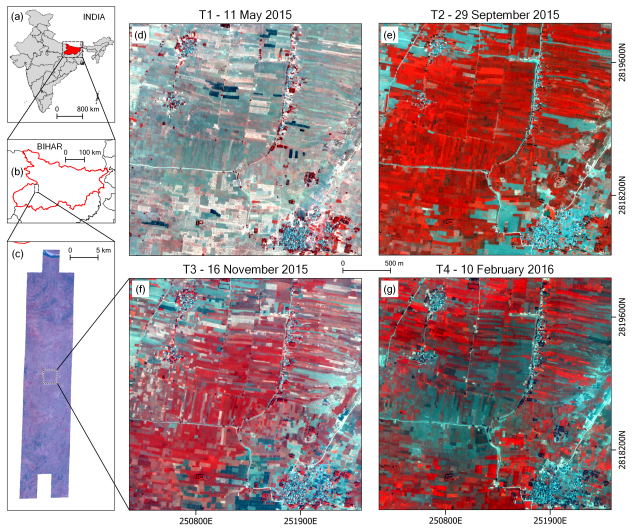
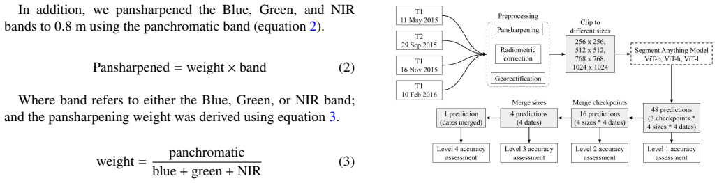
Accurate mapping of agricultural field boundaries is crucial for enhancing outcomes like precision agriculture, crop monitoring, and yield estimation. However, extracting these boundaries from satellite images is challenging, especially for smallholder farms and data-scarce environments. This study explores the Segment Anything Model (SAM) to delineate agricultural field boundaries in Bihar, India, using 2-meter resolution SkySat imagery without additional training. We evaluate SAM's performance across three model checkpoints, various input sizes, multi-date satellite images, and edge-enhanced imagery. Our results show that SAM correctly identifies about 58% of field boundaries, comparable to other approaches requiring extensive training data. Using different input image sizes improves accuracy, with the most significant improvement observed when using multi-date satellite images. This work establishes proof of concept for using SAM and maximizing its potential in agricultural field boundary mapping. Our work highlights SAM's potential in delineating agriculture field boundary in training-data scarce settings to enable a wide range of agriculture related analysis.
Editorial analysis
A structured set of objections, weighed in public.
Referee Report
Summary. The paper investigates applying the Segment Anything Model (SAM) to delineate smallholder agricultural field boundaries from 2 m SkySat imagery in Bihar, India, without any task-specific training or fine-tuning. It reports results across three SAM checkpoints, varying input sizes, multi-date imagery, and edge-enhanced inputs, claiming that SAM correctly identifies about 58% of field boundaries and performs comparably to supervised methods that require extensive labeled data. The work positions this as a proof-of-concept for foundation models in data-scarce agricultural mapping.
Significance. If the 58% figure is supported by a clearly documented, independent ground-truth dataset and a reproducible evaluation protocol, the result would be significant for remote-sensing applications in smallholder systems: it would show that a general-purpose segmentation foundation model can deliver usable boundary maps without the labeling burden that currently limits supervised approaches in many regions.
major comments (1)
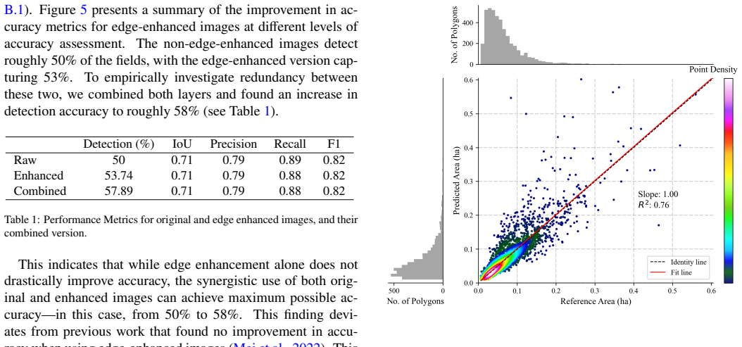
- [Results] Results section (and abstract): The headline claim that SAM 'correctly identifies about 58% of field boundaries' is presented without any accompanying information on (a) the size and source of the ground-truth dataset, (b) the precise boundary-matching rule or tolerance used to declare a detection correct, or (c) quantitative baselines and error bars. This information is load-bearing for both the 58% number and the comparability statement; its absence prevents verification that the evaluation is independent of SAM outputs and that the metric is not inadvertently favorable to SAM's output style.
minor comments (2)
- [Abstract] The abstract and introduction would benefit from a short statement of the total number of images and fields evaluated.
- [Methods] Notation for the three SAM checkpoints (e.g., ViT-H, ViT-L, ViT-B) should be introduced consistently when first mentioned.
Simulated Author's Rebuttal
We thank the referee for the constructive feedback on our manuscript. We agree that the evaluation details supporting the 58% figure require explicit documentation to allow independent verification, and we will revise the manuscript to address this.
read point-by-point responses
-
Referee: [Results] Results section (and abstract): The headline claim that SAM 'correctly identifies about 58% of field boundaries' is presented without any accompanying information on (a) the size and source of the ground-truth dataset, (b) the precise boundary-matching rule or tolerance used to declare a detection correct, or (c) quantitative baselines and error bars. This information is load-bearing for both the 58% number and the comparability statement; its absence prevents verification that the evaluation is independent of SAM outputs and that the metric is not inadvertently favorable to SAM's output style.
Authors: We acknowledge that the current version of the manuscript does not provide sufficient detail on these points in the Results section or abstract. In the revised manuscript we will add a clear description of (a) the ground-truth dataset (its size, collection method, and source, collected independently of any SAM outputs), (b) the exact boundary-matching protocol and tolerance used to score a detection as correct, and (c) quantitative comparisons to supervised baselines together with error bars or confidence intervals. These additions will be placed in the Methods and Results sections to ensure the 58% figure and comparability claims are fully reproducible and verifiable. revision: yes
Circularity Check
No circularity: empirical report with no derivations or fitted predictions
full rationale
The paper is an empirical evaluation of the Segment Anything Model on satellite imagery for field boundary detection, reporting a measured accuracy of ~58% without any equations, parameter fitting, or claimed first-principles derivations. The central claim is a direct performance observation on external imagery rather than a quantity constructed from quantities defined inside the paper. No self-citation chains, ansatzes, or uniqueness theorems are invoked to support a derivation, so the result does not reduce to its own inputs by construction.
Axiom & Free-Parameter Ledger
axioms (1)
- domain assumption SAM generalizes zero-shot to satellite imagery of agricultural fields
Lean theorems connected to this paper
-
IndisputableMonolith/Cost/FunctionalEquation.leanwashburn_uniqueness_aczel unclear?
unclearRelation between the paper passage and the cited Recognition theorem.
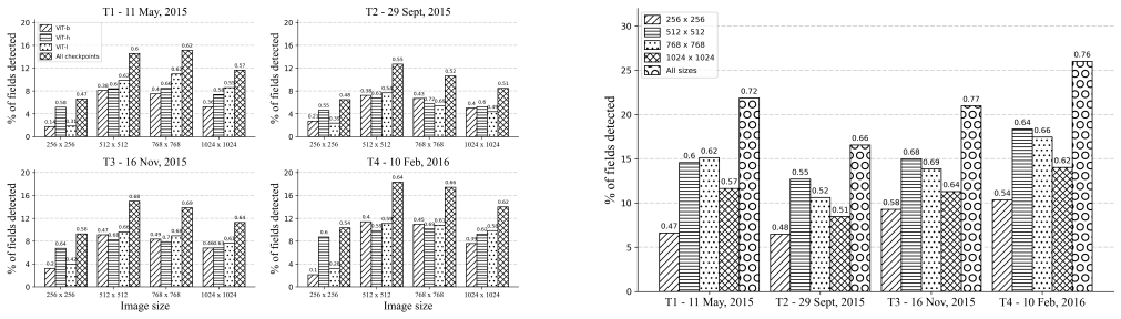
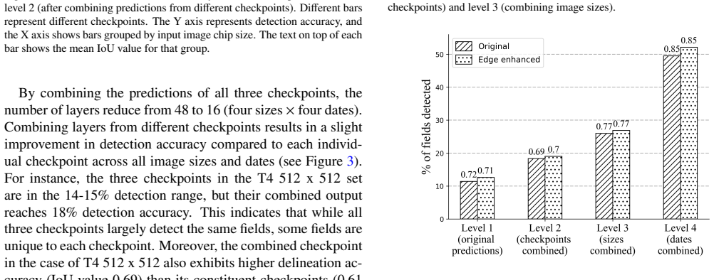
We use the Intersection Over Union (IoU) metric... detection accuracy... proportion of predicted fields with an IoU value greater than 0.5... delineation accuracy... mean IoU value
-
IndisputableMonolith/Foundation/RealityFromDistinction.leanreality_from_one_distinction unclear?
unclearRelation between the paper passage and the cited Recognition theorem.
Our results show that SAM correctly identifies about 58% of field boundaries
What do these tags mean?
- matches
- The paper's claim is directly supported by a theorem in the formal canon.
- supports
- The theorem supports part of the paper's argument, but the paper may add assumptions or extra steps.
- extends
- The paper goes beyond the formal theorem; the theorem is a base layer rather than the whole result.
- uses
- The paper appears to rely on the theorem as machinery.
- contradicts
- The paper's claim conflicts with a theorem or certificate in the canon.
- unclear
- Pith found a possible connection, but the passage is too broad, indirect, or ambiguous to say the theorem truly supports the claim.
Reference graph
Works this paper leans on
-
[1]
doi: https: //doi.org/10.1016/ j.rse.2016.03.010
ISSN 0034-4257. doi: https: //doi.org/10.1016/ j.rse.2016.03.010. URL https://www.sciencedirect.com/science/ article/pii/S0034425716301031. Lyndon D. Estes, Su Ye, Lei Song, Boka Luo, J. Ronald Eastman, Zhenhua Meng, Qi Zhang, Dennis McRitchie, Stephanie R. Debats, Justus Muhando, Angeline H. Amukoa, Brian W. Kaloo, Jackson Makuru, Ben K. Mbatia, Isaac M....
work page 2016
-
[2]
ISSN 2624-8212. doi: 10.3389 /frai.2021. 744863. URL https://www.frontiersin.org/articles/10.3389/ frai.2021.744863. Ashley Fernandez and Swaraj Dube. Core building blocks: Next gen geo spatial GPT application,
-
[3]
URL http://arxiv.org/abs/2310.11029. Artur Gafurov. Automated Mapping of Cropland Boundaries Using Deep Neu- ral Networks. AgriEngineering, 5(3):1568–1580, September
-
[4]
doi: 10.1016 /j.foodres.2014.03.015
ISSN 0963-9969. doi: 10.1016 /j.foodres.2014.03.015. URL https://www. sciencedirect.com/science/article/pii/S0963996914001732. Angel Garcia-Pedrero, Consuelo Gonzalo-Martin, Mario Lillo-Saavedra, and Dionisio Rodr´ıguez-Esparrag´on. The Outlining of Agricultural Plots Based on Spatiotemporal Consensus Segmentation. Remote Sensing, 10(12):1991, December
work page 2014
-
[5]
ISSN 2072-4292. doi: 10.3390 /rs10121991. URL http: //www.mdpi.com/2072-4292/10/12/1991. Johannes Jakubik, Sujit Roy, C. E. Phillips, Paolo Fraccaro, Denys Godwin, Bianca Zadrozny, Daniela Szwarcman, Carlos Gomes, Gabby Nyirjesy, Blair Edwards, Daiki Kimura, Naomi Simumba, Linsong Chu, S. Karthik Mukkavilli, Devyani Lambhate, Kamal Das, Ranjini Bangalore,...
work page 2072
-
[6]
Available: https://arxiv.org/abs/2310.18660
URL http://arxiv. org/abs/2310.18660. Alexander Kirillov, Eric Mintun, Nikhila Ravi, Hanzi Mao, Chloe Rolland, Laura Gustafson, Tete Xiao, Spencer Whitehead, Alexander C. Berg, Wan- Yen Lo, Piotr Doll´ar, and Ross Girshick. Segment anything,
-
[7]
doi: 10.1080/17538947.2023.2278895. URL https://doi.org/10.1080/ 17538947.2023.2278895. Weiye Mei, Haoyu Wang, David Fouhey, Weiqi Zhou, Isabella Hinks, Josh M. Gray, Derek Van Berkel, and Meha Jain. Using deep learning and very-high- resolution imagery to map smallholder field boundaries.Remote Sensing, 14 (13),
-
[8]
ISSN 2072-4292. doi: 10.3390 /rs14133046. Heather C North, David Pairman, and Stella E Belliss. Boundary delineation of agricultural fields in multitemporal satellite imagery. IEEE Journal of Selected Topics in Applied Earth Observations and Remote Sensing , 12(1): 237–251,
work page 2072
-
[9]
doi: 10.1038 /s41467-021-24638-z
ISSN 2041-1723. doi: 10.1038 /s41467-021-24638-z. URL https://www.nature.com/ articles/s41467-021-24638-z . Publisher: Nature Publishing Group. RB Singh, Praduman Kumar, T Woodhead, et al. Smallholder farmers in india: Food security and agricultural policy. Smallholder farmers in India: Food 7 security and agricultural policy,
work page 2041
-
[10]
ISSN 2072-4292. doi: 10.3390/rs13040722. URL https://www.mdpi.com/2072-4292/13/4/
-
[11]
ISSN 2072-4292. doi: 10.3390 / rs12071205. URL https://www.mdpi.com/2072-4292/12/7/1205. Franc ¸ois Waldner and Foivos I. Diakogiannis. Deep learning on edge: Ex- tracting field boundaries from satellite images with a convolutional neu- ral network. Remote Sensing of Environment , 245:111741, August
work page 2072
-
[12]
doi: 10.1016 /j.rse.2020.111741
ISSN 0034-4257. doi: 10.1016 /j.rse.2020.111741. URL https://www. sciencedirect.com/science/article/pii/S0034425720301115. Mo Wang, Jing Wang, Yunpeng Cui, Juan Liu, and Li Chen. Agricul- tural Field Boundary Delineation with Satellite Image Segmentation for High-Resolution Crop Mapping: A Case Study of Rice Paddy. Agron- omy, 12(10):2342, September 2022a...
-
[13]
URL https://doi.org/10.1080/17538947.2024.2353122. M. Weiss, F. Jacob, and G. Duveiller. Remote sensing for agricultural applications: A meta-review. Remote Sensing of Environment , 236: 111402,
-
[14]
doi: https: //doi.org/10.1016/j.rse.2019
ISSN 0034-4257. doi: https: //doi.org/10.1016/j.rse.2019. 111402. URL https://www.sciencedirect.com/science/article/ pii/S0034425719304213. Qiusheng Wu and Lucas Prado Osco. samgeo: A python package for seg- menting geospatial data with the segment anything model (sam). Journal of Open Source Software, 8(89):5663,
-
[15]
URL https://doi.org/10.21105/joss.05663
doi: 10.21105 /joss.05663. URL https://doi.org/10.21105/joss.05663. Ruoyu Yang, Zia U. Ahmed, Urs C. Schulthess, Mustafa Kamal, and Rahul Rai. Detecting functional field units from satellite images in smallholder farming systems using a deep learning based computer vision approach: A case study from bangladesh. Remote Sensing Applications: Society and Env...
-
[16]
doi: https: //doi.org/ 10.1016/j.rsase.2020.100413
ISSN 2352-9385. doi: https: //doi.org/ 10.1016/j.rsase.2020.100413. URL https://www.sciencedirect.com/ science/article/pii/S2352938519301831. Peng Zhang, Shougeng Hu, Weidong Li, and Chuanrong Zhang. Parcel-level mapping of crops in a smallholder agricultural area: A case of central china using single-temporal vhsr imagery. Computers and Electronics in Ag...
-
[17]
URL http://arxiv.org/abs/2307.07930. 8 A. Data creation and pre-processing Figure A.1: Polygons in the adjacent tiles before merging and after merging. Workflow described in Section 2.9. Figure A.2: Manually generated ground truth agricultural field boundary polygons. Figure A.3: Image showing the entire image chip (size 256 by
discussion (0)
Sign in with ORCID, Apple, or X to comment. Anyone can read and Pith papers without signing in.