REVIEW 4 major objections 5 minor 48 references
Real-Time Metric-Semantic Mapping for Autonomous Navigation in Outdoor Environments
T0 review · 4 major / 5 minor · reviewed 2026-08-12 · deepseek-v4-flash
Pith's one-line read This paper claims that a GPU-accelerated metric-semantic mapping system can build a global labeled mesh map of outdoor scenes while processing each LiDAR frame in under 7 ms, and that the map can drive real point-to-point navigation.
desk verdict Real systems integration with public code and solid mapping benchmarks, but the sub-7ms timing claim omits mesh generation and segmentation inference, so the headline is overstated. read the letter →
The pith
A machine-rendered reading of the paper's core claim, the machinery that carries it, and where it could break.
The reading
What carries the argument
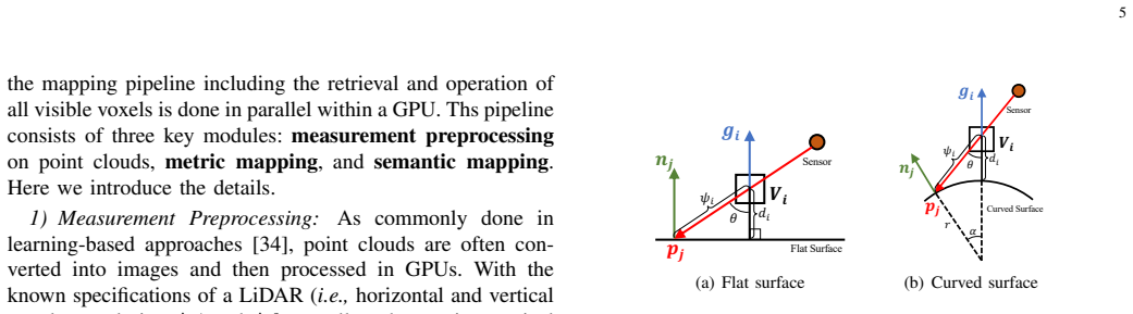
The load-bearing object is the implicit TSDF voxel map with per-voxel semantics. A voxel stores a truncated signed distance, a weight, a gradient, and a probability distribution over semantic labels; the signed distance is updated with a non-projective distance that uses the local surface normal and gradient to approximate the true distance, and the semantic distribution is updated with a recursive Bayesian filter as new labeled images arrive. The whole update, including visible-voxel retrieval by ray casting, runs in parallel on the GPU inside a two-level voxel hash. This representation is what connects sensing to navigation: marching cubes turns the TSDF into a labeled mesh, and geometric properties of that mesh (height difference, steepness, roughness) plus semantic labels define the traversable region used for planning.
What would settle it
On a long trajectory that revisits a surveyed area, run the pipeline with loop closure disabled and compare the global mesh to a survey-grade point cloud: if the reconstruction error grows past the reported tens-of-centimeters level or the revisited surfaces split into visibly doubled walls, the claim of a consistent global metric-semantic map is falsified for long-range operation.
Extended reading notes
Core claim
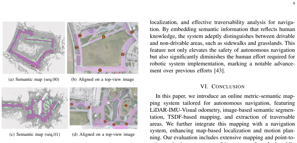
The central discovery is a GPU-accelerated pipeline whose metric-semantic mapping core is fast enough to keep pace with LiDAR frame rates regardless of map size, and whose representation is rich enough to support navigation. The system represents the environment as a truncated signed distance field (TSDF) over voxels stored in a two-level GPU hash structure. For each incoming scan it ray-casts visible voxels in parallel, updates distance using a non-projective distance that approximates true surface distance from local normals and gradients, and fuses pixel-wise semantic probabilities from a CNN into a per-voxel discrete distribution via a recursive Bayesian update. Marching cubes then extracts a global mesh whose vertices carry the most probable label. The authors show that the non-projective distance improves reconstruction error and Chamfer distance over projective baselines, and that the Bayesian update raises semantic mIoU and accuracy. On an RTX 3080Ti the mapping modules take 1.4–6.8 ms per frame across all evaluated sequences, and the resulting traversable-region map lets a real vehicle plan and follow collision-free paths on campus without entering grassland or sidewalks.
Load-bearing premise
The mapping stays globally consistent only if the LiDAR-visual-inertial odometry remains accurate over the whole trajectory, because the system has no loop closure; the paper's own conclusion says drift accumulates over time and would need submap or mesh-deformation correction.
Editorial extensions
If this is right
- At LiDAR frame rates of 10 Hz or higher, the 1.4–6.8 ms per-frame mapping cost leaves most of the compute budget free for segmentation, planning, and control on a desktop GPU.
- Semantic labels let a planner distinguish visually and geometrically similar surfaces, so paths can be restricted to roads while excluding sidewalks and grass, exactly as the campus demonstrations show.
- The map doubles as a global prior: extracted mesh vertices supply the point cloud for map-based localization, and the traversable subset projects to a 2D occupancy grid for hybrid A* planning.
- Repeated views improve label quality because voxel probabilities are fused with a recursive Bayesian update, so the same sensor passes produce a more consistent semantic mesh over time.
- On embedded hardware (Jetson ORIN) the same pipeline runs at 11.5–34.4 ms per frame, suggesting the approach can move from desktop to onboard deployment.
Reading between the lines
- The 7 ms figure covers metric and semantic map updates inside the mapping module; an end-to-end latency budget would also include CNN segmentation, state estimation, and mesh generation, so the full system's real-time margin is smaller than the headline number implies.
- Because traversability is defined by thresholds and a label-to-drivability policy, the mapping core could be reused for legged robots, excavators, or aerial vehicles by changing only those rules.
- The paper's own limitation note predicts odometry drift without loop closure; extending the system to city-scale or kilometer-long missions would likely require submap-based correction, and the current frame budget appears to leave room for such an addition.
- A direct test of the semantic fusion benefit would be to feed progressively noisier segmentation outputs and measure final map mIoU versus the number of observations; the reported comparison with and without the Bayesian filter suggests fusion should keep the map stable against single-frame mislabels.
Editorial analysis
A structured set of objections, weighed in public.
Referee Report
Summary. The paper presents a GPU-accelerated metric-semantic mapping system for outdoor environments, built on a TSDF-based volumetric representation with LiDAR-visual-inertial odometry, image-based semantic segmentation with Bayesian fusion, and mesh-based traversability analysis for navigation. The authors evaluate reconstruction accuracy, semantic quality, and processing time on public datasets (SemanticKITTI, SemanticUSL, FusionPortable) and demonstrate two campus point-to-point navigation experiments with a ground vehicle. The central claim is that the mapping pipeline processes each LiDAR frame in under 7 ms on a desktop GPU regardless of scenario scale, and that the resulting global metric-semantic mesh map supports real-world autonomous navigation.
Significance. If the central claims hold, this is a valuable engineering contribution: it combines a recent GPU TSDF mapping library (NvBlox) with semantic fusion and traversability analysis in an integrated, publicly released system. The paper reports extensive experiments across 24 sequences, uses external ground-truth datasets for reconstruction and semantic metrics, and includes real-world navigation demonstrations, which are strengths. The non-projective distance formulation is evaluated against an ablative variant (Ours-Proj) and a CPU baseline (VoxField), giving some support for the algorithmic improvement. However, the headline real-time claim is narrower than stated in the abstract, and the timing comparisons against CPU baselines do not isolate the algorithmic gain from hardware acceleration. The navigation experiments are qualitative and preliminary, but the paper's primary contribution is the mapping system, so the main assessment rests on the mapping claims.
major comments (4)
- [Abstract, §V.C.5, Table IV] The abstract claims 'frame processing taking less than 7ms, regardless of scenario scale,' but the reported timing in Table IV covers only normal image estimation (0.2 ms), metric mapping (1.0 ms), and semantic mapping (1.0 ms). Mesh generation, which the paper itself lists as part of the mapping pipeline and which takes 32.3 ms on the 3080Ti, is excluded from the 'frame processing' figure, and the semantic segmentation network's inference time is not reported anywhere. Since the semantic map cannot be updated without segmentation and the global mesh is the output described in the abstract, the end-to-end per-frame cost of the mapping system is not substantiated. The authors should either report the full per-frame pipeline latency (including segmentation and mesh updates scheduled per frame) or clearly restrict the 'less than 7 ms' claim to the subset of modules listed in Table IV.
- [§V.C.5, Table II] The phrase 'regardless of scenario scale' is stronger than the evidence supports. Table II notes that SemanticKITTI sequences 00, 02, and 08 were run with a coarser voxel size (0.3 m instead of 0.25 m) because GPU memory could not store all voxels at the finer resolution. Thus the 'scale-independent' timing is achieved conditionally, at the cost of reduced map resolution on the largest scenarios. The paper should qualify the scale-invariance claim to state that it holds when voxel resolution is adjusted to fit available GPU memory.
- [§V.C.2, Table IV] The timing comparison is between a GPU implementation (Ours) and CPU implementations (VoxBlox, VoxField). The acceleration ratios reported in Table IV (e.g., ×124.2 for metric mapping) conflate algorithmic differences with hardware differences, so they do not demonstrate that the proposed algorithmic choices themselves are faster. The algorithmic contribution is better supported by the reconstruction metrics (RE, CD) and the ablations Ours-Proj and Ours-wo-Bay. The paper should explicitly acknowledge this confound, or provide a CPU implementation of the proposed pipeline (or a GPU implementation of the baselines) to isolate algorithmic speed gains.
- [§VI, Conclusion] The paper acknowledges in the Conclusion that 'the absence of loop correction introduces drift over time.' This is an honest limitation, but it directly affects the claim of producing a 'global metric-semantic mesh map' for large-scale outdoor environments. The presented evaluations are on sequences without long-duration drift characterization, so the consistency of the global map over extended trajectories is not demonstrated. The authors should either add a quantitative drift analysis or explicitly scope the global-map claim to the odometry accuracy achieved in the reported experiments.
minor comments (5)
- [Throughout] There are numerous typographical and grammatical errors, such as 'execuate' (Abstract), 'pedestrains' (Introduction), 'reprense' (§III-B), 'proecssing' (Fig. 2), 'kinomatic' (§IV-D), 'socres' (§V-C3), and 'via.' (Fig. 9 caption). These should be corrected in a thorough language edit.
- [§IV-D1] The definitions of 'height difference' and 'roughness' are imprecise: 'height difference' is written as arg max of Euclidean distance over a ball, which is not a height difference unless the ball is aligned to gravity; 'roughness' is defined as an average of normals, which does not measure irregularity as described in the text. Clarify these formulas and their intended geometric meaning.
- [§IV-B] The semantic segmentation network is referenced only via [33] and a brief description. Since the network's segmentation quality and inference latency are central to the semantic mapping performance, a more detailed description (architecture, input resolution, pre-training details) and at least the inference time per image should be provided.
- [§V-C, Table III] The mIoU and Acc metrics are reported only for SemanticKITTI and SemanticUSL, and not for FusionPortable due to missing annotations. The paper states this, but the discussion of semantic results in the text does not consistently separate these datasets; make the scope of semantic evaluation explicit in the main text.
- [§V-D2] The navigation experiments are qualitative: two goal-point tests with a single vehicle, no quantitative success metrics, timing, or comparison with a baseline navigation approach. While these experiments are supplementary to the mapping claims, the paper should either provide quantitative navigation results or clearly label this as a feasibility demonstration.
Circularity Check
No circularity: quantitative claims are benchmarked against independent public datasets and code-released baselines; cited self-work is not load-bearing.
full rationale
No significant circularity found. The paper's central quantitative claims—mapping accuracy and computation time—are evaluated against independent public datasets (SemanticKITTI, SemanticUSL, FusionPortable) with ground-truth maps and labels, and compared against external baselines (VoxBlox, VoxField). The timing breakdown in Tables III and IV is an empirical measurement with a stated scope; although the abstract's '<7 ms' claim excludes mesh generation and the semantic segmentation network's inference time, that is a scope or overstatement issue rather than an equation-level circularity. The segmentation network is trained on a self-collected campus dataset and then used in campus navigation demonstrations, but this is a domain-match/generalization concern, not a definitional reduction: the mapping accuracy is not derived from the network's training labels, and navigation success is demonstrated qualitatively. Self-citations such as FusionPortable [7] and PALoc [42] are dataset and localization-tool citations; they do not carry the proof burden of the mapping claim. No parameter is fitted to a target quantity and then renamed as a prediction, no uniqueness theorem is imported from the authors' prior work, and no ansatz is smuggled in via citation. The non-projective distance formulation is attributed to and benchmarked against VoxField [37], which is independent support rather than circular reliance.
Assumptions & free parameters
free parameters (5)
- Voxel size ν =
0.25 m or 0.3 m
- Truncation distance τ =
5ν
- Traversability thresholds thd, tv, tr =
0.6 m, 20°, 30°
- RGB point age cutoff =
3 s
- Alpha threshold in Eq. (4) =
not specified
assumptions (5)
- domain assumption Per-pixel segmentation probabilities are calibrated enough to be used as likelihoods in the recursive Bayesian update (Eq. 6).
- domain assumption Ground-truth point clouds and labels in SemanticKITTI, SemanticUSL, and FusionPortable are accurate for evaluating reconstruction and semantic accuracy.
- domain assumption The checkerboard-based spatial calibration provides sufficiently accurate LiDAR-camera extrinsics for semantic label projection.
- domain assumption The robot's kinematic constraints and the hand-set traversability thresholds transfer to the test vehicle and environment.
- standard math TSDF fusion and marching cubes are valid for surface reconstruction from the given depth images.
Cite this review
Pith. "Pith review of Real-Time Metric-Semantic Mapping for Autonomous Navigation in Outdoor Environments." pith.science (2026). https://pith.science/paper/QKCKKX5V
@misc{pith2026241200291,
  author       = {Pith},
  title        = {Pith review of: Real-Time Metric-Semantic Mapping for Autonomous Navigation in Outdoor Environments},
  year         = {2026},
  howpublished = {\url{https://pith.science/paper/QKCKKX5V}},
  note         = {Machine review of arXiv:2412.00291}
}
read the original abstract
The creation of a metric-semantic map, which encodes human-prior knowledge, represents a high-level abstraction of environments. However, constructing such a map poses challenges related to the fusion of multi-modal sensor data, the attainment of real-time mapping performance, and the preservation of structural and semantic information consistency. In this paper, we introduce an online metric-semantic mapping system that utilizes LiDAR-Visual-Inertial sensing to generate a global metric-semantic mesh map of large-scale outdoor environments. Leveraging GPU acceleration, our mapping process achieves exceptional speed, with frame processing taking less than 7ms, regardless of scenario scale. Furthermore, we seamlessly integrate the resultant map into a real-world navigation system, enabling metric-semantic-based terrain assessment and autonomous point-to-point navigation within a campus environment. Through extensive experiments conducted on both publicly available and self-collected datasets comprising 24 sequences, we demonstrate the effectiveness of our mapping and navigation methodologies. Code has been publicly released: https://github.com/gogojjh/cobra
Figures


Figures from the paper (6 more)




Reference graph
Works this paper leans on
- [1]
-
[2]
Kimera: From SLAM to spatial perception with 3d dynamic scene graphs,
A. Rosinol, A. Violette, M. Abate, N. Hughes, Y . Chang, J. Shi, A. Gupta, and L. Carlone, “Kimera: From SLAM to spatial perception with 3d dynamic scene graphs,” The International Journal of Robotics Research , vol. 40, no. 12-14, pp. 1510–1546, 2021
work page 2021
-
[3]
Neural rrt*: Learning-based optimal path planning,
J. Wang, W. Chi, C. Li, C. Wang, and M. Q.-H. Meng, “Neural rrt*: Learning-based optimal path planning,” IEEE Transactions on Automation Science and Engineer- ing, vol. 17, no. 4, pp. 1748–1758, 2020
work page 2020
-
[4]
nvblox: Gpu- accelerated incremental signed distance field mapping,
A. Millane, H. Oleynikova, E. Wirbel, R. Steiner, V . Ra- masamy, D. Tingdahl, and R. Siegwart, “nvblox: Gpu- accelerated incremental signed distance field mapping,” arXiv preprint arXiv:2311.00626 , 2023. 10 [m]0.0 0.4 ≥ 0.8 (a) [deg]0.0 22.5 ≥45.0 (b) [deg]0.0 22.5 ≥45.0 (c) (d) Grass (e) [m]0.0 0.4 ≥ 0.8 (f) [deg]0.0 22.5 ≥ 45.0 (g) [deg]0.0 22.5 ≥ 45....
arXiv 2023
-
[5]
A benchmark for LiDAR-based panoptic segmentation based on KITTI,
J. Behley, A. Milioto, and C. Stachniss, “A benchmark for LiDAR-based panoptic segmentation based on KITTI,” in 2021 IEEE International Conference on Robotics and Automation (ICRA). IEEE, 2021, pp. 13 596–13 603
work page 2021
-
[6]
LiDARNet: A boundary- aware domain adaptation model for point cloud semantic segmentation,
P. Jiang and S. Saripalli, “LiDARNet: A boundary- aware domain adaptation model for point cloud semantic segmentation,” in 2021 IEEE International Conference on Robotics and Automation (ICRA) . IEEE, 2021, pp. 2457–2464
work page 2021
-
[7]
J. Jiao, H. Wei, T. Hu, X. Hu, Y . Zhu, Z. He, J. Wu, J. Yu, X. Xie, H. Huang et al., “FusionPortable: A multi- sensor campus-scene dataset for evaluation of localiza- tion and mapping accuracy on diverse platforms,” in2022 IEEE/RSJ International Conference on Intelligent Robots and Systems (IROS) . IEEE, 2022, pp. 3851–3856
work page 2022
-
[8]
SLAM++: Simultaneous localisation and mapping at the level of objects,
R. F. Salas-Moreno, R. A. Newcombe, H. Strasdat, P. H. Kelly, and A. J. Davison, “SLAM++: Simultaneous localisation and mapping at the level of objects,” in Proceedings of the IEEE conference on computer vision and pattern recognition , 2013, pp. 1352–1359
work page 2013
Show all 48 references
-
[9]
Kinectfusion: Real-time dense sur- face mapping and tracking,
R. A. Newcombe, S. Izadi, O. Hilliges, D. Molyneaux, D. Kim, A. J. Davison, P. Kohi, J. Shotton, S. Hodges, and A. Fitzgibbon, “Kinectfusion: Real-time dense sur- face mapping and tracking,” in 2011 10th IEEE interna- tional symposium on mixed and augmented reality. Ieee, 2011...
2011
-
[10]
Semanticfusion: Dense 3d semantic mapping with convolutional neural networks,
J. McCormac, A. Handa, A. Davison, and S. Leuteneg- ger, “Semanticfusion: Dense 3d semantic mapping with convolutional neural networks,” in 2017 IEEE Interna- tional Conference on Robotics and automation (ICRA) . IEEE, 2017, pp. 4628–4635
2017
-
[11]
Elasticfusion: Dense slam without a pose graph
T. Whelan, S. Leutenegger, R. Salas-Moreno, B. Glocker, and A. Davison, “Elasticfusion: Dense slam without a pose graph.” Robotics: Science and Systems, 2015
2015
-
[12]
Maskfusion: Real- time recognition, tracking and reconstruction of multiple moving objects,
M. Runz, M. Buffier, and L. Agapito, “Maskfusion: Real- time recognition, tracking and reconstruction of multiple moving objects,” in 2018 IEEE International Symposium on Mixed and Augmented Reality (ISMAR). IEEE, 2018, pp. 10–20
2018
-
[13]
V olumetric instance- aware semantic mapping and 3d object discovery,
M. Grinvald, F. Furrer, T. Novkovic, J. J. Chung, C. Ca- dena, R. Siegwart, and J. Nieto, “V olumetric instance- aware semantic mapping and 3d object discovery,” IEEE Robotics and Automation Letters, vol. 4, no. 3, pp. 3037– 3044, 2019. 11
2019
-
[14]
V oxblox: Incremental 3d euclidean signed distance fields for on-board mav planning,
H. Oleynikova, Z. Taylor, M. Fehr, R. Siegwart, and J. Nieto, “V oxblox: Incremental 3d euclidean signed distance fields for on-board mav planning,” in 2017 IEEE/RSJ International Conference on Intelligent Robots and Systems (IROS) . IEEE, 2017, pp. 1366–1373
2017
-
[15]
Bayesian spatial kernel smoothing for scalable dense semantic mapping,
L. Gan, R. Zhang, J. W. Grizzle, R. M. Eustice, and M. Ghaffari, “Bayesian spatial kernel smoothing for scalable dense semantic mapping,” IEEE Robotics and Automation Letters, vol. 5, no. 2, pp. 790–797, 2020
2020
-
[16]
Learning- aided 3-d occupancy mapping with bayesian general- ized kernel inference,
K. Doherty, T. Shan, J. Wang, and B. Englot, “Learning- aided 3-d occupancy mapping with bayesian general- ized kernel inference,” IEEE Transactions on Robotics , vol. 35, no. 4, pp. 953–966, 2019
2019
-
[17]
Sni-slam: Semantic neural implicit slam,
S. Zhu, G. Wang, H. Blum, J. Liu, L. Song, M. Pollefeys, and H. Wang, “Sni-slam: Semantic neural implicit slam,” arXiv preprint arXiv:2311.11016 , 2023
2023 arXiv
-
[18]
Nice-SLAM: Neural implicit scalable encoding for slam,
Z. Zhu, S. Peng, V . Larsson, W. Xu, H. Bao, Z. Cui, M. R. Oswald, and M. Pollefeys, “Nice-SLAM: Neural implicit scalable encoding for slam,” in Proceedings of the IEEE/CVF Conference on Computer Vision and Pattern Recognition, 2022, pp. 12 786–12 796
2022
-
[19]
Robust odometry and mapping for multi-lidar systems with online extrinsic calibration,
J. Jiao, H. Ye, Y . Zhu, and M. Liu, “Robust odometry and mapping for multi-lidar systems with online extrinsic calibration,” IEEE Transactions on Robotics , vol. 38, no. 1, pp. 351–371, 2021
2021
-
[20]
Immesh: An immediate lidar localiza- tion and meshing framework,
J. Lin, C. Yuan, Y . Cai, H. Li, Y . Ren, Y . Zou, X. Hong, and F. Zhang, “Immesh: An immediate lidar localiza- tion and meshing framework,” IEEE Transactions on Robotics, 2023
2023
-
[21]
Continuous shortest path vector field navigation on 3d triangular meshes for mobile robots,
S. P ¨utz, T. Wiemann, M. K. Piening, and J. Hertzberg, “Continuous shortest path vector field navigation on 3d triangular meshes for mobile robots,” in 2021 IEEE International Conference on Robotics and Automation (ICRA). IEEE, 2021, pp. 2256–2263
2021
-
[22]
Panoptic multi-TSDFs: a flexible representation for online multi- resolution volumetric mapping and long-term dynamic scene consistency,
L. Schmid, J. Delmerico, J. L. Sch ¨onberger, J. Nieto, M. Pollefeys, R. Siegwart, and C. Cadena, “Panoptic multi-TSDFs: a flexible representation for online multi- resolution volumetric mapping and long-term dynamic scene consistency,” in 2022 International Conference on Robo...
2022
-
[23]
Real-time neural dense elevation mapping for urban terrain with uncertainty estimations,
B. Yang, Q. Zhang, R. Geng, L. Wang, and M. Liu, “Real-time neural dense elevation mapping for urban terrain with uncertainty estimations,” IEEE Robotics and Automation Letters, vol. 8, no. 2, pp. 696–703, 2022
2022
-
[24]
Multitask learning for scalable and dense multilayer bayesian map inference,
L. Gan, Y . Kim, J. W. Grizzle, J. M. Walls, A. Kim, R. M. Eustice, and M. Ghaffari, “Multitask learning for scalable and dense multilayer bayesian map inference,” IEEE Transactions on Robotics , 2022
2022
-
[25]
Deeplab: Semantic image segmen- tation with deep convolutional nets, atrous convolution, and fully connected crfs,
L.-C. Chen, G. Papandreou, I. Kokkinos, K. Murphy, and A. L. Yuille, “Deeplab: Semantic image segmen- tation with deep convolutional nets, atrous convolution, and fully connected crfs,” IEEE transactions on pattern analysis and machine intelligence , vol. 40, no. 4, pp. 834–848, 2017
2017
-
[26]
Elevation mapping for locomotion and navigation using gpu,
T. Miki, L. Wellhausen, R. Grandia, F. Jenelten, T. Homberger, and M. Hutter, “Elevation mapping for locomotion and navigation using gpu,” in 2022 IEEE/RSJ International Conference on Intelligent Robots and Sys- tems (IROS). IEEE, 2022, pp. 2273–2280
2022
-
[27]
TNS: Terrain traversability mapping and navigation system for autonomous excavators,
T. Guan, Z. He, R. Song, D. Manocha, and L. Zhang, “TNS: Terrain traversability mapping and navigation system for autonomous excavators,” arXiv preprint arXiv:2109.06250, 2021
2021 arXiv
-
[28]
Unified temporal and spatial calibration for multi-sensor systems,
P. Furgale, J. Rehder, and R. Siegwart, “Unified temporal and spatial calibration for multi-sensor systems,” in 2013 IEEE/RSJ International Conference on Intelligent Robots and Systems. IEEE, 2013, pp. 1280–1286
2013
-
[29]
LCE-Calib: Automatic lidar-frame/event camera extrinsic calibration with a globally optimal solution,
J. Jiao, F. Chen, H. Wei, J. Wu, and M. Liu, “LCE-Calib: Automatic lidar-frame/event camera extrinsic calibration with a globally optimal solution,” IEEE/ASME Transac- tions on Mechatronics , 2023
2023
-
[30]
R3live: A robust, real-time, rgb- colored, lidar-inertial-visual tightly-coupled state esti- mation and mapping package,
J. Lin and F. Zhang, “R3live: A robust, real-time, rgb- colored, lidar-inertial-visual tightly-coupled state esti- mation and mapping package,” in 2022 International Conference on Robotics and Automation (ICRA) . IEEE, 2022, pp. 10 672–10 678
2022
-
[31]
Deep high- resolution representation learning for visual recognition,
J. Wang, K. Sun, T. Cheng, B. Jiang, C. Deng, Y . Zhao, D. Liu, Y . Mu, M. Tan, X. Wang et al. , “Deep high- resolution representation learning for visual recognition,” IEEE transactions on pattern analysis and machine in- telligence, vol. 43, no. 10, pp. 3349–3364, 2020
2020
-
[32]
What uncertainties do we need in bayesian deep learning for computer vision?
A. Kendall and Y . Gal, “What uncertainties do we need in bayesian deep learning for computer vision?” Advances in neural information processing systems , vol. 30, 2017
2017
-
[33]
Modeling aleatoric un- certainty for camouflaged object detection,
J. Liu, J. Zhang, and N. Barnes, “Modeling aleatoric un- certainty for camouflaged object detection,” in Proceed- ings of the IEEE/CVF Winter Conference on Applications of Computer Vision , 2022, pp. 1445–1454
2022
-
[34]
Moving object segmentation in 3d lidar data: A learning-based approach exploiting sequential data,
X. Chen, S. Li, B. Mersch, L. Wiesmann, J. Gall, J. Behley, and C. Stachniss, “Moving object segmentation in 3d lidar data: A learning-based approach exploiting sequential data,” IEEE Robotics and Automation Letters , vol. 6, no. 4, pp. 6529–6536, 2021
2021
-
[35]
Real-time 3d reconstruction at scale using voxel hash- ing,
M. Nießner, M. Zollh ¨ofer, S. Izadi, and M. Stamminger, “Real-time 3d reconstruction at scale using voxel hash- ing,” ACM Transactions on Graphics (ToG) , vol. 32, no. 6, pp. 1–11, 2013
2013
-
[36]
stdgpu: Efficient stl-like data structures on the gpu,
P. Stotko, “stdgpu: Efficient stl-like data structures on the gpu,” arXiv preprint arXiv:1908.05936 , 2019
1908 arXiv
-
[37]
V oxfield: Non-projective signed dis- tance fields for online planning and 3d reconstruction,
Y . Pan, Y . Kompis, L. Bartolomei, R. Mascaro, C. Stach- niss, and M. Chli, “V oxfield: Non-projective signed dis- tance fields for online planning and 3d reconstruction,” in 2022 IEEE/RSJ International Conference on Intelligent Robots and Systems (IROS) . IEEE, 2022, pp. 5331– 5338
2022
-
[38]
Kimera: an open-source library for real-time metric- semantic localization and mapping,
A. Rosinol, M. Abate, Y . Chang, and L. Carlone, “Kimera: an open-source library for real-time metric- semantic localization and mapping,” in 2020 IEEE In- ternational Conference on Robotics and Automation (ICRA). IEEE, 2020, pp. 1689–1696
2020
-
[39]
A survey of the marching cubes algorithm,
T. S. Newman and H. Yi, “A survey of the marching cubes algorithm,” Computers & Graphics, vol. 30, no. 5, pp. 854–879, 2006
2006
-
[40]
Visual teach and repeat for long-range rover autonomy,
P. Furgale and T. D. Barfoot, “Visual teach and repeat for long-range rover autonomy,” Journal of field robotics, 12 vol. 27, no. 5, pp. 534–560, 2010
2010
-
[41]
Far planner: Fast, attemptable route planner using dynamic visibility update,
F. Yang, C. Cao, H. Zhu, J. Oh, and J. Zhang, “Far planner: Fast, attemptable route planner using dynamic visibility update,” in 2022 IEEE/RSJ International Con- ference on Intelligent Robots and Systems (IROS). IEEE, 2022, pp. 9–16
2022
-
[42]
Paloc: Advancing slam benchmarking with prior-assisted 6-dof trajectory gener- ation and uncertainty estimation,
X. Hu, L. Zheng, J. Wu, R. Geng, Y . Yu, H. Wei, X. Tang, L. Wang, J. Jiao, and M. Liu, “Paloc: Advancing slam benchmarking with prior-assisted 6-dof trajectory gener- ation and uncertainty estimation,” IEEE/ASME Transac- tions on Mechatronics , pp. 1–12, 2024
2024
-
[43]
The role of the hercules autonomous vehicle during the covid-19 pandemic: An autonomous logistic vehicle for contact- less goods transportation,
T. Liu, Q. hai Liao, L. Gan, F. Ma, J. Cheng, X. Xie, Z. Wang, Y . Chen, Y . Zhu, S. Zhang et al. , “The role of the hercules autonomous vehicle during the covid-19 pandemic: An autonomous logistic vehicle for contact- less goods transportation,” IEEE Robotics & Automation Mag...
2021
-
[44]
The cityscapes dataset for semantic urban scene un- derstanding,
M. Cordts, M. Omran, S. Ramos, T. Rehfeld, M. En- zweiler, R. Benenson, U. Franke, S. Roth, and B. Schiele, “The cityscapes dataset for semantic urban scene un- derstanding,” in Proceedings of the IEEE conference on computer vision and pattern recognition, 2016, pp. 3213– 3223
2016
-
[45]
Occupancy networks: Learning 3d re- construction in function space,
L. Mescheder, M. Oechsle, M. Niemeyer, S. Nowozin, and A. Geiger, “Occupancy networks: Learning 3d re- construction in function space,” in Proceedings of the IEEE/CVF conference on computer vision and pattern recognition, 2019, pp. 4460–4470
2019
-
[46]
Cylinder3d: An effective 3d framework for driving-scene lidar semantic segmentation,
H. Zhou, X. Zhu, X. Song, Y . Ma, Z. Wang, H. Li, and D. Lin, “Cylinder3d: An effective 3d framework for driving-scene lidar semantic segmentation,” arXiv preprint arXiv:2008.01550, 2020
2008 arXiv
-
[47]
Automerge: A framework for map assembling and smoothing in city-scale environments,
P. Yin, S. Zhao, H. Lai, R. Ge, J. Zhang, H. Choset, and S. Scherer, “Automerge: A framework for map assembling and smoothing in city-scale environments,” IEEE Transactions on Robotics , 2023
2023
-
[48]
Kimera-multi: Robust, distributed, dense metric-semantic slam for multi-robot systems,
Y . Tian, Y . Chang, F. H. Arias, C. Nieto-Granda, J. P. How, and L. Carlone, “Kimera-multi: Robust, distributed, dense metric-semantic slam for multi-robot systems,” IEEE Transactions on Robotics , vol. 38, no. 4, 2022
2022
Reviewed August 12, 2026 · model on record in the stance chip above.
Discussion (0). Continue with ORCID to comment.