REVIEW 4 major objections 8 minor 49 references
MDF: Multi-Modal Data Fusion with CNN-Based Object Detection for Enhanced Indoor Localization Using LiDAR-SLAM
T0 review · 4 major / 8 minor · reviewed 2026-08-15 · deepseek-v4-flash
Pith's one-line read CNN-LiDAR-SLAM fuses 2D LiDAR, IMU, and CNN-predicted object landmarks to cut Absolute Trajectory Error by 21.03% over SC-ALOAM and reach 0.25–0.3 m accuracy in corridors without loop closure.
desk verdict The paper's central ATE numbers are mutually contradictory, so its improvement claims collapse despite a plausible system integration. read the letter →
The pith
A machine-rendered reading of the paper's core claim, the machinery that carries it, and where it could break.
The reading
What carries the argument
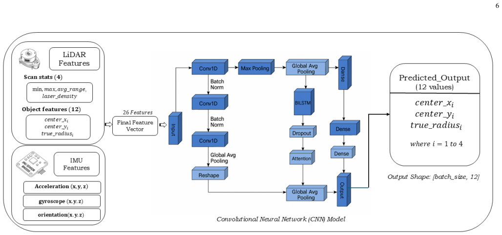
The load-bearing mechanism is the CNN landmark predictor and its coupling equation. The CNN takes a 26-dimensional feature vector (LiDAR scan statistics, preliminary object geometry, and IMU acceleration, gyroscope, and quaternion data), processes it through three 1D convolutional layers with batch normalization, a bidirectional long short-term memory (BiLSTM), and an attention-weighted temporal pooling, and outputs twelve numbers: predicted center coordinates and radii for up to four objects. Those predicted centroids enter the pose correction step of Eq. 23, which minimizes the distance between landmark predictions in consecutive frames to estimate the transformation $\hat{T}$; this correction is iterated together with the iterated extended Kalman filter state update in Eqs. 15–16 and a final pose-graph optimization in Eqs. 25–27.
What would settle it
Rerun the same two corridor sequences with the CNN landmark term switched off and all other modules identical: if ATE does not rise by roughly the claimed 21–26%, or if disabling object detection improves accuracy, the central claim is wrong. Independently, re-train the CNN on a public point-cloud dataset and check its predicted centroids against a laser-scanned ground-truth map of a held-out corridor.
Extended reading notes
Core claim
The discovery the authors are trying to establish is that object landmarks extracted by a CNN from fused LiDAR and IMU signals can serve as stable geometric anchors for pose optimization in 2D LiDAR SLAM, reducing drift enough that sub-0.3 meter trajectory accuracy is possible in long indoor corridors even when loop closure is unavailable. The system couples a tightly coupled iterated extended Kalman filter odometry with a base 2D SLAM backend, and the CNN's predicted landmark centers are aligned across frames by minimizing the residual in Eq. 23, which the authors treat as a correction that prevents landmark drift. Relative to SC-ALOAM they report a 21.03% ATE reduction, and relative to the obstacle-detection baseline [28] they report a 26.09% improvement in mean localization error, with smaller CPU and memory footprints than the compared methods.
Load-bearing premise
The load-bearing premise is that the CNN's predicted object centroids and radii are stable enough to act as landmarks, something the paper does not support with training data, label sources, or an ablation; if those predictions are unreliable, the claimed gains from object detection collapse.
Editorial extensions
If this is right
- A 2D LiDAR plus IMU SLAM system with learned landmarks can achieve roughly 0.25–0.3 m trajectory error over 90–100 m corridors without loop closure, a regime where 2D LiDAR SLAM is often considered drift-prone.
- The reported 15 FPS at under 40% CPU utilization implies the approach is deployable on a standard laptop or embedded computer for emergency response and mobile robotics.
- If the object-landmark correction is genuinely responsible for the gain, then semantic object predictions can serve as a substitute for geometric loop closure in repetitive indoor structures.
- The authors note that accuracy would degrade in featureless or open spaces and over longer trajectories without loop closure, so the claimed advantage is specific to structured corridors.
Reading between the lines
- If the CNN landmark correction is genuinely load-bearing, the same 26-dimensional input recipe should transfer to other 2D LiDAR platforms and buildings with retrained detection heads; that is a direct test of the claim.
- The predicted object centroids could be reused as loop-closure candidates in longer deployments, potentially extending the no-loop-closure accuracy shown here to larger floor plans.
- Because the system predicts only up to four landmarks per frame, an immediate extension is to make the predictor output a variable number of objects per frame, letting the method exploit densely furnished rooms.
- A public benchmark with the same ground-truth measurement protocol would let other groups reproduce the reported 0.25–0.3 m ATE values and the 21.03% reduction.
Signed reviews
Editorial analysis
A structured set of objections, weighed in public.
Referee Report
Summary. The paper proposes CNN-LiDAR-SLAM, a handheld indoor localization system combining a 2D LiDAR, a BNO055 IMU, and a CNN-based object detection module that predicts up to four object centroids and radii from a 26-dimensional feature vector. These predicted landmarks are fed into an IEKF-based pose optimization pipeline built on Cartographer and FAST-LIO2. The authors report that the system achieves ATE values of 0.25 m and 0.3 m in two indoor corridors without loop closure, runs in real time at 15 FPS on a standard laptop, reduces ATE by 21.03% with respect to SC-ALOAM, and improves localization accuracy by 26.09% over a baseline method. The experiments were conducted in two university corridors with ground truth obtained by manual tape-measure tracing of the handheld path.
Significance. The motivating problem is practically relevant: a low-cost 2D LiDAR and IMU setup augmented with learned landmarks could, if substantiated, offer a cheaper and faster alternative to 3D LiDAR SLAM in structured indoor environments, with clear applications in emergency response and industrial automation. The paper also makes a positive contribution by candidly listing limitations in Section V, including the absence of dynamic obstacles, loop closure, and environmental diversity. However, the manuscript does not ship reproducible code or datasets, provides no training protocol for the CNN, reports no ablation isolating the CNN's contribution, and contains internally contradictory accuracy metrics. Because the central quantitative claims rest on these unsupported and inconsistent numbers, the significance of the contribution as demonstrated is low, even though the underlying idea has potential.
major comments (4)
- [§IV-B, Tables II, IV, V] The reported ATE values are mutually inconsistent. Table II lists ATE = 0.25 m for CNN-LiDAR-SLAM, and Section IV-B claims ATE values of 0.25 m and 0.3 m for the two corridors. Table V, however, reports for Round 1 an ATE with mean 1.97 m, RMSE 2.00 m, and maximum 2.974 m, and for Round 2 a mean of 2.67 m and RMSE 3.50 m. Since ATE is defined as an RMSE over per-pose errors (as the APE/Umeyama description in Section IV-B confirms), a single run cannot have ATE 0.25 m and RMSE 2.00 m simultaneously. Moreover, the numbers in Table V exactly match the RMSE rows in Table IV (2.00, 2.67, 1.97), suggesting that Table V's 'ATE' is actually the trajectory RMSE. Every improvement percentage in the abstract and conclusions (21.03%, 26.09%) is derived from these inconsistent figures, so the central quantitative claim is not supported.
- [§III-C, Eq. (23), Table VII] The CNN-based object detection module, which is the paper's core novelty, is not reproducible and its contribution is not isolated. No training dataset, label source, loss function, hyperparameters, or train/test split are given; Table VII reports precision 92.5%, recall 91.3%, and F1 0.919 without stating the evaluation set, the ground-truth labeling procedure, or the matching criterion. Because the predicted landmarks from this CNN are fed into pose optimization via Eq. (23), the claimed 26.09% improvement in Table VI depends entirely on the reliability of these predictions. Without a documented training protocol, an external benchmark, or an ablation of the SLAM system with and without the CNN landmarks, the direction and magnitude of the effect of object detection on localization are unestablished.
- [§IV-A, Table IV] The baseline comparison is inadequately described and likely unfair. A-LOAM and SC-ALOAM are 3D LiDAR odometry methods; the authors say they were 'adapted to process the 2D LiDAR dataset by simulating pseudo-3D input', but no details of this simulation are given. In addition, Table IV lists sequence numbers 05, 06, 07, and 09, which are not explained in relation to the two corridor runs described in Table III (100 m and 90 m); the reported RMSE values (2.00, 2.67, 1.97, 2.50 m) are also not reconciled with the '0.25 m and 0.3 m' ATE claims. As presented, the comparison does not provide a valid basis for the claimed 21.03% ATE reduction.
- [§IV-A, ground truth] The manual tape-measure tracing of the handheld path cannot provide the per-pose ground truth required for ATE and APE computation. ATE and APE are defined relative to a time-synchronized pose trajectory; tracing a path on a floor plan with a tape measure yields at best a coarse path-level reference, with no heading or timestamp alignment. The sensitivity of the reported sub-meter ATE values to this ground-truth uncertainty is not analyzed, so the precision implied by '0.25 m' is not credible.
minor comments (8)
- [Section III] Sections III-B and III-D are both titled 'Data Preprocessing'; the second should be retitled (e.g., 'Object Detection Data Preprocessing') to avoid confusion.
- [Section III-B] The abbreviation 'IKEF' is presumably a typo for 'IEKF'; please correct it throughout.
- [Eq. (24)] Equation (24), 'T = T', is tautological and does not define an iterative update; please replace it with the actual update rule used in the optimization.
- [Abstract and Section IV-B] The abstract reports a 'mean x-position error of -0.884 meters (1.976 meters)' while Section IV-B reports a 'mean localization error of 1.02 m'; the relationship between these quantities is never defined.
- [Fig. 3 caption] The caption refers to 'baseline [14]', but the text compares against [28] (Mochurad et al.); the reference is inconsistent.
- [Table VII] The sentence 'we have introduced a confusion matrix VII' is followed by no confusion matrix; either add the matrix or remove the sentence.
- [Table I and references] Several references have formatting or citation inconsistencies (e.g., [15] is listed as LOAM but the reference entry appears under a different title in [5]); please standardize the bibliography.
- [Fig. 8] The text describing Fig. 8 appears to swap the captions for parts (a) and (b) relative to the discussion of Round 1 and Round 2; please verify the mapping.
Circularity Check
No constructional circularity: the ATE claim is empirical, and the paper's internal metric contradictions are correctness issues, not derivation collapse.
full rationale
No circular step can be exhibited from the paper's own equations. The CNN in Eqs. (20)-(22) maps LiDAR-IMU features to object landmarks, Eq. (23) aligns those landmarks across frames, and the final trajectory accuracy is evaluated against an external manually traced ground truth (Section IV-A), not against the CNN's training objective. The landmark signal is internal, and the absence of training-set and label details is a reproducibility gap, but the ATE improvement is not defined as the CNN loss and is not forced by a fitted parameter. The authors' self-citations (Refs. [1], [11]) are not load-bearing for the central claim. The serious inconsistencies among reported numbers, such as Table II ATE 0.25 m versus Table V ATE RMSE 2.00 m and the 21.03%/26.09% claims versus the 66-80% reductions in Table IV, undermine the paper's correctness but are numerical contradictions rather than constructional circularity. Under the rule requiring a quoted specific reduction, no circular step is identified.
Assumptions & free parameters
free parameters (4)
- CNN weights and biases for the 1D convolutional, BiLSTM, attention, and dense layers =
not reported
- Curvature threshold sigma_t for edge and plane feature classification =
not reported
- Voxel grid size for downsampling =
not reported
- Number of detected objects predicted by the CNN =
4
assumptions (5)
- standard math Least squares optimization, Kalman filtering, and Levenberg-Marquardt are assumed correct as background.
- domain assumption A 2D LiDAR scan in a corridor provides enough geometric structure for edge and plane features to constrain odometry without loop closure.
- domain assumption Manually traced ground truth from a tape measure is accurate enough to evaluate ATE at the claimed levels.
- domain assumption CNN predictions of object centroids and radii correspond to stable landmarks usable for pose alignment.
- domain assumption Adapting 3D LiDAR baselines A-LOAM and SC-ALOAM by simulating pseudo-3D input from 2D LiDAR gives a fair comparison.
Cite this review
Pith. "Pith review of MDF: Multi-Modal Data Fusion with CNN-Based Object Detection for Enhanced Indoor Localization Using LiDAR-SLAM." pith.science (2026). https://pith.science/paper/UVZXFS5Y
@misc{pith2026250508388,
  author       = {Pith},
  title        = {Pith review of: MDF: Multi-Modal Data Fusion with CNN-Based Object Detection for Enhanced Indoor Localization Using LiDAR-SLAM},
  year         = {2026},
  howpublished = {\url{https://pith.science/paper/UVZXFS5Y}},
  note         = {Machine review of arXiv:2505.08388}
}
read the original abstract
Indoor localization faces persistent challenges in achieving high accuracy, particularly in GPS-deprived environments. This study unveils a cutting-edge handheld indoor localization system that integrates 2D LiDAR and IMU sensors, delivering enhanced high-velocity precision mapping, computational efficiency, and real-time adaptability. Unlike 3D LiDAR systems, it excels with rapid processing, low-cost scalability, and robust performance, setting new standards for emergency response, autonomous navigation, and industrial automation. Enhanced with a CNN-driven object detection framework and optimized through Cartographer SLAM (simultaneous localization and mapping ) in ROS, the system significantly reduces Absolute Trajectory Error (ATE) by 21.03%, achieving exceptional precision compared to state-of-the-art approaches like SC-ALOAM, with a mean x-position error of -0.884 meters (1.976 meters). The integration of CNN-based object detection ensures robustness in mapping and localization, even in cluttered or dynamic environments, outperforming existing methods by 26.09%. These advancements establish the system as a reliable, scalable solution for high-precision localization in challenging indoor scenarios
Figures


Figures from the paper (5 more)


Reference graph
Works this paper leans on
-
[1]
Pre- impact firefighter fall detection using machine learning on the edge,
X. Chai, B.-G. Lee, M. Pike, R. Wu, D. Chieng, and W.-Y . Chung, “Pre- impact firefighter fall detection using machine learning on the edge,” IEEE Sensors Journal, vol. 23, no. 13, pp. 14 997–15 009, 2023
work page 2023
-
[2]
Autonomous navigation by mobile robot with sensor fusion based on deep reinforcement learning,
Y . Ou, Y . Cai, Y . Sun, and T. Qin, “Autonomous navigation by mobile robot with sensor fusion based on deep reinforcement learning,”Sensors, vol. 24, no. 12, 2024. [Online]. Available: https://doi.org/10.3390/s24123895
-
[3]
Review of simultaneous localization and mapping (slam) for construction robotics applications,
A. Yarovoi and Y . K. Cho, “Review of simultaneous localization and mapping (slam) for construction robotics applications,”Automation in Construction, vol. 162, p. 105344, 2024. [Online]. Available: https://www.sciencedirect.com/science/article/pii/S0926580524000803
work page 2024
-
[4]
C. Cadena, L. Carlone, H. Carrillo, Y . Latif, D. Scaramuzza, J. Neira, I. Reid, and J. J. Leonard, “Past, present, and future of simultaneous localization and mapping: Toward the robust-perception age,”IEEE Transactions on robotics, vol. 32, no. 6, pp. 1309–1332, 2016
work page 2016
-
[5]
Loam: Lidar odometry and mapping in real- time
J. Zhang, S. Singhet al., “Loam: Lidar odometry and mapping in real- time.” inRobotics: Science and systems, vol. 2, no. 9. Berkeley, CA, 2014, pp. 1–9. 11
work page 2014
-
[6]
Lidar-imu tightly- coupled slam method based on iekf and loop closure detection,
H. Pan, D. Liu, J. Ren, T. Huang, and H. Yang, “Lidar-imu tightly- coupled slam method based on iekf and loop closure detection,”IEEE Journal of Selected Topics in Applied Earth Observations and Remote Sensing, 2024
work page 2024
-
[7]
Orb-slam: a versatile and accurate monocular slam system,
R. Mur-Artal, J. M. M. Montiel, and J. D. Tardos, “Orb-slam: a versatile and accurate monocular slam system,”IEEE transactions on Robotics, vol. 31, no. 5, pp. 1147–1163, 2015
work page 2015
-
[8]
Optimized sc-f-loam: Optimized fast lidar odometry and mapping using scan context,
L. Liao, C. Fu, B. Feng, and T. Su, “Optimized sc-f-loam: Optimized fast lidar odometry and mapping using scan context,” in2022 6th CAA International Conference on V ehicular Control and Intelligence (CVCI). IEEE, 2022, pp. 1–6
work page 2022
Show all 49 references
-
[9]
An indoor 2d lidar slam and localization method based on artificial landmark assistance,
Q. Zeng, X. Tao, H. Yu, X. Ji, T. Chang, and Y . Hu, “An indoor 2d lidar slam and localization method based on artificial landmark assistance,” IEEE Sensors Journal, 2023
2023
-
[10]
Multisensor information fusion: Future of environmental perception in intelligent vehicles,
Y . Zhang, C. Tu, K. Gao, and L. Wang, “Multisensor information fusion: Future of environmental perception in intelligent vehicles,”Journal of Intelligent and Connected V ehicles, vol. 7, no. 3, pp. 163–176, 2024
2024
-
[11]
Wearable-based slam with sensor fusion in firefighting operations,
R. Wu, B. G. Lee, M. Pike, L. Huang, W.-Y . Chung, and G. Xu, “Wearable-based slam with sensor fusion in firefighting operations,” in International Conference on Intelligent Human Computer Interaction. Springer, 2023, pp. 216–221
2023
-
[12]
Fast-lio: A fast, robust lidar-inertial odometry package by tightly-coupled iterated kalman filter,
W. Xu and F. Zhang, “Fast-lio: A fast, robust lidar-inertial odometry package by tightly-coupled iterated kalman filter,”IEEE Robotics and Automation Letters, vol. 6, no. 2, pp. 3317–3324, 2021
2021
-
[13]
Low-cost camera and 2-d lidar fusion for target vehicle corner detection and tracking: Applications to micromobility devices,
H. Alai and R. Rajamani, “Low-cost camera and 2-d lidar fusion for target vehicle corner detection and tracking: Applications to micromobility devices,”Mechanical Systems and Signal Processing, vol. 206, p. 110891, 2024. [Online]. Available: https://www.sciencedirect. com/scie...
2024
-
[14]
Lloam: Lidar odometry and mapping with loop-closure detection based correction,
X. Ji, L. Zuo, C. Zhang, and Y . Liu, “Lloam: Lidar odometry and mapping with loop-closure detection based correction,” in2019 IEEE International Conference on Mechatronics and Automation (ICMA). IEEE, 2019, pp. 2475–2480
2019
-
[15]
Lego-loam-sc: An improved simultaneous localization and mapping method fusing lego-loam and scan context for underground coalmine,
G. Xue, J. Wei, R. Li, and J. Cheng, “Lego-loam-sc: An improved simultaneous localization and mapping method fusing lego-loam and scan context for underground coalmine,”Sensors, vol. 22, no. 2, p. 520, 2022
2022
-
[16]
Fast-lio2: Fast direct lidar- inertial odometry,
W. Xu, Y . Cai, D. He, J. Lin, and F. Zhang, “Fast-lio2: Fast direct lidar- inertial odometry,”IEEE Transactions on Robotics, vol. 38, no. 4, pp. 2053–2073, 2022
2022
-
[17]
Convergence and consistency analysis for extended kalman filter based slam,
S. Huang and G. Dissanayake, “Convergence and consistency analysis for extended kalman filter based slam,”IEEE Transactions on Robotics, vol. 23, no. 5, pp. 1036–1049, 2007
2007
-
[18]
Kalman filter and its application,
Q. Li, R. Li, K. Ji, and W. Dai, “Kalman filter and its application,” in 2015 8th international conference on intelligent networks and intelligent systems (ICINIS). IEEE, 2015, pp. 74–77
2015
-
[19]
Kalman and extended kalman filters: Concept, derivation and properties,
M. I. Ribeiro, “Kalman and extended kalman filters: Concept, derivation and properties,”Institute for Systems and Robotics, vol. 43, no. 46, pp. 3736–3741, 2004
2004
-
[20]
Particle filtering,
P. M. Djuric, J. H. Kotecha, J. Zhang, Y . Huang, T. Ghirmai, M. F. Bugallo, and J. Miguez, “Particle filtering,”IEEE signal processing magazine, vol. 20, no. 5, pp. 19–38, 2003
2003
-
[21]
Efficient sparse pose adjustment for 2d mapping,
K. Konolige, G. Grisetti, R. K ¨ummerle, W. Burgard, B. Limketkai, and R. Vincent, “Efficient sparse pose adjustment for 2d mapping,” in2010 IEEE/RSJ International Conference on Intelligent Robots and Systems. IEEE, 2010, pp. 22–29
2010
-
[22]
Research on tightly coupled slam method based on lidar/imu,
Y . Zhan, Y . Wang, Y . Li, Q. Du, and X. Qi, “Research on tightly coupled slam method based on lidar/imu,”Journal of Physics: Conference Series, vol. 2787, no. 1, p. 012060, jun 2024. [Online]. Available: https://dx.doi.org/10.1088/1742-6596/2787/1/012060
2024 doi
-
[23]
F-loam: Fast lidar odometry and mapping,
H. Wang, C. Wang, C.-L. Chen, and L. Xie, “F-loam: Fast lidar odometry and mapping,” in2021 IEEE/RSJ International Conference on Intelligent Robots and Systems (IROS). IEEE, 2021, pp. 4390–4396
2021
-
[24]
Ceres solver: Tutorial & reference,
S. Agarwal, K. Mierleet al., “Ceres solver: Tutorial & reference,” Google Inc, vol. 2, no. 72, p. 8, 2012
2012
-
[25]
Are we ready for autonomous driving? the kitti vision benchmark suite,
A. Geiger, P. Lenz, and R. Urtasun, “Are we ready for autonomous driving? the kitti vision benchmark suite,” in2012 IEEE conference on computer vision and pattern recognition. IEEE, 2012, pp. 3354–3361
2012
-
[26]
Lidar-cs dataset: Lidar point cloud dataset with cross-sensors for 3d object detection,
J. Fang, D. Zhou, J. Zhao, C. Wu, C. Tang, C.-Z. Xu, and L. Zhang, “Lidar-cs dataset: Lidar point cloud dataset with cross-sensors for 3d object detection,” in2024 IEEE International Conference on Robotics and Automation (ICRA), 2024, pp. 14 822–14 829
2024
-
[27]
An indoor 2-d lidar slam and localization method based on artificial landmark assistance,
Q. Zeng, X. Tao, H. Yu, X. Ji, T. Chang, and Y . Hu, “An indoor 2-d lidar slam and localization method based on artificial landmark assistance,” IEEE Sensors Journal, vol. 24, no. 3, pp. 3681–3692, 2024
2024
-
[28]
An obstacle-finding approach for autonomous mobile robots using 2d lidar data,
L. Mochurad, Y . Hladun, and R. Tkachenko, “An obstacle-finding approach for autonomous mobile robots using 2d lidar data,”Big Data and Cognitive Computing, vol. 7, no. 1, 2023. [Online]. Available: https://www.mdpi.com/2504-2289/7/1/43
2023
-
[29]
Sensor fusion-based approach to eliminating moving objects for slam in dynamic environments,
X. Dang, Z. Rong, and X. Liang, “Sensor fusion-based approach to eliminating moving objects for slam in dynamic environments,”Sensors, vol. 21, no. 1, p. 230, 2021
2021
-
[30]
Scan context: Egocentric spatial descriptor for place recognition within 3d point cloud map,
G. Kim and A. Kim, “Scan context: Egocentric spatial descriptor for place recognition within 3d point cloud map,” in2018 IEEE/RSJ International Conference on Intelligent Robots and Systems (IROS), 2018, pp. 4802–4809
2018
-
[31]
Real-time 3d object detection and slam fusion in a low-cost lidar test vehicle setup,
D. Fernandes, T. Afonso, P. Gir ˜ao, D. Gonzalez, A. Silva, R. N ´evoa, P. Novais, J. Monteiro, and P. Melo-Pinto, “Real-time 3d object detection and slam fusion in a low-cost lidar test vehicle setup,”Sensors, vol. 21, no. 24, p. 8381, 2021
2021
-
[32]
Dl-slot: Dynamic lidar slam and object tracking based on collaborative graph optimization,
X. Tian, Z. Zhu, J. Zhao, G. Tian, and C. Ye, “Dl-slot: Dynamic lidar slam and object tracking based on collaborative graph optimization,” arXiv preprint arXiv:2212.02077, 2022
2022 arXiv
-
[33]
Wicrf: Weighted bimodal constrained lidar odometry and mapping with robust features,
D. Chang, R. Zhang, S. Huang, M. Hu, R. Ding, and X. Qin, “Wicrf: Weighted bimodal constrained lidar odometry and mapping with robust features,”IEEE Robotics and Automation Letters, vol. 8, pp. 1423–1430,
-
[34]
Nonparametric background model- based lidar slam in highly dynamic urban environments,
J. Park, Y . Cho, and Y .-S. Shin, “Nonparametric background model- based lidar slam in highly dynamic urban environments,”IEEE Transac- tions on Intelligent Transportation Systems, vol. 23, no. 12, pp. 24 190– 24 205, 2022
2022
-
[35]
Dynaslam ii: Tightly- coupled multi-object tracking and slam,
B. Bescos, C. Campos, J. D. Tard ´os, and J. Neira, “Dynaslam ii: Tightly- coupled multi-object tracking and slam,”IEEE robotics and automation letters, vol. 6, no. 3, pp. 5191–5198, 2021
2021
-
[36]
On the precision of 6 dof imu-lidar based localization in gnss-denied scenarios,
M. Frosi, R. Bertoglio, and M. Matteucci, “On the precision of 6 dof imu-lidar based localization in gnss-denied scenarios,”Frontiers in Robotics and AI, vol. 10, p. 1064930, 2023
2023
-
[37]
Vins-mono: A robust and versatile monocular visual-inertial state estimator,
T. Qin, P. Li, and S. Shen, “Vins-mono: A robust and versatile monocular visual-inertial state estimator,”IEEE Transactions on robotics, vol. 34, no. 4, pp. 1004–1020, 2018
2018
-
[38]
Lins: A lidar-inertial state estimator for robust and efficient navigation,
C. Qin, H. Ye, C. E. Pranata, J. Han, S. Zhang, and M. Liu, “Lins: A lidar-inertial state estimator for robust and efficient navigation,” in 2020 IEEE international conference on robotics and automation (ICRA). IEEE, 2020, pp. 8899–8906
2020
-
[39]
Tightly coupled 3d lidar inertial odometry and mapping,
H. Ye, Y . Chen, and M. Liu, “Tightly coupled 3d lidar inertial odometry and mapping,” in2019 International Conference on Robotics and Automation (ICRA). IEEE, 2019, pp. 3144–3150
2019
-
[40]
A multisensor- based tightly coupled integrated navigation system,
H. Sun, Y . Jin, M. Fu, J. He, H. Liu, and W.-A. Zhang, “A multisensor- based tightly coupled integrated navigation system,” in2022 5th Inter- national Symposium on Autonomous Systems (ISAS). IEEE, 2022, pp. 1–6
2022
-
[41]
An efficient orientation filter for inertial and inertial/magnetic sensor arrays,
S. Madgwicket al., “An efficient orientation filter for inertial and inertial/magnetic sensor arrays,”Report x-io and University of Bristol (UK), vol. 25, pp. 113–118, 2010
2010
-
[42]
Real-time loop closure in 2d lidar slam,
W. Hess, D. Kohler, H. Rapp, and D. Andor, “Real-time loop closure in 2d lidar slam,” in2016 IEEE International Conference on Robotics and Automation (ICRA), 2016, pp. 1271–1278
2016
-
[43]
The iterative closest point registration algorithm based on the normal distribution transformation,
X. Shi, J. Peng, J. Li, P. Yan, and H. Gong, “The iterative closest point registration algorithm based on the normal distribution transformation,” Procedia Computer Science, vol. 147, pp. 181–190, 2019
2019
-
[44]
Attitude solving method based on fusion of madgwick and efk,
M. Kong, S. Li, and Z. Lv, “Attitude solving method based on fusion of madgwick and efk,” in2023 38th Youth Academic Annual Conference of Chinese Association of Automation (YAC), 2023, pp. 177–182
2023
-
[45]
An efficient outlier removal method for scattered point cloud data,
X. Ning, F. Li, G. Tian, and Y . Wang, “An efficient outlier removal method for scattered point cloud data,”PLOS ONE, vol. 13, p. e0201280, 08 2018
2018
-
[46]
3dmatch: Learning local geometric descriptors from rgb-d reconstruc- tions,
A. Zeng, S. Song, M. Nießner, M. Fisher, J. Xiao, and T. Funkhouser, “3dmatch: Learning local geometric descriptors from rgb-d reconstruc- tions,” inProceedings of the IEEE conference on computer vision and pattern recognition, 2017, pp. 1802–1811
2017
-
[47]
A method for the solution of certain problems in least squares,
K. Levenberg, “A method for the solution of certain problems in least squares,”Quarterly of Applied Mathematics, vol. 2, no. 2, pp. 164–168, 1944
1944
-
[48]
Least-squares estimation of transformation parameters between two point patterns,
S. Umeyama, “Least-squares estimation of transformation parameters between two point patterns,”IEEE Transactions on Pattern Analysis & Machine Intelligence, vol. 13, no. 04, pp. 376–380, 1991
1991
-
[2023]
Available: https://api.semanticscholar.org/CorpusID: 255335145
[Online]. Available: https://api.semanticscholar.org/CorpusID: 255335145
Reviewed August 15, 2026 · model on record in the stance chip above.
Discussion (0). Continue with ORCID to comment.