Recognition: unknown
UNIGEOCLIP: Unified Geospatial Contrastive Learning
Pith reviewed 2026-05-10 14:55 UTC · model grok-4.3
The pith
UNIGEOCLIP creates a unified embedding space by aligning five geospatial modalities through all-to-all contrastive learning.
A machine-rendered reading of the paper's core claim, the machinery that carries it, and where it could break.
Core claim
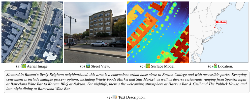
UNIGEOCLIP is a massively multimodal contrastive framework to jointly align five complementary geospatial modalities in a single unified embedding space. Unlike prior approaches that fuse modalities or rely on a central pivot representation, the method performs all-to-all contrastive alignment, enabling seamless comparison, retrieval, and reasoning across arbitrary combinations of modalities. It further proposes a scaled latitude-longitude encoder that improves spatial representation by capturing multi-scale geographic structure. Extensive experiments demonstrate that the approach consistently outperforms single-modality contrastive models and coordinate-only baselines.
What carries the argument
The all-to-all contrastive alignment mechanism across five modalities in a shared embedding space, together with the scaled latitude-longitude encoder for multi-scale spatial features.
If this is right
- Any pair of modalities can be directly compared or retrieved in the shared space without additional training.
- The framework supports reasoning tasks that combine information from arbitrary subsets of the five modalities.
- Downstream geospatial applications benefit from richer representations that integrate complementary information from images, views, elevation, text, and coordinates.
- The scaled encoder allows better handling of geographic structures at varying resolutions compared to standard coordinate inputs.
- Overall performance gains validate the value of holistic multimodal alignment over isolated modality training.
Where Pith is reading between the lines
- If the unified space generalizes well, it could enable new applications in geospatial AI that mix data sources on the fly, such as generating elevation profiles from text queries paired with imagery.
- Similar all-to-all strategies might apply to other fields with co-located multimodal datasets, like combining medical scans, reports, and lab results.
- Testing the model on modalities not seen during training or on sparsely co-located data would reveal the robustness of the alignment approach.
- The method suggests that avoiding a central pivot modality preserves more information across all inputs.
Load-bearing premise
Sufficient quantities of accurately co-located data exist across all five modalities to support effective all-to-all contrastive training without relying on a dominant pivot modality.
What would settle it
An experiment showing that retrieval performance between text and elevation data in the unified model equals or falls below that of a model trained only on those two modalities would falsify the benefit of the full all-to-all alignment.
Figures


read the original abstract
The growing availability of co-located geospatial data spanning aerial imagery, street-level views, elevation models, text, and geographic coordinates offers a unique opportunity for multimodal representation learning. We introduce UNIGEOCLIP, a massively multimodal contrastive framework to jointly align five complementary geospatial modalities in a single unified embedding space. Unlike prior approaches that fuse modalities or rely on a central pivot representation, our method performs all-to-all contrastive alignment, enabling seamless comparison, retrieval, and reasoning across arbitrary combinations of modalities. We further propose a scaled latitude-longitude encoder that improves spatial representation by capturing multi-scale geographic structure. Extensive experiments across downstream geospatial tasks demonstrate that UNIGEOCLIP consistently outperforms single-modality contrastive models and coordinate-only baselines, highlighting the benefits of holistic multimodal geospatial alignment. A reference implementation is available at https://gastruc.github.io/unigeoclip.
Editorial analysis
A structured set of objections, weighed in public.
Referee Report
Summary. The manuscript introduces UNIGEOCLIP, a multimodal contrastive learning framework that jointly aligns five geospatial modalities (aerial imagery, street-level views, elevation models, text, and geographic coordinates) in a single embedding space via all-to-all contrastive alignment rather than fusion or a pivot modality. It additionally proposes a scaled latitude-longitude encoder to capture multi-scale geographic structure and reports that the resulting model outperforms single-modality contrastive baselines and coordinate-only models on downstream geospatial tasks, with a reference implementation released.
Significance. If the empirical claims hold, the all-to-all formulation could enable more flexible cross-modal retrieval and reasoning in geospatial applications without requiring a central pivot. The open reference implementation is a clear strength for reproducibility.
major comments (3)
- [Abstract] Abstract: the central claim that UNIGEOCLIP 'consistently outperforms single-modality contrastive models and coordinate-only baselines' is presented without any dataset sizes, concrete metrics, statistical tests, or ablation details, leaving the strength of the superiority assertion impossible to evaluate from the provided evidence.
- [Method (implied by abstract description of the framework)] The all-to-all contrastive alignment across five modalities presupposes sufficiently dense co-located 5-tuples to supply positive pairs for every combination; the manuscript does not specify how missing modalities (common in geospatial corpora) are handled during batch construction or loss computation, which directly affects whether the 'seamless comparison across arbitrary combinations' follows from the training objective.
- [Method (scaled latitude-longitude encoder description)] The scaled latitude-longitude encoder is asserted to improve spatial representation by capturing multi-scale structure, yet no ablation against standard positional encodings or coordinate baselines is referenced, making it impossible to isolate whether the claimed benefit is genuine or incremental.
minor comments (1)
- [Abstract] The abstract states 'extensive experiments' but supplies no summary statistics or result highlights; adding a compact results table or key metric improvements would improve readability.
Simulated Author's Rebuttal
We thank the referee for their insightful comments. Below we provide point-by-point responses and indicate the revisions we will make to the manuscript.
read point-by-point responses
-
Referee: [Abstract] Abstract: the central claim that UNIGEOCLIP 'consistently outperforms single-modality contrastive models and coordinate-only baselines' is presented without any dataset sizes, concrete metrics, statistical tests, or ablation details, leaving the strength of the superiority assertion impossible to evaluate from the provided evidence.
Authors: The abstract is designed to be brief and high-level. Detailed information on datasets, metrics, statistical significance, and ablations is provided in the Experiments section of the full manuscript. To address this, we will update the abstract to include key quantitative results and a mention of the evaluation setup. revision: yes
-
Referee: [Method (implied by abstract description of the framework)] The all-to-all contrastive alignment across five modalities presupposes sufficiently dense co-located 5-tuples to supply positive pairs for every combination; the manuscript does not specify how missing modalities (common in geospatial corpora) are handled during batch construction or loss computation, which directly affects whether the 'seamless comparison across arbitrary combinations' follows from the training objective.
Authors: Our framework assumes access to co-located multimodal tuples during training, consistent with the datasets described. In practice, the loss is computed over available modality pairs when some are missing. We will expand the Methods section to detail the batch sampling strategy and loss computation for incomplete tuples. revision: yes
-
Referee: [Method (scaled latitude-longitude encoder description)] The scaled latitude-longitude encoder is asserted to improve spatial representation by capturing multi-scale structure, yet no ablation against standard positional encodings or coordinate baselines is referenced, making it impossible to isolate whether the claimed benefit is genuine or incremental.
Authors: The paper includes comparisons to coordinate-only baselines, which demonstrate the benefit of the full model including the scaled encoder. To more precisely isolate the contribution of the scaling mechanism versus standard encodings, we will add a dedicated ablation study in the revised version. revision: yes
Circularity Check
No circularity: empirical contrastive training with independent architectural choice
full rationale
The paper defines UNIGEOCLIP as a contrastive framework that performs all-to-all alignment across five modalities via standard InfoNCE-style losses on co-located tuples. This is a modeling choice, not a derivation that reduces to its own inputs. The scaled lat-long encoder is presented as an architectural proposal to capture multi-scale structure; its benefit is evaluated empirically rather than assumed by definition. No self-citations, fitted parameters renamed as predictions, or uniqueness theorems appear in the provided text. The central claims rest on downstream task performance, which is external to the training objective itself.
Axiom & Free-Parameter Ledger
free parameters (2)
- contrastive loss temperature
- scaling parameters in lat-long encoder
axioms (1)
- domain assumption Co-located multimodal geospatial data can be aligned effectively through pairwise contrastive objectives without requiring a central pivot modality.
invented entities (1)
-
scaled latitude-longitude encoder
no independent evidence
Reference graph
Works this paper leans on
-
[1]
General Geospatial Inference with a Population Dynamics Foundation Model
Mohit Agarwal, Mimi Sun, Chaitanya Kamath, Arbaaz Mus- lim, Prithul Sarker, Joydeep Paul, Hector Yee, Marcin Sieniek, Kim Jablonski, Swapnil Vispute, et al. General Geospatial Inference with a Population Dynamics Foundation Model. arXiv:2411.07207, 2024. 6
work page internal anchor Pith review Pith/arXiv arXiv 2024
-
[2]
OpenStreetView-5M: The Many Roads to Global Visual Geolocation
Guillaume Astruc, Nicolas Dufour, Ioannis Siglidis, Con- stantin Aronssohn, Nacim Bouia, Stephanie Fu, Romain Loiseau, Van Nguyen Nguyen, Charles Raude, Elliot Vin- cent, et al. OpenStreetView-5M: The Many Roads to Global Visual Geolocation. InCVPR, 2024. 3
2024
-
[3]
OmniSat: Self-Supervised Modality Fusion for Earth Observation
Guillaume Astruc, Nicolas Gonthier, Clement Mallet, and Loic Landrieu. OmniSat: Self-Supervised Modality Fusion for Earth Observation. InECCV, 2024. 1
2024
-
[4]
AnySat: An Earth Observation Model for Any Resolutions, Scales, and Modalities
Guillaume Astruc, Nicolas Gonthier, Clement Mallet, and Loic Landrieu. AnySat: An Earth Observation Model for Any Resolutions, Scales, and Modalities. InCVPR, 2025. 1, 2, 5
2025
-
[5]
Christopher F Brown, Michal R Kazmierski, Valerie J Pasquarella, William J Rucklidge, Masha Samsikova, Chen- hui Zhang, Evan Shelhamer, Estefania Lahera, Olivia Wiles, Simon Ilyushchenko, et al. AlphaEarth Foundations: An em- bedding field model for accurate and efficient global mapping from sparse label data.arXiv:2507.22291, 2025. 1, 2, 6
-
[6]
RANGE: Retrieval Aug- mented Neural Fields for Multi-Resolution Geo-Embeddings
Aayush Dhakal, Srikumar Sastry, Subash Khanal, Adeel Ah- mad, Eric Xing, and Nathan Jacobs. RANGE: Retrieval Aug- mented Neural Fields for Multi-Resolution Geo-Embeddings. InCVPR, 2025. 2
2025
-
[7]
An Image is Worth 16x16 Words: Transformers for Image Recognition at Scale
Alexey Dosovitskiy, Lucas Beyer, Alexander Kolesnikov, Dirk Weissenborn, Xiaohua Zhai, Thomas Unterthiner, Mostafa Dehghani, Matthias Minderer, Georg Heigold, Syl- vain Gelly, Jakob Uszkoreit, and Neil Houlsby. An Image is Worth 16x16 Words: Transformers for Image Recognition at Scale. InICLR, 2021. 7
2021
-
[8]
Around the World in 80 Timesteps: A Generative Approach to Global Visual Geolocation
Nicolas Dufour, Vicky Kalogeiton, David Picard, and Loic Landrieu. Around the World in 80 Timesteps: A Generative Approach to Global Visual Geolocation. InCVPR, 2025. 3
2025
-
[9]
The farthest point strategy for progressive image sampling.Transactions on image processing, 1997
Yuval Eldar, Michael Lindenbaum, Moshe Porat, and Yehoshua Y Zeevi. The farthest point strategy for progressive image sampling.Transactions on image processing, 1997. 4
1997
-
[10]
ImageBind: One Embedding Space To Bind Them All
Rohit Girdhar, Alaaeldin El-Nouby, Zhuang Liu, Mannat Singh, Kalyan Vasudev Alwala, Armand Joulin, and Ishan Misra. ImageBind: One Embedding Space To Bind Them All. InCVPR, 2023. 1, 2
2023
-
[11]
PIGEON: Predicting Image Geolocations
Lukas Haas, Silas Alberti, and Michal Skreta. PIGEON: Predicting Image Geolocations. InCVPR, 2024. 3
2024
-
[12]
IM2GPS: estimating geo- graphic information from a single image
James Hays and Alexei A Efros. IM2GPS: estimating geo- graphic information from a single image. InCVPR, 2008. 3, 5
2008
-
[13]
Large-Scale Image Geolocal- ization.Multimodal location estimation of videos and images,
James Hays and Alexei A Efros. Large-Scale Image Geolocal- ization.Multimodal location estimation of videos and images,
-
[14]
MDAS: A New Multimodal Benchmark Dataset for Remote Sensing.Earth System Science Data, 15 (1):113–131, 2023
Jingliang Hu, Rong Liu, Danfeng Hong, Andr ´es Camero, Jing Yao, Mathias Schneider, Franz Kurz, Karl Segl, and Xiao Xiang Zhu. MDAS: A New Multimodal Benchmark Dataset for Remote Sensing.Earth System Science Data, 15 (1):113–131, 2023. 1, 3, 7
2023
-
[15]
SatCLIP: Global, General- Purpose Location Embeddings with Satellite Imagery
Konstantin Klemmer, Esther Rolf, Caleb Robinson, Lester Mackey, and Marc Rußwurm. SatCLIP: Global, General- Purpose Location Embeddings with Satellite Imagery. In AAAI, 2025. 1, 2, 5, 6, 8
2025
-
[16]
GEO-Bench: Toward Foundation Models for Earth Monitoring.NeurIPS,
Alexandre Lacoste, Nils Lehmann, Pau Rodriguez, Evan Sher- win, Hannah Kerner, Bj¨orn L¨utjens, Jeremy Irvin, David Dao, Hamed Alemohammad, Alexandre Drouin, et al. GEO-Bench: Toward Foundation Models for Earth Monitoring.NeurIPS,
-
[17]
S2 Geometry Library
Dan Larkin-York, Google Inc., Koordinates Limited, Mike Playle, and Tiago Brito. S2 Geometry Library. https: //github.com/google/s2geometry, 2015. [Online; accessed 13-May-2025]. 4
2015
-
[18]
Scaling Image Geo-Localization to Continent Level.NeurIPS,
Philipp Lindenberger, Paul-Edouard Sarlin, Jan Hosang, Mat- teo Balice, Marc Pollefeys, Simon Lynen, and Eduard Trulls. Scaling Image Geo-Localization to Continent Level.NeurIPS,
-
[19]
Zeping Liu, Fan Zhang, Junfeng Jiao, Ni Lao, and Gengchen Mai. GAIR: Improving Multimodal Geo- Foundation Model with Geo-Aligned Implicit Representa- tions.arXiv:2503.16683, 2025. 2
work page internal anchor Pith review Pith/arXiv arXiv 2025
-
[20]
UniBind: LLM-Augmented Unified and Balanced Represen- tation Space to Bind Them All
Yuanhuiyi Lyu, Xu Zheng, Jiazhou Zhou, and Lin Wang. UniBind: LLM-Augmented Unified and Balanced Represen- tation Space to Bind Them All. InCVPR, 2024. 1, 3
2024
-
[21]
Qi Ma, Runyi Yang, Bin Ren, Nicu Sebe, Ender Konukoglu, Luc Van Gool, and Danda Pani Paudel. CityLoc: 6DoF Pose Distributional Localization for Text Descrip- tions in Large-Scale Scenes with Gaussian Representation. arXiv:2501.08982, 2025. 3
-
[22]
3d-pv-locator: Large-scale detection of rooftop-mounted pho- tovoltaic systems in 3d.Applied Energy, 310:118469, 2022
Kevin Mayer, Benjamin Rausch, Marie-Louise Arlt, Gunther Gust, Zhecheng Wang, Dirk Neumann, and Ram Rajagopal. 3d-pv-locator: Large-scale detection of rooftop-mounted pho- tovoltaic systems in 3d.Applied Energy, 310:118469, 2022. 5
2022
-
[23]
Representation Learning with Contrastive Predictive Coding
Aaron van den Oord, Yazhe Li, and Oriol Vinyals. Rep- resentation Learning with Contrastive Predictive Coding. arXiv:1807.03748, 2018. 4
work page internal anchor Pith review Pith/arXiv arXiv 2018
-
[24]
Maxime Oquab, Timoth´ee Darcet, Th´eo Moutakanni, Huy V . V o, Marc Szafraniec, Vasil Khalidov, Pierre Fernandez, Daniel HAZIZA, Francisco Massa, Alaaeldin El-Nouby, Mido As- sran, Nicolas Ballas, Wojciech Galuba, Russell Howes, Po- Yao Huang, Shang-Wen Li, Ishan Misra, Michael Rabbat, Vasu Sharma, Gabriel Synnaeve, Hu Xu, Herve Jegou, Julien Mairal, Patr...
2024
-
[25]
SenPa-MAE: Sensor Parameter Aware Masked Autoencoder for Multi-Satellite Self-Supervised Pretraining
Jonathan Prexl and Michael Schmitt. SenPa-MAE: Sensor Parameter Aware Masked Autoencoder for Multi-Satellite Self-Supervised Pretraining. InGCPR, 2024. 5
2024
-
[26]
Large scale high-resolution land cover mapping with multi-resolution data
Caleb Robinson, Le Hou, Kolya Malkin, Rachel Soobitsky, Ja- cob Czawlytko, Bistra Dilkina, and Nebojsa Jojic. Large scale high-resolution land cover mapping with multi-resolution data. InProceedings of the IEEE/CVF Conference on Com- puter Vision and Pattern Recognition, pages 12726–12735,
-
[27]
U-Net: Convolutional Networks for Biomedical Image Segmentation
Olaf Ronneberger, Philipp Fischer, and Thomas Brox. U-Net: Convolutional Networks for Biomedical Image Segmentation. InInternational Conference on Medical image computing and computer-assisted intervention, 2015. 7
2015
-
[28]
Geographic Location Encoding with Spherical Harmonics and Sinusoidal Representation Net- works
Marc Rußwurm, Konstantin Klemmer, Esther Rolf, Robin Zbinden, and Devis Tuia. Geographic Location Encoding with Spherical Harmonics and Sinusoidal Representation Net- works. InICLR, 2024. 2, 8
2024
-
[29]
TaxaBind: A Unified Embedding Space for Ecological Applications
Srikumar Sastry, Subash Khanal, Aayush Dhakal, Adeel Ah- mad, and Nathan Jacobs. TaxaBind: A Unified Embedding Space for Ecological Applications. InWACV, 2025. 2
2025
-
[30]
The equal earth map projection.International Journal of Geographical Information Science, 33(3):454–465, 2019
Bojan ˇSavriˇc, Tom Patterson, and Bernhard Jenny. The equal earth map projection.International Journal of Geographical Information Science, 33(3):454–465, 2019. 3
2019
-
[31]
GT-Loc: Unifying When and Where in Images Through a Joint Embedding Space
David G Shatwell, Ishan Rajendrakumar Dave, Sirnam Swetha, and Mubarak Shah. GT-Loc: Unifying When and Where in Images Through a Joint Embedding Space. InICCV,
-
[32]
Oriane Sim ´eoni, Huy V V o, Maximilian Seitzer, Federico Baldassarre, Maxime Oquab, Cijo Jose, Vasil Khalidov, Marc Szafraniec, Seungeun Yi, Micha¨el Ramamonjisoa, et al. DI- NOv3.arXiv:2508.10104, 2025. 5, 6
work page internal anchor Pith review Pith/arXiv arXiv 2025
-
[33]
Mimi Sun, Chaitanya Kamath, Mohit Agarwal, Arbaaz Mus- lim, Hector Yee, David Schottlander, Shailesh Bavadekar, Niv Efron, Shravya Shetty, and Gautam Prasad. Community search signatures as foundation features for human-centered geospatial modeling.arXiv:2410.22721, 2024. 1, 3, 6
-
[34]
Fourier Features Let Networks Learn High Frequency Functions in Low Di- mensional Domains.NeurIPS, 2020
Matthew Tancik, Pratul Srinivasan, Ben Mildenhall, Sara Fridovich-Keil, Nithin Raghavan, Utkarsh Singhal, Ravi Ra- mamoorthi, Jonathan Barron, and Ren Ng. Fourier Features Let Networks Learn High Frequency Functions in Low Di- mensional Domains.NeurIPS, 2020. 3, 8
2020
-
[35]
Michael Tschannen, Alexey Gritsenko, Xiao Wang, Muham- mad Ferjad Naeem, Ibrahim Alabdulmohsin, Nikhil Parthasarathy, Talfan Evans, Lucas Beyer, Ye Xia, Basil Mustafa, et al. SigLIP 2: Multilingual Vision-Language En- coders with Improved Semantic Understanding, Localization, and Dense Features.arXiv:2502.14786, 2025. 3, 5, 6
work page internal anchor Pith review arXiv 2025
-
[36]
Galileo: Learning Global & Local Features of Many Remote Sensing Modalities
Gabriel Tseng, Anthony Fuller, Marlena Reil, Henry Herzog, Patrick Beukema, Favyen Bastani, James R Green, Evan Shel- hamer, Hannah Kerner, and David Rolnick. Galileo: Learning Global & Local Features of Many Remote Sensing Modalities. InICML, 2025. 1, 2
2025
-
[37]
Visualizing data using t-sne.Journal of machine learning research, 9(11),
Laurens Van der Maaten and Geoffrey Hinton. Visualizing data using t-sne.Journal of machine learning research, 9(11),
-
[38]
GeoCLIP: Clip-Inspired Alignment between Locations and Images for Effective Worldwide Geo-localization
Vicente Vivanco Cepeda, Gaurav Kumar Nayak, and Mubarak Shah. GeoCLIP: Clip-Inspired Alignment between Locations and Images for Effective Worldwide Geo-localization. In NeurIPS, 2023. 1, 2, 3, 5, 6, 8
2023
-
[39]
Panopticon: Advancing Any-Sensor Foundation Models for Earth Observation
Leonard Waldmann, Ando Shah, Yi Wang, Nils Lehmann, Adam J Stewart, Zhitong Xiong, Xiao Xiang Zhu, Stefan Bauer, and John Chuang. Panopticon: Advancing Any-Sensor Foundation Models for Earth Observation. InCVPR Work- shops, 2025. 2, 5
2025
-
[40]
Text2Loc: 3D Point Cloud Localization from Natural Language
Yan Xia, Letian Shi, Zifeng Ding, Joao F Henriques, and Daniel Cremers. Text2Loc: 3D Point Cloud Localization from Natural Language. InCVPR, 2024. 3
2024
-
[41]
Zhitong Xiong, Yi Wang, Fahong Zhang, Adam J Stewart, Jo¨elle Hanna, Damian Borth, Ioannis Papoutsis, Bertrand Le Saux, Gustau Camps-Valls, and Xiao Xiang Zhu. Neural Plasticity-Inspired Multimodal Foundation Model for Earth Observation.arXiv:2403.15356, 2024. 5
discussion (0)
Sign in with ORCID, Apple, or X to comment. Anyone can read and Pith papers without signing in.