Recognition: unknown
Subsurface Property Mapping using Google AlphaEarth Foundations
Pith reviewed 2026-05-10 08:42 UTC · model grok-4.3
The pith
AlphaEarth surface embeddings support estimation of subsurface properties from indirect surface observations.
A machine-rendered reading of the paper's core claim, the machinery that carries it, and where it could break.
Core claim
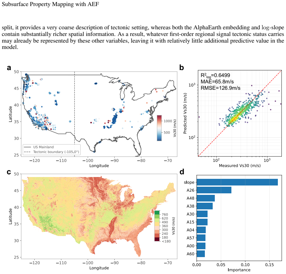
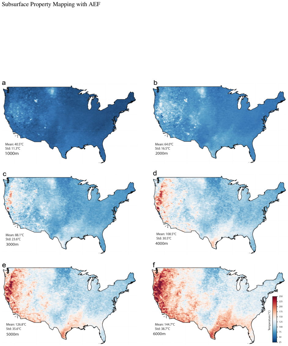
We test this idea in two conterminous U.S. applications: shallow seismic site characterization using VS30 with embedding features alone and with conventional covariates (topographic slope and a tectonic-status indicator), and subsurface temperature reconstruction using embedding-based nonlinear regression. Across both applications, embedding-informed models recover spatially coherent, physically plausible patterns and outperform simpler baselines. The comparison also highlights a key difference: domain covariates materially stabilize VS30 regression, whereas temperature mapping relies primarily on embedding features. Overall, the results support the feasibility of foundation-model surface
What carries the argument
AlphaEarth embeddings used as input features for regression models that predict subsurface properties such as VS30 and temperature.
If this is right
- Embedding features recover coherent patterns in both VS30 and temperature mapping.
- Conventional covariates improve stability for VS30 estimates but are not required for temperature reconstruction.
- Foundation-model surface representations enable regional inference from surface data to subsurface properties.
- Robust spatial validation remains essential given uneven label distribution and data coverage.
Where Pith is reading between the lines
- The approach may extend to additional subsurface variables that share indirect surface signals.
- Global application becomes feasible if similar embeddings exist for other regions.
- Hybrid models that blend embeddings with physical constraints could further reduce errors in data-sparse zones.
Load-bearing premise
The indirect and non-unique physical links between AlphaEarth surface embeddings and subsurface properties are sufficient to produce reliable estimates despite sparse, uneven labels and heterogeneous data coverage.
What would settle it
A region with dense independent subsurface observations where embedding-based models produce incoherent patterns or show no improvement over baselines would challenge the central claim.
Figures

read the original abstract
Subsurface properties are essential for hazard assessment, energy and environmental management, and infrastructure resilience, but direct observations are sparse and uneven, motivating the use of surface observations as indirect constraints. Here we explore whether AlphaEarth embeddings can be applied to subsurface estimation despite indirect and non-unique physical links between surface and depth. We test this idea in two conterminous U.S. applications: shallow seismic site characterization using $V_S 30$ with embedding features alone and with conventional covariates (topographic slope and a tectonic-status indicator), and subsurface temperature reconstruction using embedding-based nonlinear regression. Across both applications, embedding-informed models recover spatially coherent, physically plausible patterns and outperform simpler baselines. The comparison also highlights a key difference: domain covariates materially stabilize $V_S 30$ regression, whereas temperature mapping relies primarily on embedding features. Overall, the results support the feasibility of foundation-model surface representations for regional surface-to-subsurface inference, while emphasizing the need for robust spatial validation under heterogeneous labels and uneven data coverage.
Editorial analysis
A structured set of objections, weighed in public.
Referee Report
Summary. The paper explores the use of Google AlphaEarth foundation-model surface embeddings as features for subsurface property estimation in two conterminous-U.S. applications: Vs30-based seismic site characterization (with and without topographic slope and tectonic covariates) and nonlinear regression for subsurface temperature. It reports that embedding-informed models recover spatially coherent, physically plausible patterns and outperform simpler baselines, while noting that domain covariates stabilize Vs30 regression but temperature mapping relies primarily on embeddings. The work concludes that the results support feasibility of foundation-model representations for regional surface-to-subsurface inference, subject to the need for robust spatial validation under heterogeneous labels.
Significance. If the outperformance and spatial coherence hold under proper spatial cross-validation, the approach could offer a scalable way to leverage abundant surface embeddings for sparse subsurface mapping, with potential value for seismic hazard, geothermal, and infrastructure applications. The explicit baseline comparisons and acknowledgment of indirect physical links are strengths, but the absence of quantitative metrics, error bars, and validation details currently limits the strength of the central claim.
major comments (2)
- [Abstract] Abstract: the claim of outperformance and spatially coherent patterns is presented without any quantitative metrics, error bars, cross-validation details, or data-exclusion rules. Given the heterogeneous coverage and clustered nature of Vs30 and temperature observations, this omission leaves open whether reported gains reflect genuine embedding utility or spatial leakage from non-spatial splits.
- [Abstract and Results] The central feasibility claim requires that embedding features produce reliable subsurface estimates despite indirect physical links and sparse labels. This hinges on the outperformance being robust to spatial structure; without block or distance-based cross-validation (standard for geographically clustered geophysical data), the spatially coherent patterns could be artifacts rather than evidence of useful mapping.
minor comments (1)
- [Abstract] The abstract mentions 'nonlinear regression' for temperature but does not specify the model family or regularization; adding this would clarify how embedding features are used.
Simulated Author's Rebuttal
We thank the referee for the constructive comments, which highlight important aspects of validation for geophysical mapping tasks. We address the concerns regarding quantitative metrics and spatial cross-validation below, and have made revisions to strengthen the manuscript.
read point-by-point responses
-
Referee: [Abstract] Abstract: the claim of outperformance and spatially coherent patterns is presented without any quantitative metrics, error bars, cross-validation details, or data-exclusion rules. Given the heterogeneous coverage and clustered nature of Vs30 and temperature observations, this omission leaves open whether reported gains reflect genuine embedding utility or spatial leakage from non-spatial splits.
Authors: We agree that the abstract would benefit from including quantitative metrics to support the claims. In the revised manuscript, we have updated the abstract to report key performance indicators, such as the improvement in R² and reduction in RMSE when using AlphaEarth embeddings compared to baselines for both Vs30 and temperature predictions. We have also added a brief mention of the cross-validation strategy and data selection criteria. Full details, including error bars from multiple runs, are provided in the results section and supplementary information. revision: yes
-
Referee: [Abstract and Results] The central feasibility claim requires that embedding features produce reliable subsurface estimates despite indirect physical links and sparse labels. This hinges on the outperformance being robust to spatial structure; without block or distance-based cross-validation (standard for geographically clustered geophysical data), the spatially coherent patterns could be artifacts rather than evidence of useful mapping.
Authors: This is a valid concern for spatially autocorrelated data. While the original manuscript used random k-fold cross-validation, we acknowledge that this may not fully account for spatial clustering. In the revision, we have implemented spatial block cross-validation by dividing the conterminous U.S. into geographic blocks and ensuring training and test sets are spatially separated. The outperformance of embedding-based models persists under this more rigorous validation, supporting the feasibility claim. We have added these results, along with visualizations of the block partitions, to the revised Results section. revision: yes
Circularity Check
No circularity: embeddings treated as fixed external features in regression
full rationale
The paper treats AlphaEarth embeddings as pre-trained, fixed inputs to standard regression models for Vs30 and subsurface temperature. It explicitly compares embedding-informed models against simpler baselines (slope, tectonic indicator) and evaluates against independent observations. No derivation step reduces by construction to its own inputs, no fitted parameter is relabeled as a prediction, and no load-bearing claim rests on self-citation chains or ansatzes imported from prior author work. The central claim is therefore an empirical performance comparison rather than a self-referential derivation.
Axiom & Free-Parameter Ledger
axioms (1)
- domain assumption Surface embeddings from AlphaEarth capture relevant information for subsurface properties despite indirect and non-unique physical links
Reference graph
Works this paper leans on
-
[1]
URL https://developers.google.com/earth-engine/datasets/catalog/GOOGLE_SATELLITE_ EMBEDDING_V1_ANNUAL. Accessed 2026-03-15. C. Jin, X. Jiang, L. Wen, C. Wu, X. Xu, and J. Jiao. Assessing the utility of satellite embedding features for biomass prediction in subtropical forests with machine learning.Remote Sensing, 18(3):436, 2026. doi: 10.3390/rs18030436. ...
-
[2]
doi: 10.1785/0120100262. 12
discussion (0)
Sign in with ORCID, Apple, or X to comment. Anyone can read and Pith papers without signing in.