Recognition: unknown
Evolving Thematic Map Design in Academic Cartography: A Thirty-Year Study Based on Multilingual Journals
Pith reviewed 2026-05-08 12:33 UTC · model grok-4.3
The pith
Academic maps in Chinese and English journals have converged on similar restrained designs and parallel trends over thirty years.
A machine-rendered reading of the paper's core claim, the machinery that carries it, and where it could break.
Core claim
Chinese- and English-language academic maps share highly similar structural conventions, typically employing restrained color palettes with neutral dominant hues, low saturation, high brightness, and limited hue diversity, as well as centered layouts with high main-map occupation ratios. Differences exist in that English-language maps show slightly greater hue richness and compactness, whereas Chinese-language maps historically rely more on neutral hues and integrated layouts. Temporal analysis reveals parallel evolutionary trends in both groups, including increasing element richness, legend usage, and hue diversity, alongside stable layout structures, indicating that academic map design is,
What carries the argument
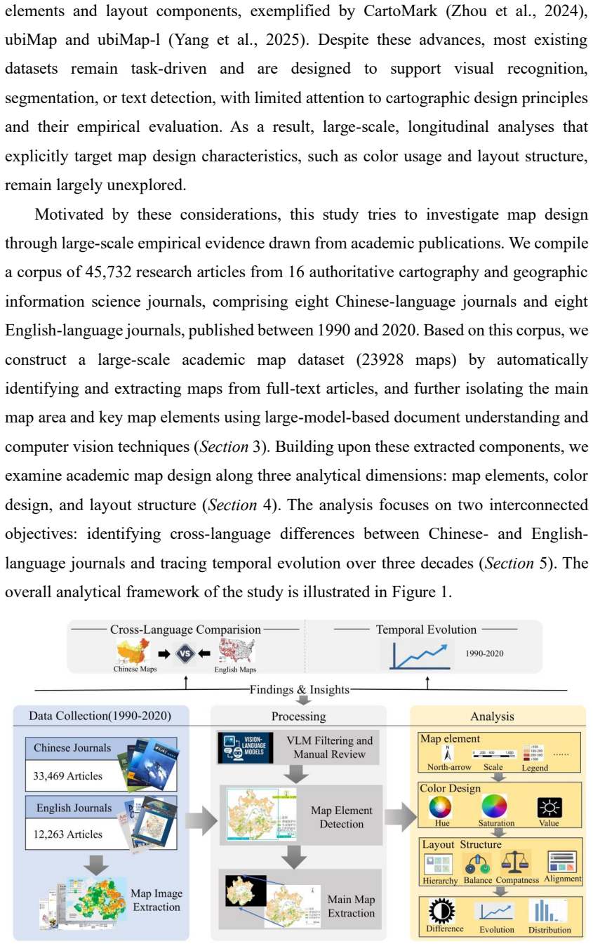
Automated extraction of 23,928 maps from 45,732 articles via computer vision and large-model document parsing, followed by quantification of design across the three dimensions of elements, color, and layout.
If this is right
- Both language communities show rising use of legends and map elements alongside greater hue diversity while preserving centered, high-occupation layouts.
- Minor persistent differences remain, with English maps slightly more compact and hue-rich and Chinese maps historically favoring neutral tones and integrated arrangements.
- The overall pattern favors institutional and professional convergence over cultural divergence in how academic cartographers present thematic information.
- Layout stability across decades suggests that core spatial framing conventions in academic publishing have changed little despite technological shifts in map production.
Where Pith is reading between the lines
- The observed convergence may stem from shared use of international GIS software and journal style guides that cross language boundaries.
- Cartography teaching materials could be updated to emphasize these documented temporal trends rather than assuming fixed language-based styles.
- The same computer-vision pipeline could be reused to monitor design changes in figures from other scientific domains such as diagrams in physics or biology papers.
- If convergence continues, future map-making tools might default to the observed restrained palettes and centered layouts as de-facto standards.
Load-bearing premise
The automated extraction and quantification of map design features via computer vision and large models accurately reflects the intended design practices without significant misclassification, bias, or loss of context.
What would settle it
A hand-coded audit of several hundred randomly selected maps from the dataset by cartography experts, checking whether the automated counts of elements, color statistics, and layout metrics match human judgments; substantial mismatch would falsify the reliability of the trends.
Figures
read the original abstract
Thematic maps play a central role in academic communication, yet their large-scale design evolution has rarely been examined empirically. This study presents a longitudinal and multilingual analysis of thematic map design practices in academic cartography from 1990 to 2020. We compile a corpus of 45,732 research articles from sixteen authoritative Chinese- and English-language journals and extract 23,928 maps using computer vision and large-model-based document parsing to build a structured dataset. Map design characteristics are quantified across three dimensions: map elements, color design, and layout structure. Results show that Chinese- and Englishlanguage academic maps share highly similar structural conventions, typically employing restrained color palettes with neutral dominant hues, low saturation, high brightness, and limited hue diversity, as well as centered layouts with high main-map occupation ratios. Differences exist in that English-language maps show slightly greater hue richness and compactness, whereas Chinese-language maps historically rely more on neutral hues and integrated layouts. Temporal analysis reveals parallel evolutionary trends in both groups, including increasing element richness, legend usage, and hue diversity, alongside stable layout structures. Overall, the findings suggest that academic map design evolution is characterized more by institutional convergence than cultural divergence.
Editorial analysis
A structured set of objections, weighed in public.
Referee Report
Summary. The paper presents a longitudinal, multilingual analysis of thematic map design in academic cartography (1990–2020) based on 45,732 articles from 16 Chinese- and English-language journals. Using computer vision and large-model document parsing, it extracts 23,928 maps and quantifies design features across map elements, color (hue/saturation/brightness, diversity), and layout (centeredness, main-map occupation, compactness). The central claim is that design evolution is characterized by institutional convergence rather than cultural divergence, evidenced by shared restrained palettes, neutral hues, high brightness, centered layouts, and parallel temporal trends (increasing element richness, legend use, hue diversity) with only minor differences between language groups.
Significance. If the automated extraction and quantification pipeline proves reliable, the work offers a rare large-scale empirical dataset on cartographic practices over three decades, documenting convergence in restrained color use and layout conventions alongside gradual increases in element complexity. This could inform both cartography education and cross-cultural publishing standards by shifting emphasis from assumed cultural divergence to shared institutional norms.
major comments (2)
- [Methods] Methods section on map extraction and feature quantification: No validation metrics (precision/recall for map detection, inter-annotator agreement for element classification, error rates for color histogram or layout parsing), manual audit, or bias analysis of the 23,928 extracted maps are reported. Systematic errors—such as lower detection rates for complex Chinese layouts, misclassification of non-map graphics, or inaccurate color metrics on scanned figures—could artifactually inflate the observed parallels between language groups and thereby undermine the central convergence claim.
- [Results] Results and temporal analysis sections: The reported trends (e.g., increasing hue diversity, stable layout structures) and the conclusion that institutional convergence dominates cultural divergence rest entirely on the unvalidated automated features; without fidelity checks, it is impossible to determine whether the quantified similarities reflect actual design practices or pipeline artifacts.
minor comments (2)
- [Abstract] Abstract: The sixteen journals are referenced but not named; listing them (or providing a supplementary table) would improve reproducibility and allow readers to assess journal-specific biases.
- [Methods] Figure captions and methods: The exact computer-vision models, large-model prompts, and color-space conversion details are not fully specified, making independent replication difficult.
Simulated Author's Rebuttal
We thank the referee for the constructive and detailed comments, which highlight an important aspect of our methodology. We address the concerns about validation of the automated pipeline below and will revise the manuscript accordingly to provide greater transparency and support for our claims of institutional convergence.
read point-by-point responses
-
Referee: [Methods] Methods section on map extraction and feature quantification: No validation metrics (precision/recall for map detection, inter-annotator agreement for element classification, error rates for color histogram or layout parsing), manual audit, or bias analysis of the 23,928 extracted maps are reported. Systematic errors—such as lower detection rates for complex Chinese layouts, misclassification of non-map graphics, or inaccurate color metrics on scanned figures—could artifactually inflate the observed parallels between language groups and thereby undermine the central convergence claim.
Authors: We agree that explicit validation metrics and bias analysis were not reported in the original Methods section, which is a limitation that could affect confidence in the quantified similarities. In the revised manuscript, we will add a dedicated validation subsection describing: (1) a manual audit of a stratified random sample of 1,000 extracted maps (500 per language group) with precision/recall for detection and element classification; (2) inter-annotator agreement (Cohen's kappa) on a subset of 300 maps for layout and color features; and (3) error-rate analysis for color histograms and layout parsing, including checks for scanned figures and potential Chinese-layout biases. These additions will directly test whether systematic errors could artifactually support the convergence findings. revision: yes
-
Referee: [Results] Results and temporal analysis sections: The reported trends (e.g., increasing hue diversity, stable layout structures) and the conclusion that institutional convergence dominates cultural divergence rest entirely on the unvalidated automated features; without fidelity checks, it is impossible to determine whether the quantified similarities reflect actual design practices or pipeline artifacts.
Authors: The temporal trends and convergence conclusion do depend on the automated features. Adding the validation metrics, manual audit results, and bias analysis to the Methods section will allow us to demonstrate in the revised Results that the pipeline's accuracy is high enough to support the observed parallel trends (e.g., increasing element richness and hue diversity) and the dominance of institutional over cultural factors. We will also include a short robustness discussion in Results showing that the main findings hold after accounting for potential error rates. revision: yes
Circularity Check
No circularity: purely observational data analysis with no derivations or self-referential reductions
full rationale
The paper compiles a corpus of 45,732 articles, extracts 23,928 maps via computer vision and large-model parsing, then quantifies features in elements, color, and layout to compare Chinese- and English-language maps over time. The central claim of institutional convergence over cultural divergence follows directly from these empirical comparisons and temporal trends, without any equations, fitted parameters renamed as predictions, self-citations as load-bearing premises, or ansatzes smuggled in. No load-bearing step reduces by construction to prior inputs; the work is self-contained as standard corpus-based observation.
Axiom & Free-Parameter Ledger
axioms (1)
- domain assumption The sixteen authoritative Chinese- and English-language journals adequately represent broader academic cartography practices from 1990 to 2020.
Reference graph
Works this paper leans on
-
[1]
Given the scope of this work, we selectively review representative studies and focus on (1) color design and (2) layout structure, which are most relevant to our analysis
Related works 2.1 Map color and layout design Map design has been extensively studied in cartography, resulting in a broad body of research on visual and structural design principles. Given the scope of this work, we selectively review representative studies and focus on (1) color design and (2) layout structure, which are most relevant to our analysis. M...
1974
-
[2]
The journal information is shown in Table 1
Dataset construction 3.1 Journal selection and corpus scope To construct a representative corpus for analyzing long-term map design practices, we selected a total of sixteen authoritative journals closely related to cartography and geographic information science, including eight Chinese -language journals and eight English-language journals. The journal i...
1990
-
[3]
and Journal of Remote Sensing (founded in 1997)—and three English journals— Transactions in GIS (founded in 1997), Geoinformatica (founded in 1997), and Journal of Maps (founded in 2005). While publication records for most journals are continuous within the selected period, Transactions in GIS represents a notable exception: although founded in 1997, no a...
1997
-
[4]
Map elements are identified and described in Section 3.2
Design dimensions for analysis To enable systematic analysis of map design practices, we characterize the collected maps from three complementary dimensions: map elements, color design, and layout structure. Map elements are identified and described in Section 3.2. Thus, this section mainly describes the definitions and metrics for color design (Section 4...
2016
-
[5]
To account for differences in total map counts between Chinese and English-language journals, all analyses are conducted on a proportional basis to ensure comparability
Statistical analysis and results 5.1 Overall differences between Chinese and English maps 5.1.1 Map element The cross-language differences in map elements are analyzed from three perspectives: (1) element quantity per map, (2) element type usage frequency, and (3) element co - occurrence patterns. To account for differences in total map counts between Chi...
2000
-
[6]
Our study reveals these influences, highlighting the distinct cultural preferences and academic traditions that impact cartographic design
Discussion 6.1 Cultural and academic influences on map design practices Maps are cultural and academic artifacts, and their design may be inherently influenced by cultural and academic factors, which shape their elements, such as color schemes, layout structures, and the use of map components. Our study reveals these influences, highlighting the distinct ...
2020
-
[7]
Conclusion This study investigates the longitudinal evolution of thematic map design in academic cartography and examines whether cross -language differences constitute enduring divergence or transitional variation. By constructing a multilingual dataset spanning three decades and operationalizing both color and layout characteristics into quantitative in...
discussion (0)
Sign in with ORCID, Apple, or X to comment. Anyone can read and Pith papers without signing in.