Recognition: unknown
JSSFF: A Joint Structural-Semantic Fusion Framework for Remote Sensing Image Captioning
Pith reviewed 2026-05-08 04:38 UTC · model grok-4.3
The pith
Fusing an original remote sensing image with its edge-aware version in the encoder, plus a comparison-based beam search for caption selection, produces more accurate descriptions of complex scenes than standard encoder-decoder models.
A machine-rendered reading of the paper's core claim, the machinery that carries it, and where it could break.
Core claim
The JSSFF approach integrates the original remote sensing image with its edge-aware counterpart directly in the encoder to strengthen boundary awareness and object relationship modeling, then deploys comparison-based beam search to select generated captions through balanced fairness comparisons, delivering higher quantitative scores and more relevant qualitative outputs than existing encoder-decoder baselines.
What carries the argument
The joint structural-semantic fusion that combines the input image and its edge-processed version inside the encoder to supply both semantic and low-level spatial details, paired with comparison-based beam search that ranks caption candidates for relevance.
If this is right
- Objects with boundaries hidden by overlap or occlusion receive clearer representation in the generated text.
- Caption selection achieves an explicit trade-off between standard evaluation metrics and qualitative appropriateness.
- The overall model outperforms multiple baseline encoder-decoder systems on remote sensing captioning benchmarks.
- Boundary-aware features extracted this way support more faithful descriptions of spatial relationships among scene elements.
Where Pith is reading between the lines
- The same fusion step might reduce caption errors on other imagery types that suffer from partial occlusion, though the paper tests only remote sensing data.
- Automated analysis pipelines for satellite feeds could incorporate this method to produce more trustworthy scene summaries for time-sensitive decisions.
- Alternative low-level cues besides edges, such as texture or depth maps, could be substituted into the fusion stage to check robustness.
- The comparison mechanism in beam search may generalize to other sequence-generation tasks where pure metric optimization yields bland outputs.
Load-bearing premise
That adding the edge-aware image version and applying comparison-based beam search will reliably improve feature representation and caption relevance across diverse remote sensing datasets without creating artifacts or overfitting.
What would settle it
A test on a held-out remote sensing dataset containing heavy occlusions where removing the edge fusion or the comparison step produces captions with equal or higher accuracy and relevance scores.
Figures


read the original abstract
The encoder-decoder framework has become widely popular nowadays. In this model, the encoder extracts informative visual features from an input image, and the decoder employs a sequence-to-sequence formulation to generate the corresponding textual description from these features. The existing models focus more on the decision part. However, extracting meaningful information from the image can help the decoder generate an accurate caption by providing information about the objects and their relationship. Remote sensing images are highly complex. One major challenge is detecting objects that extend beyond their visible boundaries due to occlusion, overlapping structures, and unclear edges. Hence, there is a need to design an approach that can effectively capture both high-level semantics and low-level spatial details for accurate caption generation. In this work, we have proposed an edge-aware fusion method by incorporating the original image and its edge-aware version into the encoder to enhance feature representation and boundary awareness. We used a comparison-based beam search (CBBS) to generate captions to achieve a balanced trade-off between quantitative metrics and qualitative caption relevance through fairness-based comparison of candidate captions. Experimental results demonstrate our model's superiority over several baseline models in quantitative and qualitative perspectives.
Editorial analysis
A structured set of objections, weighed in public.
Referee Report
Summary. The manuscript presents JSSFF, a Joint Structural-Semantic Fusion Framework for remote sensing image captioning. It augments a standard encoder-decoder architecture with an edge-aware fusion module that combines the original image and its edge-aware version to improve boundary awareness and feature representation for occluded or overlapping objects, and introduces comparison-based beam search (CBBS) in the decoder to balance quantitative metrics with qualitative caption relevance. The central claim is that these additions yield superior performance over several baseline models on both quantitative metrics and qualitative evaluations.
Significance. If the experimental results hold, the work offers a practical, targeted enhancement to encoder-decoder captioning pipelines for remote sensing imagery, where occlusion and unclear edges are common. The edge-aware fusion directly addresses a stated domain challenge, and CBBS provides a simple fairness-based decoding strategy; both are modular and could be adopted in related vision-language tasks without requiring entirely new architectures.
minor comments (3)
- [§3.1] §3.1: The edge-aware image generation step is described at a high level; specifying the exact edge detector (e.g., Canny parameters or learned module) and how the two image versions are fused (concatenation, attention weights, or element-wise) would improve reproducibility.
- [§4.2] §4.2 and Table 2: The quantitative results would be strengthened by reporting standard deviations across multiple runs or seeds, and by including a statistical significance test (e.g., paired t-test) against the strongest baseline.
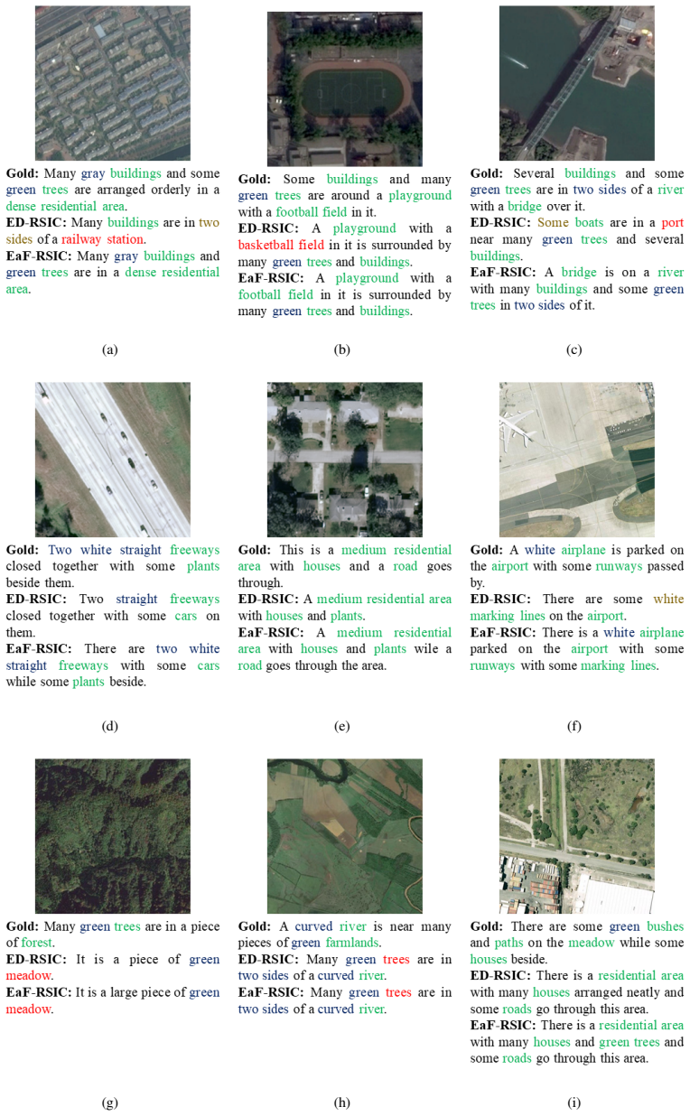
- [Figure 5] Figure 5: The qualitative caption examples would benefit from side-by-side ground-truth captions and explicit highlighting of where CBBS improves relevance over standard beam search.
Simulated Author's Rebuttal
We thank the referee for the positive review and recommendation of minor revision. The referee's summary accurately captures the core contributions of JSSFF, including the edge-aware fusion for improved boundary awareness in remote sensing images and the comparison-based beam search for balanced caption generation. We appreciate the recognition of the practical applicability to occlusion and edge challenges common in this domain.
Circularity Check
No significant circularity detected
full rationale
The manuscript describes an empirical encoder-decoder architecture for remote-sensing image captioning that incorporates an edge-aware fusion module and a comparison-based beam search decoder. No equations, derivations, or parameter-fitting steps are presented that reduce by construction to the inputs or to self-citations. The central claim of superiority is grounded in standard training and evaluation on external benchmarks, with no load-bearing self-referential definitions or imported uniqueness theorems. The work is therefore self-contained against external data.
Axiom & Free-Parameter Ledger
axioms (2)
- domain assumption Encoder-decoder frameworks are appropriate for image-to-text generation tasks
- domain assumption Edge-aware image versions improve feature representation for occluded or overlapping objects
Reference graph
Works this paper leans on
-
[1]
Deep semantic understanding of high resolution remote sensing image,
B. Qu, X. Li, D. Tao, and X. Lu, “Deep semantic understanding of high resolution remote sensing image,” in2016 International conference on computer, information and telecommunication systems (Cits), pp. 1–5, IEEE, 2016
2016
-
[2]
A new cnn-rnn framework for remote sensing image captioning,
G. Hoxha, F. Melgani, and J. Slaghenauffi, “A new cnn-rnn framework for remote sensing image captioning,” in2020 Mediterranean and Middle-East Geoscience and Remote Sensing Symposium (M2GARSS), pp. 1–4, IEEE, 2020
2020
-
[3]
Unveiling the power of con- volutional neural networks: A comprehensive study on remote sensing image captioning and encoder selection,
S. Das, A. Khandelwal, and R. Sharma, “Unveiling the power of con- volutional neural networks: A comprehensive study on remote sensing image captioning and encoder selection,” in2024 International Joint Conference on Neural Networks (IJCNN), pp. 1–8, IEEE, 2024
2024
-
[4]
A textgcn-based decoding approach for improv- ing remote sensing image captioning,
S. Das and R. Sharma, “A textgcn-based decoding approach for improv- ing remote sensing image captioning,”IEEE Geoscience and Remote Sensing Letters, 2024
2024
-
[5]
MsEdF: A Multi-stream Encoder-decoder Framework for Remote Sensing Image Captioning
S. Das and R. Sharma, “Fe-lws: Refined image-text representations via decoder stacking and fused encodings for remote sensing image captioning,”arXiv preprint arXiv:2502.09282, 2025
work page internal anchor Pith review Pith/arXiv arXiv 2025
-
[6]
A novel svm-based decoder for remote sens- ing image captioning,
G. Hoxha and F. Melgani, “A novel svm-based decoder for remote sens- ing image captioning,”IEEE Transactions on Geoscience and Remote Sensing, vol. 60, pp. 1–14, 2021
2021
-
[7]
Exploring models and data for remote sensing image caption generation,
X. Lu, B. Wang, X. Zheng, and X. Li, “Exploring models and data for remote sensing image caption generation,”IEEE Transactions on Geoscience and Remote Sensing, vol. 56, no. 4, pp. 2183–2195, 2017
2017
-
[8]
Correcting low-illumination images using multi-scale fusion in a pyramidal framework,
S. Das, M. Roy, and S. Mukhopadhyay, “Correcting low-illumination images using multi-scale fusion in a pyramidal framework,” in2020 In- ternational Conference on Wireless Communications Signal Processing and Networking (WiSPNET), pp. 126–129, IEEE, 2020
2020
-
[9]
A mask-guided transformer network with topic token for remote sensing image captioning,
Z. Ren, S. Gou, Z. Guo, S. Mao, and R. Li, “A mask-guided transformer network with topic token for remote sensing image captioning,”Remote Sensing, vol. 14, no. 12, p. 2939, 2022
2022
-
[10]
A novel lightweight trans- former with edge-aware fusion for remote sensing image captioning,
S. Das, D. Mundra, P. Dayal, and R. Sharma, “A novel lightweight trans- former with edge-aware fusion for remote sensing image captioning,” arXiv preprint arXiv:2506.09429, 2025
-
[11]
Image captioning with deep lstm based on sequential residual,
K. Xu, H. Wang, and P. Tang, “Image captioning with deep lstm based on sequential residual,” in2017 IEEE International Conference on Multimedia and Expo (ICME), pp. 361–366, IEEE, 2017
2017
-
[12]
Multi-scale cropping mecha- nism for remote sensing image captioning,
X. Zhang, Q. Wang, S. Chen, and X. Li, “Multi-scale cropping mecha- nism for remote sensing image captioning,” inIGARSS 2019-2019 IEEE International Geoscience and Remote Sensing Symposium, pp. 10039– 10042, IEEE, 2019
2019
-
[13]
Correcting low illumination im- ages using pso-based gamma correction and image classifying method,
S. Das, M. Roy, and S. Mukhopadhyay, “Correcting low illumination im- ages using pso-based gamma correction and image classifying method,” inInternational Conference on Computer Vision and Image Processing, pp. 433–444, Springer, 2020
2020
-
[14]
Image captioning using cnn and lstm,
G. Sairam, M. Mandha, P. Prashanth, and P. Swetha, “Image captioning using cnn and lstm,” in4th Smart cities symposium (SCS 2021), vol. 2021, pp. 274–277, IET, 2021
2021
-
[15]
A joint-training two-stage method for remote sensing image captioning,
X. Ye, S. Wang, Y . Gu, J. Wang, R. Wang, B. Hou, F. Giunchiglia, and L. Jiao, “A joint-training two-stage method for remote sensing image captioning,”IEEE Transactions on Geoscience and Remote Sensing, vol. 60, pp. 1–16, 2022
2022
-
[16]
Improving image captioning systems with postprocessing strategies,
G. Hoxha, G. Scuccato, and F. Melgani, “Improving image captioning systems with postprocessing strategies,”IEEE Transactions on Geo- science and Remote Sensing, vol. 61, pp. 1–13, 2023
2023
-
[17]
Show, observe and tell: Attribute-driven attention model for image captioning.,
H. Chen, G. Ding, Z. Lin, S. Zhao, and J. Han, “Show, observe and tell: Attribute-driven attention model for image captioning.,” inIJCAI, pp. 606–612, 2018
2018
-
[18]
A multi-level attention model for remote sensing image captions,
Y . Li, S. Fang, L. Jiao, R. Liu, and R. Shang, “A multi-level attention model for remote sensing image captions,”Remote Sensing, vol. 12, no. 6, p. 939, 2020
2020
-
[19]
Multi-label semantic feature fusion for remote sensing image captioning,
S. Wang, X. Ye, Y . Gu, J. Wang, Y . Meng, J. Tian, B. Hou, and L. Jiao, “Multi-label semantic feature fusion for remote sensing image captioning,”ISPRS Journal of Photogrammetry and Remote Sensing, vol. 184, pp. 1–18, 2022
2022
-
[20]
Transforming remote sensing images to textual descriptions,
U. Zia, M. M. Riaz, and A. Ghafoor, “Transforming remote sensing images to textual descriptions,”International Journal of Applied Earth Observation and Geoinformation, vol. 108, p. 102741, 2022
2022
-
[21]
A convnet for the 2020s,
Z. Liu, H. Mao, C.-Y . Wu, C. Feichtenhofer, T. Darrell, and S. Xie, “A convnet for the 2020s,” inProceedings of the IEEE/CVF conference on computer vision and pattern recognition, pp. 11976–11986, 2022
2022
-
[22]
S. Das, S. Gupta, K. Kumar, and R. Sharma, “Good representation, better explanation: Role of convolutional neural networks in transformer-based remote sensing image captioning,”arXiv preprint arXiv:2502.16095, 2025
-
[23]
A computational approach to edge detection,
J. Canny, “A computational approach to edge detection,”IEEE Transac- tions on pattern analysis and machine intelligence, no. 6, pp. 679–698, 1986
1986
-
[24]
A 3x3 isotropic gradient operator for image processing,
I. Sobel, G. Feldman,et al., “A 3x3 isotropic gradient operator for image processing,”a talk at the Stanford Artificial Project in, vol. 1968, pp. 271–272, 1968
1968
-
[25]
Theory of edge detection,
D. Marr and E. Hildreth, “Theory of edge detection,”Proceedings of the Royal Society of London. Series B. Biological Sciences, vol. 207, no. 1167, pp. 187–217, 1980
1980
-
[26]
Sequence to sequence learning with neural networks,
I. Sutskever, O. Vinyals, and Q. V . Le, “Sequence to sequence learning with neural networks,” inAdvances in neural information processing systems, pp. 3104–3112, 2014
2014
-
[27]
Neural Machine Translation by Jointly Learning to Align and Translate
D. Bahdanau, K. Cho, and Y . Bengio, “Neural machine translation by jointly learning to align and translate,”arXiv preprint arXiv:1409.0473, 2014
work page internal anchor Pith review arXiv 2014
-
[28]
Bleu: a method for automatic evaluation of machine translation,
K. Papineni, S. Roukos, T. Ward, and W.-J. Zhu, “Bleu: a method for automatic evaluation of machine translation,” inProceedings of the 40th Annual Meeting of the Association for Computational Linguistics, (Philadelphia, Pennsylvania, USA), pp. 311–318, Association for Com- putational Linguistics, July 2002
2002
-
[29]
METEOR: An automatic metric for MT evaluation with high levels of correlation with human judgments,
A. Lavie and A. Agarwal, “METEOR: An automatic metric for MT evaluation with high levels of correlation with human judgments,” in Proceedings of the Second Workshop on Statistical Machine Translation, (Prague, Czech Republic), pp. 228–231, Association for Computational Linguistics, June 2007
2007
-
[30]
ROUGE: A package for automatic evaluation of summaries,
C.-Y . Lin, “ROUGE: A package for automatic evaluation of summaries,” inText Summarization Branches Out, (Barcelona, Spain), pp. 74–81, Association for Computational Linguistics, July 2004
2004
-
[31]
Cider: Consensus- based image description evaluation,
R. Vedantam, C. Lawrence Zitnick, and D. Parikh, “Cider: Consensus- based image description evaluation,” inProceedings of the IEEE confer- ence on computer vision and pattern recognition, pp. 4566–4575, 2015
2015
-
[32]
Semantic descriptions of high-resolution remote sensing images,
B. Wang, X. Lu, X. Zheng, and X. Li, “Semantic descriptions of high-resolution remote sensing images,”IEEE Geoscience and Remote Sensing Letters, vol. 16, no. 8, pp. 1274–1278, 2019
2019
-
[33]
Trtr-cmr: Cross- modal reasoning dual transformer for remote sensing image captioning,
Y . Wu, L. Li, L. Jiao, F. Liu, X. Liu, and S. Yang, “Trtr-cmr: Cross- modal reasoning dual transformer for remote sensing image captioning,” IEEE Transactions on Geoscience and Remote Sensing, 2024
2024
discussion (0)
Sign in with ORCID, Apple, or X to comment. Anyone can read and Pith papers without signing in.