Recognition: no theorem link
An Object-Oriented Spatial Statistics Approach for Human Activity Space Estimation
Pith reviewed 2026-05-12 00:58 UTC · model grok-4.3
The pith
A time-weighted estimator using time distributions over GIS polygons and roads estimates human activity spaces from irregular GPS data.
A machine-rendered reading of the paper's core claim, the machinery that carries it, and where it could break.
Core claim
By characterizing daily mobility through the distribution of time across spatial polygons and road segments within the object-oriented spatial statistics framework, the time-weighted estimator recovers concentrated stationary anchors, interpretable travel corridors, and distinct stabilization behavior for dwelling and movement components from irregularly sampled GPS data, while the error bound quantifies effects of measurement error, nearest-entity misclassification, temporal gaps, boundary crossings, and day-to-day variability.
What carries the argument
The time-weighted estimator applied to the distribution of time across GIS polygons and road segments, which carries the estimation of entity-specific activity spaces and the error bound.
Load-bearing premise
That time distributions across spatial polygons and road segments, combined with the object-oriented framework, sufficiently capture entity-specific mobility patterns and that the derived error bound accurately accounts for all listed sources of variability without additional conditions on data quality or sampling.
What would settle it
A controlled GPS dataset with known true activity spaces in which the estimator fails to recover the stationary anchors or the observed discrepancies exceed the derived error bound when temporal gaps or measurement errors are present.
Figures


read the original abstract
Human activity spaces are shaped by individual mobility and the built environment, motivating statistical methods that integrate GPS observations with GIS representations of places and routes. We propose a novel methodology to estimate activity spaces in built environments from GPS data within the Object Oriented Spatial Statistics framework. We characterize daily mobility through the distribution of time across spatial polygons and road segments, aiming to capture entity-specific time-use fractions and level-$\gamma$ activity spaces. We develop a time-weighted estimator to handle irregularly sampled GPS observations. We derive an error bound that quantifies the effects of measurement error, nearest-entity misclassification, temporal gaps, boundary crossings, and day-to-day variability. We also develop a map-augmented representation of daily activity patterns, a dwell-time-weighted distance for clustering daily trajectories, and polygon- and road-based stability summaries. Simulation studies and a real-data application demonstrate that the proposed framework recovers concentrated stationary anchors, interpretable travel corridors, and distinct stabilization behavior for dwelling and movement components, supporting the benefits of weighting under irregular sampling. KEYWORDS: GPS data, GIS, human mobility, space-time geography.
Editorial analysis
A structured set of objections, weighed in public.
Referee Report
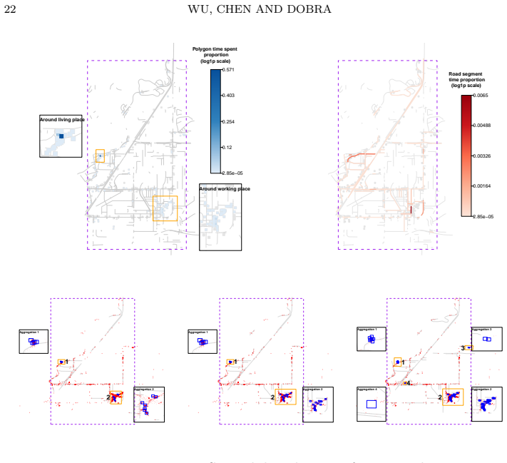
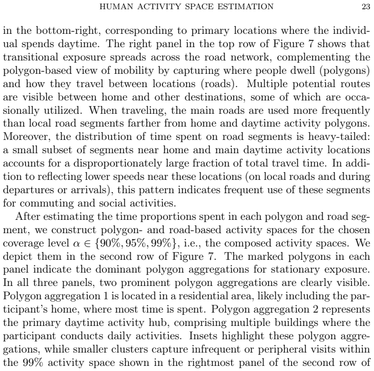
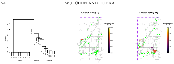
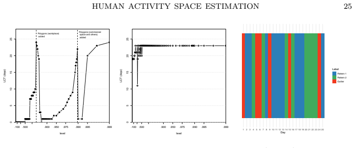
Summary. The paper proposes an object-oriented spatial statistics framework for estimating human activity spaces from irregularly sampled GPS data integrated with GIS representations of polygons and road segments. It characterizes daily mobility via time distributions across these objects to capture entity-specific time-use fractions and level-γ activity spaces, introduces a time-weighted estimator, derives an error bound quantifying measurement error, nearest-entity misclassification, temporal gaps, boundary crossings, and day-to-day variability, and develops map-augmented daily patterns, dwell-time-weighted distances for clustering, and polygon/road-based stability summaries. Simulation studies and a real-data application are presented to show recovery of concentrated stationary anchors, interpretable travel corridors, and distinct stabilization for dwelling versus movement components.
Significance. If the error bound is shown to be rigorous and the time-weighted estimator demonstrably improves recovery under irregular sampling, the work offers a principled way to fuse GPS trajectories with GIS objects for activity-space estimation, with potential utility in mobility research and urban planning. The combination of a derived bound with empirical validation on both simulated and real data is a positive feature; the object-oriented framing may also aid interpretability of entity-specific patterns.
major comments (1)
- [Error-bound derivation (methods section)] The central claim rests on the time-weighted estimator together with a derived error bound that 'quantifies the effects' of the five listed sources of variability (measurement error, misclassification, gaps, boundary crossings, day-to-day variability). The abstract provides no indication that the bound incorporates covariance terms or spatial dependence induced by GIS polygons and segments (e.g., GPS error near boundaries simultaneously inflating both measurement error and misclassification). If the bound is obtained via separate first-order expansions or simulation-calibrated constants without explicit regularity conditions on sampling density and GIS resolution, the total error can exceed the stated bound once autocorrelation or boundary effects are present. This directly affects whether the framework can be said to accurately account for all listed sources.
minor comments (2)
- [Abstract] The abstract introduces 'level-γ activity spaces' without defining γ or its interpretation; a short clarification in the abstract or introduction would improve accessibility.
- [Keywords] The keywords list omits 'activity space' and 'object-oriented statistics'; adding these would aid discoverability.
Simulated Author's Rebuttal
We thank the referee for the careful and constructive review of our manuscript. The single major comment raises a valid point about the rigor of the error-bound derivation with respect to spatial dependence and regularity conditions. We address this below and indicate the revisions we will make.
read point-by-point responses
-
Referee: The central claim rests on the time-weighted estimator together with a derived error bound that 'quantifies the effects' of the five listed sources of variability (measurement error, misclassification, gaps, boundary crossings, day-to-day variability). The abstract provides no indication that the bound incorporates covariance terms or spatial dependence induced by GIS polygons and segments (e.g., GPS error near boundaries simultaneously inflating both measurement error and misclassification). If the bound is obtained via separate first-order expansions or simulation-calibrated constants without explicit regularity conditions on sampling density and GIS resolution, the total error can exceed the stated bound once autocorrelation or boundary effects are present. This directly affects whether the framework can be said to accurately account for all listed sources.
Authors: We appreciate the referee's observation on potential spatial dependence. The error bound is derived in the methods section by applying first-order expansions to each of the five sources individually and then aggregating them conservatively via the triangle inequality; this produces an upper bound that does not require explicit covariance modeling but is intended to remain valid under bounded dependence induced by the GIS geometry. We acknowledge that the manuscript does not currently state the necessary regularity conditions on sampling density and GIS resolution, nor does it explicitly discuss how boundary-induced autocorrelation is absorbed into the misclassification term. We will revise the methods section to add these conditions, include a short remark on the conservative nature of the bound, and expand the simulation studies to report empirical coverage under scenarios with induced spatial autocorrelation near polygon boundaries. revision: partial
Circularity Check
No circularity: estimator and error bound presented as derived from framework with independent validation
full rationale
The abstract and available text describe a time-weighted estimator developed to handle irregular GPS sampling and an error bound derived to quantify effects of measurement error, misclassification, gaps, boundary crossings, and day-to-day variability within the object-oriented spatial statistics framework. These are introduced as novel methodological contributions, followed by simulation studies and real-data application that demonstrate recovery of anchors and corridors. No equations or steps are shown that reduce the estimator or bound to fitted inputs by construction, self-definitional loops, or load-bearing self-citations. The derivation chain is presented as self-contained, with external validation via simulations rather than tautological renaming or ansatz smuggling. This is the expected non-finding for a methods paper whose central claims rest on explicit construction and empirical checks rather than circular reductions.
Axiom & Free-Parameter Ledger
free parameters (1)
- level-gamma
axioms (2)
- domain assumption GPS observations can be mapped to spatial polygons and road segments to represent time-use fractions.
- domain assumption Irregular GPS sampling can be corrected via time-weighting without introducing bias beyond the quantified error bound.
Reference graph
Works this paper leans on
-
[1]
Baddeley, Gopalan Nair, Suman Rakshit, Greg McSwiggan, and Tilman M
A. Baddeley, Gopalan Nair, Suman Rakshit, Greg McSwiggan, and Tilman M. Davies. Analysing point patterns on networks — A review. Spatial Statistics, 42: 0 100435, 2021. Towards Spatial Data Science
work page 2021
-
[2]
David Berrigan, J. Aaron Hipp, Philip M. Hurvitz, Peter James, Marta M. Jankowska, Jacqueline Kerr, Francine Laden, Tammy Leonard, Robin A. McKinnon, Tiffany M. Powell-Wiley, Elizabeth Tarlov, Shannon N. Zenk, and The TREC Spatial and Contextual, Measures and Modeling Work Group . Geospatial and contextual approaches to energy balance and health. Annals o...
work page 2015
-
[3]
Stacey Bricka and Chandra R. Bhat. Comparative Analysis of Global Positioning System – Based and Travel Survey – Based Data . Transportation Research Record, 1972 0 (1): 0 9--20, January 2006. ISSN 0361-1981. doi:10.1177/0361198106197200102. URL https://doi.org/10.1177/0361198106197200102. Publisher: SAGE Publications Inc
-
[4]
Urban form and household activity-travel behavior
Ron N Buliung and Pavlos S Kanaroglou. Urban form and household activity-travel behavior. Growth and Change, 37 0 (2): 0 172--199, 2006
work page 2006
-
[5]
Measuring human activity spaces from gps data with density ranking and summary curves
Yen-Chi Chen and Adrian Dobra. Measuring human activity spaces from gps data with density ranking and summary curves. Annals of Applied Statistics, 14 0 (1): 0 409--432, 2020
work page 2020
-
[6]
N. Cressie, J. Frey, B. Harck, and M. Smith. Spatial prediction on a river network. Journal of Agricultural, Biological and Environmental Statistics, 11: 0 127--150, 2006
work page 2006
-
[7]
A statistical framework for measuring the temporal stability of human mobility patterns
Zhihang Dong, Yen-Chi Chen, and Adrian Dobra. A statistical framework for measuring the temporal stability of human mobility patterns. Journal of Applied Statistics, 48 0 (1): 0 105--123, 2021. doi:10.1080/02664763.2019.1711363. URL https://doi.org/10.1080/02664763.2019.1711363
- [8]
-
[9]
Urban form, individual spatial footprints, and travel: Examination of space-use behavior
Yingling Fan and Asad J Khattak. Urban form, individual spatial footprints, and travel: Examination of space-use behavior. Transportation Research Record, 2082 0 (1): 0 98--106, 2008
work page 2082
-
[10]
A. S. Fotheringham and P. A. Rogerson. The M odifiable A real U nit P roblem ( M A U P ). In The SAGE handbook of spatial analysis, pages 105--124. Sage, 2008
work page 2008
-
[11]
R. G. Golledge. Human wayfinding and cognitive maps. In R. G. Golledge, editor, Wayfinding Behavior, pages 5--45. The Johns Hopkins University Press, Baltimore, 1999
work page 1999
-
[12]
R. G. Golledge and R. J. Stimson. Spatial Behavior. The Guildford Press, New York, 1997
work page 1997
-
[13]
T. H\" a gerstrand. What about people in regional science? Papers of the Regional Science Association, 24: 0 7--21, 1970
work page 1970
-
[14]
Abel, Alessandro Sorichetta, Arkadius Wi'sniowski, Ingmar Weber, and Andrew J
Christina Hughes, Emilio Zagheni, Guy J. Abel, Alessandro Sorichetta, Arkadius Wi'sniowski, Ingmar Weber, and Andrew J. Tatem. Inferring Migrations : Traditional Methods and New Approaches based on Mobile Phone , Social Media , and other Big Data : Feasibility study on Inferring (labour) mobility and migration in the European Union from big data and socia...
work page 2016
-
[15]
Malia Jones and Anne R. Pebley. Redefining neighborhoods using common destinations: social characteristics of activity spaces and home census tracts compared. Demography, 51 0 (3): 0 727--752, June 2014. ISSN 0070-3370. doi:10.1007/s13524-014-0283-z
-
[16]
The uncertain geographic context problem
Mei-Po Kwan. The uncertain geographic context problem. Annals of the Association of American Geographers, 102: 0 958--968, 2012
work page 2012
-
[17]
Mei-Po Kwan. Beyond space (as we knew it): Toward temporally integrated geographies of segregation, health, and accessibility. Annals of the Association of American Geographers, 103: 0 1078--1086, 2013
work page 2013
-
[18]
Alexandru M. Lapadat, Christian C. J. M. Tiberius, and Peter J. G. Teunissen. Experimental evaluation of smartphone accelerometer and low-cost dual frequency gnss sensors for deformation monitoring. Sensors, 21 0 (23): 0 7946, 2021. doi:10.3390/s21237946
-
[19]
Vladimir I. Levenshtein. Binary codes capable of correcting deletions, insertions, and reversals. Soviet Physics Doklady, 10 0 (8): 0 707--710, 1966. Originally published in Doklady Akademii Nauk SSSR, 163:845–848 (1965)
work page 1966
-
[20]
Map-matching for low-sampling-rate gps trajectories
Yin Lou, Chengyang Zhang, Xing Xie, Yu Zheng, Wei Wang, and Yan Huang. Map-matching for low-sampling-rate gps trajectories. In Proceedings of 18th ACM SIGSPATIAL Conference on Advances in Geographical Information Systems, November 2009. URL https://www.microsoft.com/en-us/research/publication/map-matching-for-low-sampling-rate-gps-trajectories/
work page 2009
-
[21]
S. A. Matthews and T.-C. Yang. Spatial polygamy and contextual exposures ( S P A C E s): Promoting activity space approaches in research on place and health. The American Behavioral Scientist, 57: 0 1057--1081, 2013
work page 2013
-
[22]
J. D. Mazimpaka and S. Timpf. Trajectory data mining: A review of methods and applications. Journal of Spatial Information Science, 13: 0 61--99, 2016
work page 2016
-
[23]
A. Menafoglio and P. Secchi. Statistical analysis of complex and spatially dependent data: A review of O bject O riented S patial S tatistics. European Journal of Operations Research, 258: 0 401--410, 2017
work page 2017
-
[24]
Tracy H Newsome, Wayne A Walcott, and Paul D Smith. Urban activity spaces: Illustrations and application of a conceptual model for integrating the time and space dimensions. Transportation, 25 0 (4): 0 357--377, 1998
work page 1998
-
[25]
Hidden markov map matching through noise and sparseness
Paul Newson and John Krumm. Hidden markov map matching through noise and sparseness. In 17th ACM SIGSPATIAL International Conference on Advances in Geographic Information Systems (ACM SIGSPATIAL GIS 2009), November 4-6, Seattle, WA, pages 336--343, November 2009. URL https://www.microsoft.com/en-us/research/publication/hidden-markov-map-matching-noise-sparseness/
work page 2009
-
[26]
Spatial Analysis along Networks
Atsuyuki Okabe and Kokichi Sugihara. Spatial Analysis along Networks. John Wiley and Sons, Ltd, 2012. ISBN 9781119967101. doi:https://doi.org/10.1002/9781119967101.fmatter. URL https://onlinelibrary.wiley.com/doi/abs/10.1002/9781119967101.fmatter
-
[27]
Kristen Olson, James Wagner, and Raeda Anderson. Survey Costs : Where are We and What is the Way Forward ? Journal of Survey Statistics and Methodology, 9 0 (5): 0 921--942, November 2021. ISSN 2325-0984. doi:10.1093/jssam/smaa014. URL https://doi.org/10.1093/jssam/smaa014
-
[28]
Dgps enhancement to gps nmea output data: Dgps by correction projection to position-domain
Byungwoon Park, Jeongkeun Lee, Younsil Kim, Ho Yun, and Changdon Kee. Dgps enhancement to gps nmea output data: Dgps by correction projection to position-domain. The Journal of Navigation, 66 0 (2): 0 249--264, 2013. doi:10.1017/S0373463312000471
-
[29]
Spatial Data Science With Applications in R
Edzer Pebesma and Roger Bivand. Spatial Data Science With Applications in R. Chapman and Hall/CRC, New York, 2023
work page 2023
-
[30]
Camille Perchoux, Basile Chaix, Steven Cummins, and Yan Kestens. Conceptualization and measurement of environmental exposure in epidemiology: Accounting for activity space related to daily mobility. Health & Place, 21: 0 86--93, 2013
work page 2013
-
[31]
Nolan E. Phillips, Brian L. Levy, Robert J. Sampson, Mario L. Small, and Ryan Q. Wang. The Social Integration of American Cities : Network Measures of Connectedness Based on Everyday Mobility Across Neighborhoods . Sociological Methods & Research, 50 0 (3): 0 1110--1149, August 2021. ISSN 0049-1241. doi:10.1177/0049124119852386. URL https://doi.org/10.117...
-
[32]
Why gps makes distances bigger than they are
Peter Ranacher, Richard Brunauer, Wolfgang Trutschnig, Stefan Van der Spek, and Siegfried Reich. Why gps makes distances bigger than they are. International Journal of Geographical Information Science, 30: 0 316--333, 2016
work page 2016
-
[33]
Douglas B. Richardson, Nora D. Volkow, Mei-Po Kwan, Robert M. Kaplan, Michael F. Goodchild, and Robert T. Croyle. Spatial turn in health research. Science, 339: 0 1390--1392, 2013
work page 2013
- [34]
-
[35]
Schneider, Vitaly Belik, Thomas Couronn \'e , Zbigniew Smoreda, and Marta C
Christian M. Schneider, Vitaly Belik, Thomas Couronn \'e , Zbigniew Smoreda, and Marta C. Gonz \'a lez. Unravelling daily human mobility motifs. Journal of The Royal Society Interface, 10 0 (84): 0 20130246, 2013. doi:10.1098/rsif.2013.0246
-
[36]
S. Sch\" o nfelder and K. W. Axhausen. Activity spaces: measures of social exclusion? Transport Policy, 10: 0 273--286, 2003
work page 2003
-
[37]
S. Sch\" o nfelder and K. W. Axhausen. On the variability of human activity spaces. In Martina Koll-Schretzenmayr, Marco Keiner, and Gustav Nussbaumer, editors, The Real and Virtual Worlds of Spatial Planning, pages 237--262. Springer Verlag, Berlin, Heidelberg, 2004
work page 2004
-
[38]
A suite of methods for representing activity space in a healthcare accessibility study
Jill E Sherman, John Spencer, John S Preisser, Wilbert M Gesler, and Thomas A Arcury. A suite of methods for representing activity space in a healthcare accessibility study. International journal of health geographics, 4 0 (1): 0 1--21, 2005
work page 2005
-
[39]
G lobal P ositioning S ystem S tandard P ositioning S ervice P erformance S tandard (5th ed.), 2020
United States Government . G lobal P ositioning S ystem S tandard P ositioning S ervice P erformance S tandard (5th ed.), 2020. URL https://www.gps.gov/technical/ps/2020-SPS-performance-standard.pdf
work page 2020
-
[40]
Qi Wang, Nolan Edward Phillips, Mario L. Small, and Robert J. Sampson. Urban mobility and neighborhood isolation in America ’s 50 largest cities. Proceedings of the National Academy of Sciences of the United States of America, 115 0 (30): 0 7735--7740, July 2018. ISSN 0027-8424. doi:10.1073/pnas.1802537115. URL https://www.ncbi.nlm.nih.gov/pmc/articles/PM...
-
[41]
S. E. Wiehe, M. P. Kwan, J. Wilson, and J. D. Fortenberry. Adolescent health-risk behavior and community disorder. PloS One, 8: 0 e77667, 2013
work page 2013
-
[42]
David W. S. Wong and Shih-Lung Shaw. Measuring segregation: an activity space approach. Journal of geographical systems, 13 0 (2): 0 127--145, June 2011. ISSN 1435-5930. doi:10.1007/s10109-010-0112-x. URL https://www.ncbi.nlm.nih.gov/pmc/articles/PMC3106997/
-
[43]
A statistical framework for analyzing activity pattern from gps data, 2025
Haoyang Wu, Yen-Chi Chen, and Adrian Dobra. A statistical framework for analyzing activity pattern from gps data, 2025. URL https://arxiv.org/abs/2504.04316
-
[44]
H. Yang et al. Exploring human mobility: A time-informed approach to pattern mining and sequence similarity. International Journal of Geographical Information Science, 2025. Discusses sequence similarity measures including edit distance, LCS, DTW for human mobility patterns
work page 2025
-
[45]
Demographic research with non-representative internet data
Emilio Zagheni and Ingmar Weber. Demographic research with non-representative internet data. International Journal of Manpower, 36 0 (1): 0 13--25, January 2015. ISSN 0143-7720. doi:10.1108/IJM-12-2014-0261. URL https://doi.org/10.1108/IJM-12-2014-0261. Publisher: Emerald Group Publishing Limited
-
[46]
S. N. Zenk, A. J. Schulz, S. A. Matthews, A. Odoms- Y oung, J. Wilbur, L. Wegrzyn, K. Gibbs, C. Braunschweig, and C. Stokes. Activity space environment and dietary and physical activity behaviors: a pilot study. Health & Place, 17: 0 1150--1161, 2011
work page 2011
-
[47]
W. Zhai et al. Detecting and clustering patterns of human activities using an augmented space–time-weighted edit distance method. Transportation Research Part C, 2019. Introduces weighted edit distance approaches to trajectory similarity
work page 2019
discussion (0)
Sign in with ORCID, Apple, or X to comment. Anyone can read and Pith papers without signing in.