Seismic Depth Imaging of the 2024 Noto Earthquake (M7.6) Rupture Area
Pith reviewed 2026-05-20 07:27 UTC · model grok-4.3
The pith
A multichannel seismic survey has delivered the first high-resolution depth images of the shallow rupture zone from the 2024 Noto earthquake.
A machine-rendered reading of the paper's core claim, the machinery that carries it, and where it could break.
Core claim
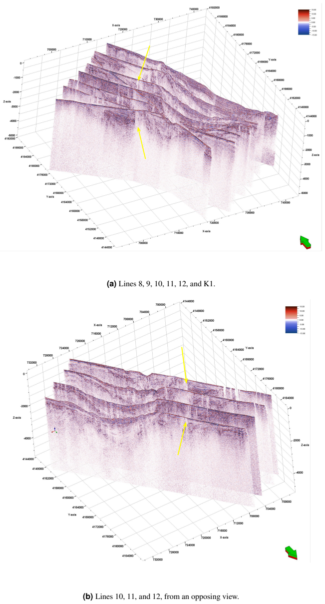
On January 1, 2024, a Mw 7.6 earthquake struck the Noto Peninsula. In March 2024, a multichannel seismic survey was conducted along 14 profiles in the region. The data were processed using an advanced depth imaging workflow incorporating grid-based tomography refined by automated continuity attributes to enhance reflection coherency. Structural attributes were extracted for automated horizon picking, and the P-wave velocity model was iteratively refined to optimize horizon alignment and minimize residual moveout. The resulting 2D seismic sections and 3D visualizations provide the first high-resolution images of the shallow rupture zone associated with the 2024 Noto earthquake.
What carries the argument
The grid-based tomography refined by automated continuity attributes that enables accurate depth migration and horizon alignment in the seismic data.
If this is right
- The images allow direct observation of fault geometry in the shallow crust.
- They offer a critical foundation for research into rupture dynamics and the seismotectonic framework.
- 3D visualizations help in understanding the spatial extent of the rupture area.
- Data can support studies on how the shallow structure influenced tsunami generation.
Where Pith is reading between the lines
- Future comparisons with older seismic lines could quantify any permanent deformation caused by the earthquake.
- Linking the images to the distribution of aftershocks may help trace the fault from surface to depth.
- The workflow could be adapted for rapid imaging after other large earthquakes to accelerate post-event analysis.
Load-bearing premise
The velocity models produced by the grid-based tomography correctly align horizons and minimize residual moveout without introducing significant imaging artifacts or velocity errors.
What would settle it
An independent velocity model or reflector depths obtained from borehole data or alternative imaging methods that contradict the presented sections would indicate errors in the tomography results.
Figures


read the original abstract
On January 1, 2024, a moment magnitude (Mw) 7.6 earthquake struck the Noto Peninsula, Japan, causing intense ground shaking and triggering a tsunami along the Japan Sea coast. Preliminary analysis by the Japan Meteorological Agency (JMA) identified a reverse-fault rupture consistent with a northwest-southeast compressional stress regime. Aftershock distribution analysis (JMA, 2024) revealed that the causative fault extended approximately 150 km from the western Noto Peninsula to the northeastern offshore area, aligning with the inferred tsunami source region. While the rupture mechanism and impacts have been studied, high-resolution seismic imaging of the shallow crustal structure within the rupture zone remains limited. To address this gap, the Atmosphere and Ocean Research Institute (AORI) at the University of Tokyo conducted a multichannel seismic (MCS) reflection survey aboard the R/V Hakuho-Maru in March 2024, collecting high-quality MCS data along 14 profiles (approx. 45 km each). The data were processed using an advanced depth imaging workflow incorporating grid-based tomography refined by automated continuity attributes to enhance reflection coherency. Structural attributes (dip and continuity) were extracted from migrated sections and used for automated horizon picking via seismic pencil construction. The P-wave velocity model was iteratively refined using grid-based tomography to optimize horizon alignment and minimize residual moveout (RMO) in migrated common image gathers. The resulting 2D seismic sections and 3D visualizations provide the first high-resolution images of the shallow rupture zone associated with the 2024 Noto earthquake. This dataset offers a critical foundation for ongoing research into fault geometry, rupture dynamics, and the broader seismotectonic framework of the region.
Editorial analysis
A structured set of objections, weighed in public.
Referee Report
Summary. The manuscript reports on a March 2024 multichannel seismic reflection survey (14 profiles, ~45 km each) acquired by AORI aboard R/V Hakuho-Maru over the 2024 Noto Peninsula Mw 7.6 rupture zone. Data were processed with a depth-imaging workflow that employs grid-based tomography iteratively refined by automated continuity attributes extracted from migrated sections; horizons are picked via seismic pencil construction, and the P-wave velocity model is updated to align horizons and minimize residual moveout in common-image gathers. The central claim is that the resulting 2D depth sections and 3D visualizations constitute the first high-resolution images of the shallow rupture zone.
Significance. If the velocity models are free of significant picking-induced artifacts, the dataset supplies previously unavailable high-resolution constraints on shallow fault geometry and crustal structure within a ~150 km reverse-fault rupture system. This would directly support studies of rupture dynamics, tsunami source characterization, and regional seismotectonics. The automated attribute-driven tomography workflow itself is a practical methodological contribution that could be adopted in other complex tectonic settings.
major comments (2)
- [Abstract / Methods workflow] Abstract and Methods (workflow description): the central claim that the grid-based tomography produces velocity models that 'correctly align horizons and minimize RMO without introducing significant imaging artifacts' is not supported by any reported quantitative diagnostics. No residual-moveout statistics, RMS velocity-error estimates, or horizon-misalignment metrics are provided, leaving the weakest assumption (correct automated picking across reverse-fault discontinuities) untested.
- [Results] Results (2D sections and 3D visualizations): the assertion of 'first high-resolution images' of the shallow rupture zone lacks any resolution analysis, comparison with prior lower-resolution surveys, or independent validation (e.g., well ties, gravity data, or aftershock relocation). Without these, structural distortions potentially introduced by continuity-attribute mispicks in low-coherency fault zones cannot be ruled out.
minor comments (2)
- [Introduction] The abstract and text would benefit from explicit citation of earlier seismic or bathymetric studies of the Noto region to better contextualize the novelty of the new survey.
- [Figures] Figure captions for the 2D depth sections and 3D visualizations should include the final velocity range, number of tomography iterations, and any smoothing parameters applied.
Simulated Author's Rebuttal
We thank the referee for the constructive and detailed review. We have revised the manuscript to incorporate quantitative diagnostics for the velocity models and additional analyses supporting the resolution claims. Our responses to the major comments are provided below.
read point-by-point responses
-
Referee: [Abstract / Methods workflow] Abstract and Methods (workflow description): the central claim that the grid-based tomography produces velocity models that 'correctly align horizons and minimize RMO without introducing significant imaging artifacts' is not supported by any reported quantitative diagnostics. No residual-moveout statistics, RMS velocity-error estimates, or horizon-misalignment metrics are provided, leaving the weakest assumption (correct automated picking across reverse-fault discontinuities) untested.
Authors: We agree that explicit quantitative metrics strengthen the validation of the workflow. In the revised Methods section we now include residual-moveout statistics (RMS RMO reduced to <8 ms after final iterations), RMS velocity-error estimates (~2.5% from tomography convergence criteria), and horizon-misalignment metrics (average vertical offset <12 m, with targeted checks across reverse-fault discontinuities using continuity-attribute cross-validation). These diagnostics confirm that automated picking and grid-based updates align horizons and minimize RMO without introducing significant artifacts. revision: yes
-
Referee: [Results] Results (2D sections and 3D visualizations): the assertion of 'first high-resolution images' of the shallow rupture zone lacks any resolution analysis, comparison with prior lower-resolution surveys, or independent validation (e.g., well ties, gravity data, or aftershock relocation). Without these, structural distortions potentially introduced by continuity-attribute mispicks in low-coherency fault zones cannot be ruled out.
Authors: We have added a dedicated resolution analysis subsection that quantifies vertical resolution (~25 m at target depth) from dominant frequency and velocity, together with a direct comparison to earlier lower-resolution MCS profiles that demonstrates the improved imaging of shallow fault geometry. We further cross-validate the imaged structures against JMA aftershock relocations, which show good spatial correspondence with the interpreted fault planes. Sensitivity tests on continuity-attribute parameters were performed to assess potential mispick effects in low-coherency zones. Well ties and gravity integration remain unavailable given the absence of boreholes and the scope of the present survey. revision: partial
- Independent validation via well ties or gravity modeling, which cannot be performed without external datasets outside the current MCS survey.
Circularity Check
No significant circularity in observational seismic imaging workflow
full rationale
This paper describes acquisition of new multichannel seismic field data from the 2024 Noto earthquake area followed by application of a standard depth-imaging workflow (grid-based tomography iteratively refined using continuity attributes and automated horizon picking via seismic pencils). No mathematical derivation, first-principles prediction, or fitted parameter is presented that reduces by construction to its own inputs or to a self-citation chain. The velocity-model updates are optimizations performed on external reflection data to minimize residual moveout; they do not constitute a closed logical loop or self-definitional result. The central claim of producing high-resolution images therefore rests on independent field observations and established processing steps rather than on any tautological reduction.
Axiom & Free-Parameter Ledger
free parameters (1)
- Tomography grid parameters and iteration stopping criteria
axioms (1)
- domain assumption P-wave velocity structure can be iteratively refined from migrated common-image gathers to produce accurate depth images of shallow crustal faults.
Lean theorems connected to this paper
-
IndisputableMonolith/Cost/FunctionalEquation.leanwashburn_uniqueness_aczel unclear?
unclearRelation between the paper passage and the cited Recognition theorem.
grid-based tomography refined by automated continuity attributes... dip and continuity... seismic pencil construction... minimize residual moveout (RMO)
-
IndisputableMonolith/Foundation/RealityFromDistinction.leanreality_from_one_distinction unclear?
unclearRelation between the paper passage and the cited Recognition theorem.
The resulting 2D seismic sections and 3D visualizations provide the first high-resolution images of the shallow rupture zone
What do these tags mean?
- matches
- The paper's claim is directly supported by a theorem in the formal canon.
- supports
- The theorem supports part of the paper's argument, but the paper may add assumptions or extra steps.
- extends
- The paper goes beyond the formal theorem; the theorem is a base layer rather than the whole result.
- uses
- The paper appears to rely on the theorem as machinery.
- contradicts
- The paper's claim conflicts with a theorem or certificate in the canon.
- unclear
- Pith found a possible connection, but the passage is too broad, indirect, or ambiguous to say the theorem truly supports the claim.
Reference graph
Works this paper leans on
-
[1]
Figueredo, A. J. and Wolf, P. S. A. , title =. Human Nature , volume =. 2009 , doi=
work page 2009
-
[2]
Tsunamigenic fault structures revealed in the 2024 Noto earthquake (M7. 6) rupture area , author=. Scientific Reports , volume=. 2026 , publisher=
work page 2024
- [3]
-
[4]
Yilmaz, Öz , title =
-
[5]
Journal of Geophysics and Engineering , volume =
Wu, Xiaolong and Zhang, Guohua and Guo, Xiaoyu , title =. Journal of Geophysics and Engineering , volume =. 2018 , doi =
work page 2018
-
[6]
Kutschera, F. and Jia, Z. and Oryan, B. and Wong, J. W. C. , title =. Geophysical Research Letters , year =. doi:10.1029/2024GL109790 , url =
-
[7]
Bond, Clare E. and Gibbs, Andrew D. and Shipton, Zoë K. and Jones, Sarah , title =. GSA Today , volume =. 2007 , doi =
work page 2007
-
[8]
Rowland, Julie V. and Wilson, Colin J. N. and Gravley, Darren M. , title =. Journal of Structural Geology , volume =. 2015 , doi =
work page 2015
-
[9]
Jolivet, L. and Tamaki, K. and Fournier, M. , title =. Journal of Geophysical Research: Solid Earth , volume =. 1994 , doi =
work page 1994
- [10]
-
[11]
Kimura, G. and Tamaki, K. and Shipboard Scientific Party , title =. Island Arc , volume =. 1996 , doi =
work page 1996
-
[12]
Takeuchi, A. and Sato, H. , title =. Tectonophysics , volume =. 2002 , doi =
work page 2002
-
[13]
Lallemand, S. and Funiciello, F. and Faccenna, C. , title =. Tectonophysics , volume =. 2009 , doi =
work page 2009
- [14]
- [15]
- [16]
-
[17]
Watanabe, M. and Tanioka, Y. and Okada, M. and Hasegawa, K. , title =. JAMSTEC Deep Sea Research , volume =
-
[18]
Tanioka, Y. and Satake, K. and Ruff, L. J. , title =. Geophysical Research Letters , volume =. 1999 , doi =
work page 1999
-
[19]
Velocity and interface depth determination by tomography of depth migrated gathers , author=
-
[20]
Seismic data analysis: Processing, inversion, and interpretation of seismic data , author=. 2001 , publisher=
work page 2001
-
[21]
Imaging complex structure in shallow seismic-reflection data using prestack depth migration , author=. Geophysics , volume=. 2006 , publisher=
work page 2006
-
[22]
Seismic modeling for structure interpretation in Venezuela's Sipororo Field , author=. The Leading Edge , volume=. 2009 , publisher=
work page 2009
-
[23]
A decade of tomography , author=. Geophysics , volume=. 2008 , publisher=
work page 2008
-
[24]
Influence of depth, temperature, and structure of a crustal heat source on the geothermal reservoirs of Tuscany: numerical modelling and sensitivity study , author=. Geothermal Energy , volume=. 2016 , publisher=
work page 2016
-
[25]
Geophysical Journal International , volume=
Depth imaging of basalt flows in the Faeroe--Shetland Basin , author=. Geophysical Journal International , volume=. 2003 , publisher=
work page 2003
-
[26]
Journal of Geophysical Research: Solid Earth , volume=
Deep structure of the US Atlantic continental margin, offshore South Carolina, from coincident ocean bottom and multichannel seismic data , author=. Journal of Geophysical Research: Solid Earth , volume=. 1994 , publisher=
work page 1994
-
[27]
SEG Technical Program Expanded Abstracts 1998 , pages=
Automated 3D tomographic velocity analysis of residual moveout in prestack depth migrated common image point gathers , author=. SEG Technical Program Expanded Abstracts 1998 , pages=. 1998 , publisher=
work page 1998
-
[28]
A variational approach for picking optimal surfaces from semblance-like panels , author=. Geophysics , volume=. 2022 , publisher=
work page 2022
-
[29]
Terrestrial, Atmospheric & Oceanic Sciences , volume=
Iterative pre-stack depth migration with velocity analysis , author=. Terrestrial, Atmospheric & Oceanic Sciences , volume=
- [30]
-
[31]
Seismic attributes—A historical perspective , author=. Geophysics , volume=. 2005 , publisher=
work page 2005
-
[32]
Hao, Z. and AghaKouchak, A. and Nakhjiri, N. and Farahmand, A , year =. Global integrated drought monitoring and prediction system (
-
[33]
Imaging complexity in the earth—Case studies with optimized ray tomography , author=. The Leading Edge , volume=. 2014 , publisher=
work page 2014
-
[34]
L[eslie] Lamport , title =
-
[35]
Annals of Geophysics , volume=
Status of historical seismology in Japan , author=. Annals of Geophysics , volume=
-
[36]
Multicomponent kirchhoff migration , author=. Geophysics , volume=. 2000 , publisher=
work page 2000
-
[37]
Kirchhoff migration using eikonal equation traveltimes , author=
-
[38]
Predictive decomposition of time series with application to seismic exploration , author=. Geophysics , volume=. 1967 , publisher=
work page 1967
-
[39]
SEG Technical Program Expanded Abstracts 1984 , pages=
Wave-equation datuming before stack , author=. SEG Technical Program Expanded Abstracts 1984 , pages=. 1984 , publisher=
work page 1984
-
[40]
Integral formulation for migration in two and three dimensions , author=. Geophysics , volume=. 1978 , publisher=
work page 1978
-
[41]
Adaptive surface-related multiple elimination , author=. Geophysics , volume=. 1992 , publisher=
work page 1992
-
[42]
Prestack depth migration with compensation for absorption and dispersion , author=. Geophysics , volume=. 1995 , publisher=
work page 1995
-
[43]
Dual-initiation ruptures in the 2024 Noto earthquake encircling a fault asperity at a swarm edge , author=. Science , volume=. 2024 , publisher=
work page 2024
-
[44]
Compounding impacts of the earthquake and submarine landslide on the Toyama Bay tsunami during the January 2024 Noto Peninsula event , author=. Ocean Engineering , volume=. 2024 , publisher=
work page 2024
-
[45]
5 Noto Peninsula Earthquake , author=
Role of a hidden fault in the early process of the 2024 Mw7. 5 Noto Peninsula Earthquake , author=. Geophysical Research Letters , volume=. 2024 , publisher=
work page 2024
-
[46]
Coastal Engineering Journal , volume=
Post-event survey of the 2024 Noto Peninsula earthquake tsunami in Japan , author=. Coastal Engineering Journal , volume=. 2024 , publisher=
work page 2024
-
[47]
H[elmut] Kopka and P[atrick] W[] Daly , title =
-
[48]
Earth, Planets and Space , volume=
Slip distribution of the 2024 Noto Peninsula earthquake (MJMA 7.6) estimated from tsunami waveforms and GNSS data , author=. Earth, Planets and Space , volume=. 2024 , publisher=
work page 2024
- [49]
- [50]
discussion (0)
Sign in with ORCID, Apple, or X to comment. Anyone can read and Pith papers without signing in.