FAIR² Drones: An AI-Ready Standard for Cross-Domain Wildlife Drone Datasets
Pith reviewed 2026-06-28 21:51 UTC · model grok-4.3
The pith
A unified standard allows the same wildlife drone datasets to support ecology, robotics, and computer vision at the same time.
A machine-rendered reading of the paper's core claim, the machinery that carries it, and where it could break.
Core claim
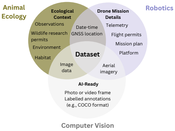
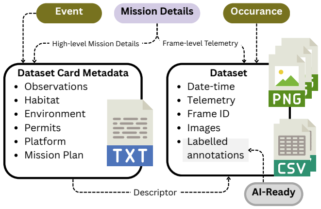
The FAIR^2 Drones standard bridges ecology, robotics, and computer vision by building on existing FAIR and AI-ready data frameworks while adding essential platform metadata and annotation specifications. Our standard enables datasets to simultaneously support ecological analysis, robotics algorithm development, and computer vision benchmarking. We provide open-source validation tools, reference implementations, and multimodal extensions linking drone imagery with complementary sensors such as camera traps, GPS, and acoustics. By standardizing metadata across disciplines, this framework maximizes the scientific return on investment for costly field deployments and accelerates cross-domain col
What carries the argument
The FAIR^2 Drones standard, which adds platform metadata and annotation specifications to existing data frameworks to enable simultaneous use by ecologists, roboticists, and computer vision researchers.
If this is right
- One field deployment can produce data that serves ecological studies, robotics testing, and computer vision benchmarks without separate collection campaigns.
- The return on investment for expensive drone operations rises because the same raw data supports multiple research uses.
- Cross-domain collaboration increases because standardized metadata removes the need to reformat or recollect data for each field.
- Multimodal datasets become easier to assemble and share when drone imagery is routinely linked to camera traps, GPS tracks, and acoustic recordings.
Where Pith is reading between the lines
- Legacy drone datasets could be retrofitted to the standard to measure how much extra annotation effort is actually required for full cross-domain compatibility.
- The same metadata approach might be adapted to other expensive sensor platforms such as satellite or underwater vehicles to reduce data silos in environmental science.
- Widespread adoption could support larger combined datasets that improve the training of AI models for species detection across varied habitats.
- Conservation projects might reduce duplicate drone flights by checking whether existing standardized datasets already cover their monitoring needs.
Load-bearing premise
Extending existing data frameworks with platform metadata and annotation specifications will be sufficient to bridge ecology, robotics, and computer vision without additional domain-specific barriers or adoption hurdles.
What would settle it
A concrete test in which teams from each of the three domains attempt to use a dataset formatted to the standard and at least one team finds the data insufficient for their required analysis, algorithm testing, or benchmarking.
Figures
read the original abstract
Animal ecology data collection using drones represents a substantial investment of time, expertise, and financial resources. Yet most existing datasets serve only a single research community, limiting interdisciplinary reuse. We propose a unified drone dataset standard, FAIR^2 Drones, that bridges ecology, robotics, and computer vision by building on existing FAIR and AI-ready data frameworks while adding essential platform metadata and annotation specifications. Our standard enables datasets to simultaneously support ecological analysis, robotics algorithm development, and computer vision benchmarking. We provide open-source validation tools, reference implementations, and multimodal extensions linking drone imagery with complementary sensors such as camera traps, GPS, and acoustics. By standardizing metadata across disciplines, this framework maximizes the scientific return on investment for costly field deployments and accelerates cross-domain collaboration in environmental monitoring.
Editorial analysis
A structured set of objections, weighed in public.
Referee Report
Summary. The manuscript proposes FAIR² Drones, a unified standard for wildlife drone datasets that extends existing FAIR and AI-ready frameworks by incorporating platform metadata and annotation specifications. This design is intended to enable the same datasets to support ecological analysis, robotics algorithm development, and computer vision benchmarking simultaneously. The work supplies open-source validation tools, reference implementations, and multimodal extensions linking drone imagery to sensors such as camera traps, GPS, and acoustics.
Significance. If adopted, the standard could increase the scientific return on costly drone deployments by facilitating cross-domain reuse. The provision of open-source validation tools and reference implementations is a concrete strength that renders the design testable rather than purely declarative.
major comments (1)
- [Abstract] Abstract: the claim that adding platform metadata and annotation specifications will suffice to bridge ecology, robotics, and computer vision is presented as a design assertion without a worked example dataset, interoperability test, or comparison against existing standards (e.g., existing wildlife drone schemas). This is load-bearing for the central sufficiency argument.
minor comments (2)
- The manuscript would benefit from an explicit schema table or JSON example in the main text (rather than only in the reference implementation) so readers can evaluate the added metadata fields without consulting external code.
- Clarify in the introduction whether the standard imposes any new constraints on existing FAIR or AI-ready metadata that could create adoption friction.
Simulated Author's Rebuttal
We thank the referee for the constructive review and recommendation of minor revision. The single major comment concerns the abstract's presentation of the central claim. We address it directly below.
read point-by-point responses
-
Referee: [Abstract] Abstract: the claim that adding platform metadata and annotation specifications will suffice to bridge ecology, robotics, and computer vision is presented as a design assertion without a worked example dataset, interoperability test, or comparison against existing standards (e.g., existing wildlife drone schemas). This is load-bearing for the central sufficiency argument.
Authors: The manuscript supplies reference implementations, open-source validation tools, and multimodal extensions as concrete demonstrations that the added metadata and annotations enable cross-domain use. These artifacts function as worked examples of interoperability and are described in the body of the paper, including explicit comparisons to prior wildlife-drone schemas in the related-work section. We agree, however, that the abstract itself presents the sufficiency claim without referencing these elements. We will therefore revise the abstract to include a concise clause noting the availability of the validation tools and reference implementations as supporting evidence. revision: yes
Circularity Check
No significant circularity; proposal is a design specification
full rationale
The manuscript is a forward-looking data standard proposal that extends existing FAIR and AI-ready frameworks with platform metadata and annotation rules. It contains no equations, fitted parameters, predictions, or derivation chains. The central claim is a design assertion made testable via supplied open-source validation tools and reference implementations. No self-citation is load-bearing, no ansatz is smuggled, and no result reduces to its inputs by construction. This is the expected non-finding for a standards paper.
Axiom & Free-Parameter Ledger
axioms (1)
- domain assumption Existing FAIR and AI-ready data frameworks can be extended with platform metadata and annotation specifications to support multiple domains simultaneously.
invented entities (1)
-
FAIR^2 Drones standard
no independent evidence
Reference graph
Works this paper leans on
-
[1]
Hughey, L. F., Hein, A. M., Strandburg-Peshkin, A. & Jensen, F. H. Challenges and solutions for studying collective animal behaviour in the wild.Philos. Transactions Royal Soc. B: Biol. Sci.373, 20170005, DOI: 10.1098/rstb.2017.0005 (2018)
-
[2]
Maalouf, G.et al.Insights into safe and scalable bvlos uas operations from kenya’s oi pejeta conservancy. In2025 International Conference on Unmanned Aircraft Systems (ICUAS), 905–912, DOI: 10.1109/ICUAS65942.2025.11007907 (2025)
-
[3]
Lundquist, U. P. S.et al.Wilddrone: autonomous drone technology for monitoring wildlife populations.Front. Robotics AI12, DOI: 10.3389/frobt.2025.1695319 (2026). 6.Afridi, S.et al.Impact of drone disturbances on wildlife: A review.Drones9, 311 (2025)
-
[4]
Kline, J.et al.Wildwing: An open-source, autonomous and affordable uas for animal behaviour video monitoring.Methods Ecol. Evol. (2025)
2025
-
[5]
Corcoran, E., Winsen, M., Sudholz, A. & Hamilton, G. Automated detection of wildlife using drones: Synthesis, opportunities and constraints.Methods Ecol. Evol.12, 1103–1114, DOI: 10.1111/2041-210X.13581 (2021)
-
[6]
Schad, L. & Fischer, J. Opportunities and risks in the use of drones for studying animal behaviour.Methods Ecol. Evol.14, 1864–1872, DOI: 10.1111/2041-210X.13922 (2023). 10.Iglay, R. B.et al.Wildlife monitoring with drones: A survey of end users.Wildl. Soc. Bull.48, e1533, DOI: 10.1002/wsb.1533 (2024)
-
[7]
Commun.13, 792, DOI: 10.1038/s41467-022-27980-y (2022)
Tuia, D.et al.Perspectives in machine learning for wildlife conservation.Nat. Commun.13, 792, DOI: 10.1038/s41467-022-27980-y (2022). 12.Desai, B.et al.Identification of free-ranging mugger crocodiles by applying deep learning methods on uav imagery.Ecol. Informatics 72, 101874 (2022)
-
[8]
Ozogány, K., Kerekes, V ., Fülöp, A., Barta, Z. & Nagy, M. Fine-scale collective movements reveal present, past and future dynamics of a multilevel society in przewalski’s horses.Nat. Commun.14, 5096, DOI: 10.1038/s41467-023-40523-3 (2023). 14.Kline, J.et al.kabr-tools: Automated framework for multi-species behavioral monitoring.arXiv preprint arXiv:2510....
-
[9]
F.et al.A standardized protocol for reporting methods when using drones for wildlife research.J
Barnas, A. F.et al.A standardized protocol for reporting methods when using drones for wildlife research.J. Unmanned Veh. Syst.8, 89–98, DOI: 10.1139/juvs-2019-0011 (2020)
-
[10]
Ellsäßer, F. J. & Nikuze, A. Towards a FAIR metadata framework for drone and uncrewed aerial vehicle data.Sci. Data13, 57, DOI: 10.1038/s41597-025-06376-9 (2025). 17.Wieczorek, J.et al.Darwin core: an evolving community-developed biodiversity data standard.PloS one7, e29715 (2012). 10/12
-
[11]
Guralnick, R., Walls, R. & Jetz, W. Humboldt core – toward a standardized capture of biological inventories for biodiversity monitoring, modeling and assessment.Ecography41, 713–725, DOI: 10.1111/ecog.02942 (2018). 19.Akhtar, M.et al.Croissant: A metadata format for ml-ready datasets.Adv. Neural Inf. Process. Syst.37, 82133–82148 (2024). 20.Gebru, T.et al...
-
[12]
Yang, X., Liang, W. & Zou, J. Navigating dataset documentations in ai: A large-scale analysis of dataset cards on hugging face.arXiv preprint arXiv:2401.13822(2024). 22.Jenkins, G. B.et al.Reproducibility in ecology and evolution: Minimum standards for data and code.Ecol. Evol.13, e9961 (2023)
arXiv 2024
-
[13]
Scientific Data3(1), 1–9 (2016), https://doi.org/10.1038/sdata.2016.18
Wilkinson, M. D.et al.The fair guiding principles for scientific data management and stewardship.Sci. Data3, 160018, DOI: 10.1038/sdata.2016.18 (2016)
-
[14]
A.et al.Fair for ai: An interdisciplinary and international community building perspective.Sci
Huerta, E. A.et al.Fair for ai: An interdisciplinary and international community building perspective.Sci. Data10, 487, DOI: 10.1038/s41597-023-02298-6 (2023). 25.Biodiversity information standards (tdwg)
-
[15]
Naik, H.et al.Bucktales: A multi-uav dataset for multi-object tracking and re-identification of wild antelopes.Adv. Neural Inf. Process. Syst.37, 81992–82009 (2024). 27.Kline, J.et al.Mmla: Multi-environment, multi-species, low-altitude aerial footage dataset.arXiv preprint arXiv:2504.07744(2025)
arXiv 2024
-
[16]
Animal Ecol.92, 1357–1371, DOI: 10.1111/1365-2656.13904 (2023)
Koger, B.et al.Quantifying the movement, behaviour and environmental context of group-living animals using drones and computer vision.J. Animal Ecol.92, 1357–1371, DOI: 10.1111/1365-2656.13904 (2023)
-
[17]
Mou, C., Liu, T., Zhu, C. & Cui, X. Waid: A large-scale dataset for wildlife detection with drones.Appl. Sci.13, 10397, DOI: 10.3390/app131810397 (2023)
-
[18]
Cai, L., McGuire, N. E., Hanlon, R., Mooney, T. A. & Girdhar, Y . Semi-supervised visual tracking of marine animals using autonomous underwater vehicles.Int. J. Comput. Vis.131, 1406–1427, DOI: 10.1007/s11263-023-01762-5 (2023). 31.Humboldt extension. https://www.tdwg.org/community/osr/humboldt-extension/
-
[19]
Motion Imagery Standards Board (MISB) Website
Motion Imagery Standards Board (MISB). Motion Imagery Standards Board (MISB) Website. https://gwg.nga.mil/gwg/focus-groups/ Motion_Imagery_Standards_Board_(MISB).html (2026). Accessed: 2026-01-14. 33.Koubâa, A.et al.Micro air vehicle link (mavlink) in a nutshell: A survey.IEEE Access7, 87658–87680 (2019). 34.Airdata. Drone data management and flight analy...
2026
-
[20]
Stevens, S., Rayeed, S. & Kline, J. Mind the gap: Evaluating vision systems in small data applications.arXiv preprint arXiv:2504.06486 (2025). 36.CV AT.ai Corporation. Computer vision annotation tool (cvat), DOI: 10.5281/zenodo.4009388 (2023). 37.Hugging Face. Datasets documentation: Dataset cards. https://huggingface.co/docs/hub/datasets-cards (2022). Ac...
-
[21]
Pushkarna, M., Zaldivar, A. & Kjartansson, O. Data cards: Purposeful and transparent dataset documentation for responsible ai. In Proceedings of the 2022 ACM Conference on Fairness, Accountability, and Transparency, 1776–1826, DOI: 10.1145/3531146.3533231 (2022)
-
[22]
Meier, K.et al.Simulated and Field-Based Error Characterisation of Animal Geolocalisation and Relative Positioning via Commercial Drones, DOI: 10.6084/m9.figshare.30206908.v1 (2025). 40.Campolongo, E. G.et al.Collaborative distributed science guide, DOI: 10.5281/zenodo.17210328 (2025). GitHub release v1.3.0. 41.Campolongo, E. G.et al.Imageomics Guide, DOI...
-
[23]
InProceedings of the Computer Vision and Pattern Recognition Conference, 13854–13864 (2025)
Gabeff, V .et al.Mammalps: A multi-view video behavior monitoring dataset of wild mammals in the swiss alps. InProceedings of the Computer Vision and Pattern Recognition Conference, 13854–13864 (2025)
2025
-
[24]
Evol.13, 419–431, DOI: 10.1111/2041-210X.13767 (2022)
Kays, R.et al.The movebank system for studying global animal movement and demography.Methods Ecol. Evol.13, 419–431, DOI: 10.1111/2041-210X.13767 (2022). 11/12 45.Besson, M.et al.Towards the fully automated monitoring of ecological communities.Ecol. letters25, 2753–2775 (2022)
-
[25]
https://github.com/neuroinformatics-unit/movement, DOI: 10.5281/zenodo.12755724 (2024)
Sirmpilatze, N.et al.movement. https://github.com/neuroinformatics-unit/movement, DOI: 10.5281/zenodo.12755724 (2024). Python tools for analysing body movements across space and time
-
[26]
G.et al.Drone swarms for multi-perspective monitoring
Rolland, E. G.et al.Drone swarms for multi-perspective monitoring. InAdvances in Practical Applications of Agents, Multi-Agent Systems, and Computational Social Science: The PAAMS Collection: 23rd International Conference, PAAMS 2025, Lille, France, June 25–27, 2025, Proceedings, 266–277 (Springer Nature, 2025). 12/12
2025
discussion (0)
Sign in with ORCID, Apple, or X to comment. Anyone can read and Pith papers without signing in.