Spatial Support Matters: Geometry-Aware Graph Fusion for Rainfall Field Reconstruction
Pith reviewed 2026-07-03 14:44 UTC · model grok-4.3
The pith
Representing rainfall measurements by their spatial support type in a heterogeneous graph neural network improves reconstruction accuracy over methods that ignore geometry.
A machine-rendered reading of the paper's core claim, the machinery that carries it, and where it could break.
Core claim
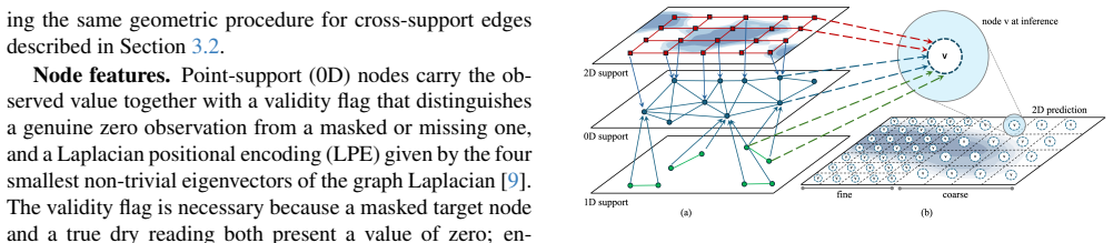
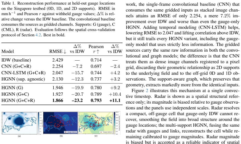
The authors propose a geometry-aware multi-support heterogeneous graph neural network that assigns each observation to a distinct node layer based on whether it is a 0D point, 1D line, or 2D grid, then fuses information across these layers via message passing to produce predictions at point support for field reconstruction. This approach outperforms classical interpolation and other neural methods on Singapore rainfall data, with a 23.2% RMSE reduction over inverse-distance weighting, and shows that gains depend on gauge spacing relative to the correlation length of the rainfall field.
What carries the argument
The geometry-aware multi-support heterogeneous graph with cross-support message passing into a point-support prediction layer.
If this is right
- The proposed model reduces RMSE by 23.2% compared to inverse-distance weighting on Singapore data.
- It consistently outperforms convolutional fusion and support-agnostic heterogeneous graph baselines.
- Multi-support fusion provides the largest gains when the rainfall field is under-sampled relative to its correlation length.
- The inductive formulation enables reconstruction at arbitrary user-defined target locations without retraining.
Where Pith is reading between the lines
- This approach could extend to other domains with mixed sensor supports, such as combining point samples and satellite grids for temperature or pollution mapping.
- The finding that performance depends on sampling density versus correlation length suggests prioritizing multi-support fusion in regions with sparse gauges.
- Testing the model on datasets with additional support types, like volumetric measurements, would clarify its scalability.
Load-bearing premise
That treating different measurement supports as distinct node layers and fusing them with cross-support message passing captures the geometrically distinct constraints each type imposes on the rainfall field.
What would settle it
A head-to-head comparison on the Singapore dataset where a support-agnostic graph neural network achieves equal or lower RMSE than the geometry-aware version would indicate that modeling support geometry is not necessary for the performance gains.
Figures
read the original abstract
Fine-scale rainfall reconstruction is critical for urban flood modeling, but real rainfall sensing systems observe the field through incompatible spatial supports: gauges measure points, microwave links measure paths, and radar/satellite products measure gridded areas. These differences in measurement support impose geometrically distinct constraints on the rainfall field, yet existing heterogeneous graph approaches reconcile such sources in feature space, giving each its own embedding while discarding the geometry of its support. We propose a geometry-aware multi-support heterogeneous graph neural network that represents each observation according to its support type (0D point, 1D line, or 2D grid) as a distinct node layer, and fuses them through cross-support message passing into a point-support prediction layer from which the field is reconstructed. An inductive masked-node formulation decouples prediction resolution from sensing resolution, allowing the same trained model to reconstruct the field at user-defined target locations or display grids. On Singapore data, the proposed method reduces RMSE by 23.2\% over the classical interpolation baseline, inverse-distance weighting, and consistently outperforms other neural architectures such as convolutional fusion and support-agnostic heterogeneous graph baselines. A generalization study using data from Sydney, Australia lets us characterize when multi-support fusion helps: the available skill appears to depend on gauge spacing relative to the spatial correlation length of the field, so fusion delivers the largest gains where the field is under-sampled relative to its correlation length and little when it is already resolved. Code and models will be open-sourced upon paper acceptance.
Editorial analysis
A structured set of objections, weighed in public.
Referee Report
Summary. The paper proposes a geometry-aware multi-support heterogeneous graph neural network for fine-scale rainfall field reconstruction. Observations from gauges (0D points), microwave links (1D lines), and radar (2D grids) are represented as distinct node layers; these are fused via cross-support message passing into a point-support prediction layer. An inductive masked-node formulation decouples prediction from sensing resolution. On Singapore data the method reports a 23.2% RMSE reduction versus inverse-distance weighting and outperforms convolutional and support-agnostic heterogeneous baselines; a Sydney generalization study links gains to gauge spacing relative to field correlation length. Code will be released upon acceptance.
Significance. If the reported gains are shown to arise from explicit incorporation of support geometry rather than multi-source fusion alone, the work would provide a practical advance for urban hydrology and multi-modal spatial reconstruction. The inductive formulation and the analysis tying fusion benefit to sampling density versus correlation length are useful contributions; open-sourcing of code strengthens reproducibility.
major comments (1)
- [Abstract and §3] Abstract and §3 (model description): the central claim that distinct node layers plus cross-support message passing 'capture geometrically distinct constraints' requires explicit confirmation that message functions or edge attributes contain support-specific geometric operators (path integration for 1D links, areal averaging for 2D grids, support-specific kernels). If the implementation uses only centroid distances and type embeddings, the architecture reduces to a heterogeneous GNN with labels; the 23.2% RMSE gain could then be explained by multi-source fusion alone, weakening the geometry-awareness emphasis.
minor comments (2)
- [Experiments] Experiments section: report error bars, data-split details, and ablation studies isolating the contribution of cross-support geometry operators versus simple type-aware fusion.
- [Figures/Tables] Figure captions and tables: ensure all baselines (including support-agnostic heterogeneous GNN) are described with identical hyper-parameter budgets and training protocols.
Simulated Author's Rebuttal
We thank the referee for the constructive comment on clarifying the geometry-awareness claim. We address the point below and will revise the manuscript accordingly.
read point-by-point responses
-
Referee: [Abstract and §3] Abstract and §3 (model description): the central claim that distinct node layers plus cross-support message passing 'capture geometrically distinct constraints' requires explicit confirmation that message functions or edge attributes contain support-specific geometric operators (path integration for 1D links, areal averaging for 2D grids, support-specific kernels). If the implementation uses only centroid distances and type embeddings, the architecture reduces to a heterogeneous GNN with labels; the 23.2% RMSE gain could then be explained by multi-source fusion alone, weakening the geometry-awareness emphasis.
Authors: We agree that the current description in §3 does not sufficiently detail the support-specific operators. The model does incorporate them: for 1D microwave-link nodes, message functions include explicit path integration along the link geometry (using the known endpoint coordinates and length to aggregate rainfall along the 1D support); for 2D radar-grid nodes, areal averaging is performed over the grid cell area via support-specific kernels that weight contributions by intersection with the target point; point-gauge nodes use standard distance kernels. These operators are encoded in the edge attributes and message functions of the cross-support layers, beyond mere type embeddings and centroid distances. We will expand §3 with pseudocode and equations making these operators explicit, and add a short ablation confirming that removing the geometric operators reduces performance to levels comparable with support-agnostic heterogeneous baselines. revision: yes
Circularity Check
No significant circularity; empirical architecture evaluated on external data
full rationale
The paper proposes a heterogeneous GNN architecture for multi-support rainfall reconstruction and reports empirical RMSE improvements on Singapore and Sydney datasets against baselines. No equations or derivations are presented that reduce by construction to fitted inputs or self-citations. The central claim rests on experimental comparisons rather than a closed mathematical chain. The work is self-contained against external benchmarks with no load-bearing self-citation or self-definitional steps visible in the abstract or description.
Axiom & Free-Parameter Ledger
Reference graph
Works this paper leans on
-
[1]
DUALFloodGNN: Physics-informed Graph Neural Network for Operational Flood Modeling
Carlo Malapad Acosta, Herath Mudiyanselage Viraj Vidura Herath, Jia Yu Lim, Abhishek Saha, Sanka Rasnayaka, and Lucy Amanda Marshall. Physics-informed graph neural networks for operational flood modeling.ArXiv, abs/2512.23964, 2025. 1
work page internal anchor Pith review Pith/arXiv arXiv 2025
-
[2]
Rf-mep: A novel random forest method for merging gridded precipitation products and ground-based measurements.Remote Sensing of Environment, 239, 2020
Oscar Baez-Villanueva, Mauricio Zambrano-Bigiarini, Hylke Beck, Ian McNamara, Lars Ribbe, Alexandra Nauditt, Christian Birkel, Koen Verbist, Juan Diego Giraldo- Osorio, and Nguyen Thinh. Rf-mep: A novel random forest method for merging gridded precipitation products and ground-based measurements.Remote Sensing of Environment, 239, 2020. 2
2020
-
[3]
A variational approach to retrieve rain rate by combining information from rain gauges, radars, and microwave links.Journal of Hydrometeorology, 14:1897– 1909, 2013
Blandine Bianchi, Peter Jan Van Leeuwen, Robin Hogan, and Alexis Berne. A variational approach to retrieve rain rate by combining information from rain gauges, radars, and microwave links.Journal of Hydrometeorology, 14:1897– 1909, 2013. 2
1909
-
[4]
WaterData: Water data online
Bureau of Meteorology. WaterData: Water data online. http://www.bom.gov.au/waterdata/. Retrieved February 2026. 6
2026
-
[5]
AURA – operational radar Rain- fields 3, 2022
Bureau of Meteorology. AURA – operational radar Rain- fields 3, 2022. Accessed via NCI project rq0. 6
2022
-
[6]
Himawari 8/9 convective rain rate – physically based (CRRPH), 2024
Bureau of Meteorology. Himawari 8/9 convective rain rate – physically based (CRRPH), 2024. Accessed via NCI project rv74. 6
2024
-
[7]
Mul- tisource precipitation data fusion: Generating high-quality precipitation estimates.The Innovation Geoscience, 4: 100195, 2026
Hanqing Chen, Jiangyuan Zeng, Yi Lyu, and Bin Yong. Mul- tisource precipitation data fusion: Generating high-quality precipitation estimates.The Innovation Geoscience, 4: 100195, 2026. 2
2026
-
[8]
Commercial mi- crowave link networks for rainfall observation: Assessment of the current status and future challenges.Wiley Interdisci- plinary Reviews: Water, 6, 2019
Christian Chwala and Harald Kunstmann. Commercial mi- crowave link networks for rainfall observation: Assessment of the current status and future challenges.Wiley Interdisci- plinary Reviews: Water, 6, 2019. 3
2019
-
[9]
A generalization of transformer networks to graphs.CoRR, abs/2012.09699,
Vijay Prakash Dwivedi and Xavier Bresson. A generalization of transformer networks to graphs.CoRR, abs/2012.09699,
-
[10]
Fast Graph Representation Learning with PyTorch Geometric
Matthias Fey and Jan Eric Lenssen. Fast graph representation learning with pytorch geometric.CoRR, abs/1903.02428,
work page internal anchor Pith review Pith/arXiv arXiv 1903
-
[11]
Geostatistical approaches for incorporat- ing elevation into the spatial interpolation of rainfall.Journal of Hydrology, 228:113–129, 2000
Pierre Goovaerts. Geostatistical approaches for incorporat- ing elevation into the spatial interpolation of rainfall.Journal of Hydrology, 228:113–129, 2000. 1, 6
2000
-
[12]
Learning skillful medium-range global weather forecasting.Science (New York, N.Y.), 382: eadi2336, 2023
Remi Lam, Alvaro Sanchez-Gonzalez, Matthew Willson, Peter Wirnsberger, Meire Fortunato, Ferran Alet, Suman Ravuri, Timo Ewalds, Zach Eaton-Rosen, Weihua Hu, Alexander Merose, Stephan Hoyer, George Holland, Oriol Vinyals, Jacklynn Stott, Alexander Pritzel, Shakir Mo- hamed, and Peter Battaglia. Learning skillful medium-range global weather forecasting.Scie...
2023
-
[13]
Learning to reconstruct missing data from spatiotemporal graphs with sparse observations, 2022
Ivan Marisca, Andrea Cini, and Cesare Alippi. Learning to reconstruct missing data from spatiotemporal graphs with sparse observations, 2022. 4, 5
2022
-
[14]
A deep learning multimodal method for precipi- tation estimation.Remote Sensing, 13:3278, 2021
Arthur Moraux, Steven Dewitte, Bruno Cornelis, and Adrian Munteanu. A deep learning multimodal method for precipi- tation estimation.Remote Sensing, 13:3278, 2021. 1, 2
2021
-
[15]
Rainfall across Singapore
National Environment Agency. Rainfall across Singapore. data.gov.sg, Dataset, 2024. Retrieved April 8, 2026. 6
2024
-
[16]
A review of radar-rain gauge data merg- ing methods and their potential for urban hydrological appli- cations.Water Resources Research, 55, 2019
Susana Ochoa-Rodriguez, Li-Pen Wang, Patrick Willems, and Christian Onof. A review of radar-rain gauge data merg- ing methods and their potential for urban hydrological appli- cations.Water Resources Research, 55, 2019. 1, 2, 6, 7
2019
-
[17]
Overeem, H
A. Overeem, H. Leijnse, and Remko Uijlenhoet. Retrieval algorithm for rainfall mapping from microwave links in a cellular communication network.Atmospheric Measurement Techniques Discussions, 8:8191–8230, 2015. 3
2015
-
[18]
Cngat: A graph neu- ral network model for radar quantitative precipitation estima- tion.IEEE Transactions on Geoscience and Remote Sensing, PP:1–1, 2021
Xuan Peng, Qian Li, and Jinrui Jing. Cngat: A graph neu- ral network model for radar quantitative precipitation estima- tion.IEEE Transactions on Geoscience and Remote Sensing, PP:1–1, 2021. 1, 2
2021
-
[19]
Pluvia – commercial microwave link and radar data
Pluvia.ai. Pluvia – commercial microwave link and radar data. CML and gauge-corrected radar data for Singapore, provided via research collaboration, 2025. 6
2025
-
[20]
Xiao Wang, Deyu Bo, Chuan Shi, Shaohua Fan, Yanfang Ye, and Philip S. Yu. A survey on heterogeneous graph embed- ding: Methods, techniques, applications and sources.IEEE Transactions on Big Data, 9:415–436, 2020. 1, 2
2020
-
[21]
A spatiotemporal deep fusion model for merging satellite and gauge precipitation in china.Journal of Hydrology, 584: 124664, 2020
Hongcai Wu, Qinli Yang, Jiaming Liu, and Guoqing Wang. A spatiotemporal deep fusion model for merging satellite and gauge precipitation in china.Journal of Hydrology, 584: 124664, 2020. 1, 6
2020
-
[22]
Inductive graph neural networks for spatiotemporal kriging,
Yuankai Wu, Dingyi Zhuang, Aurelie Labbe, and Lijun Sun. Inductive graph neural networks for spatiotemporal kriging,
-
[23]
Local off-grid weather forecasting with multi-modal earth observation data.Journal of Advances in Modeling Earth Systems, 17(12):e2025MS005207, 2025
Qidong Yang, Jonathan Giezendanner, Daniel Salles Civ- itarese, Johannes Jakubik, Eric Schmitt, Anirban Chandra, Jeremy Vila, Detlef Hohl, Chris Hill, Campbell Watson, and Sherrie Wang. Local off-grid weather forecasting with multi-modal earth observation data.Journal of Advances in Modeling Earth Systems, 17(12):e2025MS005207, 2025. e2025MS005207 2025MS0...
2025
discussion (0)
Sign in with ORCID, Apple, or X to comment. Anyone can read and Pith papers without signing in.