REVIEW 4 major objections 7 minor 33 references
RoadWeaver: Large-Scale Lane-Level HD Map Generation from Scratch for Autonomous Driving Simulation
T0 review · 4 major / 7 minor · reviewed 2026-08-16 · deepseek-v4-flash
Pith's one-line read RoadWeaver generates complete, large-scale, lane-level HD maps from scratch for autonomous-driving simulation, reporting 99.8% reachability, 0.24 m endpoint alignment, and direct import into a driving simulator.
desk verdict RoadWeaver is a solid system integration for from-scratch HD map generation with practical deployability, but its headline metrics are largely by-construction and 'simulation-ready' is only shown via import and routing. read the letter →
The pith
A machine-rendered reading of the paper's core claim, the machinery that carries it, and where it could break.
The reading
What carries the argument
The central machinery is the road-field tensor $F \in \mathbb{R}^{H \times W \times 6}$, a six-channel raster carrying road probability, two orientation channels, junction and endpoint heatmaps, and a distance field, which lets a road graph be treated as an image-like field. A VQ-VAE compresses this tensor into discrete latent tokens, and a conditional masked Transformer, conditioned on an 11-dimensional vector of road-style and structural priors such as density, gridness, radialness, organicness, and bearing entropy, samples globally coherent skeletons. Expansion relies on the structure tensor $T(p)$ built from tangent samples along the skeleton; its eigenvectors steer a procedural road-growth front with style-dependent perturbation, and A* search over the predicted road evidence reconnects dangling ends. The lane-construction stage converts the refined graph into directed lanes and junction connectors, then runs geometry and topology repair passes, so the final map carries consistent predecessor, successor, and neighbour links.
What would settle it
Take a fixed rule-based lane-following and speed controller, run the same set of routes on 100 RoadWeaver maps and on 100 manually designed maps of comparable complexity, and count task completion, collisions, and off-road events. If completion collapses or collision rates are far higher on the generated maps, the claim that the maps are directly deployable for closed-loop evaluation fails.
Extended reading notes
Core claim
RoadWeaver's central claim is that from-scratch lane-level HD map generation can be decomposed into three stages that are individually tractable and jointly sufficient: sample a sparse global road skeleton from a learned discrete representation, expand it into a connected road graph by tensor-guided procedural growth, and convert that graph into a lane-level map with explicit topology-repair passes. The paper reports that this produces a directed lane graph with predecessor, successor, and neighbour relationships, a largest-connected-component ratio of 99.9%, reachability of 99.8%, a dead-end ratio of 10.7%, a cycle ratio of 85.2%, and a 0.24 m average distance between lane endpoints that should meet. It further reports that 100 generated maps all import into a driving simulator and that 987 of 1,000 route-planning tasks succeed, with full-map generation in 1.39–3.50 s. These numbers are offered as evidence that the pipeline closes the gap between generative map synthesis and practical closed-loop evaluation.
Load-bearing premise
The load-bearing premise is that a map that scores well on the paper's own connectivity and alignment metrics, and that supports route planning in one simulator, will also support full closed-loop autonomous driving — the paper does not run any vehicle-level driving test.
Editorial extensions
If this is right
- Simulation suites can be scaled to hundreds of diverse networks by increasing map area at fixed road density, removing the need to handcraft each environment.
- A 0.24 m endpoint alignment error, compared with 4.32–8.17 m for the examined baselines, places generated lane geometry in the range where route planning in the tested simulator succeeds on 98.7% of tasks.
- Because maps are exported in standard road-map formats, the same generated network can be moved across simulator toolchains without manual conversion.
- Controllable road-node density gives evaluation designers a direct knob for sweeping map complexity while keeping connectivity and lane-level consistency.
Reading between the lines
- Because the paper's simulator test stops at route planning, a natural next experiment is a full closed-loop planner-controller evaluation; that experiment would show whether the 0.24 m endpoint alignment is sufficient for stable driving behavior.
- The skeleton model and the procedural expansion are separable components, so a reader could replace the learned skeleton prior with a different city's distribution while keeping the growth rules, directly testing how much of the output's quality comes from the learned prior rather than the procedural geometry.
- The endpoint-alignment error is measured on lane connections the pipeline itself computes and repairs; an independent audit measuring alignment on all near-miss lane endpoints before and after the repair pass would reveal whether the 0.24 m reflects raw generation quality or the repair step.
Signed reviews
Editorial analysis
A structured set of objections, weighed in public.
Referee Report
Summary. The paper proposes RoadWeaver, a coarse-to-fine framework for generating large-scale lane-level HD maps from scratch for autonomous driving simulation. The pipeline consists of three stages: global road skeleton generation using a VQ-VAE and a conditional masked Transformer; skeleton-guided road graph expansion via a structure tensor field and procedural growth with A*-based reconnection; and lane-level HD map construction through a sequence of graph refinement, lane assignment, junction connection, and geometric/topological repair operations (Algorithm 1). The authors report LCC of 99.9%, reachability of 99.8%, dead-end ratio of 10.7%, cycle ratio of 85.2%, endpoint alignment error of 0.24 m, generation time of 1.39--3.50 s, 100% import success in Tactics2D, and 98.7% route-planning success over 1,000 routing tasks. The central claim is that RoadWeaver is the first method to combine from-scratch generation, global topology, lane-level detail, large-scale output, controllability, and direct simulator deployability.
Significance. If the central claim is fully validated, RoadWeaver would be a useful contribution: it offers a single trainable pipeline that goes from a learned global layout to simulator-importable lane-level maps with explicit density control, potentially enabling scalable closed-loop evaluation of autonomous driving systems. The integration with Tactics2D and the explicit report of runtime, connectivity, and downstream routing success are strengths. However, the headline metrics are computed on outputs that have already been filtered and repaired by the method itself, and the only downstream validation is route planning; no closed-loop driving or traffic simulation is performed. Thus the significance of the results, especially the 'simulation-ready' claim, is currently supported only conditionally. The paper also ships no code at review time and omits many training and procedural hyperparameters, which limits reproducibility and makes the robustness of the reported numbers difficult to assess.
major comments (4)
- [Section IV-C / Table II / Algorithm 1] The headline topological and geometric metrics (LCC 99.9%, reachability 99.8%, dead-end 10.7%, endpoint alignment 0.24 m) are measured on road graphs that have already undergone A*-based reconnection of dangling endpoints, largest-connected-component filtering (Section III-C), and lane-level repair passes REPAIRLANEGEOMETRY and REPAIRTOPOLOGY in Algorithm 1. Consequently these metrics partly measure the method's own repair objective rather than the quality of the raw generated structure. To support the claim that RoadWeaver 'achieves' these numbers as a generation method, please report the same metrics before each repair/filtering stage, or provide an ablation that isolates the contribution of each repair step. Without this, the numbers in Table II are not an independent measure of generation quality.
- [Section IV-C / endpoint alignment error definition] The endpoint alignment error is defined as the average Euclidean distance between lane endpoints that are 'expected to be connected,' but the expected connections are generated by RoadWeaver's own ADDSUCCESSORLINKS step and then actively repaired by REPAIRLANEGEOMETRY and REPAIRTOPOLOGY. This makes the metric self-referential: the 0.24 m result is the residual after snapping or reconnecting endpoints that the method itself decided should be connected. Please define expected connections from an independent source (e.g., OSM ground truth, human annotations, or a separate verification process) or clearly state that this is a measure of internal consistency after repair, not of lane-level geometric fidelity.
- [Section IV-E] The claim that generated maps are 'directly deployable' and 'simulation-ready' rests on 100% import success (a format-compatibility check) and 98.7% route-planning success in Tactics2D. Import success shows that the file format is accepted, and routing success shows that a shortest path exists in the generated lane graph, but neither demonstrates that the maps support closed-loop driving, traffic simulation, or behavioral evaluation. Task completion, collision avoidance, and traffic-rule compliance are not tested. Please add at least one closed-loop driving or traffic-simulation experiment (e.g., a simple rule-based agent following a route in a generated map, with metrics such as route completion rate and collision rate), or explicitly restrict the claim to import and routing compatibility rather than full simulation readiness.
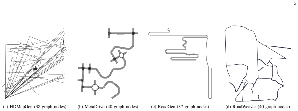
- [Section IV-C / Table II / baseline comparison] The comparison with MetaDrive, RoadGen, and HDMapGen in Table II is apples-to-oranges because the baselines are not given the equivalent repair, reconnection, and largest-connected-component filtering passes that RoadWeaver applies. The large differences in dead-end ratio and endpoint alignment error may therefore reflect the presence or absence of post-processing rather than inherent generation quality. Either apply the same repair pipeline to the baselines (if applicable) or report RoadWeaver's metrics without its repair stages, so that the comparison is fair.
minor comments (7)
- [Section III-B] Please report the VQ-VAE latent grid size, codebook size, transformer depth and width, training iterations, and conditioning encoding details; these are needed to reproduce the skeleton-generation stage.
- [Figure 1] The t-SNE visualization of driving behavior would benefit from a description of how trajectory features were extracted, which datasets were included, and how the color coding corresponds to scenario types; currently the figure is difficult to interpret.
- [Section IV-B / Figure 4] The density controllability demonstration shows measured densities close to targets, but there is no quantitative error metric or variance across seeds; consider reporting mean absolute error and standard deviation for density control.
- [Section IV-D] The statement that larger HDMapGen graphs 'provide limited quality improvement' is not quantified; either add a quantitative support or remove the claim.
- [Section IV-E] Please clarify how the 10 routing tasks per map were sampled (fixed seeds? random? endpoints chosen uniformly at random?) and report the variance of routing success across the 100 maps.
- [Table II] The metrics use different definitions of 'node' (intersections, endpoints, turning transition points); please state explicitly how each metric's node count is computed so that cross-method comparison is meaningful.
- [Section III-C] The free parameters sigma, w_tensor, w_inertia, theta_max, delta_s, the snapping radius, and the neighborhood radius are never given concrete values; listing them in a table would greatly aid reproducibility.
Circularity Check
The headline LCC, reachability, dead-end, and endpoint-alignment numbers are computed only after RoadWeaver's own reconnection, largest-connected-component filtering, and geometry/topology repair passes, so Table II largely reports the effect of the pipeline's repair objectives rather than an independent measure of generation quality.
-
other
[Section III-C (Skeleton-Guided Road Graph Expansion); Table II in Section IV-C]
"After procedural growth, dangling endpoints are reconnected to nearby roads through A* search [32] over a cost map derived from the decoded road field F. ... Residual disconnected fragments are subsequently removed through largest-connected-component filtering. ... RoadWeaver achieves an LCC of 99.9% and a reachability of 99.8% ... [and] obtains the lowest dead-end ratio among all compared methods."
The connectivity metrics that dominate the abstract and Section IV-C are measured on the graph after the pipeline has explicitly reconnected dangling endpoints with A* and removed all fragments outside the largest connected component. A high LCC and high reachability are therefore properties of the filtering/reconnection step itself, not discoveries about the generated road network. The dead-end ratio is likewise reduced by the same reconnection step before being reported. The metric is the objective of the post-processing, so the headline topological numbers are by construction to a substantial degree.
-
self definitional
[Section III-D, Algorithm 1, lines 11-14; Section IV-C, endpoint alignment error definition]
"L←ADDSUCCESSORLINKS(L) ... L←REPAIRLANEGEOMETRY(L) ... M←REPAIRTOPOLOGY(M) ... The endpoint alignment error is defined as the average Euclidean distance between lane endpoints that are expected to be connected [21, 22]."
The 'expected' connections used to define endpoint alignment error are the successor links added by RoadWeaver's own ADDSUCCESSORLINKS step, and the geometry/topology repair passes then snap or reconnect those very endpoints before the error is computed. In the detection baselines cited for this metric the expected connections come from ground-truth lane graphs; here there is no external ground truth, only the method's own linking and repair. The reported 0.24 m error is thus the residual of the repair objective, not an independent measure of lane-level generation fidelity, and the 94.4% improvement over baselines is apples-to-oranges because the baselines do not receive an equivalent repair pass.
full rationale
RoadWeaver's central pipeline is a legitimate coarse-to-fine generative system, and much of it is not circular: training a VQ-VAE and masked transformer on OSM-derived road fields, procedural expansion via a tensor field, and export to OSM/OpenDRIVE are independent, externally grounded steps. However, the two headline quantitative results in the abstract and Table II are measured after the method's own enforcement steps. Reachability, LCC, and dead-end ratio are computed after A*-based reconnection of dangling endpoints and largest-connected-component filtering, so high connectivity is largely the output of the post-processing rather than an independent property of the generated topology. The endpoint alignment error is defined relative to the lane connections that RoadWeaver itself creates with ADDSUCCESSORLINKS and then actively repairs with REPAIRLANEGEOMETRY and REPAIRTOPOLOGY, making the 0.24 m figure a by-construction residual of the repair pass. The only author self-citations ([1] and [19]) are not load-bearing here: the Tactics2D import and route-planning checks provide external, working-code evidence, and the generation-time and controllability experiments are independent. The paper's 'simulation-ready' claim is narrower than the rationale suggests because no closed-loop driving or traffic simulation is run, but that is a validity gap rather than a circularity. Overall, the central validity table is partially circular by construction, while the deployment and efficiency results retain independent content, so a score of 6 is appropriate.
Assumptions & free parameters
free parameters (7)
- Gaussian bandwidth sigma =
not reported
- w_tensor =
not reported
- w_inertia =
not reported
- theta_max =
not reported
- delta_s =
not reported
- snapping radius =
not reported
- latent grid size and codebook size =
not reported
assumptions (5)
- domain assumption The six-channel road-field tensor F preserves sufficient topology and geometry for the VQ-VAE and reconstruction to recover usable road skeletons.
- domain assumption The structure tensor of Eq. (1), built from skeleton tangents, provides a valid directional prior for procedural road growth.
- domain assumption OSM road graphs from 144 cities are a representative prior for diverse autonomous-driving maps.
- domain assumption The five metrics (LCC, reachability, dead-end, cycle ratio, endpoint alignment) are accepted proxies for HD map validity.
- domain assumption A* reconnection over the decoded road-field cost map produces topologically valid connections.
invented entities (1)
-
Road-field tensor F with six channels
Cite this review
Pith. "Pith review of RoadWeaver: Large-Scale Lane-Level HD Map Generation from Scratch for Autonomous Driving Simulation." pith.science (2026). https://pith.science/paper/LEX7Y3R6
@misc{pith2026260811580,
  author       = {Pith},
  title        = {Pith review of: RoadWeaver: Large-Scale Lane-Level HD Map Generation from Scratch for Autonomous Driving Simulation},
  year         = {2026},
  howpublished = {\url{https://pith.science/paper/LEX7Y3R6}},
  note         = {Machine review of arXiv:2608.11580}
}
read the original abstract
Autonomous driving simulation requires diverse and scalable lane-level HD maps to support long-horizon evaluation across complex road networks. Existing approaches either rely on handcrafted or reconstructed real-world maps, which limits scalability, or generate only local road structures rather than complete HD maps. We present RoadWeaver, a coarse-to-fine framework for from-scratch generation of diverse, large-scale HD maps. RoadWeaver first synthesizes a global road layout, expands it into a connected road network, and then constructs lane-level geometry with topologically consistent lane connectivity. Experimental results show that RoadWeaver achieves a 99.8\% reachability, a 10.7\% dead-end ratio, and an endpoint alignment error of 0.24 m. Compared with SOTA generation methods, it reduces endpoint alignment error by 94.4\% while generating complete HD maps in 1.39--3.50 s. The generated maps can be directly deployed in driving simulators, providing scalable simulation environments for future closed-loop evaluation of autonomous driving systems. The training code and an out-of-the-box implementation of RoadWeaver will be released upon acceptance.
Figures


Figures from the paper (3 more)


Reference graph
Works this paper leans on
-
[1]
Choose your simulator wisely: A review on open-source simulators for autonomous driving,
Y . Li, W. Yuan, S. Zhang, W. Yan, Q. Shen, C. Wang, and M. Yang, “Choose your simulator wisely: A review on open-source simulators for autonomous driving,”IEEE Transactions on Intelligent Vehicles, vol. 9, no. 5, pp. 4861–4876, 2024
2024
-
[2]
Carla: An open urban driving simulator,
A. Dosovitskiy, G. Ros, F. Codevilla, A. Lopez, and V . Koltun, “Carla: An open urban driving simulator,” in Conference on robot learning. PMLR, 2017, pp. 1–16
2017
-
[3]
Bench2drive: Towards multi-ability benchmarking of closed-loop end-to-end autonomous driving,
X. Jia, Z. Yang, Q. Li, Z. Zhang, and J. Yan, “Bench2drive: Towards multi-ability benchmarking of closed-loop end-to-end autonomous driving,”Advances in Neural Information Processing Systems, vol. 37, pp. 819–844, 2024
2024
-
[4]
A critical evaluation of the next generation simulation (ngsim) vehicle trajectory dataset,
B. Coifman and L. Li, “A critical evaluation of the next generation simulation (ngsim) vehicle trajectory dataset,” Transportation Research Part B: Methodological, vol. 105, pp. 362–377, 2017
2017
-
[5]
The highd dataset: A drone dataset of naturalistic vehicle trajectories on german highways for validation of highly automated driving systems,
R. Krajewski, J. Bock, L. Kloeker, and L. Eckstein, “The highd dataset: A drone dataset of naturalistic vehicle trajectories on german highways for validation of highly automated driving systems,” in2018 21st international conference on intelligent transportation systems (ITSC). IEEE, 2018, pp. 2118–2125
2018
-
[6]
The ind dataset: A drone dataset of natu- ralistic road user trajectories at german intersections,
J. Bock, R. Krajewski, T. Moers, S. Runde, L. Vater, and L. Eckstein, “The ind dataset: A drone dataset of natu- ralistic road user trajectories at german intersections,” in 2020 IEEE Intelligent Vehicles Symposium (IV). IEEE, 2020, pp. 1929–1934
work page 2020
-
[7]
The round dataset: A drone dataset of road user trajectories at roundabouts in germany,
R. Krajewski, T. Moers, J. Bock, L. Vater, and L. Eck- stein, “The round dataset: A drone dataset of road user trajectories at roundabouts in germany,” in2020 IEEE 23rd International Conference on Intelligent Transporta- tion Systems (ITSC). IEEE, 2020, pp. 1–6
work page 2020
-
[8]
Highly accurate scenario and reference data for automated driv- ing,
J. Bock, L. Vater, R. Krajewski, and T. Moers, “Highly accurate scenario and reference data for automated driv- ing,”ATZ worldwide, vol. 123, no. 5, pp. 50–55, 2021
work page 2021
Show all 33 references
-
[9]
Interaction dataset: An inter- national, adversarial and cooperative motion dataset in interactive driving scenarios with semantic maps,
W. Zhan, L. Sun, D. Wang, H. Shi, A. Clausse, M. Naumann, J. Kummerle, H. Konigshof, C. Stiller, A. de La Fortelleet al., “Interaction dataset: An inter- national, adversarial and cooperative motion dataset in interactive driving scenarios with semantic maps,”arXiv preprint ar...
1910 arXiv
-
[10]
nu- plan: A closed-loop ml-based planning benchmark for autonomous vehicles,
H. Caesar, J. Kabzan, K. S. Tan, W. K. Fong, E. Wolff, A. Lang, L. Fletcher, O. Beijbom, and S. Omari, “nu- plan: A closed-loop ml-based planning benchmark for autonomous vehicles,”arXiv preprint arXiv:2106.11810, 2021
2021 arXiv
-
[11]
Large scale interactive motion forecasting for autonomous driv- ing: The waymo open motion dataset,
S. Ettinger, S. Cheng, B. Caine, C. Liu, H. Zhao, S. Prad- han, Y . Chai, B. Sapp, C. R. Qi, Y . Zhouet al., “Large scale interactive motion forecasting for autonomous driv- ing: The waymo open motion dataset,” inProceedings of the IEEE/CVF International Conference on Computer...
2021
-
[12]
Parkpredict+: Multimodal intent and motion prediction for vehicles in parking lots with cnn and transformer,
X. Shen, M. Lacayo, N. Guggilla, and F. Borrelli, “Parkpredict+: Multimodal intent and motion prediction for vehicles in parking lots with cnn and transformer,” in 2022 IEEE 25th International Conference on Intelligent Transportation Systems (ITSC). IEEE, 2022, pp. 3999– 4004
2022
-
[13]
Citysim: A drone-based vehicle trajectory dataset for safety-oriented research and digital twins,
O. Zheng, M. Abdel-Aty, L. Yue, A. Abdelraouf, Z. Wang, and N. Mahmoud, “Citysim: A drone-based vehicle trajectory dataset for safety-oriented research and digital twins,”Transportation research record, vol. 2678, no. 4, pp. 606–621, 2024
2024
-
[14]
An environment for autonomous driving decision-making,
E. Leurent, “An environment for autonomous driving decision-making,” https://github.com/eleurent/highwa y-env, 2018, accessed Mar. 12, 2024
2018
-
[15]
Metadrive: Composing diverse driving scenarios for generalizable reinforcement learning,
Q. Li, Z. Peng, L. Feng, Q. Zhang, Z. Xue, and B. Zhou, “Metadrive: Composing diverse driving scenarios for generalizable reinforcement learning,”IEEE transactions on pattern analysis and machine intelligence, vol. 45, no. 3, pp. 3461–3475, 2022
2022
-
[16]
Hdmapgen: A hierarchical graph generative model of high definition maps,
L. Mi, H. Zhao, C. Nash, X. Jin, J. Gao, C. Sun, C. Schmid, N. Shavit, Y . Chai, and D. Anguelov, “Hdmapgen: A hierarchical graph generative model of high definition maps,” inProceedings of the IEEE/CVF Conference on Computer Vision and Pattern Recognition, 2021, pp. 4227–4236
2021
-
[17]
Openstreetmap: User- 8 generated street maps,
M. Haklay and P. Weber, “Openstreetmap: User- 8 generated street maps,”IEEE Pervasive computing, vol. 7, no. 4, pp. 12–18, 2008
2008
-
[18]
Opendrive 2010 and beyond–status and future of the de facto standard for the description of road networks,
M. Dupuis, M. Strobl, and H. Grezlikowski, “Opendrive 2010 and beyond–status and future of the de facto standard for the description of road networks,” inProc. of the Driving Simulation Conference Europe, 2010, pp. 231–242
2010
-
[19]
Tactics2d: A highly modular and extensible simulator for driving decision-making,
Y . Li, S. Zhang, M. Jiang, X. Chen, J. Yang, Y . Qian, C. Wang, and M. Yang, “Tactics2d: A highly modular and extensible simulator for driving decision-making,” IEEE Transactions on Intelligent Vehicles, vol. 9, no. 5, pp. 4840–4844, 2024
2024
-
[20]
Hdmapnet: An online hd map construction and evaluation framework,
Q. Li, Y . Wang, Y . Wang, and H. Zhao, “Hdmapnet: An online hd map construction and evaluation framework,” in2022 International Conference on Robotics and Au- tomation (ICRA). IEEE, 2022, pp. 4628–4634
2022
-
[21]
Maptr: Structured modeling and learn- ing for online vectorized hd map construction,
B. Liao, S. Chen, X. Wang, T. Cheng, Q. Zhang, W. Liu, and C. Huang, “Maptr: Structured modeling and learn- ing for online vectorized hd map construction,”arXiv preprint arXiv:2208.14437, 2022
2022 arXiv
-
[22]
Vec- tormapnet: End-to-end vectorized hd map learning,
Y . Liu, T. Yuan, Y . Wang, Y . Wang, and H. Zhao, “Vec- tormapnet: End-to-end vectorized hd map learning,” in International conference on machine learning. PMLR, 2023, pp. 22 352–22 369
2023
-
[23]
Road- gen: Generating road scenarios for autonomous vehicle testing,
F. Yang, Y . Lu, B. Chen, P. Qin, and X. Peng, “Road- gen: Generating road scenarios for autonomous vehicle testing,”arXiv preprint arXiv:2411.19577, 2024
2024 arXiv
-
[24]
Controlmap: Control- lable high-definition map generation for traffic scenario simulation,
M. Farag, S. W ¨aldele, and Y . Yao, “Controlmap: Control- lable high-definition map generation for traffic scenario simulation,”arXiv preprint arXiv:2606.15930, 2026
2026
-
[25]
Learning-based 3d reconstruction in autonomous driving: A comprehensive survey,
L. Liao, W. Yan, W. Xu, M. Yang, S. Zhang, and H. E. Tseng, “Learning-based 3d reconstruction in autonomous driving: A comprehensive survey,”IEEE Transactions on Intelligent Transportation Systems, 2025
2025
-
[26]
Neural discrete representation learning,
A. Van Den Oord, O. Vinyalset al., “Neural discrete representation learning,”Advances in neural information processing systems, vol. 30, 2017
2017
-
[27]
Taming trans- formers for high-resolution image synthesis,
P. Esser, R. Rombach, and B. Ommer, “Taming trans- formers for high-resolution image synthesis,” inProceed- ings of the IEEE/CVF conference on computer vision and pattern recognition, 2021, pp. 12 873–12 883
2021
-
[28]
Maskgit: Masked generative image transformer,
H. Chang, H. Zhang, L. Jiang, C. Liu, and W. T. Free- man, “Maskgit: Masked generative image transformer,” in2022 IEEE/CVF Conference on Computer Vision and Pattern Recognition (CVPR). IEEE, 2022, pp. 11 305– 11 315
2022
-
[29]
Scalable diffusion models with transformers,
W. Peebles and S. Xie, “Scalable diffusion models with transformers,” in2023 IEEE/CVF International Confer- ence on Computer Vision (ICCV). IEEE, 2023, pp. 4172–4182
2023
-
[30]
Procedural modeling of cities,
Y . I. Parish and P. M ¨uller, “Procedural modeling of cities,” inProceedings of the 28th annual conference on Computer graphics and interactive techniques, 2001, pp. 301–308
2001
-
[31]
Optimal orientation detection of linear symmetry,
J. Bigun and G. H. Granlund, “Optimal orientation detection of linear symmetry,” inProceedings of the IEEE First International Conference on Computer Vision, vol. 54. London, UK, 1987, pp. 433–438
1987
-
[32]
A formal basis for the heuristic determination of minimum cost paths,
P. E. Hart, N. J. Nilsson, and B. Raphael, “A formal basis for the heuristic determination of minimum cost paths,” IEEE transactions on Systems Science and Cybernetics, vol. 4, no. 2, pp. 100–107, 1968
1968
-
[33]
Osmnx: New methods for acquiring, con- structing, analyzing, and visualizing complex street net- works,
G. Boeing, “Osmnx: New methods for acquiring, con- structing, analyzing, and visualizing complex street net- works,”Computers, environment and urban systems, vol. 65, pp. 126–139, 2017
2017
Reviewed August 16, 2026 · model on record in the stance chip above.
Discussion (0). Continue with ORCID to comment.