Beyond Backscatter: AlphaEarth Land-Cover Priors for Rapid SAR Flood Segmentation Across Foundation Backbones
Pith reviewed 2026-06-30 08:09 UTC · model grok-4.3
The pith
AlphaEarth land-cover priors improve single-temporal SAR flood segmentation over SAR-only and DEM baselines across multiple foundation backbones.
A machine-rendered reading of the paper's core claim, the machinery that carries it, and where it could break.
Core claim
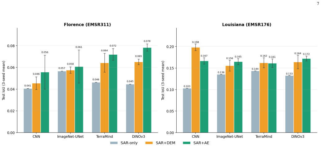
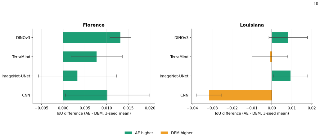
Both auxiliary priors improve over the observed SAR-only baselines across all backbones and test events. AlphaEarth exceeds DEM on the harder Florence event for every backbone and achieves the best Florence IoU, while DEM is competitive on Louisiana and produces the best result there. The seed analysis reveals a trade-off: DEM is more stable across initializations, whereas AlphaEarth offers higher peak performance and higher recall on the harder event. Cross-event differences track flood-class prevalence and similarity to the training distribution, underscoring the need for per-event evaluation.
What carries the argument
Fusion of single-temporal SAR imagery with registered, flood-independent land-cover priors from AlphaEarth (or DEM elevation) under an identical fusion design, training protocol, and backbones spanning CNN and Vision Transformer pretraining regimes.
If this is right
- Auxiliary priors raise accuracy on held-out events for every tested backbone.
- AlphaEarth delivers higher peak IoU and recall on harder events.
- DEM yields more stable results across random seeds.
- Performance gaps track how closely test floods match the training distribution in class prevalence.
- Per-event evaluation is required rather than aggregate metrics alone.
Where Pith is reading between the lines
- Land-cover priors could reduce reliance on pre-event SAR collections in operational monitoring systems.
- The alignment framing may apply to other SAR tasks that distinguish permanent surfaces from transient changes.
- Combining priors with foundation backbones could lower the volume of labeled flood data needed for training.
Load-bearing premise
The AlphaEarth land-cover priors are stable, accurate, and properly registered with the SAR imagery such that they provide flood-independent context without introducing alignment errors or biases in the fusion process.
What would settle it
A new flood event where adding the registered AlphaEarth prior produces no IoU gain or a clear drop relative to the SAR-only baseline on the same backbone and split would falsify the consistent-improvement claim.
Figures


read the original abstract
Rapid flood mapping is critical for emergency response, yet optical imagery is often unusable during major flooding and single-temporal SAR is ambiguous, since new inundation, permanent water, and other smooth surfaces produce similar backscatter. This study evaluates whether stable land-context priors can improve post-event SAR flood segmentation when a registered, seasonally matched pre-event acquisition is unavailable. Using the CONUS (Continental United States) subset of ImpactMesh-Flood, we compare four backbones spanning distinct pretraining regimes-a from-scratch CNN UNet, an ImageNet-pretrained UNet, the SAR-pretrained TerraMind Vision Transformer, and the optical-satellite-pretrained DINOv3 Vision Transformer-in SAR-only, SAR+DEM, and SAR+AlphaEarth configurations under an identical fusion design, training protocol, and event-stratified split. Models are selected on a validation flood event and evaluated separately on two held-out events, Hurricane Florence and the Louisiana floods, with three-seed reporting for auxiliary configurations. Both auxiliary priors improve over the observed SAR-only baselines across all backbones and test events. AlphaEarth exceeds DEM on the harder Florence event for every backbone and achieves the best Florence IoU, while DEM is competitive on Louisiana and produces the best result there. The seed analysis reveals a trade-off: DEM is more stable across initializations, whereas AlphaEarth offers higher peak performance and higher recall on the harder event. Cross-event differences track flood-class prevalence and similarity to the training distribution, underscoring the need for per-event evaluation. We reframe single-temporal SAR flood segmentation as an alignment between radar observations and stable land-surface priors, where learned and physical context offer complementary pathways to more reliable rapid flood mapping.
Editorial analysis
A structured set of objections, weighed in public.
Referee Report
Summary. The paper claims that stable land-context priors (DEM and AlphaEarth land-cover maps) improve single-temporal SAR flood segmentation over SAR-only baselines when fused identically across four backbones (from-scratch UNet, ImageNet UNet, TerraMind ViT, DINOv3 ViT) on the CONUS subset of ImpactMesh-Flood. Using an event-stratified split with held-out Florence and Louisiana events and three-seed reporting for auxiliary runs, it reports consistent gains from both priors, with AlphaEarth strongest on the harder Florence event (best IoU) and DEM competitive or best on Louisiana; it reframes the task as alignment of radar observations with flood-independent land priors.
Significance. If the empirical gains hold under rigorous verification, the work demonstrates that learned and physical land priors offer complementary routes to more reliable rapid flood mapping, with the multi-backbone consistency and seed-variability analysis providing useful evidence of robustness and trade-offs (DEM stability vs. AlphaEarth peak recall). The event-stratified evaluation and explicit discussion of distribution shifts are strengths that could inform operational SAR applications.
major comments (2)
- [Abstract] Abstract: the central claim that 'both auxiliary priors improve over the observed SAR-only baselines across all backbones and test events' is presented without exact IoU values, standard deviations from the three seeds, or any statistical significance tests, preventing assessment of whether the reported gains exceed variability and are load-bearing for the 'consistent improvements' conclusion.
- [Data and fusion sections] Data and fusion sections: the claim that AlphaEarth supplies stable, flood-independent context rests on accurate registration with SAR imagery, yet no quantitative alignment metrics (pixel offsets, projection error statistics) or sensitivity ablations on perturbed registrations are provided; small misalignments common in multi-source data could artifactually inflate IoU on the Florence event where AlphaEarth is reported strongest.
minor comments (1)
- The abstract would be clearer if it reported at least the range or mean IoU deltas rather than qualitative statements of improvement.
Simulated Author's Rebuttal
We thank the referee for the constructive feedback on our manuscript. We address each major comment below and indicate the corresponding revisions.
read point-by-point responses
-
Referee: [Abstract] Abstract: the central claim that 'both auxiliary priors improve over the observed SAR-only baselines across all backbones and test events' is presented without exact IoU values, standard deviations from the three seeds, or any statistical significance tests, preventing assessment of whether the reported gains exceed variability and are load-bearing for the 'consistent improvements' conclusion.
Authors: We agree that the abstract would be strengthened by including the quantitative results. The full manuscript reports these values in Tables 2 and 3 (with three-seed means and standard deviations), but the abstract summarizes the trend without the numbers. In the revised manuscript we will add the key IoU figures with standard deviations for the main configurations on both held-out events. We did not perform formal statistical significance tests because the evaluation design emphasizes consistency of gains across four distinct backbones and two events rather than pairwise hypothesis testing; we can add paired tests if the editor requires. revision: yes
-
Referee: [Data and fusion sections] Data and fusion sections: the claim that AlphaEarth supplies stable, flood-independent context rests on accurate registration with SAR imagery, yet no quantitative alignment metrics (pixel offsets, projection error statistics) or sensitivity ablations on perturbed registrations are provided; small misalignments common in multi-source data could artifactually inflate IoU on the Florence event where AlphaEarth is reported strongest.
Authors: The CONUS subset of ImpactMesh-Flood supplies SAR, DEM, and AlphaEarth layers that were pre-aligned to a common grid during dataset construction. We will revise the Data section to state this explicitly and cite the alignment procedure described in the ImpactMesh-Flood release. We did not conduct sensitivity ablations on registration perturbations, as the study scope was limited to standard registered usage; such experiments would be a valuable extension but are not feasible within the current revision timeline. revision: partial
Circularity Check
No circularity: empirical evaluation on held-out events is self-contained
full rationale
The paper reports an empirical study comparing SAR-only, SAR+DEM, and SAR+AlphaEarth configurations across four backbones on two held-out flood events (Florence and Louisiana) using an event-stratified split and three-seed reporting. No mathematical derivation, first-principles prediction, or fitted-parameter renaming is claimed; performance differences are measured directly against baselines on unseen events. The abstract and description contain no self-citation load-bearing steps, uniqueness theorems, or ansatzes that reduce to prior author work. The central claim (auxiliary priors improve IoU) is falsifiable via the reported cross-event metrics and does not reduce to any input quantity by construction.
Axiom & Free-Parameter Ledger
axioms (1)
- domain assumption AlphaEarth land-cover priors supply stable, flood-independent context that aligns accurately with SAR observations.
Reference graph
Works this paper leans on
-
[2]
Available: https://arxiv.org/abs/2405.14232
[Online]. Available: https://arxiv.org/abs/2405.14232
-
[3]
Y . Xiao and A. Mostafavi, “DamageCAT: A deep learning transformer framework for typology-based post-disaster building damage categoriza- tion,”arXiv preprint arXiv:2504.11637, 2025
-
[4]
Large-scale building damage assessment using a novel hierarchical transformer ar- chitecture on satellite images,
N. Kaur, C.-C. Lee, A. Mostafavi, and A. Mahdavi-Amiri, “Large-scale building damage assessment using a novel hierarchical transformer ar- chitecture on satellite images,”Computer-Aided Civil and Infrastructure Engineering, vol. 38, no. 15, pp. 2072–2091, 2023
2072
-
[5]
Multimodal mamba with multitask learning for building flood damage assessment using synthetic aperture radar remote sensing imagery,
Y .-H. Ho and A. Mostafavi, “Multimodal mamba with multitask learning for building flood damage assessment using synthetic aperture radar remote sensing imagery,”Computer-Aided Civil and Infrastructure En- gineering, vol. 40, no. 26, pp. 4401–4424, 2025
2025
-
[6]
Scalable and rapid building damage detection after hurricane ian using causal bayesian networks and InSAR imagery,
C. Wang, Y . Liu, X. Zhang, X. Li, V . Paramygin, P. Sheng, X. Zhao, and S. Xu, “Scalable and rapid building damage detection after hurricane ian using causal bayesian networks and InSAR imagery,”International Journal of Disaster Risk Reduction, vol. 104, p. 104371, 2024
2024
-
[7]
A review on SAR image and its despeckling,
P. Singh, M. Diwakar, A. Shankar, R. Shree, and M. Kumar, “A review on SAR image and its despeckling,”Archives of Computational Methods in Engineering, vol. 28, pp. 4633–4653, 2021
2021
-
[8]
Flood detection with SAR: A review of techniques and datasets,
D. Amitrano, G. Di Martino, A. Di Simone, and P. Imperatore, “Flood detection with SAR: A review of techniques and datasets,” Remote Sensing, vol. 16, no. 4, 2024. [Online]. Available: https: //www.mdpi.com/2072-4292/16/4/656
2024
-
[9]
High-precision flood detection and mapping via multi-temporal sar change analysis with semantic token-based transformer,
T. Saleh, S. Holail, X. Xiao, and G.-S. Xia, “High-precision flood detection and mapping via multi-temporal sar change analysis with semantic token-based transformer,”International Journal of Applied Earth Observation and Geoinformation, vol. 131, p. 103991, 2024
2024
-
[10]
Mapping global floods with 10 years of satellite radar data,
A. Misra, K. White, S. F. Nsutezo, W. Straka III, and J. Lavista, “Mapping global floods with 10 years of satellite radar data,”Nature Communications, vol. 16, no. 1, p. 5762, 2025
2025
-
[11]
Attentive dual stream siamese U-net for flood detection on multi-temporal Sentinel-1 data,
R. Yadav, A. Nascetti, and Y . Ban, “Attentive dual stream siamese U-net for flood detection on multi-temporal Sentinel-1 data,”arXiv preprint arXiv:2204.09387, 2022. [Online]. Available: https://arxiv.org/abs/2204.09387
-
[13]
Available: https://arxiv.org/abs/2306.00704
[Online]. Available: https://arxiv.org/abs/2306.00704
-
[14]
Assessment of soil moisture effects on l-band radar interferometry,
S. Zwieback, S. Hensley, and I. Hajnsek, “Assessment of soil moisture effects on l-band radar interferometry,”Remote Sensing of Environment, vol. 164, pp. 77–89, 2015
2015
-
[15]
L-band temporal coherence assessment and modeling using amplitude and snow depth over interior alaska,
Y . Eshqi Molan, J.-W. Kim, Z. Lu, and P. Agram, “L-band temporal coherence assessment and modeling using amplitude and snow depth over interior alaska,”Remote Sensing, vol. 10, no. 1, p. 150, 2018
2018
-
[16]
Analysis of permafrost region coherence variation in the qinghai–tibet plateau with a high-resolution terrasar-x image,
Z. Zhang, C. Wang, H. Zhang, Y . Tang, and X. Liu, “Analysis of permafrost region coherence variation in the qinghai–tibet plateau with a high-resolution terrasar-x image,”Remote Sensing, vol. 10, no. 2, p. 298, 2018
2018
-
[17]
Sentinel-1-based water and flood mapping: Benchmarking convolu- tional neural networks against an operational rule-based processing chain,
M. Bereczky, M. Wieland, C. Krullikowski, S. Martinis, and S. Plank, “Sentinel-1-based water and flood mapping: Benchmarking convolu- tional neural networks against an operational rule-based processing chain,”IEEE Journal of Selected Topics in Applied Earth Observations and Remote Sensing, vol. 15, pp. 2023–2036, 2022
2023
-
[18]
Flood segmentation on Sentinel-1 SAR imagery with semi-supervised learning,
S. Paul and S. Ganju, “Flood segmentation on Sentinel-1 SAR imagery with semi-supervised learning,”arXiv preprint arXiv:2107.08369, 2021. [Online]. Available: https://arxiv.org/abs/2107.08369
-
[19]
Sar-based flood monitoring for flatland with frequently fluctuating water surfaces: Proposal for the normalized backscatter amplitude difference index (nobadi),
H. Nagai, T. Abe, and M. Ohki, “Sar-based flood monitoring for flatland with frequently fluctuating water surfaces: Proposal for the normalized backscatter amplitude difference index (nobadi),”Remote Sensing, vol. 13, no. 20, p. 4136, 2021
2021
-
[20]
Sen1Floods11: A georeferenced dataset to train and test deep learning flood algorithms for Sentinel-1,
D. Bonafilia, B. Tellman, T. Anderson, and E. Issenberg, “Sen1Floods11: A georeferenced dataset to train and test deep learning flood algorithms for Sentinel-1,” inProceedings of the IEEE/CVF Conference on Com- puter Vision and Pattern Recognition Workshops (CVPRW), 2020, pp. 835–845
2020
-
[21]
ETCI-2021-Flood-Detection,
NASA-IMPACT, “ETCI-2021-Flood-Detection,” https://huggingface.co/ datasets/blanchon/ETCI-2021-Flood-Detection, 2021
2021
-
[22]
UrbanSARFloods: Sentinel-1 SLC- based benchmark dataset for urban and open-area flood mapping,
J. Zhao, Z. Xiong, and X. X. Zhu, “UrbanSARFloods: Sentinel-1 SLC- based benchmark dataset for urban and open-area flood mapping,” in Proceedings of the IEEE/CVF Conference on Computer Vision and Pattern Recognition (CVPR) Workshops, June 2024, pp. 419–429
2024
-
[23]
N. I. Bountos, M. Sdraka, A. Zavras, I. Karasante, A. Karavias, T. Herekakis, A. Thanasou, D. Michail, and I. Papoutsis, “Kuro siwo: 33 billionm 2 under the water. a global multi-temporal satellite dataset for rapid flood mapping,”arXiv preprint arXiv:2311.12056, 2023
-
[24]
SEN12-FLOOD : a SAR and multispectral dataset for flood detection,
C. Rambour, N. Audebert, E. Koeniguer, B. L. Saux, M. Crucianu, and M. Datcu, “SEN12-FLOOD : a SAR and multispectral dataset for flood detection,” 2020. [Online]. Available: https://dx.doi.org/10.21227/ w6xz-s898
2020
-
[25]
ImpactMesh-Flood,
IBM, DLR, and ESAΦ-lab, “ImpactMesh-Flood,” https://huggingface. co/datasets/ibm-esa-geospatial/ImpactMesh-Flood, 2025
2025
-
[26]
An Image is Worth 16x16 Words: Transformers for Image Recognition at Scale
A. Dosovitskiy, L. Beyer, A. Kolesnikov, D. Weissenborn, X. Zhai, T. Unterthiner, M. Dehghani, M. Minderer, G. Heigold, S. Gelly, J. Uszkoreit, and N. Houlsby, “An image is worth 16x16 words: Transformers for image recognition at scale,”arXiv preprint arXiv:2010.11929 [cs.CV], 2020
work page internal anchor Pith review Pith/arXiv arXiv 2010
-
[27]
O. Siméoni, H. V . V o, M. Seitzer, F. Baldassarre, M. Oquab, C. Jose, V . Khalidov, M. Szafraniec, S. Yi, M. Ramamonjisoa, F. Massa, D. Haziza, L. Wehrstedt, J. Wang, T. Darcet, T. Moutakanni, L. Sentana, C. Roberts, A. Vedaldi, J. Tolan, J. Brandt, C. Couprie, J. Mairal, H. Jégou, P. Labatut, and P. Bojanowski, “DINOv3,” 2025. [Online]. Available: https...
work page internal anchor Pith review Pith/arXiv arXiv 2025
-
[28]
TerraMind: Large-scale generative multimodality for earth observation,
J. Jakubik, F. Yang, B. Blumenstiel, E. Scheurer, R. Sedona, S. Mauro- giovanni, J. Bosmans, N. Dionelis, V . Marsocci, N. Kopp, R. Ramachan- dran, P. Fraccaro, T. Brunschwiler, G. Cavallaro, J. Bernabe-Moreno, and N. Longépé, “TerraMind: Large-scale generative multimodality for earth observation,” inProceedings of the IEEE/CVF International Conference on...
2025
-
[29]
SatMAE: Pre-training transformers for temporal and multi-spectral satellite imagery,
Y . Cong, S. Khanna, C. Meng, P. Liu, E. Rozi, Y . He, M. Burke, D. B. Lobell, and S. Ermon, “SatMAE: Pre-training transformers for temporal and multi-spectral satellite imagery,”Advances in Neural Information Processing Systems (NeurIPS), 2022
2022
-
[30]
Scale-MAE: A scale- aware masked autoencoder for multiscale geospatial representation learning,
C. J. Reed, R. Gupta, S. Li, S. Brockman, C. Funk, B. Clipp, K. Keutzer, S. Candido, M. Uyttendaele, and T. Darrell, “Scale-MAE: A scale- aware masked autoencoder for multiscale geospatial representation learning,”arXiv preprint arXiv:2212.14532, 2022. [Online]. Available: https://arxiv.org/abs/2212.14532
-
[32]
Available: https://arxiv.org/abs/2310.18660
[Online]. Available: https://arxiv.org/abs/2310.18660
-
[33]
Assessment of a new GeoAI foundation model for flood inundation mapping,
W. Li, H. Lee, S. Wang, C.-Y . Hsu, and S. T. Arundel, “Assessment of a new GeoAI foundation model for flood inundation mapping,”arXiv preprint arXiv:2309.14500, 2023. [Online]. Available: https://arxiv.org/abs/2309.14500
-
[34]
T. Tanaka and N. Tsutsumida, “Sensor-adaptive flood mapping with pre-trained multi-modal transformers across SAR and multispectral modalities,”arXiv preprint arXiv:2509.23035, 2025. [Online]. Available: https://arxiv.org/abs/2509.23035
-
[35]
C. F. Brown, M. R. Kazmierski, V . J. Pasquarella, W. J. Ruck- lidge, M. Samsikova, C. Zhang, E. Shelhamer, E. Lahera, O. Wiles, S. Ilyushchenkoet al., “Alphaearth foundations: An embedding field model for accurate and efficient global mapping from sparse label data,” arXiv preprint arXiv:2507.22291, 2025
work page internal anchor Pith review Pith/arXiv arXiv 2025
-
[36]
C. Liu and A. Mostafavi, “FloodGenome: Interpretable machine learning for decoding features shaping property flood risk predisposition in cities,”arXiv preprint arXiv:2403.10625, 2024. [Online]. Available: https://arxiv.org/abs/2403.10625
-
[37]
U-Net: Convolutional net- works for biomedical image segmentation,
O. Ronneberger, P. Fischer, and T. Brox, “U-Net: Convolutional net- works for biomedical image segmentation,” inMedical Image Comput- ing and Computer-Assisted Intervention (MICCAI). Springer, 2015, pp. 234–241
2015
-
[38]
Deep residual learning for image recognition,
K. He, X. Zhang, S. Ren, and J. Sun, “Deep residual learning for image recognition,” inProceedings of the IEEE Conference on Computer Vision and Pattern Recognition (CVPR), 2016, pp. 770–778
2016
-
[40]
Available: https://arxiv.org/abs/2306.03050
[Online]. Available: https://arxiv.org/abs/2306.03050
-
[41]
X. Li, J. Ma, S. D. Brody, and A. Mostafavi, “A parametric framework for anticipatory flashflood warning: Integrating landscape vulnerability with precipitation forecasts,”arXiv preprint arXiv:2512.17785, 2025
-
[42]
Segmentation models pytorch,
P. Iakubovskii, “Segmentation models pytorch,” https://github.com/ qubvel/segmentation_models.pytorch, 2019
2019
-
[43]
Terratorch: The geospatial foundation models toolkit,
C. Gomes, B. Blumenstiel, J. L. d. S. Almeida, P. H. de Oliveira, P. Fraccaro, F. M. Escofet, D. Szwarcman, N. Simumba, R. Kienzler, and B. Zadrozny, “Terratorch: The geospatial foundation models toolkit,” arXiv preprint arXiv:2503.20563, 2025. 15 Sanjay Thasmareceived the B.S. degree in Computer Science from the University of Wisconsin–Madison, Madison, ...
discussion (0)
Sign in with ORCID, Apple, or X to comment. Anyone can read and Pith papers without signing in.