REVIEW 3 major objections 6 minor 1 cited by
Quantifying the synthetic and real domain gap in aerial scene understanding
T0 review · 3 major / 6 minor · reviewed 2026-08-12 · deepseek-v4-flash
Pith's one-line read This paper introduces a label-free metric, MMCM, that measures aerial scene complexity by how consistently three segmentation transformers agree, and reports that real drone scenes are systematically less complex than synthetic ones, with…
desk verdict A cleanly defined consensus metric, but the complexity interpretation is undercut by the paper's own bias example; worth a careful revision rather than rejection. read the letter →
The pith
A machine-rendered reading of the paper's core claim, the machinery that carries it, and where it could break.
The reading
What carries the argument
The central object is the Multi-Model Consensus Metric (MMCM). For an image I and N semantic-segmentation models, each pair contributes a weighted agreement $A_{i,j} = \frac{1}{|I|}\sum_{x,y} \delta(S_i(x,y), S_j(x,y)) \sqrt{C_i(x,y)C_j(x,y)}$, where $S$ are predicted classes and $C$ are softmax confidences; the mean over pairs $\bar A$ and the mean confidence $\bar C$ combine as $\mathrm{MMCM}(I)=\bar A\sqrt{\bar C}$. Depth-based structural metrics—depth entropy $H_D$, Sobel gradient magnitude $G_D$, and discontinuity ratio $R_d$—supplement it by capturing physical layout complexity. Together they let the paper characterize domain differences without any ground-truth labels.
What would settle it
Fine-tune the same three architectures on a modest set of labeled real aerial images, then recompute MMCM on both datasets; if the Dronescapes–Skyscenes gap shrinks or reverses, the original gap was driven by model familiarity with real imagery, not by the scenes' intrinsic complexity.
Extended reading notes
Core claim
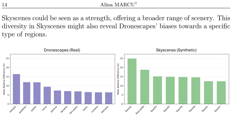
The central claim is that MMCM(I), defined for an image I as the mean pairwise pixel-level semantic agreement of N segmentation models, weighted by the geometric mean of their softmax confidences and multiplied by the square root of the mean confidence, is a valid unsupervised measure of scene complexity: lower values mean harder, more ambiguous scenes. Formalized in Equations (1)–(4), MMCM(I) lies in [0,1]; a score of 1 means perfect agreement at maximum confidence and 0 means total disagreement or zero confidence. On the two datasets used here, the mean MMCM is 0.6926 for Dronescapes and 0.5693 for Skyscenes, and the most difficult synthetic towns (Town04, Town05, Town06) show relative perceptual gaps of 30–37 percent against real scenes. The paper also claims that depth-based structural metrics—depth entropy, mean depth, and discontinuity ratio—complement MMCM by separating perceptual difficulty from physical layout, and it interprets the steeper consensus decline on synthetic depth maps as evidence that the depth model is poorly adapted to synthetic imagery. It explicitly notes that MMCM measures consistency, not correctness, giving the shared water-as-road misclassification as an example where high consensus is misleading.
Load-bearing premise
The load-bearing premise is that the agreement among three segmentation models trained on ordinary photographs faithfully measures how intrinsically complex an aerial scene is; if agreement mostly reflects familiarity with training data rather than scene difficulty, the real-versus-synthetic gap could be an artifact of training data rather than scene complexity.
Editorial extensions
If this is right
- An unsupervised complexity score can flag, before annotation, which synthetic scenes will transfer poorly to real drone operation: Town04, Town05, and Town06 show 30–37 percent relative gaps against real scenes.
- MMCM can be used as a per-frame signal for adaptive UAV behavior: low-consensus frames trigger cautious navigation, slower flight, or reliance on complementary sensors.
- Depth-derived structural metrics identify when a depth model is out of distribution; synthetic scenes with high depth entropy and declining consensus indicate that simulated depth layouts do not yet match real imagery.
- Dataset designers can use the intra-domain variability results to target specific fixes—more varied object scales, natural lighting, and realistic class imbalances—rather than treating 'synthetic' as one uniform domain.
- Scene pairs with near-zero relative gap (e.g., Town02 vs. Petrova at 0.25 percent) suggest annotation or adaptation effort can be transferred between matched synthetic and real scenes.
Reading between the lines
- If MMCM is validated against human complexity ratings, it could serve as a label-free curriculum signal for domain adaptation and active learning, prioritizing annotations on frames where model consensus is lowest.
- A testable extension: recompute MMCM with the same three architectures after fine-tuning on real aerial data; persistence of the real-vs-synthetic gap would support the scene-complexity reading, while its collapse would implicate pretraining familiarity.
- The water-as-road failure shows that consensus metrics conflate shared bias with simplicity; combining MMCM with an open-set or anomaly-aware segmentation head could separate genuine agreement from systematically wrong agreement.
- Because Skyscenes scenes are procedurally generated, intra-dataset redundancy (Town04–Town06 clustering) suggests MMCM could be used as a diversity filter to prune near-duplicate synthetic frames before training.
Signed reviews
Editorial analysis
A structured set of objections, weighed in public.
Referee Report
Summary. The paper proposes Multi-Model Consensus Metric (MMCM), an unsupervised measure of scene complexity defined as the mean pairwise agreement of semantic segmentation models, weighted by softmax confidence and multiplied by the square root of mean confidence (Eqs. 1–4). It also introduces depth-based structural metrics (depth entropy, depth gradient, discontinuity ratio, Eqs. 7–9). The experimental study compares a real aerial dataset (Dronescapes, 299 frames) with a synthetic one (Skyscenes, 264 frames) using three Cityscapes-finetuned vision transformers, reporting higher mean MMCM for real scenes (0.6926 vs 0.5693, Table 2) and interpreting this as lower perceptual complexity of real scenes. The paper further analyzes inter- and intra-domain relative gaps and correlations between MMCM and depth metrics.
Significance. The proposed metric is simple, unsupervised, and potentially useful for dataset selection and domain adaptation in aerial robotics. The paper is transparent about some limitations, notably the shared-bias issue in the water/road misclassification example. However, the central interpretive claim that MMCM measures 'perceptual complexity' is not yet validated: the metric is equally consistent with a domain-familiarity effect, as all models share ImageNet and Cityscapes training. The structural analysis is also compromised by the acknowledged unreliability of depth estimation on synthetic images. If the authors add validation against human complexity ratings or target-domain accuracy, and a control model set, the work could become a useful contribution; as it stands, the evidence is insufficient for the strong conclusions drawn.
major comments (3)
- [Section 3, Eqs. (1)–(4); Section 4, Table 2] The central claim that MMCM measures perceptual complexity is not supported because all three models share the same ImageNet pretraining and Cityscapes fine-tuning, so real aerial images are closer to the training distribution than synthetic rendered images. The higher MMCM for Dronescapes (0.6926) versus Skyscenes (0.5693) in Table 2 could therefore reflect domain familiarity rather than lower intrinsic complexity. This confound is acknowledged in the paper's own qualitative evaluation (Section 4, Figure 2), where the water surface is consistently misclassified as road by all three models; the paper attributes this to dataset bias, not scene simplicity, yet such shared bias would also inflate MMCM. The manuscript states that MMCM 'fails to account for systematic errors rooted in dataset bias' in Section 4, which directly undermines the interpretation of low consensus as high complexity. To support the complexity claim, the authors should validate MMCM against an independent ground truth of perceptual complexity (e.g., human ratings) or against measured segmentation accuracy on the target domain, and should include a control set of models with diverse pretraining (e.g., models trained only on synthetic data or without ImageNet initialization) to separate familiarity from complexity.
- [Section 4, Eqs. (7)–(9)] The structural metrics do not independently corroborate the perceptual gap. The paper reports that synthetic images show higher depth entropy and attributes this to 'faulty depth estimation' in Section 4 (Figure 5, left). If DepthAnythingV2 predictions are unreliable on synthetic images, then the depth entropy and discontinuity ratio are measures of model failure rather than scene structure, and the correlation analysis between MMCM and these metrics is not a valid structural complexity comparison. The authors should validate depth predictions against ground-truth depth maps from the Skyscenes simulator (which should be available) or restrict the structural analysis to reliable predictions, and they should report the entropy bin count B and the threshold tau used in the experiments.
- [Section 4, Table 2 and Figure 3] No error bars, confidence intervals, or significance tests are reported for the mean MMCM values or the relative gaps. With only 299 real and 264 synthetic images, and per-scene means computed from small samples (20–50 real frames, 33 synthetic frames per scene), the observed differences (e.g., the 0.25% gap between Town02 and Petrova) may not be meaningful. The paper should report per-scene standard deviations and perform a statistical test (e.g., permutation test or bootstrap) for the real-vs-synthetic difference and for the clustering claims in Figure 4.
minor comments (6)
- [Section 3, Eq. (1)] In Eq. (1), the summation notation should be clarified: the sum is over pixel coordinates (x,y), but the current text uses 'X' in the denominator without explicitly defining |I| as the number of pixels; please define the set of pixels and the notation consistently.
- [Section 4, Eq. (7)] The number of bins B for depth entropy is never reported in the experiments; please state the value used and justify the choice, ideally with a sensitivity analysis.
- [Section 4, Eq. (9)] The discontinuity ratio threshold tau is said to be 'typically set to 0.1', but no sensitivity analysis is provided; please show how the results vary with tau.
- [Figure 5] The linear regression fits are described as 'dotted lines', but the text does not report slopes, intercepts, or p-values; please include these statistics or remove the trend lines to avoid unsupported visual claims.
- [Table 2] The scene label 'Norce/Norway' is inconsistent; please choose a single spelling and use it consistently throughout the paper.
- [Section 4] The text states that images were 'rescaled to 960×540', but the source datasets have different native resolutions; please clarify the exact resizing protocol (e.g., bilinear, preserving aspect ratio) and whether this affects the depth or segmentation predictions.
Circularity Check
No significant circularity: MMCM is computed directly from model outputs with no fitted parameters, and the domain-gap numbers are empirical measurements rather than outputs of a self-referential fit.
full rationale
The derivation chain is explicit and self-contained. Equations (1)-(4) define MMCM directly from the softmax confidence and argmax predictions of three external transformer models; Equations (5)-(6) define the dataset mean and relative perceptual gap. No parameter is fitted to the data and then renamed as a prediction: the reported values 0.6926 for Dronescapes and 0.5693 for Skyscenes are direct means of the defined statistic. The paper's own Section 4 explicitly labels the high-agreement water surface example as a case where consensus follows from a shared dataset bias ('the models consistently misclassify the water surface as a road'), which is a stated limitation of the metric's construct validity rather than a circular step in the derivation. Similarly, the depth-based metrics (Eqs. 7-9) are deterministic functions of DepthAnythingV2 outputs; the paper's admission that synthetic entropy is 'highly due to faulty depth estimation' is a measurement-validity caveat, not an input that is propagated through the equations to force the claimed result. The only self-citations, Dronescapes [19] and Semantics through time [18], supply the real-world dataset and prior aerial segmentation context; they are not invoked as an unverified theorem that forces the conclusion. Because MMCM's interpretation as 'perceptual complexity' is stipulated in Section 3 ('lower consensus translates to higher scene complexity due to its characteristics') rather than derived, the paper's central quantitative gap is an empirical statement about model consensus; the complexity label is an interpretive choice whose external validity is unvalidated but not circularly derived. No circular step satisfying the exhibited-reduction requirement was found.
Assumptions & free parameters
free parameters (3)
- discontinuity threshold tau =
0.1
- depth entropy bin count B
- choice of segmentation models =
3 models: Mask2Former, OneFormer, SegFormer
assumptions (4)
- domain assumption Agreement and confidence among three Cityscapes-finetuned transformers is a valid proxy for perceptual scene complexity.
- domain assumption DepthAnythingV2 depth predictions accurately reflect true depth structure in both real and synthetic aerial images.
- domain assumption Dronescapes and the Skyscenes subset are representative of the real and synthetic aerial domains.
- domain assumption The Cityscapes class set of 19 classes is adequate for scoring aerial scenes.
Cite this review
Pith. "Pith review of Quantifying the synthetic and real domain gap in aerial scene understanding." pith.science (2026). https://pith.science/paper/ZJ6VJHUF
@misc{pith2026241119913,
  author       = {Pith},
  title        = {Pith review of: Quantifying the synthetic and real domain gap in aerial scene understanding},
  year         = {2026},
  howpublished = {\url{https://pith.science/paper/ZJ6VJHUF}},
  note         = {Machine review of arXiv:2411.19913}
}
read the original abstract
Quantifying the gap between synthetic and real-world imagery is essential for improving both transformer-based models - that rely on large volumes of data - and datasets, especially in underexplored domains like aerial scene understanding where the potential impact is significant. This paper introduces a novel methodology for scene complexity assessment using Multi-Model Consensus Metric (MMCM) and depth-based structural metrics, enabling a robust evaluation of perceptual and structural disparities between domains. Our experimental analysis, utilizing real-world (Dronescapes) and synthetic (Skyscenes) datasets, demonstrates that real-world scenes generally exhibit higher consensus among state-of-the-art vision transformers, while synthetic scenes show greater variability and challenge model adaptability. The results underline the inherent complexities and domain gaps, emphasizing the need for enhanced simulation fidelity and model generalization. This work provides critical insights into the interplay between domain characteristics and model performance, offering a pathway for improved domain adaptation strategies in aerial scene understanding.
Figures


Figures from the paper (2 more)

Forward citations
Cited by 1 Pith paper
-
Multi-modal video data-pipelines for machine learning with minimal human supervision
An open-source video pipeline automatically extracts 13+ visual modalities from raw video with no human annotation, and a sub-1M-parameter distilled model reaches near-Mask2Former accuracy on an aerial scene benchmark.
Reference graph
Works this paper leans on
-
[1]
Quantifying the synthetic and real domain gap in aerial scene understanding
Introduction Robotics aims to develop physical agents capable of interacting with the real world, where vision plays a crucial role in perception and scene un- derstanding. Advanced artificial intelligence (AI) systems depend on various learning paradigms. These include data-driven approaches (supervised or un- supervised) and experience-based methods (re...
work page Pith review arXiv 2024
-
[2]
Aerial Scene Understanding Scene understanding involves a broad range of tasks that can be catego- rized into five key domains: (1) object-centric tasks, focusing on the detection, Quantifying the Synthetic and Real Domain Gap in Aerial Scene Understanding 3 Figure 1. Overview of the main challenges for aerial scene un- derstanding: A) Environmental and a...
work page 2023
-
[3]
Multi-Model Consensus Metric (MMCM) We propose a novel approach to measure the complexity of a scene, char- acterized by a set of frames/images, through the lens of pretrained vision transformers, without the need of labeled data. Our methodology leverages both perceptual complexity, measured via multi-model consensus, and struc- tural complexity, capture...
-
[4]
8 Alina MARCU 1 Datasets details
Experimental Analysis For our experimental analysis, we used two of the most recent and rep- resentative datasets that provide complementary perspectives for aerial scene understanding (synthetic [13] and real [19] imagery). 8 Alina MARCU 1 Datasets details. The first dataset, Dronescapes [19] consists of videos col- lected from real-world drone flights w...
-
[5]
Conclusion This study highlights the importance of understanding the complexity of a scene in bridging the sim-to-real gap for comprehensive aerial scene un- derstanding. By introducing MMCM, a model-agnostic metric for evaluating perceptual complexity, a multi-model consistency metric, and complementing it with depth-based structural metrics, we provide ...
-
[6]
Forest Inspection Dataset for Aerial Semantic Segmentation and Depth Estimation
B.-C.-Z. Blaga and S. Nedevschi. Forest inspection dataset for aerial semantic segmen- tation and depth estimation. arXiv preprint arXiv:2403.06621 , 2024
work page Pith review arXiv 2024
-
[7]
W. Cai, K. Jin, J. Hou, C. Guo, L. Wu, and W. Yang. Vdd: Varied drone dataset for semantic segmentation. arXiv preprint arXiv:2305.13608 , 2023
arXiv 2023
-
[8]
Cheng, I
B. Cheng, I. Misra, A. G. Schwing, A. Kirillov, and R. Girdhar. Masked-attention mask transformer for universal image segmentation. 2022
2022
Show all 30 references
-
[9]
Choe, A.-H
S.-A. Choe, A.-H. Shin, K.-H. Park, J. Choi, and G.-M. Park. Open-set domain adapta- tion for semantic segmentation. In Proceedings of the IEEE/CVF Conference on Com- puter Vision and Pattern Recognition , pages 23943–23953, 2024
2024
-
[10]
Cordts, M
M. Cordts, M. Omran, S. Ramos, T. Rehfeld, M. Enzweiler, R. Benenson, U. Franke, S. Roth, and B. Schiele. The cityscapes dataset for semantic urban scene understanding. In Proceedings of the IEEE conference on computer vision and pattern recognition, pages 3213–3223, 2016
2016
-
[11]
J. Deng, W. Dong, R. Socher, L.-J. Li, K. Li, and L. Fei-Fei. Imagenet: A large-scale hierarchical image database. In 2009 IEEE conference on computer vision and pattern recognition, pages 248–255. Ieee, 2009
2009
-
[12]
Dosovitskiy, L
A. Dosovitskiy, L. Beyer, A. Kolesnikov, D. Weissenborn, X. Zhai, T. Unterthiner, M. Dehghani, M. Minderer, G. Heigold, S. Gelly, J. Uszkoreit, and N. Houlsby. An image is worth 16x16 words: Transformers for image recognition at scale. ArXiv, abs/2010.11929, 2020
2010 arXiv
-
[13]
D. Du, Y. Qi, H. Yu, Y. Yang, K. Duan, G. Li, W. Zhang, Q. Huang, and Q. Tian. The unmanned aerial vehicle benchmark: Object detection and tracking. In Proceedings of the European conference on computer vision (ECCV) , pages 370–386, 2018
2018
-
[14]
Geiger, P
A. Geiger, P. Lenz, C. Stiller, and R. Urtasun. Vision meets robotics: The kitti dataset. The International Journal of Robotics Research , 32(11):1231–1237, 2013
2013
-
[15]
Z. Guo, Y. Huang, X. Hu, H. Wei, and B. Zhao. A survey on deep learning based approaches for scene understanding in autonomous driving.Electronics, 10(4):471, 2021
2021
-
[16]
J. Jain, J. Li, M. T. Chiu, A. Hassani, N. Orlov, and H. Shi. Oneformer: One trans- former to rule universal image segmentation. In Proceedings of the IEEE/CVF Confer- ence on Computer Vision and Pattern Recognition , pages 2989–2998, 2023
2023
-
[17]
Kanopoulos, N
N. Kanopoulos, N. Vasanthavada, and R. L. Baker. Design of an image edge detection filter using the sobel operator. IEEE Journal of solid-state circuits, 23(2):358–367, 1988
1988
-
[18]
Khose, A
S. Khose, A. Pal, A. Agarwal, J. Hoffman, P. Chattopadhyay, et al. Skyscenes: A synthetic dataset for aerial scene understanding.arXiv preprint arXiv:2312.06719, 2023
2023 arXiv
-
[19]
Kolbeinsson and K
B. Kolbeinsson and K. Mikolajczyk. Ddos: The drone depth and obstacle segmentation dataset. In Proceedings of the IEEE/CVF Conference on Computer Vision and Pattern Recognition (CVPR) Workshops, pages 7328–7337, June 2024
2024
-
[20]
C. Lee, M. Anderson, N. Raganathan, X. Zuo, K. Do, G. Gkioxari, and S.-J. Chung. Cart: Caltech aerial rgb-thermal dataset in the wild. arXiv preprint arXiv:2403.08997 , 2024. Quantifying the Synthetic and Real Domain Gap in Aerial Scene Understanding 17
2024 arXiv
-
[21]
F. Liu, L. Yao, S. Xu, C. Zhang, X. Zhang, and T. Wu. Uemm-air: A synthetic multi-modal dataset for unmanned aerial vehicle object detection. arXiv preprint arXiv:2406.06230, 2024
2024 arXiv
-
[22]
Maiti, S
A. Maiti, S. Oude Elberink, and G. Vosselman. Uavpal: A new dataset for semantic segmentation in complex urban landscape with efficient multi-scale segmentation.IEEE Journal of Selected Topics in Applied Earth Observations and Remote Sensing , 2023
2023
-
[23]
Marcu, V
A. Marcu, V. Licaret, D. Costea, and M. Leordeanu. Semantics through time: Semi- supervised segmentation of aerial videos with iterative label propagation. InProceedings of the Asian Conference on Computer Vision , 2020
2020
-
[24]
Marcu, M
A. Marcu, M. Pirvu, D. Costea, E. Haller, E. Slusanschi, A. N. Belbachir, R. Suk- thankar, and M. Leordeanu. Self-supervised hypergraphs for learning multiple world interpretations. In Proceedings of the IEEE/CVF International Conference on Com- puter Vision , pages 983–992, 2023
2023
-
[25]
Menouar, I
H. Menouar, I. Guvenc, K. Akkaya, A. S. Uluagac, A. Kadri, and A. Tuncer. Uav- enabled intelligent transportation systems for the smart city: Applications and chal- lenges. IEEE Communications Magazine , 55(3):22–28, 2017
2017
-
[26]
L. P. Osco, J. M. Junior, A. P. M. Ramos, L. A. de Castro Jorge, S. N. Fatholahi, J. de Andrade Silva, E. T. Matsubara, H. Pistori, W. N. Gon¸ calves, and J. Li. A review on deep learning in uav remote sensing. International Journal of Applied Earth Observation and Geoinformat...
2021
-
[27]
Rizzoli, F
G. Rizzoli, F. Barbato, M. Caligiuri, and P. Zanuttigh. Syndrone-multi-modal uav dataset for urban scenarios. In Proceedings of the IEEE/CVF International Conference on Computer Vision , pages 2210–2220, 2023
2023
-
[28]
J. Suo, T. Wang, X. Zhang, H. Chen, W. Zhou, and W. Shi. Hit-uav: A high-altitude infrared thermal dataset for unmanned aerial vehicle-based object detection. Scientific Data, 10(1):227, 2023
2023
-
[29]
E. Xie, W. Wang, Z. Yu, A. Anandkumar, J. M. Alvarez, and P. Luo. Segformer: Simple and efficient design for semantic segmentation with transformers. Advances in neural information processing systems, 34:12077–12090, 2021
2021
-
[30]
L. Yang, B. Kang, Z. Huang, Z. Zhao, X. Xu, J. Feng, and H. Zhao. Depth anything v2. arXiv preprint arXiv:2406.09414 , 2024
2024 arXiv
Reviewed August 12, 2026 · model on record in the stance chip above.
Discussion (0). Continue with ORCID to comment.