REVIEW 5 major objections 7 minor 59 references
3DTTNet: Multimodal Fusion-Based 3D Traversable Terrain Modeling for Off-Road Environments
T0 review · 5 major / 7 minor · reviewed 2026-08-11 · deepseek-v4-flash
Pith's one-line read 3DTTNet claims that fusing LiDAR with monocular images via deformable attention improves 3D traversable terrain recognition, scoring 49.78 vs 34.92 scene completion IoU on the new RELLIS-OCC dataset—a 42% relative gain—and introduces a…
desk verdict A useful dataset and a sensible architecture, undercut by an internally inconsistent labeling rule and the authors' own admission of wrong ground-truth labels. read the letter →
The pith
A machine-rendered reading of the paper's core claim, the machinery that carries it, and where it could break.
The reading
What carries the argument
Three components carry the argument. First, deformable attention fusion: voxel queries are projected onto the 2D image feature map, where deformable cross-attention samples features at learned offsets around each projected point (Eq. 1), and deformable self-attention then refines the 3D voxel features; mask tokens represent empty space and a query-upscale network provides lower-resolution occupancy supervision. Second, the RELLIS-OCC labeling pipeline: point clouds are voxelized at 0.2 m into a 192×256×40 grid; local geometric features—step height h, slope s, and unevenness u—are computed from a circular neighborhood of each voxel, and the Geometric Passability Assessment Mask, GPAM(Gj) = [Ψver ∧ Ψtre ∧ Ψove ∧ Ψslo], flags voxels that fail vehicle obstacle-crossing conditions as lethal; the geometric risk φgeo = h/hmax + s/smax + u/ucritic with thresholds τmedium and τlow assigns medium-, low-, or free cost to the rest. Third, the training loss combines weighted cross-entropy with semantic and geometric scale losses that directly maximize class-wise precision, recall, and specificity.
What would settle it
Instrument a test vehicle and drive it across voxel regions that RELLIS-OCC labels lethal, medium-cost, low-cost, and free, using the same vehicle parameters encoded in the pipeline, and compare each label with the observed outcome (successful crossing, suspension impact, wheel slip, or immobilization). If lethal-labeled regions are routinely crossed without difficulty or free-labeled regions damage the vehicle, the label pipeline is not measuring traversability and the 42% scene completion IoU gain is measured against an invalid standard; a narrower check is that Eq. (24) and Algorithm 1 disagree on when Free applies, so re-running the published labeler on RELLIS-3D would settle what rule was actually used.
Extended reading notes
Core claim
On the paper's own terms, the central discovery is that semantic scene completion—predicting, for every voxel in a forward-facing 3D grid, whether it is empty or occupied by a traversability-cost class—works as a unifying representation for off-road terrain modeling. The authors claim that 3DTTNet 'outperforms the comparison approaches in 3D traversable area recognition,' with the headline numbers being an SC IoU of 49.78 against 34.92 for MonoScene, which they report as a 42% improvement, and an SSC mIoU of 15.70. They attribute this to the combination of LiDAR geometry with image semantics through deformable cross- and self-attention, and they introduce the RELLIS-OCC dataset and its rule-based annotation pipeline as the benchmark that makes the evaluation possible. The qualitative results additionally claim that the model infers occluded obstacles such as rock piles and trees as lethal regions, including cases where the pipeline-generated ground truth itself is inconsistent.
Load-bearing premise
The rule-based pipeline that produces the RELLIS-OCC traversability labels is assumed to be a correct measure of real vehicle passability; if the semantic-to-cost mapping, the GPAM passability checks, or the thresholds τmedium and τlow are wrong or inconsistently applied, the reported IoU values do not describe how a vehicle can actually move.
Editorial extensions
If this is right
- Occluded terrain—areas hidden behind vegetation, rocks, or other obstacles—appears in the output as completed 3D occupancy, not just as visible surface measurements.
- The four-grade traversability representation (lethal, medium-cost, low-cost, free) gives downstream planners graded cost information in voxel space instead of a binary safe/unsafe map.
- Because the label pipeline is parameterized by vehicle properties such as wheel radius, wheelbase, center of gravity, suspension travel, and ground clearance, the same network and labeling approach can be recalibrated for different vehicle platforms.
- On RELLIS-OCC, models that use both LiDAR and images outperform LiDAR-only semantic completion models, supporting the paper's claim that multimodal input is necessary for accurate traversability estimation in off-road scenes.
- The real-vehicle tests integrate the predicted cost map into Hybrid A* with Reeds-Shepp smoothing and report collision-free trajectories in cliff, forest, pit, and rutted-terrain scenarios, demonstrating that the 3D map can drive planning directly.
Reading between the lines
- Editorial inference: the 42% scene completion IoU gain is only as meaningful as the RELLIS-OCC labels; since the annotation pipeline has not been validated against actual vehicle crossings, some of the advantage over baselines could reflect label artifacts that favor 3DTTNet's inductive bias rather than true passability.
- Editorial inference: the paper's own visualization of rocky piles shows ground truth labeling flat areas inside the pile as traversable while 3DTTNet marks them lethal, suggesting the learned model can disagree with and sometimes correct its own training labels; whether that helps or hurts the reported metrics depends on what the intended evaluation standard is.
- Editorial inference: a natural, testable extension is to replace the two thresholds τmedium and τlow with a full vehicle-dynamics model—predicting wheel slip, chassis acceleration, or suspension loads—since the paper names dynamic-model integration as future work and the network architecture would not need to change.
- Editorial inference: because the fusion projects voxels to image features at the current frame, the method's advantage may shrink under large viewpoint changes or near-total occlusion; accumulating features over multiple frames, a design the paper does not test, would be a direct comparison that could separate temporal reasoning from single-frame fusion.
Editorial analysis
A structured set of objections, weighed in public.
Referee Report
Summary. The paper proposes 3DTTNet, a multimodal semantic scene completion network for 3D traversable terrain modeling in off-road environments. The network fuses monocular images and LiDAR point clouds with deformable cross- and self-attention to predict dense voxel traversability labels. The authors also introduce RELLIS-OCC, a dataset with 3D traversability cost annotations generated by a rule-based pipeline combining semantic category mapping and a geometric passability assessment mask (GPAM) based on vehicle obstacle-crossing conditions. Quantitative experiments on RELLIS-OCC report an SC IoU of 49.78 for 3DTTNet versus 34.92 for MonoScene, which the paper describes as a 42% improvement, along with qualitative real-vehicle tests and trajectory planning demonstrations. The paper claims that 3DTTNet outperforms existing approaches in 3D traversable area recognition, particularly for irregular geometries and partial occlusions.
Significance. If the reported results were backed by a reproducible and validated label protocol, the contribution would be significant: RELLIS-OCC would be a useful resource for off-road traversability research, and the idea of integrating vehicle geometric constraints into dense 3D traversability labels is valuable. The architecture itself, with multimodal deformable attention, is reasonable and the real-vehicle demonstrations are a commendable step. However, the quantitative claim rests on ground-truth labels that are internally inconsistent and partly admitted to be wrong, and the main comparison is confounded by sensor modality differences. The paper's contribution is therefore currently more in the proposed dataset and qualitative demonstration than in the demonstrated state-of-the-art performance.
major comments (5)
- [Section III-B, Eq. (24) vs Algorithm 1] The labeling rule is internally inconsistent. Eq. (24) makes Free conditional on S(Gj) ∈ Sfree and φgeo < τlow, leaving Straversable voxels with φgeo < τlow undefined, whereas Algorithm 1 assigns Free to all voxels with φgeo < τlow regardless of semantic category. Algorithm 1 also assigns Free to all Sfree voxels without evaluating GPAM, while Eq. (24) makes GPAM=0 lethal for all voxels. Because the two specifications produce different labels, the dataset's ground truth is not uniquely defined.
- [Section III-B, Eqs. (26)-(27) and Algorithm 1] The threshold parameters ηmedium and ηlow, the vehicle parameters (r, l, a, µ, zsusp, zclearance, Fmax, m), and the neighborhood radius Ω used in Eqs. (11)–(13) are not reported. These values directly determine the traversability labels, and hence every IoU in Table II. Without them the labels cannot be reproduced or independently evaluated.
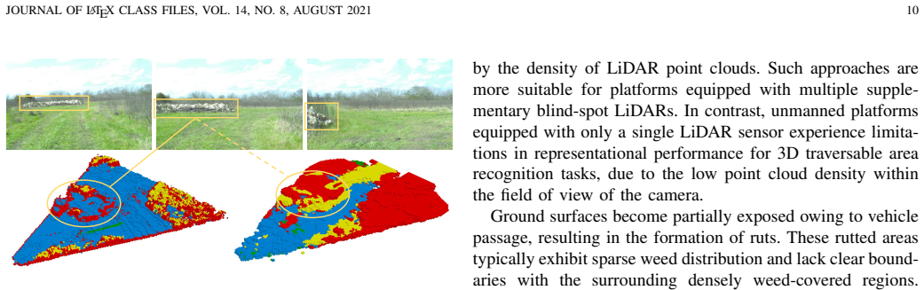
- [Section IV-B, Fig. 7] The text states that the ground truth "incorrectly assigns labels to the flat areas within the rocky pile" while 3DTTNet "correctly infers the entire rocky pile as lethal." This is an explicit admission that the benchmark labels are wrong in at least one scene. Since all metrics in Table II are computed against this same ground truth, the reported performance advantage does not necessarily reflect true traversability.
- [Table II and Section IV-A] The headline comparison is not modality-fair: MonoScene uses only monocular images, whereas 3DTTNet also receives LiDAR point clouds. The reported 42% SC IoU improvement is relative to MonoScene (49.78 vs 34.92) and may partly reflect the extra sensor modality. Reporting a monocular-only or LiDAR-only variant of 3DTTNet, or comparing with baselines using the same inputs, is necessary to support the architectural superiority claim.
- [Section IV-A] No error bars, multiple seeds, or ablations are reported. Each method is trained once for 20 epochs, so the observed differences, some of which are small (e.g., free-class IoU 5.41 vs 5.51), could be within training noise. Multiple seeds with means and standard deviations, plus ablations for the deformable attention and mask-token components, are needed.
minor comments (7)
- [Eq. (5)] The cross-entropy formula is malformed; the term '− log( M Σ c=1 e^{y_i,c})' appears without proper probability normalization and with mismatched parentheses.
- [Eqs. (6)-(8)] The definitions of precision, recall, and specificity include a logarithm and are not standard; the text should explain why the logarithm is used and how these relate to the standard metrics.
- [Section III-B.2] The text says the neighborhood of each voxel is defined as a circular region Ω but does not specify the radius value or how the radius is selected; this is also needed for reproducibility.
- [Fig. 6] The caption says rows 5–10 show predictions from alternative algorithms, but there are six alternative algorithms plus 3DTTNet; the row numbering should be checked.
- [Section III-B.4] The set Sfree = {hard-surface, mud, rubble} is labeled 'free' by assumption, but mud and rubble can be high-cost for many vehicles; the choice should be justified or parameterized by vehicle type.
- [Section III-B] The paper does not describe a test split; only training sequences 00000–00003 and validation sequence 00004 are mentioned, so it is unclear which data produced Table II.
- [General] There are several typos and formatting issues: 'arround' in Section III-B.2, 'V oxel' in Algorithm 1, and 'Remaped Label' in the Fig. 7 caption.
Circularity Check
No significant circularity: 3DTTNet is trained and evaluated against an explicit rule-based label pipeline that is independent of the network's predictions; the reported IoU gains are empirical benchmark results, not consequences of the model's construction.
full rationale
The derivation chain is straightforward supervised learning. LiDAR and monocular images are processed by feature extractors, deformable attention layers, and a softmax head to produce traversability predictions; the loss in Eq. (4) compares those predictions with RELLIS-OCC labels. The labels are generated by a separate pipeline (semantic remapping plus the GPAM geometric rule in Eqs. (10)-(27) and Algorithm 1), and no equation in the paper defines the model's output in terms of the labels or vice versa except the ordinary training objective. The central quantitative claim, a 42% SC IoU improvement, is computed by evaluating all methods against the same RELLIS-OCC ground truth, so the comparison among methods is not forced by construction. No fitted parameter of 3DTTNet is renamed as a prediction, and no load-bearing conclusion rests on a self-citation; the only author-overlapping citation (ORFD, Ref. [18]) is used for dataset comparison in related work and is not load-bearing. There are legitimate benchmark-validity concerns: Eq. (24) and Algorithm 1 disagree about when voxels are labeled Free, the threshold factors eta_medium and eta_low are not reported, and Section IV-B admits that the ground truth incorrectly labels flat areas inside a rocky pile. These affect the correctness, reproducibility, and interpretation of the reported IoU numbers, but they are not circularity: the model does not define or derive the label rule, and the label rule does not derive the model's performance. The paper is therefore not circular, even though the benchmark's ground truth is imperfectly specified.
Assumptions & free parameters
free parameters (3)
- ηmedium and ηlow (threshold scaling factors) =
Not reported
- Vehicle parameters for GPAM (r, l, a, µ, zsusp, zclearance, Fmax, m) =
Not reported
- Neighborhood radius Ω for geometric features =
Not reported
assumptions (3)
- domain assumption The vehicle obstacle crossing equations (Eqs. 14-21) from Wong [52] and Ganganath [53] are valid for the Warthog platform and the off-road terrain in RELLIS-3D.
- ad hoc to paper Semantic categories have fixed inherent traversability: Slethal={person, object, barrier, tree}, Straversable={water, soil, bush, grass}, Sfree={hard-surface, mud, rubble}.
- domain assumption Traversability is determined solely by the four geometric conditions in GPAM (vertical, trench, overhang, slope), combined with semantic mapping.
Cite this review
Pith. "Pith review of 3DTTNet: Multimodal Fusion-Based 3D Traversable Terrain Modeling for Off-Road Environments." pith.science (2026). https://pith.science/paper/4X56FJGU
@misc{pith2026241208195,
  author       = {Pith},
  title        = {Pith review of: 3DTTNet: Multimodal Fusion-Based 3D Traversable Terrain Modeling for Off-Road Environments},
  year         = {2026},
  howpublished = {\url{https://pith.science/paper/4X56FJGU}},
  note         = {Machine review of arXiv:2412.08195}
}
read the original abstract
Off-road environments remain significant challenges for autonomous ground vehicles, due to the lack of structured roads and the presence of complex obstacles, such as uneven terrain, vegetation, and occlusions. Traditional perception algorithms, primarily designed for structured environments, often fail in unstructured scenarios. In this paper, traversable area recognition is achieved through semantic scene completion. A novel multimodal method, 3DTTNet, is proposed to generate dense traversable terrain estimations by integrating LiDAR point clouds with monocular images from a forward-facing perspective. By integrating multimodal data, environmental feature extraction is strengthened, which is crucial for accurate terrain modeling in complex terrains. Furthermore, RELLIS-OCC, a dataset with 3D traversable annotations, is introduced, incorporating geometric features such as step height, slope, and unevenness. Through a comprehensive analysis of vehicle obsta cle-crossing conditions and the incorporation of vehicle body structure constraints, four traversability cost labels are generated: lethal, medium-cost, low-cost, and free. Experimental results demonstrate that 3DTTNet outperforms the comparison approaches in 3D traversable area recognition, particularly in off-road environments with irregular geometries and partial occlusions. Specifically, 3DTTNet achieves a 42\% improvement in scene completion IoU compared to other models. The proposed framework is scalable and adaptable to various vehicle platforms, allowing for adjustments to occupancy grid parameters and the integration of advanced dynamic models for traversability cost estimation.
Figures


Figures from the paper (10 more)




Reference graph
Works this paper leans on
-
[1]
Vision meets robotics: The kitti dataset,
A. Geiger, P. Lenz, C. Stiller, and R. Urtasun, “Vision meets robotics: The kitti dataset,” The International Journal of Robotics Research , vol. 32, no. 11, pp. 1231–1237, 2013
2013
-
[2]
nuscenes: A multi- modal dataset for autonomous driving,
H. Caesar, V . Bankiti, A. H. Lang, S. V ora, V . E. Liong, Q. Xu, A. Krishnan, Y . Pan, G. Baldan, and O. Beijbom, “nuscenes: A multi- modal dataset for autonomous driving,” in Proceedings of the IEEE/CVF conference on computer vision and pattern recognition , pp. 11621– 11631, 2020
2020
-
[3]
Scalability in perception for autonomous driving: Waymo open dataset,
P. Sun, H. Kretzschmar, X. Dotiwalla, A. Chouard, V . Patnaik, P. Tsui, J. Guo, Y . Zhou, Y . Chai, B. Caine, et al. , “Scalability in perception for autonomous driving: Waymo open dataset,” in Proceedings of the IEEE/CVF conference on computer vision and pattern recognition , pp. 2446–2454, 2020
2020
-
[4]
Pointnet: Deep learning on point sets for 3d classification and segmentation,
C. R. Qi, H. Su, K. Mo, and L. J. Guibas, “Pointnet: Deep learning on point sets for 3d classification and segmentation,” in Proceedings of the IEEE conference on computer vision and pattern recognition , pp. 652– 660, 2017
2017
-
[5]
Pointnet++: Deep hierarchical feature learning on point sets in a metric space,
C. R. Qi, L. Yi, H. Su, and L. J. Guibas, “Pointnet++: Deep hierarchical feature learning on point sets in a metric space,” Advances in neural information processing systems , vol. 30, 2017
2017
-
[6]
V oxelnet: End-to-end learning for point cloud based 3d object detection,
Y . Zhou and O. Tuzel, “V oxelnet: End-to-end learning for point cloud based 3d object detection,” in Proceedings of the IEEE conference on computer vision and pattern recognition , pp. 4490–4499, 2018
2018
-
[7]
Tri-perspective view for vision-based 3d semantic occupancy prediction,
Y . Huang, W. Zheng, Y . Zhang, J. Zhou, and J. Lu, “Tri-perspective view for vision-based 3d semantic occupancy prediction,” in Proceedings of the IEEE/CVF conference on computer vision and pattern recognition , pp. 9223–9232, 2023
work page 2023
-
[8]
Openoccupancy: A large scale benchmark for surrounding semantic occupancy perception,
X. Wang, Z. Zhu, W. Xu, Y . Zhang, Y . Wei, X. Chi, Y . Ye, D. Du, J. Lu, and X. Wang, “Openoccupancy: A large scale benchmark for surrounding semantic occupancy perception,” in Proceedings of the IEEE/CVF International Conference on Computer Vision , pp. 17850– 17859, 2023
work page 2023
Show all 59 references
-
[9]
Surroundocc: Multi-camera 3d occupancy prediction for autonomous driving,
Y . Wei, L. Zhao, W. Zheng, Z. Zhu, J. Zhou, and J. Lu, “Surroundocc: Multi-camera 3d occupancy prediction for autonomous driving,” in Proceedings of the IEEE/CVF International Conference on Computer Vision, pp. 21729–21740, 2023
2023
-
[10]
The canadian planetary emulation terrain 3d mapping dataset,
C. H. Tong, D. Gingras, K. Larose, T. D. Barfoot, and ´E. Dupuis, “The canadian planetary emulation terrain 3d mapping dataset,” The International Journal of Robotics Research , vol. 32, no. 4, pp. 389– 395, 2013
2013
-
[11]
Deep multi- spectral semantic scene understanding of forested environments using multimodal fusion,
A. Valada, G. L. Oliveira, T. Brox, and W. Burgard, “Deep multi- spectral semantic scene understanding of forested environments using multimodal fusion,” in 2016 International Symposium on Experimental Robotics, pp. 465–477, Springer, 2017
2016
-
[13]
A rugd dataset for autonomous navigation and visual perception in unstructured outdoor environments,
M. Wigness, S. Eum, J. G. Rogers, D. Han, and H. Kwon, “A rugd dataset for autonomous navigation and visual perception in unstructured outdoor environments,” in 2019 IEEE/RSJ International Conference on Intelligent Robots and Systems (IROS) , pp. 5000–5007, IEEE, 2019
2019
-
[14]
An off-road terrain dataset including images labeled with measures of terrain roughness,
G. Gresenz, J. White, and D. C. Schmidt, “An off-road terrain dataset including images labeled with measures of terrain roughness,” in 2021 IEEE International Conference on Autonomous Systems (ICAS), pp. 1–5, IEEE, 2021
2021
-
[15]
Rellis-3d dataset: Data, benchmarks and analysis,
P. Jiang, P. Osteen, M. Wigness, and S. Saripalli, “Rellis-3d dataset: Data, benchmarks and analysis,” in 2021 IEEE international conference on robotics and automation (ICRA) , pp. 1110–1116, IEEE, 2021
2021
-
[16]
Rooad: Rellis off-road odometry analysis dataset,
G. Chustz and S. Saripalli, “Rooad: Rellis off-road odometry analysis dataset,” in 2022 IEEE Intelligent Vehicles Symposium (IV) , pp. 1504– 1510, IEEE, 2022
2022
-
[17]
Cat: Cavs traversabil- ity dataset for off-road autonomous driving,
S. Sharma, L. Dabbiru, T. Hannis, G. Mason, D. W. Carruth, M. Doude, C. Goodin, C. Hudson, S. Ozier, J. E. Ball, et al., “Cat: Cavs traversabil- ity dataset for off-road autonomous driving,” IEEE Access , vol. 10, pp. 24759–24768, 2022
2022
-
[18]
Orfd: A dataset and benchmark for off-road freespace detection,
C. Min, W. Jiang, D. Zhao, J. Xu, L. Xiao, Y . Nie, and B. Dai, “Orfd: A dataset and benchmark for off-road freespace detection,” in 2022 international conference on robotics and automation (ICRA) , pp. 2532– 2538, IEEE, 2022
2022
-
[19]
The synthetic off-road trail dataset for unmanned motorcycle,
T. Yan, X. Zheng, W. Liu, B. Liang, and Z. Chen, “The synthetic off-road trail dataset for unmanned motorcycle,” in 2022 IEEE 95th Vehicular Technology Conference:(VTC2022-Spring), pp. 1–7, IEEE, 2022. JOURNAL OF LATEX CLASS FILES, VOL. 14, NO. 8, AUGUST 2021 14
2022
-
[20]
Tartandrive: A large-scale dataset for learning off-road dynamics models,
S. Triest, M. Sivaprakasam, S. J. Wang, W. Wang, A. M. Johnson, and S. Scherer, “Tartandrive: A large-scale dataset for learning off-road dynamics models,” in 2022 International Conference on Robotics and Automation (ICRA), pp. 2546–2552, IEEE, 2022
2022
-
[21]
Waterscenes: A multi-task 4d radar-camera fusion dataset and benchmarks for autonomous driving on water surfaces,
S. Yao, R. Guan, Z. Wu, Y . Ni, Z. Huang, R. W. Liu, Y . Yue, W. Ding, E. G. Lim, H. Seo, et al. , “Waterscenes: A multi-task 4d radar-camera fusion dataset and benchmarks for autonomous driving on water surfaces,” IEEE Transactions on Intelligent Transportation Systems, 2024
2024
-
[22]
Wild-places: A large-scale dataset for lidar place recognition in unstructured natural environments,
J. Knights, K. Vidanapathirana, M. Ramezani, S. Sridharan, C. Fookes, and P. Moghadam, “Wild-places: A large-scale dataset for lidar place recognition in unstructured natural environments,” in2023 IEEE interna- tional conference on robotics and automation (ICRA), pp. 11322–113...
2023
-
[23]
The goose dataset for perception in unstructured environments,
P. Mortimer, R. Hagmanns, M. Granero, T. Luettel, J. Petereit, and H.-J. Wuensche, “The goose dataset for perception in unstructured environments,” in 2024 IEEE International Conference on Robotics and Automation (ICRA), pp. 14838–14844, IEEE, 2024
2024
-
[24]
Tartandrive 2.0: More modalities and better infrastructure to further self-supervised learning research in off-road driving tasks,
M. Sivaprakasam, P. Maheshwari, M. G. Castro, S. Triest, M. Nye, S. Willits, A. Saba, W. Wang, and S. Scherer, “Tartandrive 2.0: More modalities and better infrastructure to further self-supervised learning research in off-road driving tasks,” arXiv preprint arXiv:2402.01913 , 2024
2024 arXiv
-
[25]
Classifier fusion for outdoor obstacle detection,
C. S. Dima, N. Vandapel, and M. Hebert, “Classifier fusion for outdoor obstacle detection,” in IEEE International Conference on Robotics and Automation, 2004. Proceedings. ICRA’04. 2004 , vol. 1, pp. 665–671, IEEE, 2004
2004
-
[26]
Vegetation detection for mobile robot navigation,
D. Bradley, S. Thayer, A. Stentz, and P. Rander, “Vegetation detection for mobile robot navigation,”Robotics Institute, Carnegie Mellon University, Pittsburgh, PA, Tech. Rep. CMU-RI-TR-04-12 , 2004
2004
-
[27]
Self-supervised monocular road detection in desert terrain.,
H. Dahlkamp, A. Kaehler, D. Stavens, S. Thrun, and G. R. Brad- ski, “Self-supervised monocular road detection in desert terrain.,” in Robotics: science and systems , vol. 38, Philadelphia, 2006
2006
-
[28]
Probabilistic traversability map generation using 3d-lidar and camera,
J. Sock, J. Kim, J. Min, and K. Kwak, “Probabilistic traversability map generation using 3d-lidar and camera,” in 2016 IEEE international conference on robotics and automation (ICRA) , pp. 5631–5637, IEEE, 2016
2016
-
[29]
Lidar based off-road negative obstacle detection and analysis,
J. Larson and M. Trivedi, “Lidar based off-road negative obstacle detection and analysis,” in 2011 14th International IEEE Conference on Intelligent Transportation Systems (ITSC) , pp. 192–197, IEEE, 2011
2011
-
[30]
Cooperative multi-robot observation of multiple moving targets based on contribution model,
Z. W.-J. Y ANG Jian-Hua and W. Zhao-Hui, “Cooperative multi-robot observation of multiple moving targets based on contribution model,” Pattern Recognition and Artificial Intelligence, vol. 28, no. 04, pp. 335– 343, 2015
2015
-
[31]
Learning to drive: End-to-end off-road path prediction,
C. J. Holder and T. P. Breckon, “Learning to drive: End-to-end off-road path prediction,” IEEE Intelligent Transportation Systems Magazine , vol. 13, no. 2, pp. 217–221, 2019
2019
-
[32]
Traversability mapping in off-road environment using semantic segmentation,
L. Dabbiru, S. Sharma, C. Goodin, S. Ozier, C. Hudson, D. Carruth, M. Doude, G. Mason, and J. Ball, “Traversability mapping in off-road environment using semantic segmentation,” in Autonomous Systems: Sensors, Processing, and Security for Vehicles and Infrastructure 2021 , vol...
2021
-
[33]
Adaptive road extraction method in different scene based on deep learning,
Z.-l. DING, Y .-h. HU, J.-w. GONG, G.-m. XIONG, and C. L ¨U, “Adaptive road extraction method in different scene based on deep learning,” Transactions of Beijing institute of Technology, vol. 39, no. 11, pp. 1133–1137, 2019
2019
-
[34]
Lidar data seg- mentation in off-road environment using convolutional neural networks (cnn),
L. Dabbiru, C. Goodin, N. Scherrer, and D. Carruth, “Lidar data seg- mentation in off-road environment using convolutional neural networks (cnn),” SAE International Journal of Advances and Current Practices in Mobility, vol. 2, no. 2020-01-0696, pp. 3288–3292, 2020
2020
-
[35]
Semantic terrain classification for off-road autonomous driving,
A. Shaban, X. Meng, J. Lee, B. Boots, and D. Fox, “Semantic terrain classification for off-road autonomous driving,” in Conference on Robot Learning, pp. 619–629, PMLR, 2022
2022
-
[36]
Lidar-camera fusion based high-resolution network for efficient road segmentation,
S. Huang, G. Xiong, B. Zhu, J. Gong, and H. Chen, “Lidar-camera fusion based high-resolution network for efficient road segmentation,” in 2020 3rd International Conference on Unmanned Systems (ICUS) , pp. 830–835, IEEE, 2020
2020
-
[37]
Support surface estimation for legged robots,
T. Homberger, L. Wellhausen, P. Fankhauser, and M. Hutter, “Support surface estimation for legged robots,” in 2019 International Conference on Robotics and Automation (ICRA) , pp. 8470–8476, IEEE, 2019
2019
-
[38]
Off-road drivable area extraction using 3d lidar data,
B. Gao, A. Xu, Y . Pan, X. Zhao, W. Yao, and H. Zhao, “Off-road drivable area extraction using 3d lidar data,” in 2019 IEEE Intelligent Vehicles Symposium (IV), pp. 1505–1511, IEEE, 2019
2019
-
[39]
Scene-adaptive off-road detection using a monocular camera,
J. Mei, Y . Yu, H. Zhao, and H. Zha, “Scene-adaptive off-road detection using a monocular camera,” IEEE Transactions on Intelligent Trans- portation Systems, vol. 19, no. 1, pp. 242–253, 2017
2017
-
[40]
Lidar and stereo combination for traversability assessment of off-road robotic vehicles,
G. Reina, A. Milella, and R. Worst, “Lidar and stereo combination for traversability assessment of off-road robotic vehicles,” Robotica, vol. 34, no. 12, pp. 2823–2841, 2016
2016
-
[41]
Real-time semantic mapping for autonomous off-road navigation,
D. Maturana, P.-W. Chou, M. Uenoyama, and S. Scherer, “Real-time semantic mapping for autonomous off-road navigation,” in Field and Service Robotics: Results of the 11th International Conference, pp. 335– 350, Springer, 2018
2018
-
[42]
Road traversability analysis of unmanned tracked platform in off-road environment,
C. H. ZHOU Mengru, G. H. XIONG Guangming, and L. Qingxiao, “Road traversability analysis of unmanned tracked platform in off-road environment,” Acta Armamentarii, vol. 43, no. 10, p. 2485, 2022
2022
-
[43]
Online mapping and motion planning under uncertainty for safe nav- igation in unknown environments,
E. Pairet, J. D. Hern ´andez, M. Carreras, Y . Petillot, and M. Lahijanian, “Online mapping and motion planning under uncertainty for safe nav- igation in unknown environments,” IEEE Transactions on Automation Science and Engineering , vol. 19, no. 4, pp. 3356–3378, 2022
2022
-
[44]
Fast terrain traversability estimation with terrestrial lidar in off-road autonomous navigation,
C. Goodin, L. Dabbiru, C. Hudson, G. Mason, D. Carruth, and M. Doude, “Fast terrain traversability estimation with terrestrial lidar in off-road autonomous navigation,” in Unmanned Systems Technology XXIII, vol. 11758, pp. 189–199, SPIE, 2021
2021
-
[45]
G-vom: A gpu accelerated voxel off-road mapping system,
T. Overbye and S. Saripalli, “G-vom: A gpu accelerated voxel off-road mapping system,” in 2022 IEEE Intelligent Vehicles Symposium (IV) , pp. 1480–1486, IEEE, 2022
2022
-
[46]
R2-rrt*: Reliability-based robust mission planning of off- road autonomous ground vehicle under uncertain terrain environment,
C. Jiang, Z. Hu, Z. P. Mourelatos, D. Gorsich, P. Jayakumar, Y . Fu, and M. Majcher, “R2-rrt*: Reliability-based robust mission planning of off- road autonomous ground vehicle under uncertain terrain environment,” IEEE Transactions on Automation Science and Engineering , vol. ...
2022
-
[47]
Semantic probabilistic traversable map generation for robot path planning,
Y . Zhao, P. Liu, W. Xue, R. Miao, Z. Gong, and R. Ying, “Semantic probabilistic traversable map generation for robot path planning,” in 2019 IEEE international conference on robotics and biomimetics (RO- BIO), pp. 2576–2582, IEEE, 2019
2019
-
[48]
Efficient hierarchical reinforcement learning for mapless navigation with predictive neighbouring space scoring,
Y . Gao, J. Wu, X. Yang, and Z. Ji, “Efficient hierarchical reinforcement learning for mapless navigation with predictive neighbouring space scoring,” IEEE Transactions on Automation Science and Engineering , vol. 21, no. 4, pp. 5457–5472, 2024
2024
-
[49]
Hybrid terrain traversabil- ity analysis in off-road environments,
T. H. Y . Leung, D. Ignatyev, and A. Zolotas, “Hybrid terrain traversabil- ity analysis in off-road environments,” in 2022 8th International Con- ference on Automation, Robotics and Applications (ICARA) , pp. 50–56, IEEE, 2022
2022
-
[50]
V oxformer: Sparse voxel transformer for camera- based 3d semantic scene completion,
Y . Li, Z. Yu, C. Choy, C. Xiao, J. M. Alvarez, S. Fidler, C. Feng, and A. Anandkumar, “V oxformer: Sparse voxel transformer for camera- based 3d semantic scene completion,” in Proceedings of the IEEE/CVF conference on computer vision and pattern recognition , pp. 9087–9098, 2023
2023
-
[51]
Deformable detr: De- formable transformers for end-to-end object detection,
X. Zhu, W. Su, L. Lu, B. Li, X. Wang, and J. Dai, “Deformable detr: De- formable transformers for end-to-end object detection,” in International Conference on Learning Representations , 2021
2021
-
[52]
J. Y . Wong, Theory of Ground Vehicles . Wiley, 4th ed., 2008
2008
-
[53]
A constraint-aware heuristic path planner for finding energy-efficient paths on uneven terrains,
N. Ganganath, C.-T. Cheng, and K. T. Chi, “A constraint-aware heuristic path planner for finding energy-efficient paths on uneven terrains,” IEEE transactions on industrial informatics, vol. 11, no. 3, pp. 601–611, 2015
2015
-
[54]
Bayesian spatial kernel smoothing for scalable dense semantic map- ping,
L. Gan, R. Zhang, J. W. Grizzle, R. M. Eustice, and M. Ghaffari, “Bayesian spatial kernel smoothing for scalable dense semantic map- ping,” IEEE Robotics and Automation Letters, vol. 5, no. 2, pp. 790–797, 2020
2020
-
[55]
Bayesian segnet: Model uncertainty in deep convolutional encoder-decoder architectures for scene understanding,
A. Kendall, V . Badrinarayanan, and R. Cipolla, “Bayesian segnet: Model uncertainty in deep convolutional encoder-decoder architectures for scene understanding,” arXiv preprint arXiv:1511.02680 , 2015
2015 arXiv
-
[56]
Nonparametric bayesian inference on multivariate exponential families,
W. R. Vega-Brown, M. Doniec, and N. G. Roy, “Nonparametric bayesian inference on multivariate exponential families,” Advances in Neural Information Processing Systems , vol. 27, 2014
2014
-
[57]
Monoscene: Monocular 3d semantic scene completion,
A.-Q. Cao and R. De Charette, “Monoscene: Monocular 3d semantic scene completion,” in Proceedings of the IEEE/CVF Conference on Computer Vision and Pattern Recognition , pp. 3991–4001, 2022
2022
-
[58]
Semantic scene completion from a single depth image,
S. Song, F. Yu, A. Zeng, A. X. Chang, M. Savva, and T. Funkhouser, “Semantic scene completion from a single depth image,” in Proceedings of the IEEE conference on computer vision and pattern recognition , pp. 1746–1754, 2017
2017
-
[59]
Lmscnet: Lightweight multiscale 3d semantic completion,
L. Roldao, R. de Charette, and A. Verroust-Blondet, “Lmscnet: Lightweight multiscale 3d semantic completion,” in 2020 International Conference on 3D Vision (3DV) , pp. 111–119, IEEE, 2020. JOURNAL OF LATEX CLASS FILES, VOL. 14, NO. 8, AUGUST 2021 15 Zitong Chen received the B....
2020
-
[2020]
degree in mechanical engineering at the National Engineering Research Center for Electric Vehicles, Beijing In- stitute of Technology
He is currently pursuing the Ph.D. degree in mechanical engineering at the National Engineering Research Center for Electric Vehicles, Beijing In- stitute of Technology. His research interests include pedestrian trajectory prediction and motion planning for automated and conne...
Reviewed August 11, 2026 · model on record in the stance chip above.
Discussion (0). Continue with ORCID to comment.