REVIEW 5 major objections 6 minor 2 cited by
UAV-VLA: Vision-Language-Action System for Large Scale Aerial Mission Generation
T0 review · 5 major / 6 minor · reviewed 2026-08-10 · deepseek-v4-flash
Pith's one-line read A zero-shot pipeline built from an off-the-shelf vision-language model and a large language model turns plain-English mission requests into drone flight paths from satellite imagery, matching a human expert's waypoints to a mean 34.22 m…
desk verdict A plausible zero-shot VLM+LLM drone mission planner, but the headline numbers compare two different tasks and should not be trusted as-is. read the letter →
The pith
A machine-rendered reading of the paper's core claim, the machinery that carries it, and where it could break.
The reading
What carries the argument
The load-bearing mechanism is the three-module pipeline: a goal-extracting language model parses the instruction into a goal set; an object-search vision-language model, run in a 4-bit quantized form to fit available GPU memory, localizes each goal on the satellite image and returns pixel coordinates; image metadata converts those pixels to latitude and longitude; and an action-generation language model assembles the mission file through the MAVProxy ground-station interface. The evaluation apparatus is the UAV-VLPA-nano-30 benchmark, 30 georeferenced satellite images at about 1.5 m per pixel, each paired with one human planner's Mission Planner route as ground truth. The KNN RMSE is the key metric because it measures spatial proximity of waypoints without punishing different visit order, which suits tasks where coverage matters more than the exact sequence of points.
What would settle it
Re-run the benchmark with the same prompt text for the human and the system and with at least two independent human planners; if the system-to-human KNN error is no larger than the human-to-human error, the human-equivalence claim holds, and if it is much larger, the reported 34.22 m is an artifact of unmatched task definitions.
Extended reading notes
Core claim
The central claim is that a zero-shot chain—a language model that extracts goals from a request, a vision-language model that points to those goals in a satellite image, a coordinate conversion using image metadata, and a language model that turns the located points into MAVProxy actions—generates flight plans comparable to an experienced human operator's. On the paper's UAV-VLPA-nano-30 benchmark, the system's total route length was 77.74 km versus the human's 63.89 km, with 7 of 30 system routes shorter than the human's. Matching system points to the nearest ground-truth points gave a mean RMSE of 34.22 m and median 26.05 m; order-sensitive dynamic time warping gave 307.27 m and sequential alignment 409.54 m. The full batch ran in 5 min 24 s, compared with 35 min for the human, with no additional training or fine-tuning.
Load-bearing premise
The whole comparison rests on assuming that one human operator's manual plan is the right reference, even though the human and the system were given different mission descriptions and the human's height constraint was ignored.
Editorial extensions
If this is right
- A person with no drone-piloting experience could generate a flyable mission file for a new area by typing a request and supplying a satellite image with georeferencing metadata.
- Because the pipeline is zero-shot, it can be pointed at new cities or terrain types without gathering paired instruction-flight data or retraining.
- The 34.22 m mean KNN error suggests the system locates requested objects closely enough for coarse missions such as building surveys or area inspection, though the 21.6% longer paths imply some efficiency loss relative to an expert.
- The 6.5-fold speedup makes the approach practical for batch mission generation or rapid re-planning where manual planning consumes operator time.
Reading between the lines
- The human and system prompts differ in a way that muddies the comparison: the operator was told to fly over buildings with height ignored, while the system was told to fly around each building at 100 m and return home, so part of the length gap and even the KNN error may be task mismatch rather than planning deficiency.
- A natural testable extension is to execute the generated MAVProxy missions on a real or simulated quadcopter and measure completion, collision, and energy use; spatial similarity to a human plan alone does not prove the routes are flyable.
- Annotating the benchmark with several human planners instead of one would turn the current point estimate into a distribution; if inter-human variation is comparable to the 34.22 m system error, the system is closer to human-level than the single comparison suggests.
Editorial analysis
A structured set of objections, weighed in public.
Referee Report
Summary. The paper presents UAV-VLA, a zero-shot pipeline that converts natural-language mission requests into aerial flight plans. The system chains a GPT-based goal extractor, a Molmo-based VLM that localizes requested objects on satellite imagery, and a second GPT module (using MAVProxy) that generates waypoint-action files. The authors introduce a new benchmark, UAV-VLPA-nano-30, consisting of 30 satellite images with human-generated flight plans created in Mission Planner. They report that the system produces trajectories that are 21.6% longer than the human ground truth, with a mean KNN RMSE of 34.22 m, and that it plans all 30 missions in 5 minutes 24 seconds, 6.5 times faster than the human operator. The paper claims performance 'comparable to human-level path and action generation.'
Significance. If the quantitative claims were validated, the system would be a noteworthy practical contribution: it combines an open VLM with an LLM and publicly available satellite imagery to go from text to flight plan without training, and the authors release code and a benchmark. The central idea of chaining geolocalization and action generation is sensible and the paper provides falsifiable numbers. However, the current evaluation is not strong enough to support the headline claims. The human and system are given different mission instructions, the ground truth is a single operator, there are no repeated runs or error bars, there is no comparison to any automated baseline, and the abstract's 'object finding error' is not actually an object-level metric. These issues are fixable with additional experiments and reporting, but they currently undermine the paper's main conclusions.
major comments (5)
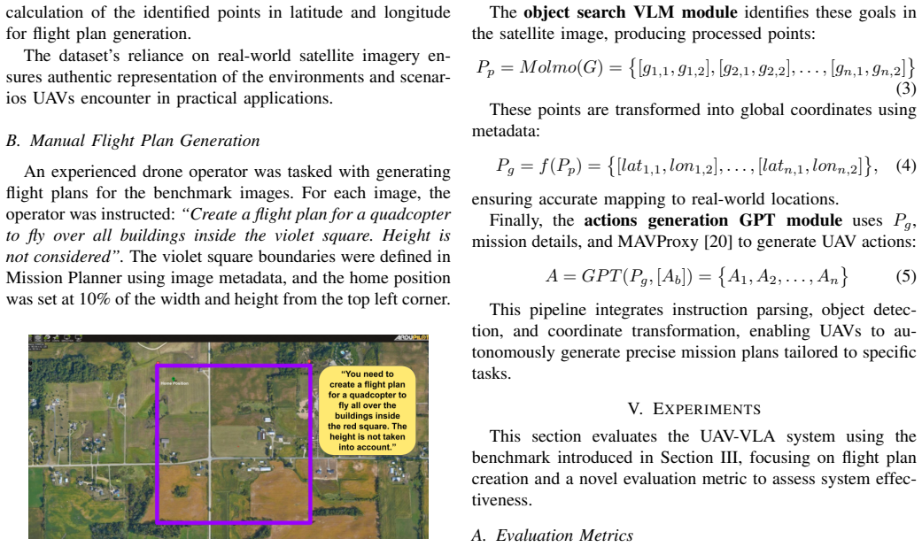
- [III-B and V-B] The ground-truth comparison is invalid as stated because the human operator and the system were given different missions. Section III-B instructs the operator to 'fly over all buildings inside the violet square' with 'Height is not considered', while Section V-B prompts the system to 'fly around each building at a height of 100 m, return to home, and land at the take-off point'. These differ in fly-over vs fly-around (changing waypoint placement), in the building set (violet-square constraint vs each building in the image), and in the return-to-home-and-land leg that is absent from the operator's instructions. Consequently, the 21.6% length overhead and the 34.22 m KNN error in Section VI may reflect prompt mismatch rather than planning quality. The authors must either use identical task instructions for both planners or explicitly control for these differences (e.g., by requiring both to perform the same return-home mission and restricting to the same building set).
- [V-A, Eq. (6)] The KNN error metric is one-sided and can be arbitrarily optimistic. The procedure matches each system point to its nearest ground-truth point, so a system that generates many points densely along the human path will have small KNN RMSE even if its route structure is very different (e.g., if it adds spurious out-and-back legs), and a system that generates fewer points than the human path will be penalized. The paper does not report the number of waypoints per trajectory for either planner. The authors should report waypoint counts, use a symmetric metric (e.g., bidirectional Hausdorff distance or average nearest-neighbor distance in both directions), and provide per-trajectory errors, not just aggregate means.
- [VI, Table I, Fig. 5] No uncertainty or repetition is reported. The pipeline uses stochastic language and vision models (GPT and Molmo), yet Table I and Fig. 5 report a single run. The human ground truth is also a single operator with no inter-operator variability measured. Without repeated runs (with different random seeds/temperatures) and multiple human annotators, the reader cannot determine whether a 21.6% length difference or a 34.22 m KNN error is statistically distinguishable from noise. The authors should report means and standard deviations over several runs and, at minimum, two or three independent human planners.
- [VI, Section III-B] The speed comparison is not controlled. The system processes 'all benchmark images in approximately 5 minutes 24 seconds', while the operator created plans for all 30 images in 35 minutes. However, the human task (fly over buildings inside a violet square, height not considered) is not the same as the system task (fly around each building at 100 m, return home, land), so the 6.5x speed advantage may be due to simpler instructions or shorter required path rather than to the system's efficiency. The timing should be measured on identical tasks, with the same output format, and with a timing breakdown that separates model inference from file I/O.
- [Abstract, Section VI] The abstract claims a 'mean error in finding the objects of interest on a map in 34.22 m', but the evaluation does not measure object detection accuracy. Table I's KNN RMSE is computed between system-generated trajectory points and human ground-truth trajectory points; it is not an object-level error. The system could miss buildings or hallucinate points and still achieve a small trajectory KNN error if the points lie near the path. The authors should evaluate building/object detection separately (e.g., precision and recall of detected objects against a labeled building set) or remove the object-finding claim from the abstract and conclusions.
minor comments (6)
- [Throughout] The benchmark name is inconsistent: 'UAV-VLPA-nano-30' appears in the contributions and Section III-A, while 'UAV-VLA-nano-30' appears in Section VI. Please standardize.
- [Throughout] There are many typographical issues, including 'UA V' missing spaces in the abstract and body text, 'sq. meters' instead of 'square meters', and 'K-Nearest Neighbors (KNN) approach' in the abstract.
- [III-A] The description 'Each image spans an area of roughly 760 sq. meters' with a resolution of 1.5 meters per pixel implies an image of about 22 by 22 pixels, which appears inconsistent with the satellite images shown in Fig. 2. Please clarify the units or the resolution.
- [IV, Eq. (6)] The variable n is used both for the number of goals in Eq. (2) and for the number of points in Eq. (6). Please use distinct symbols or define them explicitly.
- [IV] The actions generation module is described only as 'GPT(P_g, [A_b]) with MAVProxy'. The exact prompt format, the MAVProxy commands generated, and the output file format are not specified, making the work hard to reproduce from the paper alone.
- [Fig. 4] Figure 4 shows a human-made and a system-made plan, but there are no scale bars, coordinate axes, or building labels, so the reader cannot visually verify the reported 34.22 m KNN error.
Circularity Check
No circularity: the UAV-VLA flight plans and reported metrics are measured system outputs, not quantities reconstructed from the evaluation inputs.
full rationale
The paper's derivation chain is an implemented pipeline (text instruction -> GPT goal extraction -> Molmo object search on satellite imagery -> coordinate transformation -> GPT action generation), evaluated zero-shot against a human-generated benchmark. No parameter is fitted to the benchmark, and no reported metric (21.6% longer total path, KNN RMSE 34.22 m, DTW 307.27 m, sequential 409.54 m, or 5m24s runtime) is defined as a function of the system's inputs in a way that forces the outcome. The self-citations [2], [18], and [19] appear in related-work context and do not carry the central claim, so they are not load-bearing. The human-vs-system prompt mismatch ("fly over all buildings inside the violet square" vs "fly around each building at a height of 100 m, return to home, and land") is a legitimate evaluation-validity concern, but it is not circularity: the system's outputs are not equivalent to the ground truth by construction, and no equation reduces one to the other. Therefore the paper shows no significant circularity.
Assumptions & free parameters
assumptions (4)
- domain assumption The VLM (Molmo) can reliably identify objects of interest in satellite imagery.
- domain assumption GPT can generate valid waypoint sequences and MAVProxy commands from the coordinates.
- domain assumption The satellite metadata maps pixel coordinates to global coordinates accurately.
- domain assumption The human operator's flight plan is a valid ground truth.
Cite this review
Pith. "Pith review of UAV-VLA: Vision-Language-Action System for Large Scale Aerial Mission Generation." pith.science (2026). https://pith.science/paper/UWPOOVFH
@misc{pith2026250105014,
  author       = {Pith},
  title        = {Pith review of: UAV-VLA: Vision-Language-Action System for Large Scale Aerial Mission Generation},
  year         = {2026},
  howpublished = {\url{https://pith.science/paper/UWPOOVFH}},
  note         = {Machine review of arXiv:2501.05014}
}
read the original abstract
The UAV-VLA (Visual-Language-Action) system is a tool designed to facilitate communication with aerial robots. By integrating satellite imagery processing with the Visual Language Model (VLM) and the powerful capabilities of GPT, UAV-VLA enables users to generate general flight paths-and-action plans through simple text requests. This system leverages the rich contextual information provided by satellite images, allowing for enhanced decision-making and mission planning. The combination of visual analysis by VLM and natural language processing by GPT can provide the user with the path-and-action set, making aerial operations more efficient and accessible. The newly developed method showed the difference in the length of the created trajectory in 22% and the mean error in finding the objects of interest on a map in 34.22 m by Euclidean distance in the K-Nearest Neighbors (KNN) approach.
Figures


Figures from the paper (3 more)


Forward citations
Cited by 2 Pith papers
-
AERMANI-VLM: Structured Prompting and Reasoning for Aerial Manipulation with Vision Language Models
Structured prompting plus a discrete skill library lets a frozen VLM direct aerial manipulation, reaching 87.5% simulated and 80% hardware success in pick-and-place tasks.
-
When Large Language Models Meet UAV Projects: An Empirical Study from Developers' Perspective
The first empirical taxonomy of LLM tasks in UAVs, with an academia-industry comparison and survey, shows LLMs are used mainly for planning and interaction, not direct control.
Reference graph
Works this paper leans on
-
[1]
AI meets UA Vs: A survey on AI empowered UA V perception systems for precision agriculture,
J. Su, X. Zhu, S. Li, and W.-H. Chen, “AI meets UA Vs: A survey on AI empowered UA V perception systems for precision agriculture,” Neurocomputing, vol. 518, pp. 242–270, 2023
work page 2023
-
[2]
O. Sautenkov, S. Asfaw, Y . Yaqoot, M. A. Mustafa, A. Fedoseev, D. Trinitatova, and D. Tsetserukou, “FlightAR: AR Flight Assistance Interface with Multiple Video Streams and Object Detection Aimed at Immersive Drone Control,” arXiv preprint arXiv:2410.16943 , 2024
-
[3]
A. Vaswani, N. Shazeer, N. Parmar, J. Uszkoreit, L. Jones, A. N. Gomez, L. Kaiser, and I. Polosukhin, “Attention Is All You Need,”arXiv preprint arXiv:1706.03762, 2023
arXiv 2023
-
[4]
OpenVLA: An Open-Source Vision-Language-Action Model,
M. J. Kim, K. Pertsch, S. Karamcheti, T. Xiao, A. Balakrishna, S. Nair, R. Rafailov, E. Foster, G. Lam, P. Sanketi, Q. Vuong, T. Kollar, B. Burchfiel, R. Tedrake, D. Sadigh, S. Levine, P. Liang, and C. Finn, “OpenVLA: An Open-Source Vision-Language-Action Model,” arXiv preprint arXiv:2406.09246, 2024
arXiv 2024
-
[5]
RT-1: Robotics Transformer for Real-World Control at Scale,
A. Brohan et al., “RT-1: Robotics Transformer for Real-World Control at Scale,” arXiv preprint arXiv:2212.06817 , 2023
arXiv 2023
-
[6]
RT-2: Vision-Language-Action Mod- els Transfer Web Knowledge to Robotic Control,
A. Brohan, N. Brown et al. , “RT-2: Vision-Language-Action Mod- els Transfer Web Knowledge to Robotic Control,” arXiv preprint arXiv:2307.15818, 2023
arXiv 2023
-
[7]
CityNav: Language-Goal Aerial Navigation Dataset with Geographic Information,
J. Lee, T. Miyanishi, S. Kurita, K. Sakamoto, D. Azuma, Y . Matsuo, and N. Inoue, “CityNav: Language-Goal Aerial Navigation Dataset with Geographic Information,” arXiv preprint arXiv:2406.14240 , 2024
arXiv 2024
-
[8]
J. Zhong, M. Li, Y . Chen, Z. Wei, F. Yang, and H. Shen, “A Safer Vision- based Autonomous Planning System for Quadrotor UA Vs with Dynamic Obstacle Trajectory Prediction and Its Application with LLMs,” arXiv preprint arXiv:2311.12893, 2023
work page Pith review arXiv 2023
Show all 22 references
-
[9]
Aerial Vision-and-Dialog Navigation,
Y . Fan, W. Chen, T. Jiang, C. Zhou, Y . Zhang, and X. E. Wang, “Aerial Vision-and-Dialog Navigation,” arXiv preprint arXiv:2205.12219, 2023
2023 arXiv
-
[10]
Embodied- City: Embodied Aerial Agent for City-level Visual Language Navigation Using Large Language Model,
W. Zhang, Y . Liu, X. Wang, X. Chen, C. Gao, and X. Chen, “Embodied- City: Embodied Aerial Agent for City-level Visual Language Navigation Using Large Language Model,” in 2024 23rd ACM/IEEE International Conference on Information Processing in Sensor Networks (IPSN), 2024, pp. 265–266
2024
-
[11]
An Image is Worth 16x16 Words: Transformers for Image Recognition at Scale,
A. Dosovitskiy, L. Beyer, A. Kolesnikov, D. Weissenborn, X. Zhai, T. Unterthiner, M. Dehghani, M. Minderer, G. Heigold, S. Gelly, J. Uszkoreit, and N. Houlsby, “An Image is Worth 16x16 Words: Transformers for Image Recognition at Scale,” arXiv preprint arXiv:2010.11929, 2021
2010 arXiv
-
[12]
Learning Transferable Visual Models from Natural Language Supervi- sion,
A. Radford, J. W. Kim, C. Hallacy, A. Ramesh, G. Goh, S. Agarwal, G. Sastry, A. Askell, P. Mishkin, J. Clark, G. Krueger, and I. Sutskever, “Learning Transferable Visual Models from Natural Language Supervi- sion,” arXiv preprint arXiv:2103.00020 , 2021
2021 arXiv
-
[13]
GPT-4 Technical Report,
OpenAI et al. , “GPT-4 Technical Report,” arXiv preprint arXiv:2303.08774, 2024
2024 arXiv
-
[14]
Molmo and PixMo: Open Weights and Open Data for State-of-the-Art Multimodal Models,
M. Deitke et al., “Molmo and PixMo: Open Weights and Open Data for State-of-the-Art Multimodal Models,” arXiv preprint arXiv:2409.17146, 2024
2024 arXiv
-
[15]
Aeri- alVLN: Vision-and-Language Navigation for UA Vs,
S. Liu, H. Zhang, Y . Qi, P. Wang, Y . Zhang, and Q. Wu, “Aeri- alVLN: Vision-and-Language Navigation for UA Vs,” arXiv preprint arXiv:2308.06735, 2023
2023 arXiv
-
[16]
Aerial Vision-and-Language Navigation via Semantic-Topo-Metric Representa- tion Guided LLM Reasoning,
Y . Gao, Z. Wang, L. Jing, D. Wang, X. Li, and B. Zhao, “Aerial Vision-and-Language Navigation via Semantic-Topo-Metric Representa- tion Guided LLM Reasoning,” arXiv preprint arXiv:2410.08500 , 2024
2024 arXiv
-
[17]
Towards Realistic UA V Vision-Language Navigation: Plat- form, Benchmark, and Methodology,
X. Wang, D. Yang, Z. Wang, H. Kwan, J. Chen, W. Wu, H. Li, Y . Liao, and S. Liu, “Towards Realistic UA V Vision-Language Navigation: Plat- form, Benchmark, and Methodology,” arXiv preprint arXiv:2410.07087, 2024
2024 arXiv
-
[18]
Bi-VLA: Vision-Language-Action Model-Based System for Bimanual Robotic Dexterous Manipulations,
K. F. Gbagbe, M. A. Cabrera, A. Alabbas, O. Alyunes, A. Lykov, and D. Tsetserukou, “Bi-VLA: Vision-Language-Action Model-Based System for Bimanual Robotic Dexterous Manipulations,” arXiv preprint arXiv:2405.06039, 2024
2024 arXiv
-
[19]
MissionGPT: Mission Planner for Mobile Robot based on Robotics Transformer Model,
V . Berman, A. Bazhenov, and D. Tsetserukou, “MissionGPT: Mission Planner for Mobile Robot based on Robotics Transformer Model,” arXiv preprint arXiv:2411.05107, 2024
2024 arXiv
-
[20]
[Online]
Mavproxy Cheatsheet , 2024. [Online]. Available: https://ardupilot.org/ mavproxy/docs/getting started/cheatsheet.html
2024
-
[21]
M ¨uller, Information Retrieval for Music and Motion
M. M ¨uller, Information Retrieval for Music and Motion. Springer Berlin Heidelberg, 2007, ch. 4, pp. 69–84
2007
-
[22]
[Online]
Molmo-7B-D BnB 4bit quantized 7GB , 2024. [Online]. Available: https://huggingface.co/cyan2k/molmo-7B-D-bnb-4bit
2024
Reviewed August 10, 2026 · model on record in the stance chip above.
Discussion (0). Continue with ORCID to comment.