REVIEW 3 major objections 6 minor 48 references
Very High-Resolution Forest Mapping with TanDEM-X InSAR Data and Self-Supervised Learning
T0 review · 3 major / 6 minor · reviewed 2026-08-15 · deepseek-v4-flash
Pith's one-line read The paper claims that inpainting-based self-supervised pretraining on unlabeled TanDEM-X data lets a U-Net map forests at 6 m with only 1.5% of the labels, nearly matching fully supervised performance, and raises Amazon agreement with a…
desk verdict The Pennsylvania experiments support the claim that masked-inpainting pretraining helps low-label 6 m forest mapping; the Amazon half of the paper relies on agreement with an optical land-cover map rather than independent high-resolution labels, so the tropical headline is not yet established. read the letter →
The pith
A machine-rendered reading of the paper's core claim, the machinery that carries it, and where it could break.
The reading
What carries the argument
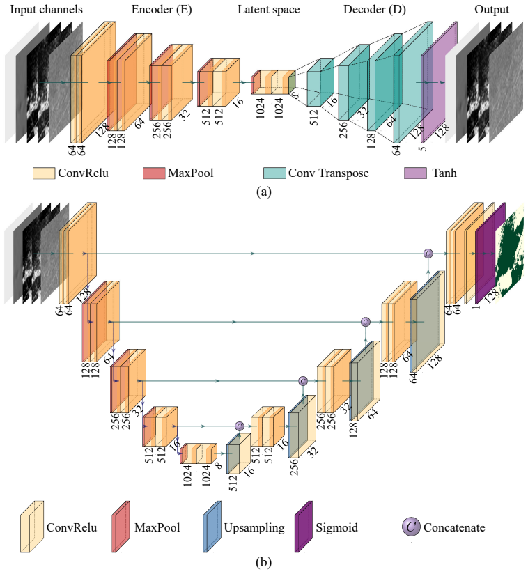
The load-bearing object is a masked convolutional autoencoder trained with an inpainting loss: a 64×64 block is deleted from each 128×128 patch, and the network predicts the missing block while 99% of the reconstruction loss weight falls on the masked area. Its encoder, once trained, initializes the encoder of a U-Net, and both encoder and decoder are then fine-tuned on the small labeled set. Five TanDEM-X channels feed the network: calibrated backscatter, total coherence, volume correlation factor, local incidence angle, and height of ambiguity, with coherence estimated at 6 m using a residual deep network. The inpainting mask is what distinguishes useful representations from identity reconstruction: it compels the encoder to learn spatial context and scene structure instead of simply copying the input.
What would settle it
Evaluate SSL-In E+D on a held-out set of LiDAR-based forest/non-forest labels over the Amazon mapped area, at the same 6 m resolution, and compare its overall accuracy and forest F1 with the fully supervised model; if the margin over FSL disappears against independent labels, then the 0.74 accuracy is agreement with the CCI product rather than true accuracy.
Extended reading notes
Core claim
The central claim is that inpainting-based self-supervised pretraining substantially closes the label gap in 6 m forest mapping with TanDEM-X interferometric SAR. On the Pennsylvania test region, the SSL-In E+D model, whose encoder is pretrained by masking a 64×64 pixel block in each 128×128 patch and then fine-tuning both encoder and decoder, achieves weighted F1 scores close to a fully supervised baseline when trained with only 1.5% of the labels. Over the Amazon, with only 15 LiDAR-derived forest/non-forest patches, SSL-In E+D raises overall accuracy from 0.65 to 0.74 and forest F1 from 0.62 to 0.77 relative to the 10 m CCI reference map, while identity reconstruction gives no consistent benefit. The paper attributes the gain to the pretext task forcing the encoder to use spatial context to infer missing structure, producing transferable representations of forest texture and edges.
Load-bearing premise
The Amazon result is measured against the 10 m CCI optical map as the reference, and the Pennsylvania ground truth is a 1 m map from 2010 compared with 2011-2012 acquisitions; if those references are inaccurate, temporally mismatched, or define forest by a different height threshold, the reported gains overstate true forest-mapping accuracy.
Editorial extensions
If this is right
- At 6 m, inpainting-pretrained models can deliver forest/non-forest maps from TanDEM-X that are close to a fully supervised model's quality using 1.5% of the labels over Pennsylvania.
- Identity reconstruction is not a useful pretext for this task; the gain comes from masking, so SSL recipes for InSAR should emphasize destructively reconstructing input rather than reproducing it.
- Pretraining on unlabeled data with varied acquisition geometries improves robustness: the SSL model outperforms the supervised baseline on a 2013 descending-orbit test image, suggesting better generalization to unseen geometries.
- With only a few LiDAR patches in the Amazon, the SSL approach lifts agreement with the 10 m CCI forest map from 0.65 to 0.74 overall accuracy and improves detection of narrow roads and small clear-cuts in dense forest.
- The same framework can be applied to new regions by retraining the downstream U-Net with limited local labels, since the pretext stage uses only unlabeled TanDEM-X data.
Reading between the lines
- If the Amazon result survives comparison with independent high-resolution labels, the inpainting pretext could become a general pretraining step for other InSAR mapping tasks such as canopy height, deforestation, or flood mapping, because the unsupervised stage only needs raw acquisitions.
- Part of the reported Amazon gain may reflect alignment with the 10 m CCI map's forest definition and pixel grid rather than absolute accuracy; holding out LiDAR-derived patches as a test set would tell which.
- The experimental design mixes two variables, the pretext task and the geometry balance of the unlabeled set; a controlled ablation that randomizes the height-of-ambiguity distribution in the SSL data would separate the pretraining effect from the benefit of seeing diverse geometries.
- Since classification errors concentrate on forest/non-forest borders, a natural testable extension is multi-scale or multiple masks in the inpainting task to see whether edge delineation, rather than global forest detection, improves further.
Signed reviews
Editorial analysis
A structured set of objections, weighed in public.
Referee Report
Summary. The paper investigates self-supervised learning (SSL) for forest/non-forest mapping at 6 m resolution using TanDEM-X bistatic InSAR features (backscatter, coherence, volume correlation factor, incidence angle, height of ambiguity). Two pretext tasks are compared, identity reconstruction and masked inpainting, with a convolutional autoencoder, followed by transferring encoder weights to a U-Net for the downstream forest-mapping task. Experiments over Pennsylvania compare fully supervised learning (FSL) with several SSL variants at 1.5%, 8%, and 22% of the available labels, and the authors report that the best SSL variant (SSL-In E+D) with 1.5% labels performs close to the 100%-label baseline. The same approach is then applied to the Amazon rainforest, where the authors report an improvement in overall accuracy from 0.65 to 0.74 relative to a fully supervised baseline when both are compared against the ESA CCI HRLC 10 m optical land-cover map.
Significance. If the reported results hold, the paper makes a useful contribution by demonstrating that inpainting-based self-supervised pre-training on unlabeled TanDEM-X data can substantially reduce the dependence on high-resolution reference labels for very-high-resolution forest mapping. The Pennsylvania experiments are carefully designed: test subsets are stratified by height of ambiguity and orbit direction, test images are excluded from all learning tasks, and three runs per configuration are averaged. The paper also benefits from a physically meaningful input feature set and a clear comparison against a fully supervised baseline. The main limitation is that the Amazon evaluation, which carries the large-scale tropical application claim, is performed against an optical land-cover product rather than independent high-resolution forest labels, leaving the central claim partly unsupported.
major comments (3)
- [Section 4.2, Table 4] The Amazon accuracy figures in Table 4 are computed by comparing the TanDEM-X-derived maps with the ESA HRLC 10 m optical map described in Section 2.4, not with the LiDAR-based forest/non-forest reference introduced in Section 2.3. HRLC is a 2019 optical land-cover product with 15 classes; collapsing tree-cover classes to forest and all other classes to non-forest introduces a definitional and sensor-specific disagreement that is not equivalent to an error assessment against high-resolution forest labels. The reported gain from 0.65 to 0.74 could therefore reflect better agreement with HRLC's particular biases rather than a genuine improvement in forest-mapping accuracy. To support the central claim, the authors should validate on independent high-resolution reference data, for example by holding out a subset of the LiDAR patches described in Section 2.3, or by comparing against an independent high-resolution forest product.
- [Section 4.1 and Section 3.5] The best SSL variant is selected on the Pennsylvania test region before being applied to the Amazon ('We select the best performing model in each case for the further classification', Section 4.1). Since the Pennsylvania test subsets are the same data used for model selection, the reported Fw1 improvements for SSL-In E+D over FSL (e.g., Table A.5) are not unbiased estimates; selection on the test set can inflate the apparent gain. In addition, the three runs are averaged without significance testing, and differences as small as 0.01-0.02 Fw1 (e.g., Table A.5, short hamb: FSL 0.8957 vs SSL-In E+D 0.9065) may be within run-to-run variability. The authors should use a separate validation partition for model selection or report confidence intervals and pairwise significance tests.
- [Section 2.3 and Section 2.4] There is a temporal mismatch between the reference data and the evaluation data. The Pennsylvania reference map is from 2010 (Section 2.2) while the test acquisitions are from 2011-2013 (Table 1), and the Amazon LiDAR patches span 2012-2018 (Section 2.3) while the evaluation images are from 2019-2020 (Section 2.1). Over the Amazon, deforestation between the reference date and the evaluation date is an uncontrolled confounder: a pixel mapped as forest in 2013 may legitimately be non-forest in 2019, so agreement with the 2019 HRLC map is not a clean measure of classification accuracy. The paper should either restrict evaluation to areas known to be stable (e.g., using a deforestation mask) or explicitly quantify the potential impact of the temporal mismatch.
minor comments (6)
- [Section 3.2.2, Eqs. (6)-(8)] The notation for the masked input is inconsistent between Eq. (6), where \hat{x} = M \odot x, and Eq. (8), where the input is written as (1-M) \odot x. Please define the masked input once and use it consistently in the loss terms.
- [Section 3.5] The sentence 'The presented results correspond to the average obtained after the corresponding runs of each combination of the Fw1-score values' is incomplete or grammatically unclear. Please revise it to describe explicitly what is averaged and over which runs.
- [Table 4] Table 4 reports accuracy and F1 scores without any measure of variability. Given that three runs are available for the Pennsylvania experiments, it would be informative to report standard deviations or confidence intervals for the Amazon results as well, especially for the non-forest F1 values that are based on a subset of images.
- [References] The reference to Hansen et al. (2013) contains a typographical error in the author list: 'Stehamn' should be 'Stehman'.
- [Appendix A, Table A.3] In Table A.3, the SSL-Id D row for the short hamb subset shows '0.89012' without a space; this appears to be a formatting error that should be corrected.
- [Section 2.2] The phrase 'we scale the original resolution down to 6 m' is more precisely described as 'we resample the 1 m map to 6 m pixel size'; 'scaling down' is ambiguous about the aggregation method.
Circularity Check
No significant circularity: the SSL-vs-FSL comparison is an empirical benchmark against external reference maps; the claimed gains are not forced by construction.
full rationale
The paper's central claim is an empirical comparison between training protocols: a fully-supervised U-Net (FSL) versus a U-Net initialized with a self-supervised inpainting autoencoder (SSL-In E+D), both trained with the same reduced label fractions and evaluated on held-out TanDEM-X acquisitions. The SSL pretext task is fit to unlabeled input features only, and the downstream task is fit to reference labels; no equation in the paper defines the reported accuracy in terms of the model's own inputs. The input features (backscatter, coherence, volume correlation factor, incidence angle, height of ambiguity) are externally derived radar quantities, and the reference maps for Pennsylvania and the Amazon are external products (LiDAR/optical map and ESA CCI HRLC), not outputs of the proposed model. The Amazon comparison against the ESA CCI HRLC map is an evaluation choice, with the known weakness that HRLC is an optical 10 m product rather than independent high-resolution labels; this is a correctness and validation-quality concern, not a circularity, because the HRLC map is not used as a training target and the reported accuracy is not algebraically forced by the model construction. The paper does cite prior work from the same research group for feature definitions (e.g., volume correlation factor, Phi-Net coherence estimation) and for earlier U-Net forest mapping, but these citations supply independent methodological inputs rather than the paper's conclusion, and no load-bearing argument reduces to a self-citation. Model selection on the Pennsylvania test region is a methodological overfitting risk, not a circular derivation. Overall, the derivation chain is self-contained with respect to the stated experiments, and the claimed improvements are empirical findings rather than tautological predictions.
Assumptions & free parameters
free parameters (4)
- Amazon forest/non-forest CHM threshold =
4 m
- Inpainting mask size =
64 x 64 pixels, random location in 128 x 128 patch
- Inpainting loss weight wrec =
0.99
- Non-forest evaluation thresholds =
5% and 10% non-forest pixels per image
assumptions (4)
- domain assumption Total interferometric coherence factorizes into independent decorrelation terms with no temporal decorrelation for single-pass TanDEM-X (gamma_Temp = 1).
- domain assumption Pennsylvania reference map (vegetation higher than 2 m, from 2010 LiDAR/optical) is an accurate forest/non-forest label at 6 m after downsampling.
- domain assumption ESA CCI HRLC 10 m map is a suitable reference for evaluating TanDEM-X forest/non-forest classifications resampled to 10 m.
- domain assumption Averaging three training runs is sufficient to estimate performance without significance testing.
Cite this review
Pith. "Pith review of Very High-Resolution Forest Mapping with TanDEM-X InSAR Data and Self-Supervised Learning." pith.science (2026). https://pith.science/paper/76J5HT2B
@misc{pith2026250503327,
  author       = {Pith},
  title        = {Pith review of: Very High-Resolution Forest Mapping with TanDEM-X InSAR Data and Self-Supervised Learning},
  year         = {2026},
  howpublished = {\url{https://pith.science/paper/76J5HT2B}},
  note         = {Machine review of arXiv:2505.03327}
}
read the original abstract
Deep learning models have shown encouraging capabilities for mapping accurately forests at medium resolution with TanDEM-X interferometric SAR data. Such models, as most of current state-of-the-art deep learning techniques in remote sensing, are trained in a fully-supervised way, which requires a large amount of labeled data for training and validation. In this work, our aim is to exploit the high-resolution capabilities of the TanDEM-X mission to map forests at 6 m. The goal is to overcome the intrinsic limitations posed by midresolution products, which affect, e.g., the detection of narrow roads within vegetated areas and the precise delineation of forested regions contours. To cope with the lack of extended reliable reference datasets at such a high resolution, we investigate self-supervised learning techniques for extracting highly informative representations from the input features, followed by a supervised training step with a significantly smaller number of reliable labels. A 1 m resolution forest/non-forest reference map over Pennsylvania, USA, allows for comparing different training approaches for the development of an effective forest mapping framework with limited labeled samples. We select the best-performing approach over this test region and apply it in a real-case forest mapping scenario over the Amazon rainforest, where only very few labeled data at high resolution are available. In this challenging scenario, the proposed self-supervised framework significantly enhances the classification accuracy with respect to fully-supervised methods, trained using the same amount of labeled data, representing an extremely promising starting point for large-scale, very high-resolution forest mapping with TanDEM-X data.
Figures


Figures from the paper (6 more)


Reference graph
Works this paper leans on
-
[1]
author Bruzzone, L. , author Bovolo, F. , author Amodio, A. , author Brovelli, M. , author Corsi, M. , author Defourny, P. , author Domingo, C. , author Gamba, P. , author Kolitzus, D. , author Lamarche, C. , author Moser, G. , author Ottlé, C. , author Perantoni, G. , author Pesquer, L. , author Zanetti, M. , year 2024 . title ESA High Resolution Land Co...
work page 2024
-
[2]
author Bueso-Bello, J.L. , author Carcereri, D. , author Martone, M. , author Gonzalez, C. , author Posovszky, P. , author Rizzoli, P. , year 2022 . title Deep learning for mapping tropical forests with TanDEM-X bistatic InSAR data . journal Remote Sensing volume 14
work page 2022
-
[3]
author Carcereri, D. , author Rizzoli, P. , author Dell’Amore, L. , author Bueso-Bello, J.L. , author Ienco, D. , author Bruzzone, L. , year 2024 . title Generation of country-scale canopy height maps over Gabon using deep learning and TanDEM-X InSAR data . journal Remote Sensing of Environment volume 311 , pages 114270 . https://www.sciencedirect.com/sci...
arXiv 2024
-
[4]
author Carcereri, D. , author Rizzoli, P. , author Ienco, D. , author Bruzzone, L. , year 2023 . title A deep learning framework for the estimation of forest height from bistatic TanDEM-X data . journal IEEE Journal of Selected Topics in Applied Earth Observations and Remote Sensing volume 16 , pages 8334--8352 . :10.1109/JSTARS.2023.3310209
arXiv 2023
-
[5]
author Chazdon, R.L. , author Brancalion, P.H. , author Laestadius, L. , author Bennett-Curry, A. , author Buckingham, K. , author Kumar, C. , author Moll-Rocek, J. , author Vieira, I. , author Wilson, S. , year 2016 . title When is a forest a forest? Forest concepts and definitions in the era of forest and landscape restoration . journal Ambio volume 45 ...
-
[6]
author Dal Molin, R. , author Rizzoli, P. , year 2022 . title Potential of convolutional neural networks for forest mapping using Sentinel-1 interferometric short time series . journal Remote Sensing volume 14 . https://www.mdpi.com/2072-4292/14/6/1381, :10.3390/rs14061381
-
[7]
author Diniz, F. , author Kok, K. , author Hott, M. , author Hoogstra-Klein, M. , author Arts, B. , year 2013 . title From space and from the ground: Determining forest dynamics in settlement projects in the Brazilian Amazon . journal International Forestry Review volume 15 , pages 442--455 . :10.1505/146554813809025658
-
[8]
author Dos-Santos, M. , author Keller, M. , author Morton, D. , year 2019 . title LiDAR surveys over selected forest research sites, Brazilian Amazon, 2008-2018 . https://daac.ornl.gov/cgi-bin/dsviewer.pl?ds_id=1644, :10.3334/ORNLDAAC/1644
Show all 48 references
-
[9]
title Global Forest Resources Assessment 2020
author FAO , year 2020 . title Global Forest Resources Assessment 2020 . publisher FAO . http://www.fao.org/documents/card/en/c/ca9825en, :10.4060/ca9825en
2020 doi
-
[10]
, author White, J
author Fassnacht, F. , author White, J. , author Wulder, M. , author Næsset, E. , year 2023 . title Remote sensing in forestry: current challenges, considerations and directions . journal Forestry: An International Journal of Forest Research volume 97 , pages 11--37 . :10.1093...
2023 doi
-
[11]
, author Breit, H
author Fritz, T. , author Breit, H. , author Rossi, C. , author Balss, U. , author Lachaise, M. , author Duque, S. , year 2012 . title Interferometric processing and products of the TanDEM - X mission , in: booktitle 2012 IEEE International Geoscience and Remote Sensing Sympos...
2012
-
[12]
, author Ebel, P
author Gawlikowski, J. , author Ebel, P. , author Schmitt, M. , author Zhu, X.X. , year 2022 . title Explaining the effects of clouds on remote sensing scene classification . journal IEEE Journal of Selected Topics in Applied Earth Observations and Remote Sensing volume 15 , p...
2022
-
[13]
, author Liu, H
author Gong, P. , author Liu, H. , author Zhang, M. , author Li, C. , author Wang, J. , author Huang, H. , author Clinton, N. , author Ji, L. , author Li, W. , author Bai, Y. , author Chen, B. , author Xu, B. , author Zhu, Z. , author Yuan, C. , author Ping Suen , H. , author ...
2019
-
[14]
, author Bachmann, M
author Gonzalez, C. , author Bachmann, M. , author Bueso-Bello, J.L. , author Rizzoli, P. , author Zink, M. , year 2020 . title A fully automatic algorithm for editing the TanDEM-X global DEM . journal Remote Sensing volume 12 , pages 3961 . https://www.mdpi.com/2072-4292/12/2...
2020 doi
-
[15]
, author Rizzoli, P
author Gonzalez, C. , author Rizzoli, P. , year 2018 . title Landcover-dependent assessment of the relative height accuracy in T an DEM-X DEM products . journal IEEE Geoscience Remote Sensing Letters volume 15 , pages 1892--1896
2018
-
[16]
, author Mitchard, E
author Hansen, J. , author Mitchard, E. , author King, S. , year 2020 . title Assessing forest/non-forest separability using Sentinel-1 C -band synthetic aperture radar . journal Remote Sensing volume 12 . https://www.mdpi.com/2072-4292/12/11/1899, :10.3390/rs12111899
2020 doi
-
[17]
, author Potapov, P.V
author Hansen, M.C. , author Potapov, P.V. , author Moore, R. , author Hancher, M. , author Turubanova, S.A. , author Tyukavina, A. , author Thau, D. , author Stehamn, S.V. , author Goetz, S.J. , author Loveland, T.R. , author Kommareddy, J.R.G. , year 2013 . title High-resolu...
2013
-
[18]
, year 2020
author Jadon, S. , year 2020 . title A survey of loss functions for semantic segmentation . journal IEEE Conference on Computational Intelligence in Bioinformatics and Computational Biology (CIBCB) , pages 1--7
2020
-
[19]
, author Moreira, A
author Krieger, G. , author Moreira, A. , author Fiedler, H. , author Hajnsek, I. , author Werner, M. , author Younis, M. , author Zink, M. , year 2007 . title Tan DEM-X : A satellite formation for high-resolution SAR interferometry . journal IEEE Transactions on Geoscience an...
2007
-
[20]
, author Liu, Y
author Ma, L. , author Liu, Y. , author Zhang, X. , author Ye, Y. , author Yin, G. , author Johnson, B. , year 2019 . title Deep learning in remote sensing applications: A meta-analysis and review . journal ISPRS Journal of Photogrammetry and Remote Sensing volume 152 , pages 166--177
2019
-
[21]
, author Br\" a utigam, B
author Martone, M. , author Br\" a utigam, B. , author Rizzoli, P. , author Gonzalez, C. , author Bachmann, M. , author Krieger, G. , year 2012 . title Coherence evaluation of TanDEM-X interferometric data . journal ISPRS Journal of Photogrammetry and Remote Sensing volume 73 ...
2012
-
[22]
, author Rizzoli, P
author Martone, M. , author Rizzoli, P. , author Krieger, G. , year 2016 . title Volume decorrelation effects in T an DEM-X interferometric SAR data . journal IEEE Geoscience and Remote Sensing Letters volume 13 , pages 1812--1816
2016
-
[23]
, author Rizzoli, P
author Martone, M. , author Rizzoli, P. , author Wecklich, C. , author Gonzalez, C. , author Bueso-Bello, J.L. , author Valdo, P. , author Schulze, D. , author Zink, M. , author Krieger, G. , author Moreira, A. , year 2018 a. title The global forest/non-forest map from TanDEM-...
2018
-
[24]
, author Sica, F
author Martone, M. , author Sica, F. , author Gonzalez, C. , author Bueso-Bello, J.L. , author Valdo, P. , author Rizzoli, P. , year 2018 b. title High-resolution forest mapping from TanDEM-X interferometric data exploiting nonlocal filtering . journal Remote Sensing volume 10...
2018
-
[25]
, author Sica, F
author Mazza, A. , author Sica, F. , author Rizzoli, P. , author Scarpa, G. , year 2019 . title TanDEM-X forest mapping using convolutional neural networks . journal Remote Sensing volume 11
2019
-
[26]
, author MacFaden, S
author O’Neil-Dunne, J. , author MacFaden, S. , author Royar, A. , author Reis, M. , author Dubayah, R. , author Swatantran, A. , year 2014 . title An object-based approach to statewide land cover mapping , in: booktitle Proceedings of ASPRS 2014 annual conference , pp. pages 23--28
2014
-
[27]
, author Gross, S
author Paszke, A. , author Gross, S. , author Massa, F. , author Lerer, A. , author Bradbury, J. , author Chanan, G. , author Killeen, T. , author Lin, Z. , author Gimelshein, N. , author Antiga, L. , author Desmaison, A. , author K \" o pf, A. , author Yang, E. , author DeVit...
2019
-
[28]
a henb \
author Pathak, D. , author Kr \" a henb \" u hl, P. , author Donahue, J. , author Darrell, T. , author Efros, A. , year 2016 . title Context encoders: Feature learning by inpainting . journal CoRR http://arxiv.org/abs/1604.07379
2016 arXiv
-
[29]
, author Prats-Iraola, P
author Pulella, A. , author Prats-Iraola, P. , author Sica, F. , year 2024 . title Multitask learning for phase source separation in InSAR burst modes . journal IEEE Transactions on Geoscience and Remote Sensing volume 62 , pages 1--21 . :10.1109/TGRS.2024.3401775
2024
-
[30]
, author Dell'Amore, L
author Rizzoli, P. , author Dell'Amore, L. , author Bueso-Bello, J.L. , author Gollin, N. , author Carcereri, D. , author Martone, M. , year 2022 . title On the derivation of volume decorrelation from TanDEM-X bistatic coherence . journal IEEE Journal of Selected Topics in App...
2022
-
[31]
, author Martone, M
author Rizzoli, P. , author Martone, M. , author Gonzalez, C. , author Wecklich, C. , author Br\" a utigam, B. , author Borla Tridon, D. , author Bachmann, M. , author Schulze, D. , author Fritz, T. , author Huber, M. , author Wessel, B. , author Krieger, G. , author Zink, M. ...
2017
-
[32]
, author Fischer, P
author Ronneberger, O. , author Fischer, P. , author Brox, T. , year 2015 . title U-Net : Convolutional networks for biomedical image segmentation
2015
-
[33]
, author Moltchanova, E
author Schepaschenko, D. , author Moltchanova, E. , author Fedorov, S. , author Karminov, V. , author Ontikov, P. , author Santoro, M. , author See, L. , author Kositsyn, V. , author Shvidenko, A. , author Romanovskaya, A. , author Korotkov, V. , author Lesiv, M. , author Bart...
2021
-
[34]
, author von Poncet, F
author Schlund, M. , author von Poncet, F. , author Hoekman, D. , author Kuntz, S. , author Schmullius, C. , year 2014 . title Importance of bistatic SAR features from TanDEM-X for forest mapping and monitoring . journal Remote Sensing of Environment volume 151 , pages 16--26 ...
2014
-
[35]
, author Itoh, T
author Shimada, M. , author Itoh, T. , author Motooka, T. , author Watanabe, M. , author Shiraishi, T. , author Thapa, R. , author Lucas, R. , year 2014 . title New global forest/non-forest maps from ALOS PALSAR data (2007-2010) . journal Remote Sensing of Environment volume 1...
2014
-
[36]
, author Calvanese, F
author Sica, F. , author Calvanese, F. , author Scarpa, G. , author Rizzoli, P. , year 2022 . title A coherence-driven approach for I n SAR phase unwrapping using convolutional neural network . journal IEEE Geoscience and Remote Sensing Letters volume 19 , pages 1--5
2022
-
[37]
, author Gobbi, G
author Sica, F. , author Gobbi, G. , author Rizzoli, P. , author Bruzzone, L. , year 2020 . title -net: Deep residual learning for InSAR parameters estimation . journal IEEE Transactions on Geoscience and Remote Sensing volume PP . :10.1109/TGRS.2020.3020427
2020
-
[38]
, author Batra, A
author Singh, S. , author Batra, A. , author Pang, G. , author Torresani, L. , author Basu, S. , author Paluri, M. , author Jawahar, C. , year 2018 . title Self-supervised feature learning for semantic segmentation of overhead imagery , in: booktitle British Machine Vision Con...
2018
-
[39]
, author Li, W
author Sudre, C. , author Li, W. , author Vercauteren, T. , author Ourselin, S. , author Cardoso, M. , year 2017 . title Generalised dice overlap as a deep learning loss function for highly unbalanced segmentations , in: booktitle Deep Learning in Medical Image Analysis and Mu...
2017
-
[40]
, year 1971
author Townsend, J. , year 1971 . title Theoretical analysis of an alphabetic confusion matrix . journal Perception & Psychophysics volume 9 , pages 40--50
1971
-
[41]
title United Nations Climate Change, Annual Report 2020
author UNFCCC , year 2020 . title United Nations Climate Change, Annual Report 2020 . publisher United Nations Framework Convention on Climate Change
2020
-
[42]
, author Albrecht, C
author Wang, Y. , author Albrecht, C. , author Braham, N. , author Mou, L. , author Zhu, X. , year 2022 . title Self-supervised learning in remote sensing: A review . http://arxiv.org/abs/2206.13188 arXiv:2206.13188
2022 arXiv
-
[43]
, author Van De Kerchove, R
author Zanaga, D. , author Van De Kerchove, R. , author Daems, D. , author De Keersmaecker, W. , author Brockmann, C. , author Kirches, G. , author Wevers, J. , author Cartus, O. , author Santoro, M. , author Fritz, S. , author Lesiv, M. , author Herold, M. , author Tsendbazar...
2022
-
[44]
, author Van De Kerchove, R
author Zanaga, D. , author Van De Kerchove, R. , author De Keersmaecker, W. , author Souverijns, N. , author Brockmann, C. , author Quast, R. , author Wevers, J. , author Grosu, A. , author Paccini, A. , author Vergnaud, S. , author Cartus, O. , author Santoro, M. , author Fri...
2021
-
[45]
, author Villasenor, J
author Zebker, H. , author Villasenor, J. , year 1992 . title Decorrelation in interferometric radar echoes . journal IEEE Transactions on Geoscience and Remote Sensing volume 30 , pages 950--959
1992
-
[46]
, author Montazeri, S
author Zhu, X. , author Montazeri, S. , author Ali, M. , author Hua, Y. , author Wang, Y. , author Mou, L. , author Shi, Y. , author Xu, F. , author Bamler, R. , year 2021 . title Deep learning meets SAR : Concepts, models, pitfalls, and perspectives . journal IEEE Geoscience ...
2021
-
[47]
, author Tuia, D
author Zhu, X. , author Tuia, D. , author Mou, L. , author Xia, G. , author Zhang, L. , author Xu, F. , author Fraundorfer, F. , year 2017 . title Deep learning in remote sensing: A comprehensive review and list of resources . journal IEEE Geoscience and Remote Sensing Magazin...
2017
-
[48]
, author Moreira, A
author Zink, M. , author Moreira, A. , author Hajnsek, I. , author Rizzoli, P. , author Bachmann, M. , author Kahle, R. , author Fritz, T. , author Huber, M. , author Krieger, G. , author Lachaise, M. , author Martone, M. , author Maurer, E. , author Wessel, B. , year 2021 . t...
2021
Reviewed August 15, 2026 · model on record in the stance chip above.
Discussion (0). Continue with ORCID to comment.