Recognition: unknown
Fast Time-Varying Contiguous Cartograms Using Integral Images
Pith reviewed 2026-05-10 11:58 UTC · model grok-4.3
The pith
A deformation technique using integral images computes time-varying contiguous cartograms efficiently on GPUs.
A machine-rendered reading of the paper's core claim, the machinery that carries it, and where it could break.
Core claim
The central claim is that integral images evaluated over a series of discrete density distributions enable an iterative mapping that smoothly transforms the domain to gradually equalize temporal density, with global shape preservation controlled by a single user parameter.
What carries the argument
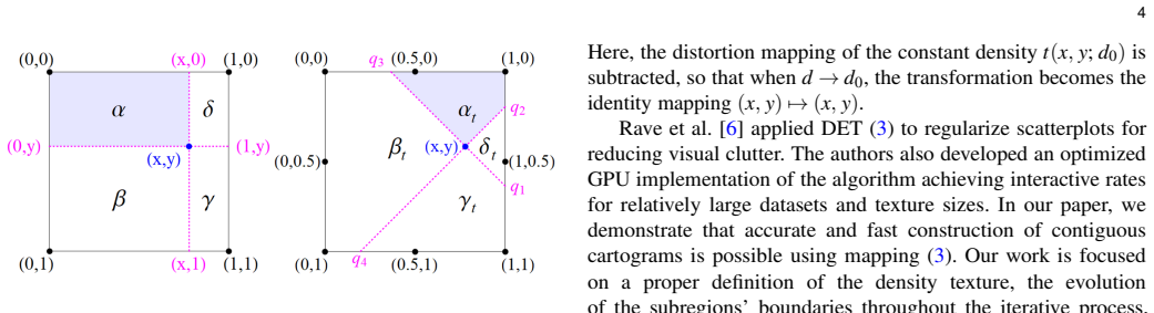
Integral images evaluated for density textures, applied in an iterative deformation process that equalizes region areas over time.
Load-bearing premise
The iterative mapping will gradually equalize densities without introducing unacceptable topological errors when controlled by one shape-preservation parameter.
What would settle it
A benchmark on standard geographic datasets where the new method produces higher topological error rates or slower runtimes than prior state-of-the-art algorithms.
Figures


read the original abstract
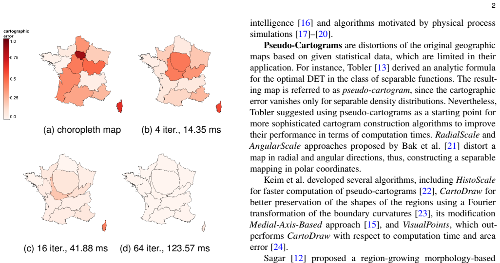
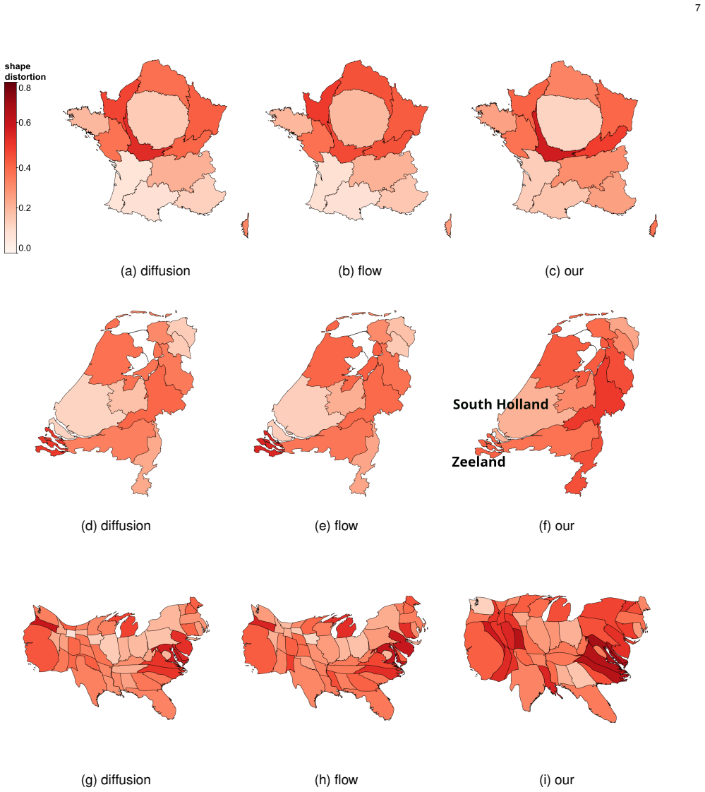
Cartograms are a technique for visually representing geographically distributed statistical data, where values of a numerical attribute are mapped to the size of geographic regions. Contiguous cartograms preserve the adjacencies of the original regions during the mapping. To be useful, contiguous cartograms also require approximate preservation of shapes and relative positions. Due to these desirable properties, contiguous cartograms are among the most popular ones. Most methods for constructing contiguous cartograms exploit a deformation of the original map. Aiming at the preservation of geographical properties, existing approaches are often algorithmically cumbersome and computationally intensive. We propose a novel deformation technique for computing time-varying contiguous cartograms based on integral images evaluated for a series of discrete density distributions. The density textures represent the given dynamic statistical data. The iterative application of the proposed mapping smoothly transforms the domain to gradually equalize the temporal density, i.e., region areas grow or shrink following their evolutionary statistical data. Global shape preservation at each time step is controlled by a single parameter that can be interactively adjusted by the user. Our efficient GPU implementation of the proposed algorithm is significantly faster than existing state-of-the-art methods while achieving comparable quality for cartographic accuracy, shape preservation, and topological error. We investigate strategies for transitioning between adjacent time steps and discuss the parameter choice. Our approach applies to comparative cartograms' morphing and interactive cartogram exploration.
Editorial analysis
A structured set of objections, weighed in public.
Referee Report
Summary. The paper proposes a novel deformation technique for computing time-varying contiguous cartograms by iteratively applying integral-image-based mappings to a sequence of density textures derived from dynamic statistical data. Region areas are adjusted to match evolving densities while a single user-adjustable parameter controls global shape preservation at each step. The authors present an efficient GPU implementation claimed to be significantly faster than existing state-of-the-art methods, with comparable cartographic accuracy, shape preservation, and topological error; they also discuss transitioning strategies between time steps and parameter choice, with applications to morphing and interactive exploration.
Significance. If the speed and quality claims hold under quantitative scrutiny, the work would offer a practical advance for interactive visualization of temporal geographic data, where current contiguous cartogram methods are often too slow for real-time use. The adaptation of integral images for density equalization is a direct and efficient reuse of a standard technique, and the single-parameter control could simplify user interaction if its robustness is demonstrated.
major comments (2)
- [Abstract] Abstract: the claims that the GPU implementation is 'significantly faster' and achieves 'comparable quality for cartographic accuracy, shape preservation, and topological error' are unsupported by any numerical benchmarks, timing tables, error metrics (e.g., area distortion, Hausdorff distance, or adjacency violation counts), or direct comparisons to prior methods. The evaluation section must supply these data to make the central performance assertion verifiable.
- [Iterative mapping and transitioning strategies] The section discussing iterative mapping and transitioning strategies: the assertion that a single global shape-preservation parameter suffices to keep topological error acceptable across time steps lacks supporting analysis. No bounds on the parameter, no enumeration of failure cases for steep or opposing density gradients, and no quantitative tracking of topological violations (e.g., adjacency flips or fold counts) across the sequence are provided, leaving the weakest assumption of the central claim untested.
minor comments (2)
- [Abstract] The abstract states that 'transitioning strategies were investigated' but provides no summary of the concrete strategies tested or their relative performance; a brief enumeration or table of outcomes would improve clarity.
- [Figures] Figure captions should explicitly state the value of the shape-preservation parameter, the number of iterations per time step, and any error visualizations used, so readers can reproduce the reported behavior.
Simulated Author's Rebuttal
We thank the referee for the constructive feedback. The comments highlight opportunities to strengthen the quantitative support for our claims and the analysis of our method's robustness. We address each major comment below and will incorporate revisions to improve verifiability.
read point-by-point responses
-
Referee: [Abstract] Abstract: the claims that the GPU implementation is 'significantly faster' and achieves 'comparable quality for cartographic accuracy, shape preservation, and topological error' are unsupported by any numerical benchmarks, timing tables, error metrics (e.g., area distortion, Hausdorff distance, or adjacency violation counts), or direct comparisons to prior methods. The evaluation section must supply these data to make the central performance assertion verifiable.
Authors: We agree that the abstract's performance claims require explicit numerical backing to be verifiable. Although the manuscript includes an evaluation section with runtime comparisons and qualitative quality discussions, we will expand it in revision to add detailed timing tables, quantitative error metrics (including area distortion, shape similarity measures, and counts of topological violations), and direct side-by-side comparisons against prior contiguous cartogram methods. The abstract will be updated to reference these specific results. revision: yes
-
Referee: [Iterative mapping and transitioning strategies] The section discussing iterative mapping and transitioning strategies: the assertion that a single global shape-preservation parameter suffices to keep topological error acceptable across time steps lacks supporting analysis. No bounds on the parameter, no enumeration of failure cases for steep or opposing density gradients, and no quantitative tracking of topological violations (e.g., adjacency flips or fold counts) across the sequence are provided, leaving the weakest assumption of the central claim untested.
Authors: We acknowledge that the current discussion of the shape-preservation parameter would benefit from more rigorous supporting analysis. In the revised manuscript we will add bounds derived from our experiments, enumerate potential failure cases for extreme density changes, and include quantitative plots tracking topological violations (adjacency flips and fold counts) across time sequences on multiple datasets. This will directly test the robustness of the single-parameter control. revision: yes
Circularity Check
No significant circularity in the integral-image cartogram deformation
full rationale
The paper introduces a deformation technique that applies established integral-image summation to density textures derived from time-varying statistical data, with iterative application to equalize region areas and a single user parameter for shape control. No load-bearing step reduces a claimed result to a self-defined quantity, a fitted parameter renamed as prediction, or a self-citation chain; the core mapping is algorithmic and builds on prior non-author work on integral images without smuggling ansatzes or renaming known results. Claims of speed and quality are positioned as empirical outcomes of the GPU implementation rather than tautological consequences of the inputs.
Axiom & Free-Parameter Ledger
free parameters (1)
- global shape preservation parameter
axioms (1)
- domain assumption Integral images provide an efficient and accurate means to evaluate cumulative sums for computing deformation mappings from density textures.
Reference graph
Works this paper leans on
-
[1]
M. T. Gastner and M. E. J. Newman. Diffusion-based method for producing density-equalizing maps. Pro- ceedings of the National Academy of Sciences , 101(20):7499–7504, 2004. doi: 10.1073/pnas.0400280101
-
[2]
M. T. Gastner, V. Seguy, and P. More. Fast flow-based algorithm for creating density-equalizing map projec- tions. Proceedings of the National Academy of Sciences , 115(10):E2156–E2164, February 2018. doi: 10.1073/pnas .1712674115
discussion (0)
Sign in with ORCID, Apple, or X to comment. Anyone can read and Pith papers without signing in.