Recognition: unknown
SatBLIP: Context Understanding and Feature Identification from Satellite Imagery with Vision-Language Learning
Pith reviewed 2026-05-10 13:05 UTC · model grok-4.3
The pith
SatBLIP adapts vision-language models to satellite tiles to predict county social vulnerability and pinpoint the visual features that drive those estimates.
A machine-rendered reading of the paper's core claim, the machinery that carries it, and where it could break.
Core claim
SatBLIP is a satellite-specific vision-language framework that predicts county-level Social Vulnerability Index by coupling contrastive image-text alignment with bootstrapped captioning tailored to satellite semantics. GPT-4o generates structured descriptions of satellite tiles covering roof type and condition, house size, yard attributes, greenery, and road context; these train a fine-tuned satellite-adapted BLIP model to produce captions for unseen images. The captions are encoded with CLIP, fused via attention with LLM-derived embeddings, and aggregated spatially to yield SVI estimates. SHAP analysis then identifies the salient attributes, including roof form and condition, street width,
What carries the argument
Bootstrapped captioning inside a fine-tuned satellite-adapted BLIP model, whose outputs are CLIP-encoded and attention-fused with LLM embeddings for SVI prediction, followed by SHAP attribution to surface driving visual features.
If this is right
- Produces county-level SVI estimates together with an explicit list of visual attributes that consistently influence the score.
- Moves remote-sensing vulnerability work away from handcrafted features or manual virtual audits toward automated caption-based reasoning.
- Supports interpretable mapping of rural risk environments by linking specific image elements such as roof condition or vegetation density to vulnerability outcomes.
- Allows spatial aggregation of tile-level predictions while retaining feature-level explanations for each county.
Where Pith is reading between the lines
- The same captioning-plus-attribution pipeline could be retrained on other socioeconomic or environmental indices that have county-level ground truth.
- If the SHAP-identified features prove stable across regions, they could serve as lightweight indicators for rapid assessment when full SVI data are unavailable.
- Continuous ingestion of fresh satellite tiles might allow periodic updates to vulnerability maps without retraining the entire model from scratch.
Load-bearing premise
GPT-4o-generated structured descriptions accurately and without bias capture the rural features visible in satellite tiles, and the fine-tuned BLIP model generalizes well enough to produce captions that improve SVI estimation on new images.
What would settle it
Run the full pipeline on a held-out set of counties using human-written descriptions of the same satellite tiles in place of GPT-4o captions and check whether prediction accuracy and the SHAP-ranked feature list remain stable or degrade sharply.
Figures


read the original abstract
Rural environmental risks are shaped by place-based conditions (e.g., housing quality, road access, land-surface patterns), yet standard vulnerability indices are coarse and provide limited insight into risk contexts. We propose SatBLIP, a satellite-specific vision-language framework for rural context understanding and feature identification that predicts county-level Social Vulnerability Index (SVI). SatBLIP addresses limitations of prior remote sensing pipelines-handcrafted features, manual virtual audits, and natural-image-trained VLMs-by coupling contrastive image-text alignment with bootstrapped captioning tailored to satellite semantics. We use GPT-4o to generate structured descriptions of satellite tiles (roof type/condition, house size, yard attributes, greenery, and road context), then fine-tune a satellite-adapted BLIP model to generate captions for unseen images. Captions are encoded with CLIP and fused with LLM-derived embeddings via attention for SVI estimation under spatial aggregation. Using SHAP, we identify salient attributes (e.g., roof form/condition, street width, vegetation, cars/open space) that consistently drive robust predictions, enabling interpretable mapping of rural risk environments.
Editorial analysis
A structured set of objections, weighed in public.
Referee Report
Summary. The manuscript proposes SatBLIP, a vision-language model for satellite imagery analysis that generates structured rural-feature captions (roof type/condition, house size, yard attributes, greenery, road context) from satellite tiles using GPT-4o, fine-tunes a satellite-adapted BLIP model on these captions, encodes the outputs with CLIP, and fuses them via attention with LLM-derived embeddings to predict county-level Social Vulnerability Index (SVI) under spatial aggregation; SHAP analysis is then applied to identify salient driving attributes such as roof form/condition, street width, vegetation, and cars/open space.
Significance. If the empirical claims hold after proper validation, the work could advance remote-sensing applications for social vulnerability by providing an interpretable, scalable alternative to handcrafted features or natural-image VLMs, enabling finer-grained mapping of rural risk contexts through satellite-derived attributes.
major comments (2)
- [Abstract] Abstract: the pipeline description states that GPT-4o captions are 'tailored to satellite semantics' and that the fine-tuned model 'generalizes,' yet no quantitative captioning metrics (e.g., BLEU, CIDEr, or human agreement scores), ablation on caption quality, or ground-truth validation against rural satellite features are reported; this is load-bearing because downstream SVI regression and SHAP attributions depend directly on the fidelity of the bootstrapped captions.
- [Abstract] Abstract (pipeline paragraph): the claim that SHAP identifies 'salient attributes ... that consistently drive robust predictions' cannot be evaluated because the manuscript supplies no performance metrics, error bars, cross-validation results, or baseline comparisons for the SVI regression task itself; without these, it is impossible to determine whether the identified features (roof condition, street width, vegetation) reflect genuine signals or artifacts of the GPT-4o training captions.
minor comments (1)
- [Abstract] Abstract: the phrase 'spatial aggregation' for SVI estimation is used without specifying the exact aggregation operator or spatial scale, which could be clarified for reproducibility.
Simulated Author's Rebuttal
We thank the referee for the constructive comments on our manuscript. The feedback highlights important aspects of empirical validation that we will strengthen in the revision. Below we respond point by point to the major comments.
read point-by-point responses
-
Referee: [Abstract] Abstract: the pipeline description states that GPT-4o captions are 'tailored to satellite semantics' and that the fine-tuned model 'generalizes,' yet no quantitative captioning metrics (e.g., BLEU, CIDEr, or human agreement scores), ablation on caption quality, or ground-truth validation against rural satellite features are reported; this is load-bearing because downstream SVI regression and SHAP attributions depend directly on the fidelity of the bootstrapped captions.
Authors: We agree that quantitative evaluation of the captioning stage is essential given its role in the pipeline. The current manuscript reports qualitative examples and downstream SVI results but does not include standard captioning metrics or ablations. In the revised version we will add BLEU and CIDEr scores computed against a held-out set of human-written rural satellite captions, inter-annotator agreement from domain experts, and an ablation that replaces GPT-4o captions with generic natural-image captions to quantify the benefit of satellite-tailored bootstrapping. Ground-truth validation against rural feature checklists will also be reported. revision: yes
-
Referee: [Abstract] Abstract (pipeline paragraph): the claim that SHAP identifies 'salient attributes ... that consistently drive robust predictions' cannot be evaluated because the manuscript supplies no performance metrics, error bars, cross-validation results, or baseline comparisons for the SVI regression task itself; without these, it is impossible to determine whether the identified features (roof condition, street width, vegetation) reflect genuine signals or artifacts of the GPT-4o training captions.
Authors: We acknowledge that the abstract's phrasing implies robustness without sufficient supporting statistics. The full manuscript contains spatial cross-validation and baseline comparisons (direct CLIP, handcrafted features), yet these details are not highlighted in the abstract and lack error bars. In revision we will expand the results section with MAE, R², and RMSE values plus standard-error bars across folds, explicit baseline tables, and a sensitivity analysis showing that SHAP attributions remain stable when caption quality is varied. This will allow readers to assess whether the highlighted attributes are genuine drivers. revision: yes
Circularity Check
No significant circularity detected in the derivation chain
full rationale
The paper describes a pipeline that uses external GPT-4o to produce initial structured captions from satellite tiles, fine-tunes a BLIP model on those captions, generates captions for new images, encodes them via CLIP, fuses with LLM embeddings through attention, and regresses to county-level SVI labels. The SVI targets are independent external data, so the regression outputs are not equivalent to the caption-generation inputs by construction. No equations, self-citations, uniqueness theorems, or ansatzes from prior author work are quoted that would reduce any load-bearing step to a fitted parameter or self-referential definition. The derivation remains self-contained against external SVI benchmarks and held-out evaluation.
Axiom & Free-Parameter Ledger
axioms (2)
- domain assumption GPT-4o can generate accurate structured descriptions of satellite imagery features such as roof type/condition and road context
- domain assumption The fine-tuned satellite-adapted BLIP model produces generalizable captions for unseen satellite tiles
Reference graph
Works this paper leans on
-
[1]
2020.Generating Interpretable Poverty Maps using Object Detection in Satellite Images
Kumar Ayush, Burak Uzkent, Marshall Burke, David Lobell, and Stefano Ermon. 2020.Generating Interpretable Poverty Maps using Object Detection in Satellite Images. Technical Report
2020
-
[2]
Yuzhou Chen, Jiue-An Yang, Hugo Kyo Lee, Calvin Tribby, Tarik Benmarhnia, Marta Jankowska, and Yulia R. Gel. 2025. Fusing Multimodality of Large Language Models and Satellite Imagery via Simplicial Contrastive Learning for Latent Urban Feature Identification and Environmental Application. Institute of Electrical and Electronics Engineers (IEEE), 1–5. doi:...
-
[3]
Natalie Danielle Crawford, Regine Haardöerfer, Hannah Cooper, Izraelle McK- innon, Carla Jones-Harrell, April Ballard, Sierra Shantel von Hellens, and April Young. 2019. Characterizing the rural opioid use environment in Kentucky using Google Earth: Virtual audit.Journal of Medical Internet Research21 (10 2019). Issue 10. doi:10.2196/14923
-
[4]
2023.Sat2Cap: Mapping Fine-Grained Textual Descriptions from Satellite Images
Aayush Dhakal, Adeel Ahmad, Subash Khanal, Srikumar Sastry, Hannah Kerner, and Nathan Jacobs. 2023.Sat2Cap: Mapping Fine-Grained Textual Descriptions from Satellite Images. Technical Report
2023
-
[5]
Barry E. Flanagan, Edward W. Gregory, Elaine J. Hallisey, Janet L. Heitgerd, and Brian Lewis. 2020. A Social Vulnerability Index for Disaster Management. Journal of Homeland Security and Emergency Management8 (2020). Issue 1. doi:10.2202/1547-7355.1792
-
[6]
Neal Jean, Marshall Burke, Michael Xie, W Matthew, Alampay Davis, David B Lobell, and Stefano Ermon. 2016. Combining satellite imagery and machine learning to predict poverty. (2016). doi:10.1126/science.aaf7894
-
[7]
2025.SatCLIP: Global, General-Purpose Location Embeddings with Satellite Imagery
Konstantin Klemmer, Esther Rolf, Caleb Robinson, Lester Mackey, and Marc Rußwurm. 2025.SatCLIP: Global, General-Purpose Location Embeddings with Satellite Imagery. Technical Report. www.aaai.org
2025
-
[8]
Junnan Li, Dongxu Li, Caiming Xiong, and Steven Hoi. 2022. BLIP: Bootstrapping Language-Image Pre-training for Unified Vision-Language Understanding and Generation. InICML
2022
-
[9]
2017.A Unified Approach to Interpreting Model Predictions
Scott M Lundberg, Paul G Allen, and Su-In Lee. 2017.A Unified Approach to Interpreting Model Predictions. Technical Report. https://github.com/slundberg/ shap
2017
-
[10]
Dana Moukheiber, David Restrepo, Sebastián Andrés Cajas, María Patricia Ar- beláez Montoya, Leo Anthony Celi, Kuan Ting Kuo, Diego M. López, Lama Moukheiber, Mira Moukheiber, Sulaiman Moukheiber, Juan Sebastian Osorio- Valencia, Saptarshi Purkayastha, Atika Rahman Paddo, Chenwei Wu, and Po Chih Kuo. 2024. A multimodal framework for extraction and fusion o...
-
[11]
Ye Ni, Xutao Li, Yunming Ye, Yan Li, Chunshan Li, and Dianhui Chu. 2020. An Investigation on Deep Learning Approaches to Combining Nighttime and Daytime Satellite Imagery for Poverty Prediction.IEEE Geoscience and Remote Sensing Letters18 (7 2020), 1545–1549. Issue 9. doi:10.1109/lgrs.2020.3006019
-
[12]
Alec Radford, Jong Wook Kim, Chris Hallacy, Aditya Ramesh, Gabriel Goh, Sandhini Agarwal, Girish Sastry, Amanda Askell, Pamela Mishkin, Jack Clark, Gretchen Krueger, and Ilya Sutskever. 2021. Learning Transferable Visual Models From Natural Language Supervision. (2 2021). http://arxiv.org/abs/2103.00020
work page internal anchor Pith review Pith/arXiv arXiv 2021
-
[13]
Tim Rhodes. 2002. The ’risk environment’: A framework for understanding and reducing drug-related harm.International Journal of Drug Policy13 (2002), 85–94. Issue 2. doi:10.1016/S0955-3959(02)00007-5
-
[14]
Tim Rhodes. 2009. Risk environments and drug harms: A social science for harm reduction approach.International Journal of Drug Policy20 (2009), 193–201. Issue
2009
-
[15]
doi:10.1016/j.drugpo.2008.10.003
-
[16]
2024.Charting New Territories: Exploring the Geographic and Geospatial Capabilities of Multimodal LLMs Correct Correct Continent
Jonathan Roberts, Timo Lüddecke, Kai Han, and Samuel Albanie. 2024.Charting New Territories: Exploring the Geographic and Geospatial Capabilities of Multimodal LLMs Correct Correct Continent. Technical Report. https://chat.openai.com/
2024
-
[17]
2024.GeoLLM-Engine: A Realistic Environment for Building Geospatial Copilots
Simranjit Singh, Michael Fore, and Dimitrios Stamoulis. 2024.GeoLLM-Engine: A Realistic Environment for Building Geospatial Copilots. Technical Report
2024
- [18]
-
[19]
Gary R. Watmough, Charlotte L.J. Marcinko, Clare Sullivan, Kevin Tschirhart, Patrick K. Mutuo, Cheryl A. Palm, and Jens Christian Svenning. 2019. Socioeco- logically informed use of remote sensing data to predict rural household poverty. Proceedings of the National Academy of Sciences of the United States of America 116 (1 2019), 1213–1218. Issue 4. doi:1...
-
[20]
Xue Wu, Shengting Cao, and Jiaqi Gong. 2026. Deep learning-based spatio- temporal framework for opioid overdose monitoring in rural Alabama.Artificial Intelligence in Health0 (1 2026), 025380076. Issue 0. doi:10.36922/AIH025380076
-
[21]
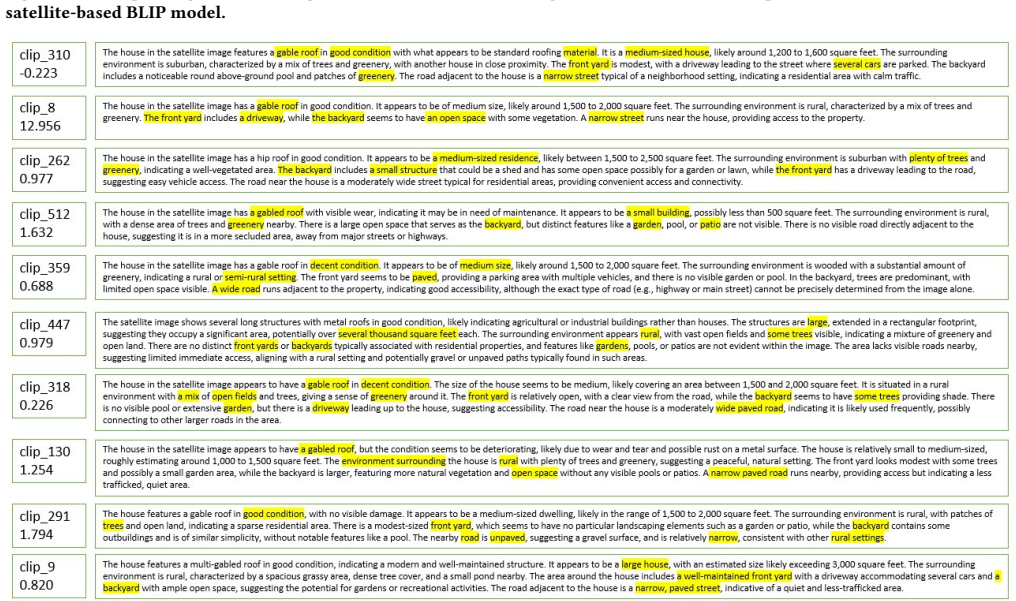
Xue Wu, Shengting Cao, Hee Yun Lee, and Jiaqi Gong. 2022. Let Every Voice Be Heard: Developing a Cost-Effective Community Sampling Frame in Rural Figure 3: Descriptions generated using BLIP model for satellite images with Pre-trained checkpoints, LLaV A, and our trained satellite-based BLIP model. Figure 4: Top 10 SHAP-important dimensions with top descri...
-
[22]
Xue Wu and Jiaqi Gong. 2025. Advancing Data Quality for Healthcare AI: Integrat- ing Google Earth and Community Data in Opioid Crisis Mitigation.Proceedings of ACM/IEEE International Conference on Connected Health: Applications, Systems and Engineering Technologies (CHASE ’25)(2025). doi:10.1145/3721201.3725436
discussion (0)
Sign in with ORCID, Apple, or X to comment. Anyone can read and Pith papers without signing in.