Recognition: 2 theorem links
· Lean TheoremShipEcho -- An Interactive Tool for Global Mapping of Underwater Radiated Noise from Vessels
Pith reviewed 2026-05-12 00:45 UTC · model grok-4.3
The pith
ShipEcho generates near-real-time worldwide maps of underwater ship noise by combining public AIS vessel data with standard source models and ocean depth information.
A machine-rendered reading of the paper's core claim, the machinery that carries it, and where it could break.
Core claim
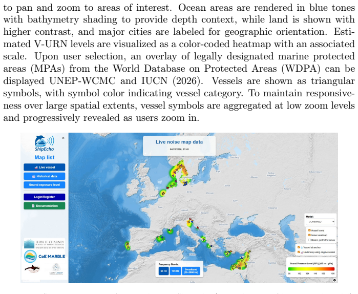
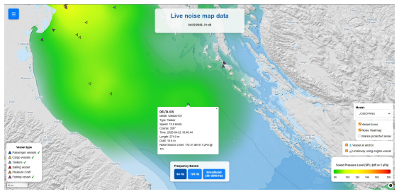
ShipEcho is a freely accessible web-based GIS that produces near-real-time V-URN mapping from community-sourced AIS vessel data. It applies established vessel source level models and propagation modeling informed by bathymetric data to output sound pressure levels and sound exposure levels using the 63 Hz and 125 Hz one-third octave bands plus a 20-2000 Hz broadband indicator. The maps are validated through comparison with acoustic recordings and are shown to support management-level assessment, decision-making, and policy initiatives.
What carries the argument
The ShipEcho web GIS platform, which ingests AIS vessel positions and attributes, applies vessel source level models, and computes sound propagation using bathymetric data to generate and display noise maps in standard acoustic indicators.
If this is right
- Global V-URN maps become available without dependence on sparse passive acoustic arrays or costly wide-area data purchases.
- Managers obtain actionable spatiotemporal noise information for environmental assessment and mitigation planning.
- Cumulative exposure maps support policy initiatives and regulatory frameworks for vessel noise reduction.
- Direct comparison with acoustic recordings provides an ongoing check on map reliability across regions.
Where Pith is reading between the lines
- The tool could be linked to species-specific sensitivity maps to forecast noise exposure for particular marine populations.
- Community AIS contributions open a route for ongoing public updates to noise maps in high-traffic shipping corridors.
- Adding vessel speed or seasonal oceanographic layers would allow users to test how changes in traffic patterns alter predicted noise fields.
Load-bearing premise
The selected vessel source level models and the bathymetry-based propagation model remain accurate for the full global variety of vessel types, speeds, and ocean conditions present in the AIS data.
What would settle it
Consistent large mismatches between ShipEcho map values and independent acoustic recordings collected in areas with mixed vessel traffic and complex bathymetry would show that the models fail to generalize.
Figures


read the original abstract
Underwater radiated noise from vessels (V-URN) is a recognized environmental stressor that negatively impacts marine ecosystems. Significant resources are invested in the development of V-URN monitoring indicators, regulatory frameworks, and management-oriented assessments. One approach with high potential for impact is V-URN mapping, which can provide actionable spatiotemporal information for environmental assessment and mitigation planning. Producing management-scale maps remains challenging as passive acoustic measurements are spatially sparse and many operational systems depend on specialist workflows and costly access to wide-area vessel activity data. To address these constraints, we introduce ShipEcho, a freely accessible web-based Geographic Information System (GIS) that provides near-real-time V-URN mapping using vessel data acquired through a community-based AIS exchange. Using established vessel SL models and propagation modeling informed by bathymetric data, ShipEcho produces near-real-time and cumulative noise maps across regions worldwide. These include sound pressure levels and sound exposure levels using standard indicators, including the 63~Hz and 125~Hz one-third octave bands and a 20--2000~Hz broadband level. We describe the system architecture, data pipeline, modeling workflow, and key assumptions, and evaluate map accuracy through comparison with acoustic recordings. We then demonstrate how ShipEcho can support management-level assessment, decision-making, and policy initiatives through practical use cases.
Editorial analysis
A structured set of objections, weighed in public.
Referee Report
Summary. The manuscript introduces ShipEcho, a freely accessible web-based GIS tool for producing near-real-time and cumulative maps of underwater radiated noise from vessels (V-URN) worldwide. It ingests AIS data via a community exchange, applies established vessel source-level models together with bathymetry-informed propagation modeling, and outputs maps using standard indicators (63 Hz and 125 Hz one-third-octave bands plus 20–2000 Hz broadband sound pressure and exposure levels). The paper describes the system architecture, data pipeline, modeling workflow and assumptions, states that map accuracy was evaluated against acoustic recordings, and illustrates management and policy use cases.
Significance. If the accuracy evaluation holds, the tool would be a useful practical contribution to marine environmental management by lowering barriers to global-scale V-URN mapping without specialist software or proprietary data. Credit is due for the open, community-data-driven design, reliance on published models without new free parameters or invented entities, and the explicit demonstration of decision-support workflows.
major comments (1)
- The abstract and evaluation description state that map accuracy was evaluated by comparison with acoustic recordings, yet no quantitative error metrics, correlation coefficients, RMSE values, or rules for data exclusion are reported. This information is load-bearing for the central claim that the resulting maps are usable for management-level assessment and policy initiatives.
minor comments (1)
- In the modeling workflow section, explicitly state the propagation model employed and any assumptions regarding sound-speed profiles or seasonal variability, as these directly affect the global applicability asserted in the abstract.
Simulated Author's Rebuttal
We thank the referee for their constructive review and for identifying this gap in the reporting of our validation results. We address the major comment below and will revise the manuscript accordingly.
read point-by-point responses
-
Referee: The abstract and evaluation description state that map accuracy was evaluated by comparison with acoustic recordings, yet no quantitative error metrics, correlation coefficients, RMSE values, or rules for data exclusion are reported. This information is load-bearing for the central claim that the resulting maps are usable for management-level assessment and policy initiatives.
Authors: We agree that the current manuscript does not provide the quantitative details of the accuracy evaluation. While the abstract and evaluation section mention comparison with acoustic recordings, specific metrics such as RMSE, correlation coefficients, and explicit data exclusion rules (e.g., SNR thresholds or spatial matching criteria) are not reported. In the revised manuscript we will add a new subsection and accompanying table that presents these quantitative results, including the number of validation sites, the computed error statistics, and the precise rules applied for data inclusion or exclusion. This will directly support the usability claims for management and policy applications. revision: yes
Circularity Check
No significant circularity detected
full rationale
The paper describes a practical web-based GIS tool that generates V-URN maps by applying established, pre-existing vessel source-level models and bathymetry-informed propagation models to external AIS data. No new derivations, equations, or fitted parameters are introduced within the paper itself; the core pipeline relies on published external models and independent acoustic recordings for validation. The central claims concern tool functionality, map production, and evaluation against external data, with no self-definitional reductions, fitted-input predictions, or load-bearing self-citations that collapse the output to internal inputs by construction.
Axiom & Free-Parameter Ledger
axioms (2)
- domain assumption Established vessel source level (SL) models remain accurate for the vessel types and operating conditions present in the global AIS dataset.
- domain assumption Bathymetry-informed propagation modeling produces usable noise level estimates at management scales.
Lean theorems connected to this paper
-
IndisputableMonolith/Cost/FunctionalEquation.leanwashburn_uniqueness_aczel unclearUsing established vessel SL models and propagation modeling informed by bathymetric data, ShipEcho produces near-real-time and cumulative noise maps across regions worldwide... Gaussian ray-tracing approach that accounts for bathymetry and sound-speed profile
-
IndisputableMonolith/Foundation/RealityFromDistinction.leanreality_from_one_distinction unclearThe propagation model uses bathymetry and the sound-speed profile (SSP) as its main environmental inputs... Gaussian beam weighting
Reference graph
Works this paper leans on
-
[1]
Protected Planet: The World Database on Protected Areas (WDPA) , year =
-
[2]
The Journal of the Acoustical Society of America , volume=
Sound exposure level as a metric for analyzing and managing underwater soundscapes , author=. The Journal of the Acoustical Society of America , volume=. 2019 , publisher=
work page 2019
-
[3]
ICES Journal of Marine Science , volume=
A sound approach to assessing the impact of underwater noise on marine fishes and invertebrates , author=. ICES Journal of Marine Science , volume=. 2017 , publisher=
work page 2017
-
[4]
Vieira, M. and Beauchaud, M. and Amorim, M. C. P. and Fonseca, P. J. , journal =. Boat noise affects meagre (. 2021 , volume =
work page 2021
-
[5]
Frontiers in Marine Science , year =
A Meta-Analysis to Understand the Variability in Reported Source Levels of Noise Radiated by Ships From Opportunistic Studies , author =. Frontiers in Marine Science , year =. doi:10.3389/fmars.2019.00714 , url =
-
[6]
Graves, R. D. , title =. The Journal of the Acoustical Society of America , volume =
-
[7]
Porter, Michael B. and Bucker, Homer P. , title =. The Journal of the Acoustical Society of America , year =
-
[8]
Commission Decision (EU) 2017/848 of 17 May 2017 laying down criteria and methodological standards on good environmental status of marine waters and specifications and standardised methods for monitoring and assessment, repealing Decision 2010/477/EU , year =
work page 2017
-
[9]
West, M. and Gilbert, K. E. and Sack, R. A. , title =. Applied Acoustics , year =
-
[10]
AIS data sharing and vessel tracking by AISHub , year =
-
[11]
North Sea Sound Maps 2019--2020 , author =. 2022 , month = jun, type =
work page 2019
- [12]
-
[13]
World Ocean Atlas , year =
-
[14]
Gridded Bathymetry Data , howpublished =
-
[15]
The Journal of the Acoustical Society of America , volume=
Acoustic ambient noise in the ocean: spectra and sources , author=. The Journal of the Acoustical Society of America , volume=. 1962 , doi=
work page 1962
-
[16]
Methods in Ecology and Evolution , volume=
Measuring acoustic habitats , author=. Methods in Ecology and Evolution , volume=. 2015 , doi=
work page 2015
-
[17]
The Journal of Marine Research , volume=
Underwater ambient noise , author=. The Journal of Marine Research , volume=
- [18]
-
[19]
Niels Provos and David Mazi. A. 1999. 1999 , address =
work page 1999
- [20]
- [21]
-
[22]
Thorp, W. H. , title =. The Journal of the Acoustical Society of America , year =
-
[23]
Analysis and modeling of 255 source levels of merchant ships from an acoustic observatory along St. Lawrence Seaway , author=. The Journal of the Acoustical Society of America , volume=. 2016 , publisher=
work page 2016
-
[24]
Technical characteristics for an automatic identification system using time division multiple access in the VHF maritime mobile frequency band , year =
-
[25]
Transport Infrastructure and Systems , pages=
Analysis of the maritime traffic in the central part of the Adriatic , author=. Transport Infrastructure and Systems , pages=. 2017 , publisher=
work page 2017
-
[26]
McDonald, Mark A. and Hildebrand, John A. and Wiggins, Sean M. , journal =. Increases in deep ocean ambient noise in the Northeast Pacific west of. 2006 , volume =
work page 2006
-
[27]
The Journal of the Acoustical Society of America , year =
Low frequency deep ocean ambient noise trend in the Northeast Pacific Ocean , author =. The Journal of the Acoustical Society of America , year =
-
[28]
Trends in Ecology & Evolution , year =
A noisy spring: the impact of globally rising underwater sound levels on fish , author =. Trends in Ecology & Evolution , year =
-
[29]
Admiralty Inlet Slowdown , year =
-
[30]
Merchant, Nathan D. and Witt, Matthew J. and Blondel, Philippe and Godley, Brendan J. and Smith, George H. , title =. Marine Pollution Bulletin , year =. doi:10.1016/j.marpolbul.2012.05.004 , url =
-
[31]
Haver, Samara M. and Adams, Jeffrey D. and Hatch, Leila T. and Van Parijs, Sofie M. and Dziak, Robert P. and Haxel, Joseph and Heppell, Scott A. and McKenna, Megan F. and Mellinger, David K. and Gedamke, Jason , title =. Frontiers in Marine Science , year =. doi:10.3389/fmars.2021.669528 , url =
-
[32]
ECHO Program's 2026 voluntary slowdowns and route alteration for commercial ships , year =
work page 2026
-
[33]
Frontiers in Marine Science , year =
The Effects of Ship Noise on Marine Mammals---A Review , author =. Frontiers in Marine Science , year =
-
[34]
EMODnet Human Activities, Vessel Density Map , year =
-
[35]
Frontiers in Marine Science , year =
Shipton, Mark and Diamant, Roee , title =. Frontiers in Marine Science , year =. doi:10.3389/fmars.2026.1759355 , url =
-
[36]
Ocean & Coastal Management , volume=
The potential for vessel noise to mask biologically important sounds within ecologically significant embayments , author=. Ocean & Coastal Management , volume=. 2016 , publisher=
work page 2016
-
[37]
MacGillivray, Alexander O. and Martin, S. Bruce and Ainslie, Michael A. and Dolman, Joshua N. and Li, Zizheng and Warner, Graham A. , title =. The Journal of the Acoustical Society of America , year =
- [38]
-
[39]
Ross, Donald and Alvarez, F. F. , title =. U.S. Navy Journal of Underwater Acoustics , year =
-
[40]
IEEE Communications Letters , volume=
Localization using ray tracing for underwater acoustic sensor networks , author=. IEEE Communications Letters , volume=. 2010 , publisher=
work page 2010
-
[41]
Journal of Computational Acoustics , year=
Sonar propagation modeling using hybrid Gaussian beams in spherical/time coordinates , author=. Journal of Computational Acoustics , year=
-
[42]
EUNIS --- Site factsheet for
-
[43]
Ship Underwater Radiated Noise Patterns , author =
- [44]
-
[45]
Reagan, James R. and Garcia, Hernan E. and Boyer, Timothy P. and Baranova, Olga K. and Bouchard, Courtney and Cross, Scott L. and Dukhovskoy, Dmitry and Grodsky, Alexandra I. and Locarnini, Ricardo A. and Mishonov, Alexey V. and Paver, Christopher R. and Seidov, Dan and Wang, Zhankun , title =. 2024 , url =
work page 2024
-
[46]
Journal of Marine Science and Engineering , year =
A Reference Spectrum Model for Estimating Source Levels of Marine Shipping Based on Automated Identification System Data , author =. Journal of Marine Science and Engineering , year =
-
[47]
Breeding, J. E. and Pflug, L. A. and Bradley, M. and Walrod, M. and McBride, W. , institution =
- [48]
discussion (0)
Sign in with ORCID, Apple, or X to comment. Anyone can read and Pith papers without signing in.