Optimizing Latent Representations for Robust Building Damage Assessment Onboard Earth Observation Satellites
Pith reviewed 2026-06-29 08:29 UTC · model grok-4.3
The pith
Pre-disaster satellite images encoded into compact latents on the ground can be sent to orbit for direct onboard comparison with new post-event captures to assess building damage.
A machine-rendered reading of the paper's core claim, the machinery that carries it, and where it could break.
Core claim
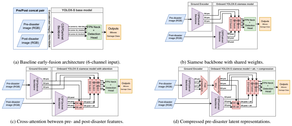
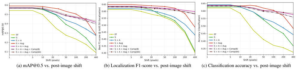
The authors design a system that encodes available pre-disaster images on the ground into compact latent representations, transmits them to the satellite, and performs object-level building damage assessment onboard by comparing those latents to newly captured post-event observations. They systematically test onboard-compatible model variants that use siamese architectures, cross-attention mechanisms, latent-space compression, and data augmentation aimed at robustness. On the xBD dataset the approach produces reliable damage localization and classification that remains stable under misalignment and suffers only minimal degradation even at high compression rates.
What carries the argument
Compact latent representations of pre-disaster images transmitted to the satellite and compared onboard against post-event observations via siamese or cross-attention networks.
If this is right
- Full post-disaster imagery no longer needs to be downlinked, shrinking data volume and transmission time.
- Damage maps become available faster because assessment happens at the satellite rather than after ground receipt and processing.
- The same latent pipeline stays effective even when pre- and post-images are not perfectly aligned.
- Strong compression of the latents preserves enough information that classification performance drops only slightly.
- Architectural choices such as siamese networks or cross-attention can be tuned to fit onboard hardware limits while retaining accuracy.
Where Pith is reading between the lines
- The same latent-comparison approach could be adapted to other onboard change-detection tasks such as monitoring crop health or urban expansion.
- If the latents retain sufficient information, the method might generalize to additional sensor types like multispectral or synthetic-aperture radar for different disaster categories.
- Satellites could use the onboard output to decide which full images or regions to downlink for later human review, creating a selective transmission policy.
- End-to-end simulation of the full ground-to-orbit pipeline would reveal whether cumulative errors from encoding, transmission, and onboard inference remain within acceptable bounds.
Load-bearing premise
Pre-disaster images are available in advance and can be turned into compact latents that still contain enough task-relevant information for accurate damage classification when compared to post-event images.
What would settle it
A test showing that damage classification accuracy falls below operational thresholds once realistic levels of misalignment or the target compression ratios are applied.
Figures

read the original abstract
Rapid identification of damaged buildings after natural disasters or on war areas is crucial to support emergency response and prioritize interventions. Earth Observation constellations provide timely, large-scale coverage, but actionable information is often delayed by data downlink constraints, on-ground processing, and human interpretation. Reducing this latency is essential to improve decision-making responsiveness. In this work, we propose an original AI-based system that enables object-level building damage assessment (localization and damage classification) directly onboard satellites from pre-disaster and post-disaster highresolution optical imagery. Available pre-disaster images are encoded on ground into compact latent representations, transmitted to the satellite, and compared on-board with newly acquired post-event observations. Leveraging AI interpretation capabilities and increasing processing capabilities on-board satellites, the proposed design enables processing directly at the data source, reducing the amount of information to be downlinked while preserving task-relevant content and improving overall system responsivity. We explore the design space through a systematic benchmark of onboard-compatible variants, analyzing the impact of siamese processing, cross-attention, latent-space compression, and robustness-oriented data augmentation. Experiments on xBD dataset demonstrate reliable and robust damage assessment under misalignment, with minimal performance degradation under strong compression.
Editorial analysis
A structured set of objections, weighed in public.
Referee Report
Summary. The paper proposes an AI-based onboard system for object-level building damage assessment (localization and classification) on Earth observation satellites. Pre-disaster images are encoded on-ground into compact latent representations that are uplinked; these are compared onboard with newly acquired post-event imagery using siamese or cross-attention architectures. The work systematically benchmarks design variants (siamese processing, cross-attention, latent compression, robustness-oriented augmentation) and reports that experiments on the xBD dataset demonstrate reliable damage assessment under misalignment with only minimal performance degradation under strong compression.
Significance. If the reported robustness transfers to real orbital conditions, the approach could materially reduce downlink volume and latency for disaster response by moving task-relevant inference to the sensor. The explicit focus on onboard-compatible constraints and the structured ablation of architectural and augmentation choices constitute a practical contribution to edge-AI deployment in remote-sensing.
major comments (1)
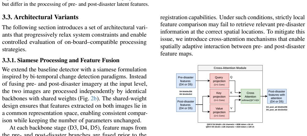
- [Experiments] Experiments section: the misalignment robustness claim rests on simulated shifts and standard augmentations applied to xBD pre/post pairs. This does not reproduce the composite effects of satellite revisit geometry, parallax, atmospheric distortion, and differing acquisition angles that occur in actual pre/post-event passes. Because the central claim is that the system remains reliable under the misalignment regime encountered onboard, the current simulation constitutes a load-bearing gap that must be closed (e.g., by more physically grounded perturbation models or real multi-pass pairs).
minor comments (1)
- [Abstract] Abstract and introduction: quantitative metrics (accuracy, F1, degradation percentages) and dataset-split details are absent from the high-level claims, forcing the reader to consult later sections for any assessment of effect size.
Simulated Author's Rebuttal
We thank the referee for the constructive feedback and the opportunity to clarify and strengthen our manuscript. We address the single major comment below.
read point-by-point responses
-
Referee: Experiments section: the misalignment robustness claim rests on simulated shifts and standard augmentations applied to xBD pre/post pairs. This does not reproduce the composite effects of satellite revisit geometry, parallax, atmospheric distortion, and differing acquisition angles that occur in actual pre/post-event passes. Because the central claim is that the system remains reliable under the misalignment regime encountered onboard, the current simulation constitutes a load-bearing gap that must be closed (e.g., by more physically grounded perturbation models or real multi-pass pairs).
Authors: We agree that the current misalignment experiments rely on simulated shifts and standard augmentations applied to xBD pairs and therefore do not fully capture the composite real-world effects of orbital geometry, parallax, atmospheric distortion, and differing acquisition angles. While xBD remains the primary public benchmark for this task and our augmentations follow established practices for testing robustness to misalignment, the referee correctly identifies a limitation in the load-bearing claim. In the revised manuscript we will (i) replace the simple shift/rotation augmentations with a more physically grounded perturbation model that incorporates parallax and view-angle effects derived from typical satellite revisit parameters, (ii) report the updated quantitative results, and (iii) add an explicit limitations paragraph discussing the remaining gap between simulation and real multi-pass acquisitions. revision: yes
Circularity Check
No circularity: experimental benchmark with no derivations or self-referential predictions
full rationale
The paper is an empirical study that benchmarks siamese/cross-attention variants, compression, and data augmentation on the xBD dataset for onboard damage assessment. No equations, derivations, fitted parameters renamed as predictions, or load-bearing self-citations appear in the provided text or abstract. All claims rest on direct experimental measurements rather than any chain that reduces to its own inputs by construction. The work is therefore self-contained against external benchmarks.
Axiom & Free-Parameter Ledger
Reference graph
Works this paper leans on
-
[1]
Seneca: Change detection in optical imagery using siamese networks with active-transfer learning
Giuseppina Andresini, Annalisa Appice, Dino Ienco, and Donato Malerba. Seneca: Change detection in optical imagery using siamese networks with active-transfer learning. Expert Systems with Applications, 214:119123, 2023. 2
2023
-
[2]
Fully convolutional siamese networks for change detection
Rodrigo Caye Daudt, Bertr Le Saux, and Alexandre Boulch. Fully convolutional siamese networks for change detection. In 2018 25th IEEE International Conference on Image Pro- cessing (ICIP), pages 4063–4067, 2018. 2
2018
-
[3]
Building dam- age assessment based on siamese hierarchical transformer framework
Yifan Da, Zhiyuan Ji, and Yongsheng Zhou. Building dam- age assessment based on siamese hierarchical transformer framework. Mathematics, 10(11), 2022. 2
2022
-
[4]
Explaining raw data com- plexity to improve satellite on-board processing
Adrien Dorise, Marjorie Bellizzi, Adrien Girard, Benjamin Francesconi, and St´ephane May. Explaining raw data com- plexity to improve satellite on-board processing. In 2025 European Data Handling & Data Processing Conference (EDHPC), pages 1–8, 2025. 2, 8
2025
-
[5]
An Image is Worth 16x16 Words: Transformers for Image Recognition at Scale
Alexey Dosovitskiy, Lucas Beyer, Alexander Kolesnikov, Dirk Weissenborn, Xiaohua Zhai, Thomas Unterthiner, Mostafa Dehghani, Matthias Minderer, Georg Heigold, Syl- vain Gelly, Jakob Uszkoreit, and Neil Houlsby. An image is worth 16x16 words: Transformers for image recognition at scale. CoRR, abs/2010.11929, 2020. 2
work page internal anchor Pith review Pith/arXiv arXiv 2010
-
[6]
From event to action: A reactive loop demon- strator for earth observation based on modular ai-driven com- ponents
Benjamin Francesconi, Luis Palluel, Thomas Goudemant, Hugo Meleiro, Benjamin Marchand, Olivier Thiery, and France Creil. From event to action: A reactive loop demon- strator for earth observation based on modular ai-driven com- ponents. In Actes de la 7`eme Conference on Artificial Intelli- gence for Defense (CAID 2025), 2025. 2, 7
2025
-
[7]
YOLOX: Exceeding YOLO Series in 2021
Zheng Ge, Songtao Liu, Feng Wang, Zeming Li, and Jian Sun. Yolox: Exceeding yolo series in 2021. arXiv preprint arXiv:2107.08430, 2021. 3, 6
work page internal anchor Pith review Pith/arXiv arXiv 2021
-
[8]
D ´etection de navires embarquable `a bord de satellites
Thomas Goudemant, Benjamin Francesconi, Houssem Farhat, Lionel Daniel, Olivier Thiery, Erwann Kervennic, Adrien Gi- rard, and Seif Mzoughi. D ´etection de navires embarquable `a bord de satellites. In Actes de la 4`eme Conference on Artifi- cial Intelligence for Defense (CAID 2022), Rennes, France,
2022
-
[9]
DGA Maˆıtrise de l’Information. 2, 7
-
[10]
xbd: A dataset for assessing building damage from satellite imagery, 2019
Ritwik Gupta, Richard Hosfelt, Sandra Sajeev, Nirav Patel, Bryce Goodman, Jigar Doshi, Eric Heim, Howie Choset, and Matthew Gaston. xbd: A dataset for assessing building damage from satellite imagery, 2019. 1, 2, 5
2019
-
[11]
A survey on deep learning-based change detection from high- resolution remote sensing images
Huiwei Jiang, Min Peng, Yuanjun Zhong, Haofeng Xie, Zemin Hao, Jingming Lin, Xiaoli Ma, and Xiangyun Hu. A survey on deep learning-based change detection from high- resolution remote sensing images. Remote Sensing, 14(7),
-
[12]
SSD: Single Shot MultiBox Detector
Wei Liu, Dragomir Anguelov, Dumitru Erhan, Christian Szegedy, Scott E. Reed, Cheng-Yang Fu, and Alexan- der C. Berg. SSD: single shot multibox detector. CoRR, abs/1512.02325, 2015. 2
work page internal anchor Pith review Pith/arXiv arXiv 2015
-
[13]
Implementation of the ϕsat-2 on board image processing chain
N Melega, Bernardo A Carnicero, N Longepe, A Paskeviciute, V Marchese, Oriol Aragon, Irina Babkina, Alessandro Marin, Jakub Nalepa, Leonie Buckley, et al. Implementation of the ϕsat-2 on board image processing chain. In Sensors, systems, and next-generation satellites XXVII, pages 264–276. SPIE,
-
[14]
Siamixformer: a fully-transformer siamese network with temporal fusion for accurate building detection and change detection in bi- temporal remote sensing images
Amir Mohammadian and Foad Ghaderi. Siamixformer: a fully-transformer siamese network with temporal fusion for accurate building detection and change detection in bi- temporal remote sensing images. International Journal of Remote Sensing, 44(12):3660–3678, 2023. 2
2023
-
[15]
You Only Look Once: Unified, Real-Time Object Detection
Joseph Redmon, Santosh Kumar Divvala, Ross B. Girshick, and Ali Farhadi. You only look once: Unified, real-time object detection. CoRR, abs/1506.02640, 2015. 2
work page internal anchor Pith review Pith/arXiv arXiv 2015
-
[16]
Faster R-CNN: Towards Real-Time Object Detection with Region Proposal Networks
Shaoqing Ren, Kaiming He, Ross B. Girshick, and Jian Sun. Faster R-CNN: towards real-time object detection with region proposal networks. CoRR, abs/1506.01497, 2015. 2
work page internal anchor Pith review Pith/arXiv arXiv 2015
-
[17]
Deep-learning-based system for change detection onboard earth observation small satellites
Chahira Serief, Youcef Ghelamallah, and Youcef Bentoutou. Deep-learning-based system for change detection onboard earth observation small satellites. IEEE Journal of Selected Topics in Applied Earth Observations and Remote Sensing, 16:8115–8124, 2023. 2
2023
-
[18]
Bdd-net: A general protocol for mapping buildings damaged by a wide range of disasters based on satellite imagery
Jinyuan Shao, Lina Tang, Ming Liu, Guofan Shao, Lang Sun, and Quanyi Qiu. Bdd-net: A general protocol for mapping buildings damaged by a wide range of disasters based on satellite imagery. Remote Sensing, 12(10), 2020. 1, 2, 3
2020
-
[19]
On-board multi-class geospatial object detection based on convolutional neural network for high resolution remote sensing images
Yanyun Shen, Di Liu, Junyi Chen, Zhipan Wang, Zhe Wang, and Qingling Zhang. On-board multi-class geospatial object detection based on convolutional neural network for high resolution remote sensing images. Remote Sensing, 15(16),
-
[20]
Yolov12: Attention-centric real-time object detectors, 2025
Yunjie Tian, Qixiang Ye, and David Doermann. Yolov12: Attention-centric real-time object detectors, 2025. 6
2025
-
[21]
Ashish Vaswani, Noam Shazeer, Niki Parmar, Jakob Uszkor- eit, Llion Jones, Aidan N. Gomez, Lukasz Kaiser, and Illia Polosukhin. Attention is all you need. CoRR, abs/1706.03762,
work page internal anchor Pith review Pith/arXiv arXiv
-
[22]
Hardware acceleration and implementation of yolox-s for on-orbit fpga
Ling Wang, Hai Zhou, Chunjiang Bian, Kangning Jiang, and Xiaolei Cheng. Hardware acceleration and implementation of yolox-s for on-orbit fpga. Electronics, 11(21), 2022. 3
2022
-
[23]
Deep learning models for hazard-damaged building detec- tion using remote sensing datasets: A comprehensive review
Lili Wang, Jidong Wu, Youtian Yang, Rumei Tang, and Ru Ya. Deep learning models for hazard-damaged building detec- tion using remote sensing datasets: A comprehensive review. IEEE Journal of Selected Topics in Applied Earth Observa- tions and Remote Sensing, 17:15301–15318, 2024. 1
2024
-
[24]
A deep siamese network with hybrid convolutional feature extraction module for change detection based on multi- sensor remote sensing images
Moyang Wang, Kun Tan, Xiuping Jia, Xue Wang, and Yu Chen. A deep siamese network with hybrid convolutional feature extraction module for change detection based on multi- sensor remote sensing images. Remote Sensing, 12(2), 2020. 8
2020
-
[25]
Progress and chal- lenges in intelligent remote sensing satellite systems
Bing Zhang, Yuanfeng Wu, Boya Zhao, Jocelyn Chanussot, Danfeng Hong, Jing Yao, and Lianru Gao. Progress and chal- lenges in intelligent remote sensing satellite systems. IEEE Journal of Selected Topics in Applied Earth Observations and Remote Sensing, 15:1814–1822, 2022. 1, 2, 3
2022
-
[26]
Building damage assessment for rapid dis- aster response with a deep object-based semantic change detection framework: From natural disasters to man-made disasters
Zhuo Zheng, Yanfei Zhong, Junjue Wang, Ailong Ma, and Liangpei Zhang. Building damage assessment for rapid dis- aster response with a deep object-based semantic change detection framework: From natural disasters to man-made disasters. Remote Sensing of Environment, 265:112636, 2021. 1, 2 9
2021
discussion (0)
Sign in with ORCID, Apple, or X to comment. Anyone can read and Pith papers without signing in.