Assessing the Geographic Diversity of AI's Platial Representations in Image Generation
Pith reviewed 2026-07-01 08:39 UTC · model grok-4.3
The pith
AI image models repeatedly depict places using the same prototypical geo-specific features.
A machine-rendered reading of the paper's core claim, the machinery that carries it, and where it could break.
Core claim
By adapting ecological diversity indices with similarity weighting, the analysis shows that current image-generation models exhibit explicit homogeneity: for any given geographic prompt they consistently render the same prototypical geo-specific feature or closely similar ones, resulting in low geographic diversity of platial representations.
What carries the argument
Similarity-weighted ecological diversity measures adapted from species-diversity research to quantify geographic diversity across AI-generated images of places.
If this is right
- Prompt revision produces greater geographic diversity than the subsequent image-generation step.
- Older model versions can exhibit higher geographic diversity than newer versions even when image quality is lower.
- The observed model homogeneity creates a concrete risk of generating stereotypical representations of places.
- Geographic diversity in multimodal AI outputs can be treated as a measurable form of uncertainty and cognitive bias.
Where Pith is reading between the lines
- If the homogeneity pattern holds for other image models, training-data curation or prompt-engineering interventions could be tested as ways to increase measured diversity.
- The same adapted measures could be applied to other modalities such as generated maps or 3-D scenes to check whether the homogeneity finding is modality-specific.
- Low geographic diversity may compound when AI outputs are used as training data for subsequent models, creating feedback loops in place representation.
Load-bearing premise
The adapted ecological diversity measures with similarity weighting validly quantify geographic diversity of platial representations, and the chosen prompts and models are representative enough for the observed patterns to generalize.
What would settle it
Running the same place prompts on the same models but obtaining visibly distinct prototypical features across repeated generations would contradict the reported homogeneity.
Figures


read the original abstract
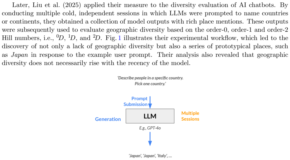
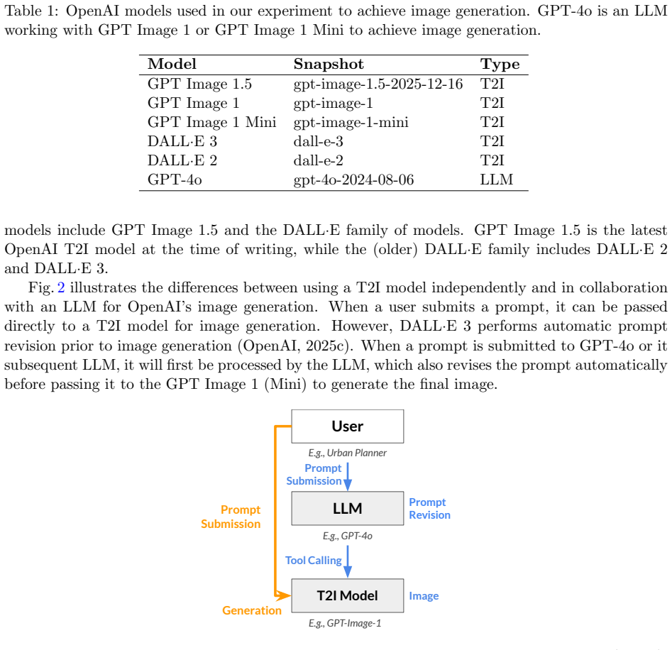
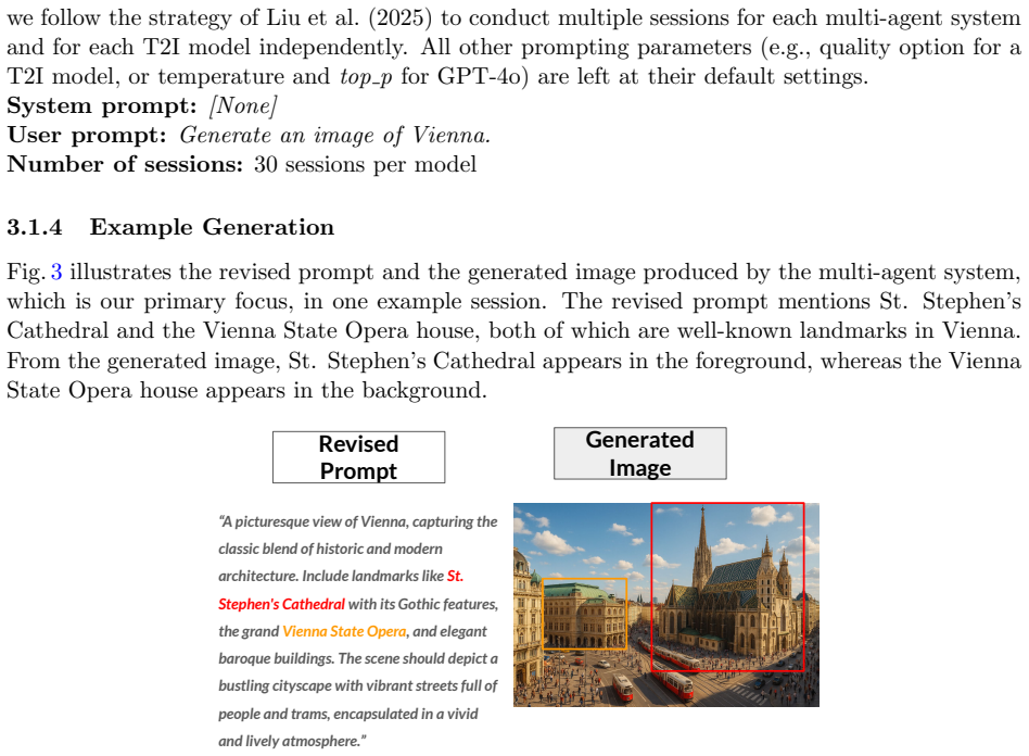
(Gen)AI diversity is not merely an ethical issue. From the perspective of geographic information science (GIScience), it could be interpreted as a function of uncertainty and as a form of cognitive bias, embedded in AI outputs. Recent work has sought to develop information-theoretic diversity measures and apply them to evaluate AI-chatbot outputs in a geographic context. As the AI ecosystem to which we are exposed on a daily basis becomes rapidly multimodal, we believe it is important to examine geographic diversity across various modalities. Focusing on images, this paper aims to fill this research gap. First, we select the GPT and DALL-E models as state-of-the-art examples and point out how assessing their geographic diversity involves various stages, including prompt revision and image generation. Then, taking inspiration from species diversity measures in ecological research, we incorporate similarity weighting into the measurement of geographic diversity. Next, we demonstrate how to evaluate geographic diversity in image generation through a case study. Our analysis reveals several counterintuitive findings. For instance, older models can exhibit greater geographic diversity despite producing lower-quality images, and prompt revision yields greater geographic diversity than image generation. At the same time, we observe explicit model homogeneity underlying the lack of geographic diversity, as the selected models consistently depict the same prototypical geo-specific feature or similar features. This is concerning, as it risks producing stereotypical representations of places.
Editorial analysis
A structured set of objections, weighed in public.
Referee Report
Summary. The paper adapts species-diversity indices from ecology, incorporating similarity weighting, to quantify geographic (platial) diversity in images generated by GPT and DALL-E models. Through a case study involving prompt revision and image generation stages, it reports low geographic diversity overall, with models repeatedly producing the same prototypical geo-specific features (stereotypical representations), alongside counterintuitive results that older models can show higher diversity and that prompt revision increases diversity more than the image-generation step itself.
Significance. If the adapted metrics are shown to validly operationalize platial diversity, the work would contribute to GIScience by extending information-theoretic diversity measures to multimodal AI outputs and by documenting risks of geographic bias and stereotyping in widely used generative models. The empirical focus on real model outputs and the observation of homogeneity are potentially useful for AI ethics and geographic information quality research.
major comments (2)
- [case study / measurement of geographic diversity] Case study / measurement section: the central quantitative claim of low geographic diversity rests on the adapted ecological indices with similarity weighting, yet the manuscript supplies no explicit validation or sensitivity analysis showing that the chosen similarity function (semantic, visual, or geographic) aligns with GIScience concepts of platial distinctiveness rather than generic image similarity; without this, the homogeneity finding risks being an artifact of the metric.
- [analysis / results on model homogeneity] Results / analysis of model homogeneity: the claim that models 'consistently depict the same prototypical geo-specific feature' is load-bearing for the stereotyping conclusion, but the text provides no sample sizes, number of prompts/images per place, inter-rater reliability for qualitative coding, or statistical tests supporting the consistency observation.
minor comments (1)
- [Abstract] Abstract: the summary of counterintuitive findings (older models, prompt revision) would be strengthened by a brief clause indicating the number of models, places, or images examined.
Simulated Author's Rebuttal
We thank the referee for their constructive comments on our manuscript. We address each major comment point by point below, indicating where revisions will be made.
read point-by-point responses
-
Referee: [case study / measurement of geographic diversity] Case study / measurement section: the central quantitative claim of low geographic diversity rests on the adapted ecological indices with similarity weighting, yet the manuscript supplies no explicit validation or sensitivity analysis showing that the chosen similarity function (semantic, visual, or geographic) aligns with GIScience concepts of platial distinctiveness rather than generic image similarity; without this, the homogeneity finding risks being an artifact of the metric.
Authors: We agree that the manuscript would be strengthened by explicit validation of the similarity function. In the revised version, we will add a dedicated subsection describing the rationale for the chosen similarity measure, along with a sensitivity analysis comparing semantic embeddings, visual feature similarity, and geographic distance-based measures. We will also discuss how each aligns (or does not align) with GIScience notions of platial distinctiveness. revision: yes
-
Referee: [analysis / results on model homogeneity] Results / analysis of model homogeneity: the claim that models 'consistently depict the same prototypical geo-specific feature' is load-bearing for the stereotyping conclusion, but the text provides no sample sizes, number of prompts/images per place, inter-rater reliability for qualitative coding, or statistical tests supporting the consistency observation.
Authors: We acknowledge that the current text lacks sufficient detail on these elements. In the revision, we will explicitly report the number of prompts and images generated per place, include inter-rater reliability statistics (e.g., Cohen's kappa) for the qualitative coding of prototypical features, and add appropriate statistical tests (such as tests for proportions or chi-squared tests) to support the consistency claims. revision: yes
Circularity Check
Empirical measurement study applies adapted external metrics with no circular derivation
full rationale
The paper conducts an empirical case study: selecting GPT/DALL-E models, generating images from prompts, and computing geographic diversity via adapted ecological species-diversity indices that incorporate similarity weighting. No derivation chain, first-principles prediction, or fitted parameter is presented whose output is equivalent to its inputs by construction. The abstract and described method cite external ecological measures as inspiration rather than self-referential definitions or load-bearing self-citations. Central claims rest on observed homogeneity in generated images, not on any reduction to prior fitted values or renamed known results.
Axiom & Free-Parameter Ledger
axioms (1)
- domain assumption Ecological species diversity measures can be adapted with similarity weighting to quantify geographic diversity in AI-generated images of places.
Reference graph
Works this paper leans on
-
[1]
A Roadmap to Pluralistic Alignment
A roadmap to pluralistic alignment , author=. arXiv preprint arXiv:2402.05070 , year=
work page internal anchor Pith review Pith/arXiv arXiv
-
[2]
Transactions in GIS , volume =
Liu, Zilong and Janowicz, Krzysztof and Karimi, Mina and Shi, Meilin and Majic, Ivan and Fortacz-Lazan, Alexandra , title =. Transactions in GIS , volume =
-
[3]
The Professional Geographer , volume=
Distortions in judged spatial relations in large language models , author=. The Professional Geographer , volume=. 2024 , publisher=
2024
-
[4]
Proceedings of the 31st ACM International Conference on Advances in Geographic Information Systems , pages=
Are large language models geospatially knowledgeable? , author=. Proceedings of the 31st ACM International Conference on Advances in Geographic Information Systems , pages=
-
[5]
Advance in Environment, Behavior, and Design: Volume 2 , pages=
Environmental perception and cognition , author=. Advance in Environment, Behavior, and Design: Volume 2 , pages=. 1989 , publisher=
1989
-
[6]
Oikos , volume=
Entropy and diversity , author=. Oikos , volume=. 2006 , publisher=
2006
-
[7]
, author=
An information-theoretic definition of similarity. , author=. Icml , volume=
-
[8]
A research agenda for geographic information science , pages=
Cognition of geographic information , author=. A research agenda for geographic information science , pages=. 2004 , publisher=
2004
-
[9]
Transactions in GIS , volume=
The certainty of uncertainty: GIS and the limits of geographic knowledge , author=. Transactions in GIS , volume=. 2003 , publisher=
2003
-
[10]
Cartography and Geographic Information Science , volume=
Deep fake geography? When geospatial data encounter Artificial Intelligence , author=. Cartography and Geographic Information Science , volume=. 2021 , publisher=
2021
-
[11]
On the Opportunities and Risks of Foundation Models
On the opportunities and risks of foundation models , author=. arXiv preprint arXiv:2108.07258 , year=
work page internal anchor Pith review Pith/arXiv arXiv
-
[12]
Proceedings of the 2023 ACM Conference on Fairness, Accountability, and Transparency , pages=
AI’s regimes of representation: A community-centered study of text-to-image models in South Asia , author=. Proceedings of the 2023 ACM Conference on Fairness, Accountability, and Transparency , pages=
2023
-
[13]
Handbook of geospatial artificial intelligence , pages=
Philosophical foundations of geoai: Exploring sustainability, diversity, and bias in geoai and spatial data science , author=. Handbook of geospatial artificial intelligence , pages=. 2023 , publisher=
2023
-
[14]
Proceedings of the 33rd ACM International Conference on Advances in Geographic Information Systems , pages=
Whose Truth? Pluralistic Geo-Alignment for (Agentic) AI , author=. Proceedings of the 33rd ACM International Conference on Advances in Geographic Information Systems , pages=
-
[15]
Proceedings of the 2023 AAAI/ACM Conference on AI, Ethics, and Society , pages=
Social biases through the text-to-image generation lens , author=. Proceedings of the 2023 AAAI/ACM Conference on AI, Ethics, and Society , pages=
2023
-
[16]
Transactions in GIS , volume=
Operationalizing Geographic Diversity for the Evaluation of AI-Generated Content , author=. Transactions in GIS , volume=. 2025 , publisher=
2025
-
[17]
2025 , month = mar, day =
DIALOGPLUS , title =. 2025 , month = mar, day =
2025
-
[18]
Introducing GPT-4o Image Generation , year =
-
[19]
Economic geography , volume=
A computer movie simulating urban growth in the Detroit region , author=. Economic geography , volume=. 1970 , publisher=
1970
-
[20]
ACM Computing Surveys (Csur) , volume=
Knowledge graphs , author=. ACM Computing Surveys (Csur) , volume=. 2021 , publisher=
2021
-
[21]
International Conference on Spatial Information Theory , pages=
A spatial form of diversity , author=. International Conference on Spatial Information Theory , pages=. 2005 , organization=
2005
-
[22]
International Journal of Geographical Information Science , pages=
Foundation models for geospatial reasoning: assessing the capabilities of large language models in understanding geometries and topological spatial relations , author=. International Journal of Geographical Information Science , pages=. 2025 , publisher=
2025
-
[23]
arXiv preprint arXiv:2306.00020 , year=
GPT4GEO: How a language model sees the world's geography , author=. arXiv preprint arXiv:2306.00020 , year=
-
[24]
Ecology , volume=
Diversity and evenness: a unifying notation and its consequences , author=. Ecology , volume=. 1973 , publisher=
1973
-
[25]
Large Language Model based Multi-Agents: A Survey of Progress and Challenges
Large language model based multi-agents: A survey of progress and challenges , author=. arXiv preprint arXiv:2402.01680 , year=
work page internal anchor Pith review Pith/arXiv arXiv
-
[26]
The Bell system technical journal , volume=
A mathematical theory of communication , author=. The Bell system technical journal , volume=. 1948 , publisher=
1948
-
[27]
1964 , publisher=
The image of the city , author=. 1964 , publisher=
1964
-
[28]
IEEE transactions on systems, man, and cybernetics , volume=
Development and application of a metric on semantic nets , author=. IEEE transactions on systems, man, and cybernetics , volume=. 1989 , publisher=
1989
-
[29]
Communications of the ACM , volume=
Wikidata: a free collaborative knowledgebase , author=. Communications of the ACM , volume=. 2014 , publisher=
2014
-
[30]
2025 , url =
Image Generation API Guide (DALL·E 3) , organization =. 2025 , url =
2025
-
[31]
2025 , url =
Image Generation API Guide , organization =. 2025 , url =
2025
-
[32]
2021 , eprint=
High-Resolution Image Synthesis with Latent Diffusion Models , author=. 2021 , eprint=
2021
-
[33]
2025 , month = jun, day =
Mohd Faraaz , title =. 2025 , month = jun, day =
2025
-
[34]
Cognition and categorization , pages=
Principles of categorization , author=. Cognition and categorization , pages=. 2024 , publisher=
2024
-
[35]
Diversity: Its measurement, decomposition, apportionment and analysis , author=. Sankhy. 1982 , publisher=
1982
-
[36]
Proceedings of the 2021 ACM conference on fairness, accountability, and transparency , pages=
On the dangers of stochastic parrots: Can language models be too big? , author=. Proceedings of the 2021 ACM conference on fairness, accountability, and transparency , pages=
2021
-
[37]
Philosophical Studies , pages=
Bias, machine learning, and conceptual engineering , author=. Philosophical Studies , pages=. 2025 , publisher=
2025
-
[38]
No classification without representation: Assessing geodiversity issues in open data sets for the developing world , author=. arXiv preprint arXiv:1711.08536 , year=
work page internal anchor Pith review Pith/arXiv arXiv
-
[39]
Advances in neural information processing systems , volume=
Retrieval-augmented generation for knowledge-intensive nlp tasks , author=. Advances in neural information processing systems , volume=
-
[40]
Proceedings of the 4th Berkeley symposium on mathematics, statistics and probability , volume=
On measures of information and entropy , author=. Proceedings of the 4th Berkeley symposium on mathematics, statistics and probability , volume=
-
[41]
nature , volume=
Measurement of diversity , author=. nature , volume=. 1949 , publisher=
1949
-
[42]
International Journal of Geographical Information Science , volume=
GeoAI: spatially explicit artificial intelligence techniques for geographic knowledge discovery and beyond , author=. International Journal of Geographical Information Science , volume=. 2020 , publisher=
2020
-
[43]
Ecology , volume=
Measuring diversity: the importance of species similarity , author=. Ecology , volume=. 2012 , publisher=
2012
-
[44]
Transactions on Machine Learning Research , year=
Cognitive architectures for language agents , author=. Transactions on Machine Learning Research , year=
-
[45]
and AuthorB, S
AuthorA, F. and AuthorB, S. , title =. International Journal of GIScience , year =
-
[46]
and AuthorD, T
AuthorC, O. and AuthorD, T. and AuthorE, F. , title =. Transactions in GIS , year =
-
[47]
, title =
AuthorE, X. , title =
-
[48]
AGILE - Past Conferences & Proceedings , howpublished =. 2021
2021
-
[49]
2020", editor =
AuthorF, E. and AuthorG, H. and AuthorH, A. and AuthorI, A. , title =. 3rd BIM/GIS Integration Workshop and 15th 3D GeoInfo Conference 2020 , year = "2020", editor = "Wong, K. and Ellul, C. and Morley, J. and Home, R. and Kalantari, M.", volume = "VI-4/W1-2020", pages =
2020
-
[50]
and AuthorG, H
AuthorF, E. and AuthorG, H. and AuthorH, A. and AuthorI, A. , title =. Proceedings of the International Cartographic Association. 2019
2019
discussion (0)
Sign in with ORCID, Apple, or X to comment. Anyone can read and Pith papers without signing in.