Set-Based Transformer for Atmospheric Compensation in Standoff LWIR Hyperspectral Imaging
Pith reviewed 2026-06-27 19:42 UTC · model grok-4.3
The pith
A set-based transformer jointly estimates transmittance, path radiance, and downwelling spectrum from multi-range LWIR radiance measurements.
A machine-rendered reading of the paper's core claim, the machinery that carries it, and where it could break.
Core claim
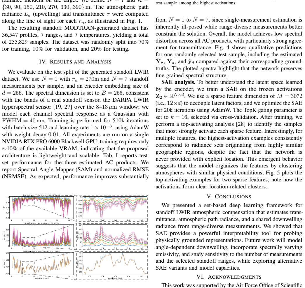
The set-based transformer takes multiple radiance measurements at different standoff ranges as input and jointly estimates transmittance, atmospheric path radiance, and a shared downwelling spectrum, achieving low spectral distortion on a MODTRAN-generated standoff LWIR dataset.
What carries the argument
The lightweight set-based deep learning framework that ingests a variable set of radiance measurements collected at different standoff ranges and produces the three atmospheric quantities together.
If this is right
- Atmospheric compensation becomes feasible without building an explicit physical model for every standoff geometry.
- The same network can process an arbitrary number of range measurements because it treats them as a set.
- Latent features inside the model organize according to geographic coherence without any location supervision.
- The public release of the MODTRAN-generated dataset allows direct comparison of future compensation methods.
Where Pith is reading between the lines
- If the geographic coherence in the latent space holds on real data, the model might support unsupervised scene segmentation or change detection.
- Joint estimation of all three atmospheric terms could reduce cumulative error compared with estimating each term separately.
- The set architecture might generalize to other multi-view or multi-range remote-sensing problems where the number of observations varies.
- Validation on measured field data remains necessary before claiming operational readiness for standoff LWIR systems.
Load-bearing premise
That performance measured on MODTRAN-generated synthetic data serves as a sufficient proxy for performance on real measured field data.
What would settle it
Applying the trained model to actual measured standoff LWIR field data and finding high spectral distortion in the recovered transmittance or radiance products would show the synthetic results do not transfer.
Figures

read the original abstract
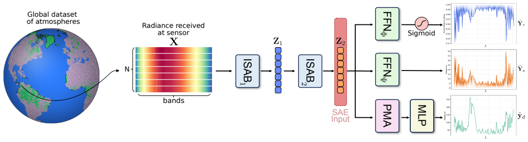
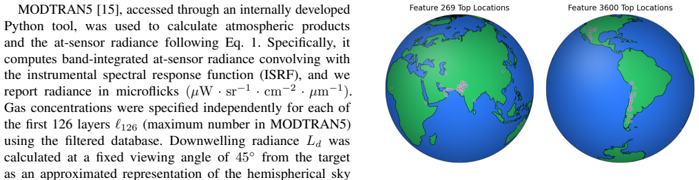
Passive long-wave infrared (LWIR) hyperspectral imaging under a standoff geometry depends on atmospheric absorption and emission, as well as reflected radiance, thus making atmospheric compensation essential to get knowledge of a target of interest. Despite its importance, this compensation has been largely overlooked due to its practical and modeling difficulty. In this paper, we present a lightweight set-based deep learning framework that takes multiple radiance measurements, collected at different standoff ranges, as input and jointly estimates transmittance, atmospheric path radiance, and a shared downwelling spectrum. We analyze the learned representation with a sparse autoencoder and observe that several latent features do activate on geographically coherent subsets of the test data despite the absence of location supervision. Experiments on a MODTRAN generated standoff LWIR dataset demonstrate low spectral distortion across all estimated products. The dataset and code is publicly available at: https://factral.co/SAE-LWIR/
Editorial analysis
A structured set of objections, weighed in public.
Referee Report
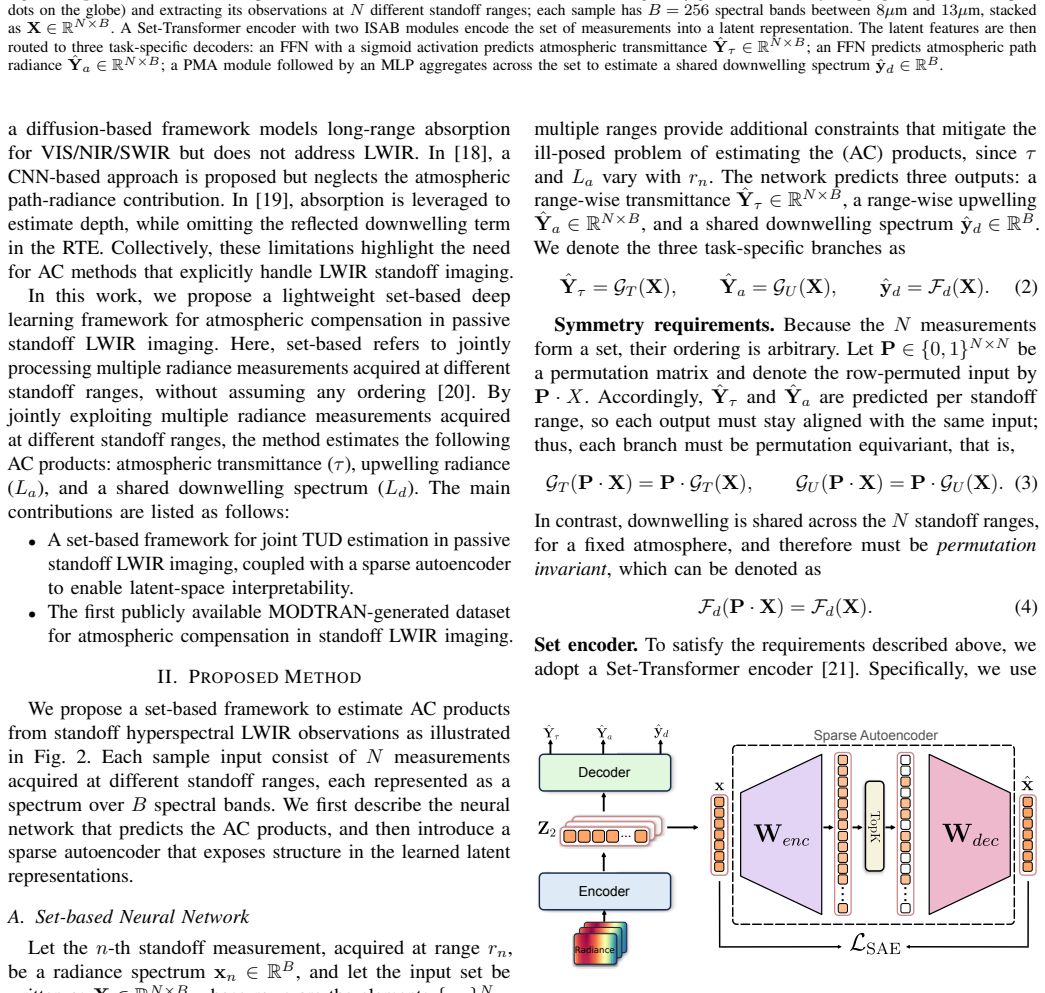
Summary. The manuscript proposes a lightweight set-based transformer that ingests multiple LWIR hyperspectral radiance spectra acquired at different standoff ranges and jointly regresses transmittance, path radiance, and a shared downwelling spectrum. The network is trained in a supervised manner on MODTRAN-generated synthetic standoff data; the authors report low spectral distortion on the estimated products and provide a sparse-autoencoder analysis of the learned latent features. The dataset and code are released publicly.
Significance. Atmospheric compensation remains a practical bottleneck for passive standoff LWIR hyperspectral imaging. A data-driven method that exploits multi-range measurements could be useful if it proves robust. The public release of the MODTRAN dataset and code is a clear positive for reproducibility. However, because all quantitative results rest exclusively on forward-model simulations, the work’s significance for the stated operational application is currently limited.
major comments (2)
- [Abstract / Experiments] Abstract and Experiments section: the headline claim of “low spectral distortion across all estimated products” is supported solely by results on MODTRAN-generated synthetic data under controlled geometries. No quantitative metrics (e.g., RMSE, spectral angle, or band-wise error statistics), architecture hyperparameters, or training protocol appear in the abstract, and no real measured field data are shown. This leaves the transfer from simulation to reality unexamined and makes the central performance claim load-bearing yet unverified for the target application.
- [Abstract / Method] The learned mapping is obtained by supervised regression on external MODTRAN simulations. Consequently, any unmodeled effects present in real passive LWIR measurements (aerosol variability, surface emissivity deviations, sensor calibration drift, etc.) are absent from the training distribution. Without at least one real-data experiment or a clear discussion of domain-shift mitigation, the reported distortion numbers cannot be taken as evidence of operational utility.
minor comments (2)
- The sparse-autoencoder analysis is mentioned but the section, layer dimensions, sparsity penalty, and activation statistics are not described, making it difficult to reproduce or interpret the “geographically coherent” latent features.
- Notation for the set-based input (how the variable number of range measurements is encoded and batched) should be clarified in the methods section.
Simulated Author's Rebuttal
We thank the referee for their constructive feedback. The comments correctly identify that the work relies exclusively on synthetic data, which limits claims of operational utility. We address each point below. We can strengthen the abstract and discussion but cannot add real-data experiments, as none were performed.
read point-by-point responses
-
Referee: [Abstract / Experiments] Abstract and Experiments section: the headline claim of “low spectral distortion across all estimated products” is supported solely by results on MODTRAN-generated synthetic data under controlled geometries. No quantitative metrics (e.g., RMSE, spectral angle, or band-wise error statistics), architecture hyperparameters, or training protocol appear in the abstract, and no real measured field data are shown. This leaves the transfer from simulation to reality unexamined and makes the central performance claim load-bearing yet unverified for the target application.
Authors: We agree the abstract should report concrete metrics and hyperparameters. We will revise it to include average RMSE, spectral angle, and a note on the MODTRAN synthetic training protocol while explicitly stating the data source. The manuscript presents the method and controlled synthetic validation as a proof of concept; real measured field data are outside the current scope. revision: partial
-
Referee: [Abstract / Method] The learned mapping is obtained by supervised regression on external MODTRAN simulations. Consequently, any unmodeled effects present in real passive LWIR measurements (aerosol variability, surface emissivity deviations, sensor calibration drift, etc.) are absent from the training distribution. Without at least one real-data experiment or a clear discussion of domain-shift mitigation, the reported distortion numbers cannot be taken as evidence of operational utility.
Authors: The referee is correct that unmodeled real-world effects are absent. We will expand the discussion section with additional analysis of domain-shift risks and possible mitigation approaches such as domain adaptation or physics-informed regularization. The released dataset and code are intended to support community extensions. The synthetic results still demonstrate the viability of the set-based architecture under the modeled conditions. revision: partial
- Reporting quantitative results on real measured field LWIR hyperspectral data, as the study contains only MODTRAN-generated synthetic data and no real standoff measurements were collected or available.
Circularity Check
No significant circularity; claims rest on supervised training against external MODTRAN benchmark.
full rationale
The paper introduces a set-based transformer that ingests multi-range radiance measurements and outputs estimates of transmittance, path radiance, and downwelling. Training and evaluation occur on a separately generated MODTRAN synthetic dataset; the reported low spectral distortion is therefore an empirical result on held-out external simulations rather than any internal derivation that reduces to fitted parameters or self-citations by construction. No equations, uniqueness theorems, or ansatzes are shown to be smuggled in via self-reference, and the architecture itself is a standard supervised mapping whose outputs are not tautological with its inputs.
Axiom & Free-Parameter Ledger
free parameters (1)
- neural network weights and biases
axioms (1)
- domain assumption MODTRAN-generated synthetic data sufficiently represents the statistics of real standoff LWIR measurements for training and validation purposes.
Reference graph
Works this paper leans on
-
[1]
Atmospheric correction algorithms for hyperspectral remote sensing data of land and ocean,
B.-C. Gao, M. Montes, C. Davis, and A. Goetz, “Atmospheric correction algorithms for hyperspectral remote sensing data of land and ocean,”Remote Sensing of Environment, vol. 113, 09 2009
2009
-
[2]
Longwave infrared hyperspectral imaging: Principles, progress, and challenges,
D. Manolakis, M. Pieper, E. Truslow, R. Lockwood, A. Weisner, J. Jacobson, and T. Cooley, “Longwave infrared hyperspectral imaging: Principles, progress, and challenges,”IEEE Geoscience and Remote Sensing Magazine, vol. 7, no. 2, pp. 72–100, 2019
2019
-
[3]
Making long-wave infrared face recognition robust against image quality degradations,
C. Rodr ´ıguez-Pulecio, H. Ben ´ıtez-Restrepo, and A. Bovik, “Making long-wave infrared face recognition robust against image quality degradations,”Quantitative InfraRed Thermography Journal, vol. 16, no. 3-4, pp. 218–242, Oct. 2019
2019
-
[4]
Person detection in LWIR imagery using image retrieval,
T. M¨uller and D. Manger, “Person detection in LWIR imagery using image retrieval,” inAutomatic Target Recognition XXIII, F. A. Sadjadi and A. Mahalanobis, Eds., vol. 8744, International Society for Optics and Photonics. SPIE, 2013, p. 87440E
2013
-
[5]
Illumination-invariant road detection and tracking using lwir polarization characteristics,
N. Li, Y . Zhao, Q. Pan, S. G. Kong, and J. C.-W. Chan, “Illumination-invariant road detection and tracking using lwir polarization characteristics,”ISPRS Journal of Photogrammetry and Remote Sensing, vol. 180, pp. 357–369, 2021
2021
-
[6]
Automotive sensing: assessing the impact of fog on lwir, mwir, swir, visible, and lidar performance,
K. M. Judd, M. P. Thornton, and A. A. Richards, “Automotive sensing: assessing the impact of fog on lwir, mwir, swir, visible, and lidar performance,” inInfrared Technology and Applications XLV, B. F. Andresen, G. F. Fulop, and C. M. Hanson, Eds., vol. 11002. SPIE: International Society for Optics and Photonics, 2019, p. 110021F
2019
-
[7]
Experimental confirmation of the mwir and lwir grey body assumption for vegetation fire flame emissivity,
J. M. Johnston, M. J. Wooster, and T. J. Lynham, “Experimental confirmation of the mwir and lwir grey body assumption for vegetation fire flame emissivity,”International Journal of Wildland Fire, vol. 23, no. 4, pp. 463–479, 05 2014
2014
-
[8]
Comparison of lithological mapping results from airborne hyperspectral vnir-swir, lwir and combined data,
J. Feng, D. Rogge, and B. Rivard, “Comparison of lithological mapping results from airborne hyperspectral vnir-swir, lwir and combined data,”International Journal of Applied Earth Observation and Geoinformation, vol. 64, pp. 340–353, 2018
2018
-
[9]
LWIR/MWIR imaging hyperspectral sensor for airborne and ground-based remote sensing,
J. A. Hackwell, D. W. Warren, R. P. Bongiovi, S. J. Hansel, T. L. Hayhurst, D. J. Mabry, M. G. Sivjee, and J. W. Skinner, “LWIR/MWIR imaging hyperspectral sensor for airborne and ground-based remote sensing,” inImaging Spectrometry II, M. R. Descour and J. M. Mooney, Eds., vol. 2819, International Society for Optics and Photonics. SPIE, 1996, pp. 102 – 107
1996
-
[10]
Atmo- spheric correction of aster,
K. Thome, F. Palluconi, T. Takashima, and K. Masuda, “Atmo- spheric correction of aster,”IEEE Transactions on Geoscience and Remote Sensing, vol. 36, no. 4, pp. 1199–1211, 1998
1998
-
[11]
In-scene lwir downwelling radiance estimation,
M. Pieper, D. Manolakis, E. Truslow, T. Cooley, M. Brueggeman, A. Weisner, and J. Jacobson, “In-scene lwir downwelling radiance estimation,” inImaging Spectrometry XXI, vol. 9976. SPIE, 2016, pp. 74–92
2016
-
[12]
Retrieval of atmospheric and land surface parameters from satellite-based thermal infrared hyperspectral data using an artificial neural network technique,
M. Chen, L. Ni, X. Jiang, Z. Li, and H. Wu, “Retrieval of atmospheric and land surface parameters from satellite-based thermal infrared hyperspectral data using an artificial neural network technique,” inIGARSS 2018-2018 IEEE International Geoscience and Remote Sensing Symposium. IEEE, 2018, pp. 2745–2748
2018
-
[13]
Multimodal representation learning and set attention for lwir in-scene atmospheric compensation,
N. Westing, K. C. Gross, B. J. Borghetti, C. M. S. Kabban, J. Martin, and J. Meola, “Multimodal representation learning and set attention for lwir in-scene atmospheric compensation,” IEEE Journal of Selected Topics in Applied Earth Observations and Remote Sensing, vol. 14, pp. 127–140, 2020
2020
-
[14]
Oblique in-scene atmospheric compensation,
D. S. O’Keefe, S. N. Nauyoks, M. R. Hawks, J. Meola, and K. C. Gross, “Oblique in-scene atmospheric compensation,”IEEE Transactions on Geoscience and Remote Sensing, vol. 60, pp. 1–15, 2022
2022
-
[15]
Modtran5: A reformulated atmospheric band model with auxiliary species and practical multiple scattering options,
A. Berk, G. P. Anderson, P. K. Acharya, L. S. Bernstein, L. Muratov, J. Lee, M. J. Fox, S. M. Adler-Golden, J. H. Chetwynd Jr, M. L. Hokeet al., “Modtran5: A reformulated atmospheric band model with auxiliary species and practical multiple scattering options,” inAlgorithms and Technologies for Multispectral, Hyperspectral, and Ultraspectral Imagery X, vol
-
[16]
SPIE, 2004, pp. 341–347
2004
-
[17]
Multiple geometry atmospheric correction for image spectroscopy using deep learning,
F. Xu, G. Cervone, G. Franch, and M. Salvador, “Multiple geometry atmospheric correction for image spectroscopy using deep learning,”Journal of Applied Remote Sensing, vol. 14, no. 2, pp. 024 518–024 518, 2020
2020
-
[18]
Atmospheric correction using diffusion models and modtran for constrained training,
D. Stelter, E. Brewer, and R. Sundberg, “Atmospheric correction using diffusion models and modtran for constrained training,” inAlgorithms, Technologies, and Applications for Multispectral and Hyperspectral Imaging XXX, vol. 13031. SPIE, 2024, pp. 93–102
2024
-
[19]
Heat-assisted detection and ranging,
F. Bao, X. Wang, S. H. Sureshbabu, G. Sreekumar, L. Yang, V . Aggarwal, V . N. Boddeti, and Z. Jacob, “Heat-assisted detection and ranging,”Nature, vol. 619, no. 7971, pp. 743– 748, 2023
2023
-
[20]
Absorption-based, passive range imaging from hyperspectral thermal measurements,
U. Dorken Gallastegi, H. Rueda-Chac ´on, M. J. Stevens, and V . K. Goyal, “Absorption-based, passive range imaging from hyperspectral thermal measurements,”IEEE Transactions on Pattern Analysis and Machine Intelligence, vol. 47, no. 5, pp. 4044–4060, 2025
2025
-
[21]
Deep sets,
M. Zaheer, S. Kottur, S. Ravanbakhsh, B. Poczos, R. R. Salakhutdinov, and A. J. Smola, “Deep sets,” inAdvances in Neural Information Processing Systems, I. Guyon, U. V . Luxburg, S. Bengio, H. Wallach, R. Fergus, S. Vishwanathan, and R. Garnett, Eds., vol. 30. Curran Associates, Inc., 2017
2017
-
[22]
Set transformer: A framework for attention-based permutation- invariant neural networks,
J. Lee, Y . Lee, J. Kim, A. Kosiorek, S. Choi, and Y . W. Teh, “Set transformer: A framework for attention-based permutation- invariant neural networks,” inInternational Conference on Machine Learning. ICML, 2019, pp. 3744–3753
2019
-
[23]
Attention is all you need,
A. Vaswani, N. Shazeer, N. Parmar, J. Uszkoreit, L. Jones, A. N. Gomez, Ł. Kaiser, and I. Polosukhin, “Attention is all you need,” Advances in Neural Information Processing Systems, vol. 30, 2017
2017
-
[24]
J. L. Ba, J. R. Kiros, and G. E. Hinton, “Layer normalization,” arXiv preprint arXiv:1607.06450, 2016
work page internal anchor Pith review Pith/arXiv arXiv 2016
-
[25]
Gaussian Error Linear Units (GELUs)
D. Hendrycks, “Gaussian error linear units (gelus),”arXiv preprint arXiv:1606.08415, 2016
work page internal anchor Pith review Pith/arXiv arXiv 2016
-
[26]
A. Makhzani and B. Frey, “K-sparse autoencoders,”arXiv preprint arXiv:1312.5663, 2013
work page internal anchor Pith review Pith/arXiv arXiv 2013
-
[27]
A comprehensive clear-sky database for the development of land surface temperature algorithms,
S. L. Ermida and I. F. Trigo, “A comprehensive clear-sky database for the development of land surface temperature algorithms,”Remote Sensing, vol. 14, no. 10, 2022
2022
-
[28]
Concur- rent band selection and traversability estimation from long-wave hyperspectral imagery in off-road settings,
F. Yellin, S. McCloskey, C. Hill, E. Smith, and B. Clipp, “Concur- rent band selection and traversability estimation from long-wave hyperspectral imagery in off-road settings,” inProceedings of the IEEE/CVF Winter Conference on Applications of Computer Vision, 2024, pp. 7483–7492
2024
-
[29]
Scaling and evaluating sparse autoencoders,
L. Gao, T. D. la Tour, H. Tillman, G. Goh, R. Troll, A. Radford, I. Sutskever, J. Leike, and J. Wu, “Scaling and evaluating sparse autoencoders,” inThe Thirteenth International Conference on Learning Representations, 2025
2025
discussion (0)
Sign in with ORCID, Apple, or X to comment. Anyone can read and Pith papers without signing in.