Active Perception for Radio Map Reconstruction in Uncharted 3D Air-Ground Environments
Pith reviewed 2026-06-27 06:09 UTC · model grok-4.3
The pith
A two-stage framework decouples radio map recovery from active exploration to cut reconstruction error by more than half in unknown 3D air-ground spaces.
A machine-rendered reading of the paper's core claim, the machinery that carries it, and where it could break.
Core claim
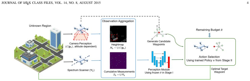
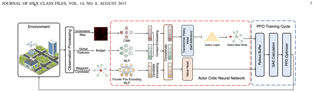
The paper claims that 3D uncertainty aware radio active mapping (3D-URAM) recovers radio maps from sparse measurements and partial geometry by first applying a Bayesian UNet that supplies calibrated predictive uncertainty, then employing a dynamic probabilistic roadmap together with a transformer-based waypoint selector trained by proximal policy optimization to maximize long-horizon uncertainty reduction inside a travel budget.
What carries the argument
The Bayesian UNet supplies per-voxel uncertainty estimates that drive a transformer policy selecting waypoints on a dynamic probabilistic roadmap; together they close the loop between measurement and next move.
If this is right
- Reconstruction error drops by more than 50 percent relative to representative baselines under the same measurement budget.
- The same trained policy can be deployed without retraining across different radio environments provided the uncertainty estimates remain reliable.
- Power-constrained UAVs can still produce usable maps because the policy explicitly respects travel budgets while chasing uncertainty reduction.
- Real-world validation inside a 300 m by 200 m by 100 m volume confirms that the two-stage pipeline functions end-to-end on physical hardware.
Where Pith is reading between the lines
- If the uncertainty calibration holds only inside the training distribution, the method may require periodic fine-tuning when propagation conditions change with weather or new buildings.
- The same uncertainty-driven selection loop could be transferred to other sparse-sensing tasks such as thermal or chemical mapping once a suitable Bayesian predictor is substituted.
- Because the roadmap is rebuilt dynamically, the planner may naturally avoid no-fly zones or obstacles without an explicit safety layer if the uncertainty map already encodes them.
Load-bearing premise
The offline-trained Bayesian UNet will continue to output well-calibrated uncertainty values when it encounters real radio-propagation conditions and geometries it never saw during training.
What would settle it
A side-by-side flight test in a new 300 m by 200 m by 100 m outdoor volume where the active method produces final map error no lower than the best non-active baseline would falsify the central performance claim.
Figures


read the original abstract
Radio maps provide the essential foundation for low altitude networking systems. Unlike terrestrial radio maps that are typically generated via drive test measurements, mapping the air-ground environment requires the deployment of unmanned aerial vehicles (UAVs). This shift introduces two formidable challenges in uncharted 3D scenarios. First, sparse radio measurements and incomplete geometric observations hinder accurate reconstruction. Second, the large 3D action space and strict power constraints from high spectrum scanner energy consumption make informative exploration difficult. To address these issues, this paper proposes 3D uncertainty aware radio active mapping (3D-URAM), a closed loop active perception framework that decouples the mapping process into two offline trained stages. In Stage I, a Bayesian UNet is developed to recover radio maps from sparse measurements and partial geometry while providing calibrated predictive uncertainty. In Stage II, a dynamic probabilistic roadmap and a transformer based waypoint selection policy trained via proximal policy optimization maximize long horizon uncertainty reduction under travel budgets. Experimental results demonstrate that 3D-URAM reduces reconstruction error by over 50% compared to representative baselines. Real-world field tests within a 300mx200mx100m space also validate the potential of active radio map reconstruction.
Editorial analysis
A structured set of objections, weighed in public.
Referee Report
Summary. The manuscript proposes 3D-URAM, a closed-loop active perception framework for radio map reconstruction in uncharted 3D air-ground environments. It decouples the task into two offline-trained stages: (I) a Bayesian UNet that reconstructs radio maps from sparse measurements and partial geometry while producing calibrated predictive uncertainty, and (II) a dynamic probabilistic roadmap combined with a transformer-based waypoint selection policy trained via PPO to maximize long-horizon uncertainty reduction under travel and power budgets. The central claims are a >50% reduction in reconstruction error versus representative baselines and successful real-world validation in a 300 m × 200 m × 100 m volume.
Significance. If the experimental claims are substantiated with proper controls, the work would advance practical UAV-based radio mapping for low-altitude networks by addressing sparse sampling and energy constraints through uncertainty-guided exploration. The offline-training decoupling is a pragmatic design choice that could facilitate deployment.
major comments (2)
- [Abstract] Abstract: the claim of >50% error reduction and real-world validation is presented without any reference to baseline methods, statistical significance tests, error bars, dataset sizes, or ablation on post-hoc design choices; this directly undermines verifiability of the central performance claim.
- The load-bearing assumption that the offline-trained Bayesian UNet yields well-calibrated uncertainty estimates that transfer to real propagation, geometry, and sensor conditions (thereby enabling reliable PPO waypoint selection) receives no supporting evidence such as reliability diagrams or expected calibration error on the field-test data; if miscalibrated, the closed-loop exploration guarantee collapses.
minor comments (1)
- [Abstract] The notation '300mx200mx100m' should be written with proper multiplication symbols and units for clarity.
Simulated Author's Rebuttal
We thank the referee for their thoughtful comments, which help improve the clarity and rigor of our work. Below we provide point-by-point responses to the major comments.
read point-by-point responses
-
Referee: [Abstract] Abstract: the claim of >50% error reduction and real-world validation is presented without any reference to baseline methods, statistical significance tests, error bars, dataset sizes, or ablation on post-hoc design choices; this directly undermines verifiability of the central performance claim.
Authors: The abstract is intended as a concise summary and adheres to typical length limits, which preclude including all methodological and statistical details. The full manuscript substantiates the >50% error reduction claim through comparisons against representative baselines (detailed in Section IV-B), with error bars from repeated experiments, statistical significance tests reported in Table II, dataset sizes specified in Section IV-A, and ablations on design choices in Section V. These elements ensure verifiability. If desired, we can append a short phrase to the abstract referencing the experimental sections. revision: partial
-
Referee: The load-bearing assumption that the offline-trained Bayesian UNet yields well-calibrated uncertainty estimates that transfer to real propagation, geometry, and sensor conditions (thereby enabling reliable PPO waypoint selection) receives no supporting evidence such as reliability diagrams or expected calibration error on the field-test data; if miscalibrated, the closed-loop exploration guarantee collapses.
Authors: Calibration of the Bayesian UNet is demonstrated on the simulation data via reliability diagrams and expected calibration error (ECE) metrics presented in Figure 3. The real-world field tests in a 300m×200m×100m volume (Section VI) show that the uncertainty-aware policy achieves superior reconstruction performance, providing indirect support for the transfer of the uncertainty estimates. We concur that direct calibration assessment on field data would strengthen the argument. Accordingly, we will compute and include reliability diagrams and ECE values using the real sensor measurements in the revised manuscript. revision: yes
Circularity Check
No significant circularity; results from offline training and separate experimental validation
full rationale
The provided abstract and context describe a two-stage framework (Bayesian UNet for map recovery + uncertainty, then PPO-trained policy for exploration) whose performance is asserted via experimental comparison to baselines and real-world field tests. No equations, derivations, or self-citations are present that would reduce any claimed prediction or uniqueness result to fitted inputs by construction. The central claims rest on empirical error reduction rather than any load-bearing self-definition, fitted-input-as-prediction, or imported uniqueness theorem. This is the common case of a self-contained empirical ML pipeline with no circular reduction.
Axiom & Free-Parameter Ledger
Reference graph
Works this paper leans on
-
[1]
Bayesian-Driven Graph Reasoning for Active Radio Map Con- struction,
W. Lu, S. Gao, M. Wen, Y . Liang, L. Yang, C.-B. Chae, and H. V . Poor, “Bayesian-Driven Graph Reasoning for Active Radio Map Con- struction,” in2025 Seventeenth International Conference on Wireless Communications and Signal Processing (WCSP), Chongqing, China, Oct. 2025
2025
-
[2]
A Tutorial on Environment-Aware Communications via Channel Knowledge Map for 6G,
Y . Zeng, J. Chen, J. Xu, D. Wu, X. Xu, S. Jin, X. Gao, D. Gesbert, S. Cui, and R. Zhang, “A Tutorial on Environment-Aware Communications via Channel Knowledge Map for 6G,”IEEE Communications Surveys & Tutorials, vol. 26, no. 3, pp. 1478–1519, Thirdquarter 2024
2024
-
[3]
Automatic Radio Map Adaptation for Indoor Localization Using Smartphones,
C. Wu, Z. Yang, and C. Xiao, “Automatic Radio Map Adaptation for Indoor Localization Using Smartphones,”IEEE Transactions on Mobile Computing, vol. 17, no. 3, pp. 517–528, Mar. 2018
2018
-
[4]
Indoor Localization and Radio Map Estimation Using Unsupervised Manifold Alignment with Geometry Perturbation,
K. Majeed, S. Sorour, T. Y . Al-Naffouri, and S. Valaee, “Indoor Localization and Radio Map Estimation Using Unsupervised Manifold Alignment with Geometry Perturbation,”IEEE Transactions on Mobile Computing, vol. 15, no. 11, pp. 2794–2808, Nov. 2016
2016
-
[5]
Radio Envi- ronment Map Based Inter-Cell Interference Coordination for Massive- MIMO Systems,
W. B. Chikha, M. Masson, Z. Altman, and S. B. Jemaa, “Radio Envi- ronment Map Based Inter-Cell Interference Coordination for Massive- MIMO Systems,”IEEE Transactions on Mobile Computing, vol. 23, no. 1, pp. 785–796, Jan. 2024
2024
-
[6]
Cellular-Enabled UA V Communica- tion: A Connectivity-Constrained Trajectory Optimization Perspective,
S. Zhang, Y . Zeng, and R. Zhang, “Cellular-Enabled UA V Communica- tion: A Connectivity-Constrained Trajectory Optimization Perspective,” IEEE Transactions on Communications, vol. 67, no. 3, pp. 2580–2604, Mar. 2019
2019
-
[7]
On the Use of Radio Environment Maps for Interference Management in Heterogeneous Networks,
J. Perez-Romero, A. Zalonis, L. Boukhatem, A. Kliks, K. Koutlia, N. Dimitriou, and R. Kurda, “On the Use of Radio Environment Maps for Interference Management in Heterogeneous Networks,”IEEE Communications Magazine, vol. 53, no. 8, pp. 184–191, Aug. 2015
2015
-
[8]
Integrated Sensing, Communication, and Computation for Low-Altitude Networks Towards Seamless Connectivity and Connected Intelligence,
S. Gao, J. Yan, P. Huang, Z. Lu, M. Gong, L. Miao, G. Zhu, J. Liang, and L. Yang, “Integrated Sensing, Communication, and Computation for Low-Altitude Networks Towards Seamless Connectivity and Connected Intelligence,”IEEE Internet of Things Magazine, pp. 1–9, 2026
2026
-
[9]
Large Timescale Optimization for Communications Over Aerial Ad Hoc Networks With Predetermined Trajectories,
B. Li and J. Chen, “Large Timescale Optimization for Communications Over Aerial Ad Hoc Networks With Predetermined Trajectories,”IEEE Transactions on Communications, vol. 72, no. 10, pp. 6371–6385, Oct. 2024
2024
-
[10]
Radio Map Estimation: A Data-driven Approach to Spectrum Cartography,
D. Romero and S.-J. Kim, “Radio Map Estimation: A Data-driven Approach to Spectrum Cartography,”IEEE Signal Processing Magazine, vol. 39, no. 6, pp. 53–72, Nov. 2022
2022
-
[11]
3D Radio Map Recon- struction Based on Generative Adversarial Networks Under Constrained Aircraft Trajectories,
T. Hu, Y . Huang, J. Chen, Q. Wu, and Z. Gong, “3D Radio Map Recon- struction Based on Generative Adversarial Networks Under Constrained Aircraft Trajectories,”IEEE Transactions on Vehicular Technology, vol. 72, no. 6, pp. 8250–8255, Jun. 2023
2023
-
[12]
Sionna: An open-source library for next-generation physical layer research,
J. Hoydis, S. Cammerer, F. A. Aoudia, A. Vem, N. Binder, G. Marcus, and A. Keller, “Sionna: An Open-Source Library for Next-Generation Physical Layer Research,” 2023. [Online]. Available: https://arxiv.org/abs/2203.11854
-
[13]
Empow- ering Wireless Network Applications with Deep Learning-Based Radio Propagation Models,
S. Bakirtzis, C ¸ . Yapar, M. Fiore, J. Zhang, and I. Wassell, “Empow- ering Wireless Network Applications with Deep Learning-Based Radio Propagation Models,”IEEE Wireless Communications, vol. 32, no. 4, pp. 124–131, Aug. 2025
2025
-
[14]
Kriging-Based Interference Power Constraint: Integrated Design of the Radio Environment Map and Transmission Power,
K. Sato and T. Fujii, “Kriging-Based Interference Power Constraint: Integrated Design of the Radio Environment Map and Transmission Power,”IEEE Transactions on Cognitive Communications and Network- ing, vol. 3, no. 1, pp. 13–25, Mar. 2017
2017
-
[15]
Propagation Map Reconstruction via Interpolation Assisted Matrix Completion,
H. Sun and J. Chen, “Propagation Map Reconstruction via Interpolation Assisted Matrix Completion,”IEEE Transactions on Signal Processing, vol. 70, pp. 6154–6169, 2022
2022
-
[16]
Cressie,Statistics for Spatial Data
N. Cressie,Statistics for Spatial Data. Hoboken, NJ, USA: Wiley- Interscience, 1993
1993
-
[17]
Deep Completion Autoencoders for Radio Map Estimation,
Y . Teganya and D. Romero, “Deep Completion Autoencoders for Radio Map Estimation,”IEEE Transactions on Wireless Communications, vol. 21, no. 3, pp. 1710–1724, Mar. 2022
2022
-
[18]
RadioUNet: Fast Radio Map Estimation With Convolutional Neural Networks,
R. Levie, C ¸ . Yapar, G. Kutyniok, and G. Caire, “RadioUNet: Fast Radio Map Estimation With Convolutional Neural Networks,”IEEE Transactions on Wireless Communications, vol. 20, no. 6, pp. 4001– 4015, Jun. 2021
2021
-
[19]
RME-GAN: A Learning Framework for Radio Map Estimation Based on Conditional Generative Adversarial Network,
S. Zhang, A. Wijesinghe, and Z. Ding, “RME-GAN: A Learning Framework for Radio Map Estimation Based on Conditional Generative Adversarial Network,”IEEE Internet of Things Journal, vol. 10, no. 20, pp. 18 016–18 027, Oct. 2023
2023
-
[20]
A Graph Neural Network Based Radio Map Construction Method for Urban Environment,
G. Chen, Y . Liu, T. Zhang, J. Zhang, X. Guo, and J. Yang, “A Graph Neural Network Based Radio Map Construction Method for Urban Environment,”IEEE Communications Letters, vol. 27, no. 5, pp. 1327– 1331, May 2023
2023
-
[21]
Temporal Spectrum Cartography in Low-Altitude Economy Networks: A Generative AI Framework With Multi-Agent Learning,
C. Zhao, R. Zhang, J. Wang, D. Niyato, G. Sun, H. Du, Z. Li, A. Jamalipour, and D. I. Kim, “Temporal Spectrum Cartography in Low-Altitude Economy Networks: A Generative AI Framework With Multi-Agent Learning,”IEEE Transactions on Mobile Computing, pp. 1–17, 2025
2025
-
[22]
Denoising Diffusion Probabilistic Model for Radio Map Estimation in Generative Wireless Networks,
X. Luo, Z. Li, Z. Peng, M. Chen, and Y . Liu, “Denoising Diffusion Probabilistic Model for Radio Map Estimation in Generative Wireless Networks,”IEEE Transactions on Cognitive Communications and Net- working, vol. 11, no. 2, pp. 751–763, Apr. 2025
2025
-
[23]
RadioDiff: An Effective Generative Diffusion Model for Sampling-Free Dynamic Radio Map Construction,
X. Wang, K. Tao, N. Cheng, Z. Yin, Z. Li, Y . Zhang, and X. Shen, “RadioDiff: An Effective Generative Diffusion Model for Sampling-Free Dynamic Radio Map Construction,”IEEE Transactions on Cognitive Communications and Networking, vol. 11, no. 2, pp. 738–750, Apr. 2025
2025
-
[24]
Spectrum Surveying: Active Radio Map Estimation with Autonomous UA Vs,
R. Shrestha, D. Romero, and S. P. Chepuri, “Spectrum Surveying: Active Radio Map Estimation with Autonomous UA Vs,”IEEE Transactions on Wireless Communications, vol. 22, no. 1, pp. 627–641, Jan. 2023
2023
-
[25]
Bayesian Active Learning for Sample Efficient 5G Radio Map Reconstruction,
K. D. Polyzos, A. Sadeghi, W. Ye, S. Sleder, K. Houssou, J. Calder, Z.- L. Zhang, and G. B. Giannakis, “Bayesian Active Learning for Sample Efficient 5G Radio Map Reconstruction,”IEEE Transactions on Wireless Communications, vol. 23, no. 12, pp. 19 382–19 396, Dec. 2024
2024
-
[26]
UA V-Aided Efficient Informative Path Planning for Autonomous 3D Spectrum Mapping,
Y . Chen, Q. Zhu, J. Wang, Z. Jia, X. Wang, Z. Lin, Y . Huang, Q. Wu, and C. Briso-Rodr´ıguez, “UA V-Aided Efficient Informative Path Planning for Autonomous 3D Spectrum Mapping,”IEEE Transactions on Cognitive Communications and Networking, vol. 12, pp. 1664–1677, 2026
2026
-
[27]
Online Radio Environment Map Cre- ation via UA V Vision for Aerial Networks,
N. C. Matson and K. Sundaresan, “Online Radio Environment Map Cre- ation via UA V Vision for Aerial Networks,” in2024 IEEE Conference on Computer Communications (INFOCOM), Vancouver, BC, Canada, 2024, pp. 81–90
2024
-
[28]
Receding Horizon
A. Bircher, M. Kamel, K. Alexis, H. Oleynikova, and R. Siegwart, “Receding Horizon ”Next-Best-View” Planner for 3D Exploration,” in2016 IEEE International Conference on Robotics and Automation (ICRA), Stockholm, Sweden, 2016
2016
-
[29]
Planet dump retrieved from https://planet.osm.org ,
OpenStreetMap contributors, “Planet dump retrieved from https://planet.osm.org ,” https://www.openstreetmap.org, 2017
2017
-
[30]
Radio Map Prediction From Aerial Images and Application to Coverage Optimization,
F. Jaensch, G. Caire, and B. Demir, “Radio Map Prediction From Aerial Images and Application to Coverage Optimization,”IEEE Transactions on Wireless Communications, vol. 25, pp. 308–320, 2026
2026
-
[31]
Deep Reinforcement Learning with Dynamic Graphs for Adaptive Informative Path Planning,
A. Vashisth, J. R ¨uckin, F. Magistri, C. Stachniss, and M. Popovic, “Deep Reinforcement Learning with Dynamic Graphs for Adaptive Informative Path Planning,”IEEE Robotics and Automation Letters (RA-L), pp. 1–8, Sep. 2024
2024
-
[32]
SIP2Net: Situational-Aware Indoor Pathloss-Map Prediction Network for Radio Map Generation,
W. Lu, Z. Lu, J. Yan, and S. Gao, “SIP2Net: Situational-Aware Indoor Pathloss-Map Prediction Network for Radio Map Generation,” in2025 IEEE International Conference on Acoustics, Speech and Signal Pro- cessing (ICASSP), Hyderabad, India, 2025
2025
-
[33]
Dropout as a Bayesian Approximation: Representing Model Uncertainty in Deep Learning
Y . Gal and Z. Ghahramani, “Dropout as a Bayesian Approximation: Representing Model Uncertainty in Deep Learning,” 2016. [Online]. Available: https://arxiv.org/abs/1506.02142
work page internal anchor Pith review Pith/arXiv arXiv 2016
-
[35]
Proximal Policy Optimization Algorithms
[Online]. Available: http://arxiv.org/abs/1707.06347
work page internal anchor Pith review Pith/arXiv arXiv
-
[36]
Stochastic Variational Deep Kernel Learning,
A. G. Wilson, Z. Hu, R. R. Salakhutdinov, and E. P. Xing, “Stochastic Variational Deep Kernel Learning,” inProc. Advances in Neural Infor- mation Processing Systems, vol. 29, 2016
2016
-
[37]
The CMA Evolution Strategy: A Tutorial
N. Hansen, “The CMA Evolution Strategy: A Tutorial,”CoRR, vol. abs/1604.00772, 2016. [Online]. Available: http://arxiv.org/abs/1604. 00772
work page internal anchor Pith review Pith/arXiv arXiv 2016
-
[38]
Monte Carlo Tree Search: A Review of Recent Modifications and Applications,
M. Swiechowski, K. Godlewski, B. Sawicki, and J. Mandziuk, “Monte Carlo Tree Search: A Review of Recent Modifications and Applications,”CoRR, vol. abs/2103.04931, 2021. [Online]. Available: https://arxiv.org/abs/2103.04931
discussion (0)
Sign in with ORCID, Apple, or X to comment. Anyone can read and Pith papers without signing in.