REVIEW 4 major objections 5 minor 38 references
fabSAM: A Farmland Boundary Delineation Method Based on the Segment Anything Model
T0 review · 4 major / 5 minor · reviewed 2026-08-10 · deepseek-v4-flash
Pith's one-line read A Deeplabv3+-based prompter feeding mask and point prompts into fine-tuned SAM decoders improves farmland boundary delineation by up to 23 percentage points on two benchmarks.
desk verdict A competent SAM-based farmland delineation pipeline with honest self-assessment, but the headline mIOU gains rest on a single split and an ambiguous crop-level protocol, so the numbers are not yet trustworthy. read the letter →
The pith
A machine-rendered reading of the paper's core claim, the machinery that carries it, and where it could break.
The reading
What carries the argument
The load-bearing mechanism is the prompt pathway from Deeplabv3+ to SAM. Deeplabv3+ predicts a farmland logit map; that map is fed to SAM's prompt encoder as a mask prompt, and a sampler converts the sigmoid probability map into point prompts, choosing foreground pixels with probability above 0.7, background pixels below 0.3, and favoring higher-confidence pixels. SAM's frozen image encoder supplies high-level visual features, and two separately fine-tuned decoders combine those features with the prompt embeddings to output region and boundary masks. A post-processor takes the symmetric difference between the two masks to produce closed parcel boundaries. The design lets any segmentation model be reused as an automatic prompt generator and treats SAM's block as a trainable post-processor.
What would settle it
Take a third Sentinel-2 farmland region not represented in AI4B or AI4S, run fabSAM and Deeplabv3+ over several random seeds, and compare boundary IoU; if the gap is within seed noise or reverses, then the reported gains are tied to the two benchmark distributions rather than to the architecture.
Extended reading notes
Core claim
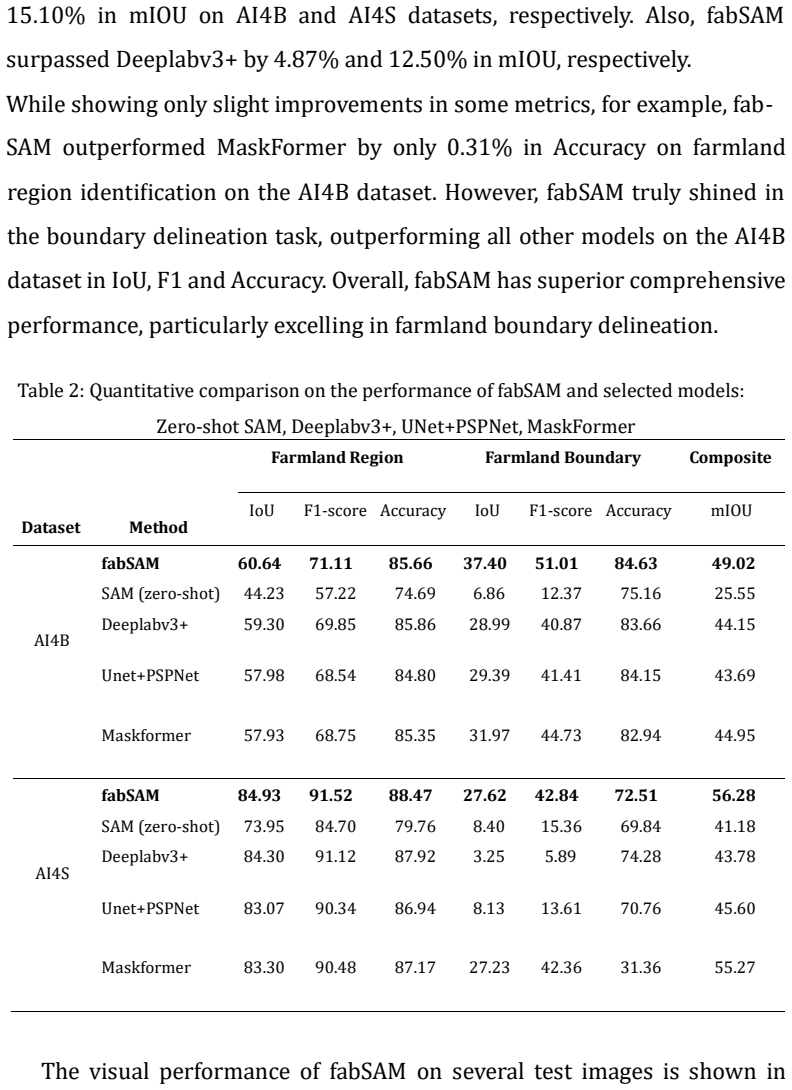
fabSAM's central claim is that a classical segmentation model can act as an automatic prompt generator for SAM, and that fine-tuning SAM's prompt encoder and two lightweight decoders on those prompts yields better farmland region and boundary masks than either the prompter or zero-shot SAM alone. The prompter is Deeplabv3+; its logits are used directly as a mask prompt, and a point generator samples reliable foreground pixels (probability above 0.7) and background pixels (below 0.3) from the sigmoid of those logits. The SAM image encoder is kept frozen, while the mask decoder and boundary decoder are trained separately with a Dice-plus-Focal loss. On the AI4Boundaries and AI4SmallFarms benchmarks this improves mIOU by 23.47 and 15.10 points over zero-shot SAM and by 4.87 and 12.50 points over Deeplabv3+, with the largest absolute improvement in boundary IoU. The paper further claims this is the first hybrid architecture to combine a mask-prompt generator with a SAM-based block specifically for farmland boundary delineation.
Load-bearing premise
The whole method inherits the errors of its initial Deeplabv3+ stage: if that stage misses an area of farmland, the SAM block only refines the prompts it receives and cannot recover the missed area.
Editorial extensions
If this is right
- Farmland region and boundary maps can be generated automatically from 10-meter Sentinel-2 imagery without human annotation, which supports crop monitoring and agricultural census at large scale.
- The approach generalizes beyond farmland: any task where a classical segmenter produces rough masks can use the same mask-and-point prompt recipe to sharpen outputs with a fine-tuned SAM decoder.
- Boundary delineation, not just region overlap, is where the hybrid method pays off, so precision-agriculture applications that need parcel perimeters gain the most.
- Separate decoders for region and boundary with task-specific fine-tuning allow each objective to be optimized without compromising the other.
- On the AI4SmallFarms benchmark, boundary IoU improves from 3.25 with Deeplabv3+ to 27.62 with fabSAM, suggesting the method is especially useful in fragmented smallholder landscapes.
Reading between the lines
- Because the paper reports a single train/validation/test split, a fair reading is that the headline margins are untested for variance; a natural extension is to rerun with several seeds and report error bars.
- The ablation suggests the point prompt contributes about twice as much as the mask prompt, so a prompt generator optimized for reliable foreground and background points may matter more than denser masks.
- The stated Prompter bottleneck implies fabSAM's gains should scale with Prompter quality: pairing the same SAM block with a stronger or domain-adapted segmenter is a cheap testable path to further improvement.
- Since SAM's image encoder is frozen at its native patch size, applying fabSAM to very high-resolution imagery may require a boundary-refinement decoder or tiling, a limitation the paper does not address.
Editorial analysis
A structured set of objections, weighed in public.
Referee Report
Summary. The paper proposes fabSAM, a two-block framework for farmland boundary delineation from satellite imagery. A Deeplabv3+-based Prompter generates mask and point prompts, which are fed into a SAM-based block with a frozen image encoder, a fine-tuned prompt encoder, and two separately fine-tuned mask decoders for region identification and boundary delineation. The method is evaluated on the AI4Boundaries (AI4B) and AI4SmallFarms (AI4S) datasets. The abstract and Section 4.4.1 report mIOU improvements of 23.47% and 15.10% over zero-shot SAM, and 4.87% and 12.50% over Deeplabv3+, respectively. The paper also claims to be the first to combine a mask-prompt generator with a SAM-based block for this task.
Significance. The proposed architecture is simple and pragmatic: it reuses SAM's strong image features and adds lightweight, task-specific decoders, which is a promising recipe for remote sensing segmentation. The boundary IoU gains, if reproducible, would be practically useful for parcel mapping from open Sentinel-2 data. The paper also honestly discloses in Section 4.4.2 that accuracy depends mainly on the Prompter and that fragmented farmland is missed, which is a genuine limitation. The central weakness is that the quantitative evidence is not statistically anchored: there is a single data split, no error bars, and the crop-level preprocessing raises a potential leakage concern. These issues must be resolved before the headline improvements can be accepted.
major comments (4)
- [Section 4.1] The manuscript states that images were cropped to 256×256 pixels and then split 70/15/15, but it does not state whether the split was performed at the level of the original scenes or at the crop level. If crops from the same large scene appear in both the training and test sets, the model can memorize local parcel geometry rather than learning transferable boundary delineation, which would particularly inflate the boundary IoU values in Table 2. Please clarify the split protocol and, if the split is at the crop level, repeat the evaluation with a scene-level split or provide evidence that the reported gains persist.
- [Table 2 / Section 4.4.1] The reported mIOU improvements are single-run point estimates without error bars, confidence intervals, or multiple seeds. This is a load-bearing issue because Section 3.1 introduces stochastic point-prompt generation and the fine-tuning involves random initialization, so the 4.87% and 12.50% gains over Deeplabv3+ may not be stable. Please provide at least three independent runs with mean and standard deviation, or a paired statistical test, for the key comparisons in Table 2.
- [Section 3.1] The point-prompt probability thresholds (0.7 for foreground, 0.3 for background) are described as 'selected based on the experiment results' without specifying which data were used for this selection. If the test split was used to choose these thresholds, the comparison in Table 2 is partially circular. Please state explicitly that the thresholds were chosen on the validation split only, and report the sensitivity of the results to these values.
- [Abstract and Section 4.4.1] The abstract claims 'significant improvement in farmland region identification and boundary delineation,' but Table 2 shows that the region IoU gains over Deeplabv3+ are small (60.64 vs 59.30 on AI4B; 84.93 vs 84.30 on AI4S). The mIOU gains are driven almost entirely by the boundary class, and Section 4.4.2 itself concedes that 'the improvement in the performance of fabSAM on region identification is not significant.' Please revise the abstract, the introduction, and the conclusion to separate the region-identification claim from the boundary-delineation claim, and avoid the phrase 'significant improvement' for both tasks jointly.
minor comments (5)
- [Table 1] Table 1 is titled 'Parameters setting for model training and fine-tuning' but omits the weights wD and wF used in Eq. (6); please add these values for reproducibility.
- [Section 3.3.1] The loss formula for LP, referenced as Eq. (3), is missing from the rendered text; the equation should be inserted so that the main and auxiliary loss combination is fully specified.
- [Section 4.3] The definition of mIOU as the average of IoUr and IoUb (Eq. 8) is nonstandard; please clarify in the text that this is an average over the region and boundary classes only, not the usual mean over all semantic classes.
- [Figure 1 caption] The caption contains a typo: 'de-lineation' should be 'delineation'.
- [Section 1] The novelty claim of being 'the first to introduce a hybrid architecture including a mask-prompt generator and a SAM-based block' is difficult to verify given the related work on GeoSAM and Few-shot SLVM; please soften the claim or add a more explicit comparison of how the proposed mask-prompt formulation differs from these existing mask-prompt approaches.
Circularity Check
No circularity found: the empirical comparisons rest on held-out evaluation of a genuinely assembled architecture.
full rationale
fabSAM is an empirical architecture paper; its central claims are performance measurements on held-out test portions of the public AI4Boundaries and AI4SmallFarms datasets, not derived quantities that reduce to their inputs. The Prompter and SAM-based block are trained and fine-tuned separately, and the reported mIOU, IoU, F1, and Accuracy numbers compare fabSAM against independent baselines under the same protocol. The 0.7/0.3 point-prompt thresholds are described as selected based on experiment results, which is ordinary hyperparameter tuning rather than a fitted parameter renamed as a prediction; these thresholds are not the source of the headline mIOU gains, which come from the end-to-end architecture and its ablations. The paper's own stated limitation in Section 4.4.2, that accuracy depends mainly on the Prompter and that fragmented farmland may be missed, is an honest acknowledgment of a dependency, not a circularity: the Prompter is an input component, not the evaluation target. No load-bearing self-citation appears; the cited works are external datasets, SAM, Deeplabv3+, and prior prompt-based segmentation methods, and no uniqueness theorem or ansatz is imported from the authors' own prior work. Concerns about crop-level split leakage, absence of error bars, and single-split evaluation are experimental validity risks, not circularity. Under the requirement to exhibit a specific reduction by construction, no circular step can be identified, so the appropriate score is 0.
Assumptions & free parameters
free parameters (3)
- Point prompt probability thresholds =
0.7 (foreground), 0.3 (background)
- Dice loss weight wD and Focal loss weight wF =
not specified
- Point prompt count N =
not specified
assumptions (4)
- domain assumption The ground truth extent and boundary labels in AI4Boundaries and AI4SmallFarms are accurate and consistent.
- domain assumption Features from SAM's frozen image encoder transfer to 10m Sentinel-2 farmland imagery.
- domain assumption The Deeplabv3+ logits can serve as effective dense mask prompts for SAM's prompt encoder.
- standard math Standard deep learning training procedures (SGD/Adam, learning rate schedules) converge to a good solution for these tasks.
Cite this review
Pith. "Pith review of fabSAM: A Farmland Boundary Delineation Method Based on the Segment Anything Model." pith.science (2026). https://pith.science/paper/IO4U66QG
@misc{pith2026250112487,
  author       = {Pith},
  title        = {Pith review of: fabSAM: A Farmland Boundary Delineation Method Based on the Segment Anything Model},
  year         = {2026},
  howpublished = {\url{https://pith.science/paper/IO4U66QG}},
  note         = {Machine review of arXiv:2501.12487}
}
read the original abstract
Delineating farmland boundaries is essential for agricultural management such as crop monitoring and agricultural census. Traditional methods using remote sensing imagery have been efficient but limited in generalisation. The Segment Anything Model (SAM), known for its impressive zero shot performance, has been adapted for remote sensing tasks through prompt learning and fine tuning. Here, we propose a SAM based farmland boundary delineation framework 'fabSAM' that combines a Deeplabv3+ based Prompter and SAM. Also, a fine tuning strategy was introduced to enable SAMs decoder to improve the use of prompt information. Experimental results on the AI4Boundaries and AI4SmallFarms datasets have shown that fabSAM has a significant improvement in farmland region identification and boundary delineation. Compared to zero shot SAM, fabSAM surpassed it by 23.5% and 15.1% in mIOU on the AI4Boundaries and AI4SmallFarms datasets, respectively. For Deeplabv3+, fabSAM outperformed it by 4.9% and 12.5% in mIOU, respectively. These results highlight the effectiveness of fabSAM, which also means that we can more easily obtain the global farmland region and boundary maps from open source satellite image datasets like Sentinel2.
Figures


Figures from the paper (2 more)


Reference graph
Works this paper leans on
-
[1]
X. Wang, L. Shu, R. Han, F. Yang, T . Gordon, X. Wang, H. Xu, A survey of farmland boundary extraction technology based on remote sensing images, Electronics 12 (5) (2023). doi:10.3390/electronics12051156. URL https://www.mdpi.com/2079-9292/12/5/1156
-
[2]
M. Li, J. Long, A. Stein, X. Wang, Using a semantic edge-aware multi-task neural network to delineate agricultural parcels from remote sensing images, ISPRS Journal of Photogrammetry and Remote Sensing 22 200 (2023) 24 –40. doi:https://doi.org/10.1016/j.isprsjprs.2023.04.019. URL https://www.sciencedirect.com/science/article/pii/ S0924271623001077
-
[3]
S. R. Debats , D. Luo, L. D. Estes, T . J. Fuchs, K. K. Caylor, A generalized computer vision approach to mapping crop fields in heterogeneous agricultural landscapes, Remote Sensing of Environment 179 (2016) 210–221. doi:https://doi.org/10.1016/j.rse.2016.03.010. URL https://www.sciencedirect.com/science/article/pii/ S0034425716301031
-
[4]
B. Watkins, A. van Niekerk, A comparison of object-based image analysis approaches for field boundary delineation using multi -temporal sentinel-2 imagery, Computers and Electronics in Agriculture 158 (2019) 294–302. doi:https://doi.org/10.1016/j.compag.2019.02.009. URL https://www.sciencedirect.com/science/article/pii/ S0168169918317733
-
[5]
F. Waldner, F. I. Diakogiannis, Deep learning on edge: Extracting field boundaries from satellite images with a convolutional neural network, Remote Sensing of Environment 245 (2020) 111741. doi:https://doi.org/10.1016/j.rse.2020.111741. URL https://www.sciencedirect.com/science/article/pii/ S0034425720301115
-
[6]
L. P . Osco, Q. Wu, E. L. de Lemos, W. N. Gon¸calves, A. P . M. Ramos, J. Li, J. Marcato, The segment anything model (sam) for remote sensing applications: From zero to one shot, International Journal of Applied Earth Observation and Geoinformation 124 (2023) 103540. doi:https://doi.org/10.1016/j.jag.2023.103540. 23 URL https://www.sciencedirect.com/scien...
arXiv 2023
-
[7]
J. Graesser, N. Ramankutty, Detection of cropland field parcels from landsat imagery, Remote Sensing of Environment 201 (2017) 165–180. doi:https://doi.org/10.1016/j.rse.2017.08.027. URL https://www.sciencedirect.com/science/article/pii/ S0034425717303930
-
[8]
L. Yan, D. Roy, Automated crop field extraction from multi-temporal web enabled landsat data, Remote Sensing of Environment 144 (2014) 42 –
work page 2014
Show all 38 references
-
[9]
K. M. Masoud, C. Persello, V. A. Tolpekin, Delineation of agricultural field boundaries from sentinel -2 images using a novel super -resolution contour detector based on fully convolutional networks, Remote Sensing 12 (1) (2020). doi:10.3390/rs12010059. URL https://www.mdpi.co...
2020 doi
-
[10]
H. L. Aung, B. Uzkent, M. Burke, D. Lobell, S. Ermon, Farm parcel delineation using spatio-temporal convolutional networks, in: 2020 IEEE/CVF Conference on Computer Vision and Pattern Recognition Workshops (CVPRW), 2020, pp. 340–349. doi:10.1109/CVPRW50498.2020.00046
2020
-
[11]
Shunying, Z
W. Shunying, Z. Ya’nan, Y . Xianzeng, F. Li, W. Tianjun, L. Jiancheng, Bsnet: Boundary-semantic-fusion network for farmland parcel mapping in high-resolution satellite images, 24 Computers and Electronics in Agriculture 206 (2023) 107683. doi:https://doi.org/10.1016/j.compag.2...
2023
-
[12]
Y . Wang, L. Gu, T . Jiang, F. Gao, Mde-unet: A multitask deformable unet combined enhancement network for farmland boundary segmentation, IEEE Geoscience and Remote Sensing Letters 20 (2023) 1 –5. doi:10.1109/LGRS.2023.3252048
2023
-
[13]
Tripathy, K
P . Tripathy, K. Baylis, K. Wu, J. Watson, R. Jiang, Investigating the segment anything foundation model for mapping smallholder agriculture field boundaries without training labels (2024). arXiv:2407.01846
2024 arXiv
-
[14]
S. Ren, F. Luzi, S. Lahrichi, K. Kassaw, L. M. Collins, K. Bradbury, J. M. Malof, Segment anything, from space?, in: 2024 IEEE/CVF Winter Conference on Applications of Computer Vision (WACV), 2024, pp. 8340–8350. doi:10.1109/WACV57701.2024.00817
2024
-
[15]
D. Wang, J. Zhang, B. Du, M. Xu, L. Liu, D. Tao, L. Zhang, Samrs: Scaling-up remote sensing segmentation dataset with segment anything model, in: A. Oh, T . Naumann, A. Globerson, K. Saenko, M. Hardt, S. Levine (Eds.), Advances in Neural Information Process ing Systems, Vol. 3...
2023
-
[16]
K. Chen, C. Liu, H. Chen, H. Zhang, W. Li, Z. Zou, Z. Shi, Rsprompter: 25 Learning to prompt for remote sensing instance segmentation based on visual foundation model (2023). arXiv:2306.16269. URL https://arxiv.org/abs/2306.16269
2023 arXiv
-
[17]
Kirillov, E
A. Kirillov, E. Mintun, N. Ravi, H. Mao, C. Rolland, L. Gustafson, T . Xiao, S. Whitehead, A. C. Berg, W.-Y . Lo, P . Doll´ar, R. Girshick, Segment anything (2023). arXiv:2304.02643. URL https://arxiv.org/abs/2304.02643
2023 arXiv
-
[18]
X. Liu, A sam -based method for large -scale crop field boundary delineation, in: 2023 20th Annual IEEE International Conference on Sensing, Communication, and Networking (SECON), 2023, pp. 1 –6. doi:10.1109/SECON58729.2023.10287502
2023
-
[19]
d’ Andrimont, M
R. d’ Andrimont, M. Claverie, P . Kempeneers, D. Muraro, M. Yordanov, D. Peressutti, M. Batiˇc, F. Waldner, Ai4boundaries: an open ai-ready dataset to map field boundaries with sentinel-2 and aerial photography, Earth System Science Data 15 (1) (2023) 317 –329. doi:10.5194/ess...
2023 doi
-
[20]
Persello, J
C. Persello, J. Grift, X. Fan, C. Paris, R. Ha¨nsch, M. Koeva, A. Nelson, Ai4smallfarms: A dataset for crop field delineation in southeast asian smallholder farms, IEEE Geoscience and Remote Sensing Letters 20 (2023) 1–5. doi:10.1109/LGRS.2023.3323095
2023
-
[21]
Zhang, P
C. Zhang, P . Marfatia, H. Farhan, L. Di, L. Lin, H. Zhao, H. Li, M. D. Islam, Z. Yang, Enhancing usda nass cropland data layer 26 with segment anything model, in: 2023 11th International Conference on Agro-Geoinformatics (Agro-Geoinformatics), 2023, pp. 1–5. doi:10.1109/Agro-...
2023
-
[22]
Zhang, Q
J. Zhang, Q. Zhang, Y . Gong, J. Zhang, L. Chen, D. Zeng, Weakly supervised semantic segmentation with consistency -constrained multiclass attention for remote sensing scenes, IEEE Transactions on Geoscience and Remote Sensing 62 (2024) 1–18. doi:10.1109/TGRS.2024.3392737
2024
-
[23]
Huang, K
J. Huang, K. Jiang, J. Zhang, H. Qiu, L. Lu, S. Lu, E. Xing, Learning to prompt segment anything models (2024). arXiv:2401.04651. URL https://arxiv.org/abs/2401.04651
2024 arXiv
-
[24]
Q. Wu, L. P . Osco, samgeo: A python package for segmenting geospatial data with the segment anything model (sam), J. Open Source Softw. 8 (2023) 5663. URL https://api.semanticscholar.org/CorpusID:261797762
2023
-
[25]
R. I. Sultan, C. Li, H. Zhu, P . Khanduri, M. Brocanelli, D. Zhu, Geosam: Fine- tuning sam with sparse and dense visual prompting for automated segmentation of mobility infrastructure (2024). arXiv:2311.11319. URL https://arxiv.org/abs/2311.11319
2024 arXiv
-
[26]
L. Wang, M. Zhang, W. Shi, Cs -wscdnet: Class activation mapping and segment anything model -based framework for weakly supervised change detection, IEEE Transactions on Geoscience and Remote Sensing 61 (2023) 1–12. doi:10.1109/TGRS.2023.3330479. 27
2023
-
[27]
Julka, M
S. Julka, M. Granitzer, Knowledge Distillation with Segment Anything (SAM) Model for Planetary Geological Mapping, 2024, pp. 68 –77. doi:10.1007/978-3-031-53969-56
2024 doi
-
[28]
Zhang, Z
J. Zhang, Z. Zhou, G. Mai, M. Hu, Z. Guan, S. Li, L. Mu, Text2seg: Remote sensing image semantic segmentation via text-guided visual foundation models (2024). arXiv:2304.10597. URL https://arxiv.org/abs/2304.10597
2024
-
[29]
X. Qi, Y . Wu, Y . Mao, W. Zhang, Y . Zhang, Self-guided few-shot semantic segmentation for remote sensing imagery based on large vision models (2023). arXiv:2311.13200. URL https://arxiv.org/abs/2311.13200
2023 arXiv
-
[30]
B. Xue, H. Cheng, Q. Yang, Y . Wang, X. He, Adapting segment anything model to aerial land cover classification with low -rank adaptation, IEEE Geoscience and Remote Sensing Letters 21 (2024) 1–5. doi:10.1109/LGRS.2024.3357777
2024
-
[31]
B. Song, H. Yang, Y . Wu, P . Zhang, B. Wang, G. Han, A multispectral remote sensing crop segmentation method based on segment anything model using multistage adaptation fine -tuning, IEEE Transactions on Geoscience and Remote Sensing 62 (2024) 1 –18. doi:10.1109/TGRS.2024.3411398
2024
-
[32]
L.-C. Chen, Y . Zhu, G. Papandreou, F. Schroff, H. Adam, Encoder-decoder with atrous separable convolution for semantic image segmentation (2018). arXiv:1802.02611. 28 URL https://arxiv.org/abs/1802.02611
2018 arXiv
-
[33]
K. He, X. Zhang, S. Ren, J. Sun, Deep residual learning for image recognition (2015). arXiv:1512.03385. URL https://arxiv.org/abs/1512.03385
2015 arXiv
-
[34]
C.-Y . Lee, S. Xie, P . Gallagher, Z. Zhang, Z. Tu, Deeply-supervised nets (2014). arXiv:1409.5185. URL https://arxiv.org/abs/1409.5185
2014 arXiv
-
[35]
L. Wang, C. -Y . Lee, Z. Tu, S. Lazebnik, Training deeper convolutional networks with deep supervision (2015). arXiv:1505.02496. URL https://arxiv.org/abs/1505.02496
2015 arXiv
-
[36]
Ronneberger, P
O. Ronneberger, P . Fischer, T . Brox, U-net: Convolutional networks for biomedical image segmentation (2015). arXiv:1505.04597. URL https://arxiv.org/abs/1505.04597
2015 arXiv
-
[37]
Cheng, A
B. Cheng, A. G. Schwing, A. Kirillov, Per-pixel classification is not all you need for semantic segmentation (2021). arXiv:2107.06278. URL https://arxiv.org/abs/2107.06278
2021 arXiv
-
[64]
URL https://www.sciencedirect.com/science/article/pii/ S0034425714000194
doi:https://doi.org/10.1016/j.rse.2014.01.006. URL https://www.sciencedirect.com/science/article/pii/ S0034425714000194
2014 doi
Reviewed August 10, 2026 · model on record in the stance chip above.
Discussion (0). Continue with ORCID to comment.