REVIEW 3 major objections 5 minor 34 references
SkyRover: A Modular Simulator for Cross-Domain Pathfinding
T0 review · 3 major / 5 minor · reviewed 2026-08-07 · deepseek-v4-flash
Pith's one-line read SkyRover claims to be the first simulator unifying drone and ground-vehicle pathfinding in one modular system.
desk verdict A useful, honestly-scoped simulator paper that currently overclaims on 'first' and under-delivers on experimental evidence; referee it, but expect major revision. read the letter →
The pith
A machine-rendered reading of the paper's core claim, the machinery that carries it, and where it could break.
The reading
What carries the argument
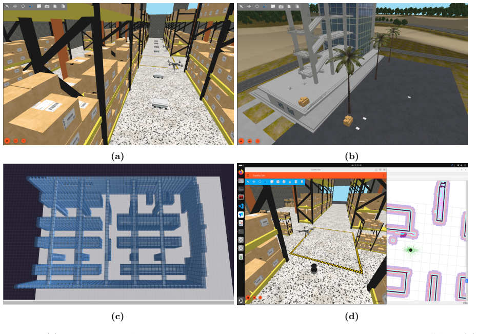
The central object is the 3D occupancy grid generated from a point cloud of a Gazebo world. Cells span 1 meter and are marked occupied if they contain point-cloud particles; this single grid becomes the shared representation for both aerial and ground pathfinding. Around this grid, SkyRover provides a Unified Algorithm Wrapper that standardizes init/step/reset interfaces so search-based and learning-based planners can be plugged in, and a Plan Executor that converts discrete grid paths into low-level control commands for PX4 flight controllers and Navigation2 ground controllers.
What would settle it
Take a Gazebo world containing an obstacle thinner than 1 meter, generate the occupancy grid with SkyRover, and run a 3D-A* path through the area. If the planned path cuts through the obstacle's true location, or if high-fidelity execution with a drone collides in simulation, then the grid generation fails to preserve obstacles that matter for real navigation.
Extended reading notes
Core claim
The paper's central claim is that SkyRover is the first environment to natively support collaborative UAV-AGV multi-agent pathfinding within one modular framework. It spans the full pipeline: a high-fidelity Gazebo world is converted via a point cloud into a 3D occupancy grid, this grid serves as the common interface for search-based solvers (3D A*, 3D CBS) and a learning-based solver (3D DCC), and a plan executor translates high-level routes into commands for external flight and navigation controllers. The authors demonstrate the system in warehouse and park scenarios with an inventory-scanning task and an aerial cargo-transfer task, and report preliminary results where all three solvers achieve 100% success in moving 22 agents (6 drones, 16 AGVs) without collision; the trained 3D-DCC model computes paths in 0.6 seconds.
Load-bearing premise
The simulator's usefulness rests on the assumption that the 3D occupancy grid built from a single point cloud at 1-meter resolution faithfully represents navigable space for both drones and ground vehicles.
Editorial extensions
If this is right
- Researchers can benchmark search-based and learning-based MAPF algorithms under identical 3D conditions, making cross-domain comparisons meaningful.
- Learning-based planners such as DCC can be trained and evaluated on 3D grids without needing separate simulators for aerial and ground agents.
- The same environment supports abstract teleportation for fast algorithm evaluation and low-level control for hardware-in-the-loop studies, so results can be checked at both fidelity levels.
- New realistic worlds can be added by loading a Gazebo model and automatically generating its occupancy grid, allowing scenario-specific testing.
Reading between the lines
- Because the 3D occupancy grid is resolution-limited to 1 meter, adding adaptive or multi-resolution grids would be a natural extension; the modular interface could accommodate such a change without breaking the rest of the pipeline.
- The shared grid representation could support training a single reinforcement-learning policy that controls both drones and ground vehicles, a capability the paper does not explicitly demonstrate but that the interface allows.
- SkyRover's dual execution modes, abstract and low-level, could enable studying the simulation-to-real gap by comparing grid-based plans against physics-based execution in the same world.
- The 'first' claim might be tested by checking the cited single-domain baselines for whether any already allowed mixed aerial-ground teams; the paper does not report such a check.
Editorial analysis
A structured set of objections, weighed in public.
Referee Report
Summary. SkyRover is a modular simulator for cross-domain multi-agent pathfinding (MAPF) involving UAVs and AGVs. The paper describes five integrated modules: a Gazebo-based world zoo, a 3D grid generator that converts a point cloud into a 1 m occupancy grid, a unified algorithm wrapper providing 3D A*, 3D CBS, and 3D DCC, a plan executor that interfaces with PX4 and Navigation2, and a system interface for ROS2 topics and RViz. Experiments in warehouse and park worlds demonstrate inventory scanning and aerial cargo transfer tasks, and preliminary results report computation time and success rates for the three algorithms. The paper claims that SkyRover is the first environment providing a unified toolkit for UAV-AGV MAPF research and the first to natively support collaborative UAV-AGV MAPF under a single modular framework.
Significance. If the claims are substantiated, SkyRover would be a useful contribution to the MAPF community by bridging high-fidelity robot simulation with discrete 3D pathfinding abstractions. The modular design, the choice of widely used external tools (Gazebo, ROS2, PX4, Navigation2), and the inclusion of both search-based and learning-based algorithms are clear strengths. The paper also provides a project website, which supports community uptake. However, the evidence presented is largely qualitative or based on single-run demonstrations; the central 'high-fidelity' and 'unified toolkit' claims require stronger quantitative validation before the contribution can be fully assessed.
major comments (3)
- [Section 4.1] The 3D occupancy grid is the only bridge between the Gazebo worlds and all MAPF algorithms, yet its fidelity is not validated. The paper states that a single point cloud is converted into a 0-1 grid with 1 m cells and that cells containing any point are labeled obstacles, but no ground-truth comparison, resolution sensitivity analysis, or handling of point-cloud gaps is reported. Because gaps are implicitly treated as free space, thin obstacles such as shelf legs or drone propellers may disappear, and a single 1 m resolution may merge narrow ground corridors or misrepresent overhang clearances that are critical for aerial vehicles. Since every algorithm plans on this grid, errors in this step propagate directly into the pathfinding results, so the high-fidelity claim is unsupported without additional validation.
- [Section 4.2 and Table 1] There is an internal inconsistency between the DCC evaluation and the reported table. The text says the well-trained 3D DCC model 'reaches 100% success under test conditions with sixteen agents,' while Table 1 reports results for 22 total agents (6 drones and 16 AGVs). The authors must clarify whether the 3D-DCC row in Table 1 was evaluated with 16 or 22 agents. In addition, Table 1 reports single-run computation times and 100% success rates without variance or repeated trials, so the comparison between 3D-A*, 3D-CBS, and 3D-DCC cannot be statistically assessed; at minimum, multiple seeds and runs with standard deviations should be reported.
- [Section 4.3] The claim that SkyRover supports 'high-fidelity' low-level motion control is not quantitatively demonstrated. Section 4.3 shows a single illustrative figure (Figure 2d) of a PX4-controlled drone and a Navigation2-controlled TurtleBot, but it provides no tracking-error measurements, trajectory comparisons between the planned grid path and the executed continuous path, or tests of collision avoidance under the low-level controllers. Without such data, the statement that these setups 'accurately capture kinematic and dynamic constraints' is an unsupported qualitative assertion.
minor comments (5)
- [Abstract and throughout] The text contains numerous spacing artifacts such as 'UA V' instead of 'UAV' and 'R Viz' instead of 'RViz'; a thorough proofread is needed.
- [References] The reference [Wan+24] appears twice with different author lists and venues; the two entries should be distinguished (e.g., [Wan+24a] and [Wan+24b]).
- [Section 4.2] The description of the 3D DCC training is very brief: no details are given for the curriculum, the network architecture, the training/test data distribution, or hyperparameters, which prevents reproduction and makes the 100% success claim hard to evaluate.
- [Sections 1 and 2] The novelty claims 'first environment' should be accompanied by a systematic comparison with existing 3D MAPF simulators and benchmarks (e.g., the MAPF in 3D Warehouses dataset by Wang et al., which is cited but not discussed in relation to SkyRover).
- [Section 4.4] The experimental setup reports the hardware and software versions but does not report the number of runs, random seeds, or the method for assigning start and goal locations, all of which are needed for reproducibility.
Circularity Check
No significant circularity: SkyRover is an integration-and-demonstration paper whose claims rest on external frameworks and algorithms, not on a derivation that reduces to its own inputs.
full rationale
The paper makes no formal derivation whose conclusion is equivalent to its premises. Its central claims are (i) architectural: SkyRover provides a modular pipeline from Gazebo worlds to 3D occupancy grids to MAPF algorithms to low-level controllers, and (ii) empirical: the included experiments show that 3D A*, 3D CBS, and a 3D adaptation of DCC run inside the simulator. The occupancy grid is generated by an external plugin (cited as [Ars22]) from a point cloud, and the pathfinding algorithms are standard external methods (A*, CBS, DCC). The DCC source [Ma21] is by different authors, so there is no load-bearing self-citation. The 'first environment' statements are novelty assertions, not derivations, and cannot be circular in the sense of this review. The fidelity of the 1-meter occupancy grid is an unvalidated modeling assumption and a legitimate correctness concern, but it is not a circular step: the paper does not define the simulator's success in terms of that grid, and the empirical results are reported as demonstrations rather than as predictions forced by construction. The possible inconsistency between DCC training with 16 agents (Section 4.2) and the 22-agent evaluation in Table 1 is a reporting issue, not a circularity. Therefore the appropriate finding is no significant circularity.
Assumptions & free parameters
assumptions (3)
- domain assumption The 3D occupancy grid, built from a single point cloud with 1-meter cells, faithfully represents obstacle and free space for both UAVs and AGVs.
- domain assumption The DCC model trained on random 40x40x40 grids with 16 agents generalizes to the warehouse world with 22 agents.
- domain assumption Teleporting agents via the Gazebo model-position service preserves the validity of pathfinding benchmarks.
Cite this review
Pith. "Pith review of SkyRover: A Modular Simulator for Cross-Domain Pathfinding." pith.science (2026). https://pith.science/paper/V45YZWJE
@misc{pith2026250208969,
  author       = {Pith},
  title        = {Pith review of: SkyRover: A Modular Simulator for Cross-Domain Pathfinding},
  year         = {2026},
  howpublished = {\url{https://pith.science/paper/V45YZWJE}},
  note         = {Machine review of arXiv:2502.08969}
}
read the original abstract
Unmanned Aerial Vehicles (UAVs) and Automated Guided Vehicles (AGVs) increasingly collaborate in logistics, surveillance, inspection tasks and etc. However, existing simulators often focus on a single domain, limiting cross-domain study. This paper presents the SkyRover, a modular simulator for UAV-AGV multi-agent pathfinding (MAPF). SkyRover supports realistic agent dynamics, configurable 3D environments, and convenient APIs for external solvers and learning methods. By unifying ground and aerial operations, it facilitates cross-domain algorithm design, testing, and benchmarking. Experiments highlight SkyRover's capacity for efficient pathfinding and high-fidelity simulations in UAV-AGV coordination. Project is available at https://sites.google.com/view/mapf3d/home.
Figures

Reference graph
Works this paper leans on
-
[1]
write newline
" write newline "" before.all 'output.state := FUNCTION fin.entry add.period write newline FUNCTION new.block output.state before.all = 'skip after.block 'output.state := if FUNCTION new.sentence output.state after.block = 'skip output.state before.all = 'skip after.sentence 'output.state := if if FUNCTION not #0 #1 if FUNCTION and 'skip pop #0 if FUNCTIO...
-
[2]
Wurman, Raffaello D'Andrea, and Mick Mountz
Peter R. Wurman, Raffaello D'Andrea, and Mick Mountz. Coordinating hundreds of cooperative, autonomous vehicles in warehouses. AI Magazine , 29(1):9, 2008
work page 2008
-
[3]
JD.com: Operations research algorithms drive intelligent warehouse robots to work
Hengle Qin, Jun Xiao, Dongdong Ge, Linwei Xin, Jianjun Gao, Simai He, Haodong Hu, and John Gunnar Carlsson. JD.com: Operations research algorithms drive intelligent warehouse robots to work. INFORMS Journal on Applied Analytics , 52(1):42--55, 2022
work page 2022
-
[4]
Learning to cooperate: Application of deep reinforcement learning for online AGV path finding
Yi Zhang, Yu Qian, Yichen Yao, Haoyuan Hu, and Yinghui Xu. Learning to cooperate: Application of deep reinforcement learning for online AGV path finding. In AAMAS , 2020
work page 2020
-
[5]
Scalability in perception for autonomous driving: Waymo open dataset
Pei Sun, Henrik Kretzschmar, Xerxes Dotiwalla, Aurelien Chouard, Vijaysai Patnaik, Paul Tsui, James Guo, Yin Zhou, Yuning Chai, Benjamin Caine, and others. Scalability in perception for autonomous driving: Waymo open dataset. In CVPR , 2020
work page 2020
-
[6]
Shiqi Wang, Zhouye Zhao, Yuhang Xie, Mingchuan Ma, Zirui Chen, Zeyu Wang, Bohao Su, Wenrui Xu, and Tianyi Li. Recent surge in public interest in transportation: Sentiment analysis of Baidu Apollo Go using Weibo data. arXiv:2408.10088 , 2024
work page Pith review arXiv 2024
-
[7]
Messier, and Sebastian Magierowski
Kevin Dorling, Jordan Heinrichs, Geoffrey G. Messier, and Sebastian Magierowski. Vehicle routing problems for drone delivery. IEEE Transactions on Systems, Man, and Cybernetics: Systems , 47(1):70--85, 2016
work page 2016
-
[8]
Valeska Engesser, Evy Rombaut, Lieselot Vanhaverbeke, and Philippe Lebeau. Autonomous delivery solutions for last-mile logistics operations: A literature review and research agenda. Sustainability , 15(3):2774, 2023
work page 2023
Show all 34 references
-
[9]
UAV-rider coordinated dispatching for the on-demand delivery service provider
Xuting Sun, Minghao Fang, Shu Guo, and Yue Hu. UAV-rider coordinated dispatching for the on-demand delivery service provider. Transportation Research Part E: Logistics and Transportation Review , 186:103571, 2024
2024
-
[10]
Isuru Munasinghe, Asanka Perera, and Ravinesh C. Deo. A comprehensive review of UAV-UGV collaboration: Advancements and challenges. Journal of Sensor and Actuator Networks , 13(6):81, 2024
2024
-
[11]
Cooperative path planning of UAVs & UGVs for a persistent surveillance task in urban environments
Yu Wu, Shaobo Wu, and Xinting Hu. Cooperative path planning of UAVs & UGVs for a persistent surveillance task in urban environments. IEEE Internet of Things Journal , 8(6):4906--4919, 2020
2020
-
[12]
Commanding cooperative UGV-UAV with nested vehicle routing for emergency resource delivery
Wei Gao, Junren Luo, Wanpeng Zhang, Weilin Yuan, and Zhiyong Liao. Commanding cooperative UGV-UAV with nested vehicle routing for emergency resource delivery. IEEE Access , 8:215691--215704, 2020
2020
-
[13]
Air-Ground Collaborative Robots for Fire and Rescue Missions: Towards Mapping and Navigation Perspective
Ying Zhang, Haibao Yan, Danni Zhu, Jiankun Wang, Cui-Hua Zhang, Weili Ding, Xi Luo, Changchun Hua, and Max Q-H Meng. Air-Ground Collaborative Robots for Fire and Rescue Missions: Towards Mapping and Navigation Perspective. arXiv:2412.20699 , 2024
2024 arXiv
-
[14]
Sensor planning for a symbiotic UAV and UGV system for precision agriculture
Pratap Tokekar, Joshua Vander Hook, David Mulla, and Volkan Isler. Sensor planning for a symbiotic UAV and UGV system for precision agriculture. IEEE Transactions on Robotics , 32(6):1498--1511, 2016
2016
-
[15]
Multi-agent pathfinding: Definitions, variants, and benchmarks
Roni Stern, Nathan Sturtevant, Ariel Felner, Sven Koenig, Hang Ma, Thayne Walker, Jiaoyang Li, Dor Atzmon, Liron Cohen, TK Kumar, and others. Multi-agent pathfinding: Definitions, variants, and benchmarks. In SoCS , 2019
2019
-
[16]
Problem Compilation for Multi-Agent Path Finding: a Survey
Pavel Surynek. Problem Compilation for Multi-Agent Path Finding: a Survey. In IJCAI , 2022
2022
-
[17]
Research challenges and opportunities in multi-agent path finding and multi-agent pickup and delivery problems
Oren Salzman and Roni Stern. Research challenges and opportunities in multi-agent path finding and multi-agent pickup and delivery problems. In AAMAS , 2020
2020
-
[18]
Graph-based multi-robot path finding and planning
Hang Ma. Graph-based multi-robot path finding and planning. Current Robotics Reports , 3(3):77--84, 2022
2022
-
[19]
A Comprehensive Review on Leveraging Machine Learning for Multi-Agent Path Finding
Jean-Marc Alkazzi and Keisuke Okumura. A Comprehensive Review on Leveraging Machine Learning for Multi-Agent Path Finding. IEEE Access , 12:57390--57409, 2024
2024
-
[20]
Iterative refinement for real-time multi-robot path planning
Keisuke Okumura, Yasumasa Tamura, and Xavier D \'e fago. Iterative refinement for real-time multi-robot path planning. In IROS , 2021
2021
-
[21]
Generalized target assignment and path finding using answer set programming
Van Nguyen, Philipp Obermeier, Tran Son, Torsten Schaub, and William Yeoh. Generalized target assignment and path finding using answer set programming. In SoCS , 2019
2019
-
[22]
POGEMA: A benchmark platform for cooperative multi-agent navigation
Alexey Skrynnik, Anton Andreychuk, Anatolii Borzilov, Alexander Chernyavskiy, Konstantin Yakovlev, and Aleksandr Panov. POGEMA: A benchmark platform for cooperative multi-agent navigation. arXiv:2407.14931 , 2024
2024 arXiv
-
[23]
MAPF in 3D Warehouses: Dataset and Analysis
Qian Wang, Rishi Veerapaneni, Yu Wu, Jiaoyang Li, and Maxim Likhachev. MAPF in 3D Warehouses: Dataset and Analysis. In ICAPS , 2024
2024
-
[24]
Mavswarm: A Lightweight Multi-Aerial Vehicle Simulator
Malintha Fernando. Mavswarm: A Lightweight Multi-Aerial Vehicle Simulator. GitHub , 2022. https://github.com/malintha/multi_uav_simulator
2022
-
[25]
R OS 2 G azebo World 2D/3D Map Generator
Arshad Mehmood. R OS 2 G azebo World 2D/3D Map Generator. GitHub , 2022. https://github.com/arshadlab/gazebo_map_creator
2022
-
[26]
Navigation2 Documentation
Navigation2 Contributors. Navigation2 Documentation. GitHub , 2025. https://github.com/ros-navigation/docs.nav2.org. https://docs.nav2.org
2025
-
[27]
e P rosima M icro XRCE - DDS : A DDS - XRCE Protocol Implementation for Resource Constrained Environments
eProsima. e P rosima M icro XRCE - DDS : A DDS - XRCE Protocol Implementation for Resource Constrained Environments. GitHub repository , 2024. https://github.com/eProsima/Micro-XRCE-DDS, version 3.0.0
2024
-
[28]
Hart, Nils J
Peter E. Hart, Nils J. Nilsson, and Bertram Raphael. A formal basis for the heuristic determination of minimum cost paths. IEEE Transactions on Systems Science and Cybernetics , 4(2):100--107, 1968
1968
-
[29]
Sturtevant
Guni Sharon, Roni Stern, Ariel Felner, Nathan R. Sturtevant. Conflict-based search for optimal multi-agent pathfinding. Artificial Intelligence , 219:40--66, 2015
2015
-
[30]
Learning selective communication for multi-agent path finding
Ziyuan Ma, Yudong Luo, and Jia Pan. Learning selective communication for multi-agent path finding. IEEE Robotics and Automation Letters , 7(2):1455--1462, 2021
2021
-
[31]
Design and use paradigms for gazebo, an open-source multi-robot simulator
Nathan Koenig and Andrew Howard. Design and use paradigms for gazebo, an open-source multi-robot simulator. In IROS , 2004
2004
-
[32]
Rviz: a toolkit for real domain data visualization
Hyeong Ryeol Kam, Sung-Ho Lee, Taejung Park, and Chang-Hun Kim. Rviz: a toolkit for real domain data visualization. Telecommunication Systems , 60:337--345, 2015
2015
-
[33]
PX4: A node-based multithreaded open source robotics framework for deeply embedded platforms
Lorenz Meier, Dominik Honegger, and Marc Pollefeys. PX4: A node-based multithreaded open source robotics framework for deeply embedded platforms. In ICRA , 2015
2015
-
[34]
Robot operating system 2: Design, architecture, and uses in the wild
Steven Macenski, Tully Foote, Brian Gerkey, Chris Lalancette, and William Woodall. Robot operating system 2: Design, architecture, and uses in the wild. Science robotics , 7(66):eabm6074, 2022
2022
Reviewed August 7, 2026 · model on record in the stance chip above.
Discussion (0). Continue with ORCID to comment.