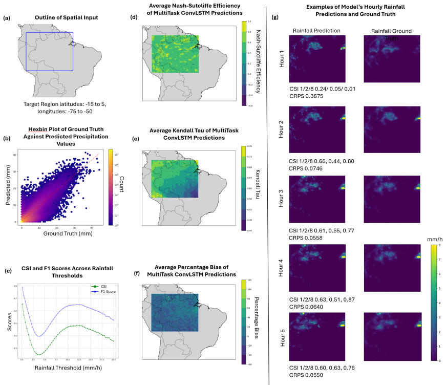
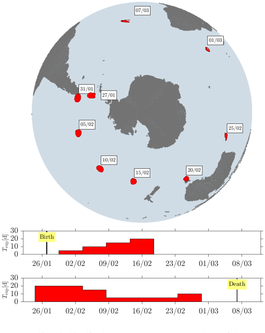
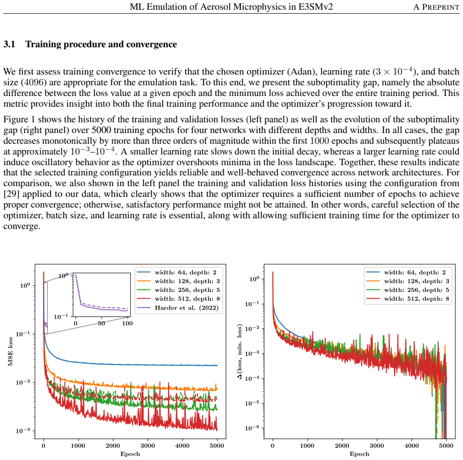
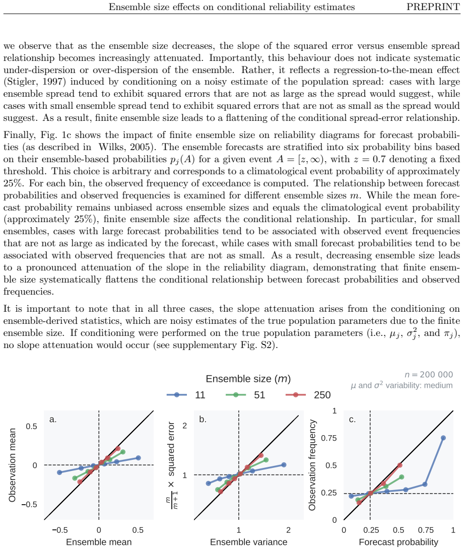
pith. machine review for the scientific record. sign in

physics.ao-ph

Atmospheric and Oceanic Physics

Atmospheric and oceanic physics and physical chemistry, biogeophysics, and climate science

0
physics.ao-ph 2026-05-13 2 theorems

Doubling CO2 lowers seawater pH by only 0.25 units

Acidification of Water by CO2

Buffering from alkalinity keeps the shift comparable to daily biological cycles and smaller than existing ocean variations.

Figure from the paper full image
abstract click to expand
Fundamental inorganic chemistry shows that increasing concentrations of atmospheric CO2 will have no harmful effect on organisms that live in the natural waters of the Earths, and may well benefit them. Alkalinity and dissolved CO2 give high buffering capacity to most natural waters and minimize the change of pH from external influences. For example, doubling the atmospheric concentration of CO2 from 430 ppm to 860 ppm would reduce the pH of representative sea water at a temperature of 25 C from pH = 8.18 to pH = 7.93. This change is comparable to diurnal pH changes in biologically productive surface waters, due to photosynthetic fixation of dissolved inorganic carbon during the day and respiration at night. The change is also less than the variations of pH with latitude, longitude and depth in the oceans. This paper includes a quantitative review of the carbonate chemistry of seawater and freshwater, the buffering capacity, the Revelle factor, the transport of calcium carbonate in ground water, the formation of flowstone, and the classic use of limewater to detect gaseous CO2. The paper concludes with a brief review of those parts of chemical thermodynamics that are involved in ocean acidification.
0
0
physics.ao-ph 2026-05-13 2 theorems

ML cloud subcolumn generator reduces radiation bias by factor of three

Assessment of cloud and associated radiation fields from a GAN stochastic cloud subcolumn generator

GAN approach better captures complex cloud layer interactions than analytical methods, improving accuracy of top-of-atmosphere radiation.

Figure from the paper full image
abstract click to expand
Modern Earth System Models (ESMs) operate on horizontal scales far larger than typical cloud features, requiring stochastic subcolumn generators to represent subgrid horizontal and vertical cloud variability. Traditional physically-based generators often rely on analytical cloud overlap paradigms, such as exponential-random decorrelation, which can struggle to capture the complex, anti-correlated behavior of non-contiguous cloud layers. In this study, we introduce a novel two-stage machine learning subcolumn generator for the GEOS atmospheric model, utilizing a Conditional Variational Autoencoder combined with a Generative Adversarial Network (CVAE-GAN) and a U-Net architecture. Trained on a merged CloudSat-CALIPSO height-resolved cloud optical depth dataset, the ML generator creates 56 stochastic subcolumns representing cloud occurrence and optical depth profiles. Evaluated against the established R\"{a}is\"{a}nen, the ML approach accurately reproduces bimodal cloud overlap distributions, significantly reduces biases in grid-mean statistics, and halves the root-mean-square error in ISCCP-style cloud-top pressure and optical thickness joint histograms. The improvements brought by our deep generative models translate into more accurate offline radiative transfer calculations, reducing the global-mean shortwave top-of-atmosphere cloud radiative effect bias by a factor of three. Provided that the generator can be accelerated on CPUs, this offers a practical pathway to reduce structural errors at the cloud-radiation interface.
0
0
physics.ao-ph 2026-05-13 Recognition

MLP scales small-ensemble covariances to cut EnKF error

Machine Learning-Based Covariance Correction for Ensemble Kalman Filter with Limited Ensemble Size

The network learns the gap to large-ensemble truth and applies an element-wise fix, raising accuracy at fixed cost.

Figure from the paper full image
abstract click to expand
Data assimilation (DA) integrates numerical model forecasts with observations to achieve the optimal state estimation. Ensemble-based methods, such as the ensemble Kalman filter (EnKF), are widely used for state estimation for high-dimensional and nonlinear dynamic systems. However, their performance strongly depends on the ensemble size, therefore causing a tradeoff problem between analysis accuracy and computational cost. To address this problem, this study presents a machine learning-based EnKF framework that maintains high accuracy with a relatively small ensemble size. Specifically, a multilayer perceptron (MLP) function is built to predict the difference between the forecast error covariances estimated from a limited ensemble and a sufficiently large ensemble, with the latter being assumed to be an accurate approximation of the underlying truth. This predicted covariance difference term is then incorporated into the EnKF algorithm via an element-wise scaling strategy, resulting in an amended forecast covariance matrix that better approximates the true uncertainty level and sequentially produces more accurate analysis results. To demonstrate the feasibility and robustness of the proposed algorithm, we perform a set of numerical experiments with the Lorenz-63 and Lorenz-96 systems under various configurations, and the results consistently indicate that the proposed algorithm can significantly outperform the standard EnKF with the same limited ensemble size, by achieving notably higher analysis accuracy while remaining computationally efficient. This approach provides a practical and feasible pathway to accurate and computationally efficient data assimilation for high-dimensional and nonlinear dynamic systems.
0
0
physics.ao-ph 2026-05-13 Recognition

Generative model preserves climate variable links at 50x resolution

Generative climate downscaling enables high-resolution compound risk assessment by preserving multivariate dependencies

This restores joint dependencies needed to assess compound hazards like drought and heat stress from coarse global projections.

Figure from the paper full image
abstract click to expand
Physics-based climate projections using general circulation models are essential for assessing future risks, but their coarse resolution limits regional decision-making. Statistical downscaling can efficiently add detail, yet many methods treat variables independently, degrading inter-variable relationships that govern compound hazards such as heat stress, drought, and wildfire. Here we show that a diffusion-based multivariate generative framework, combined with bias correction, recovers degraded inter-variable correlations even under a 50$\times$ increase in linear resolution. When applied to five meteorological variables over Japan, the framework reduces inter-variable correlation errors by more than fourfold relative to existing baselines while improving both univariate and spatial accuracy, leading to more accurate detection of severe drought. These results demonstrate that multivariate generative downscaling improves the reliability of compound risk assessment under large resolution gaps.
0
0
physics.ao-ph 2026-05-11 Recognition

CNN improves IR precipitation estimates for satellite merges

GPROF-IR: An Improved Single-Channel Infrared Precipitation Retrieval for Merged Satellite Precipitation Products

GPROF-IR uses temporal IR data to achieve lower errors than prior methods and consistency with microwave retrievals over land.

abstract click to expand
Current merged precipitation products such as IMERG, GSMAP, and CMORPH combine satellite estimates from passive microwave (PMW) and infrared (IR) observations. However, the different information content of these sensors makes it challenging to produce consistent precipitation estimates, even for coincident observations. The resulting inconsistencies between PMW and IR retrievals can introduce artifacts in the temporal evolution of merged precipitation fields and lead to an overreliance on time-propagated PMW estimates. We introduce GPROF-IR, a novel IR precipitation retrieval that leverages a convolutional neural network to improve precipitation estimates from single-channel IR observations. We demonstrate that the proposed model is able to leverage the temporal information in half-hourly IR observations to improve precipitation estimates. GPROF-IR is designed for integration into the upcoming release of the Integrated Multi-Satellite Retrieval for GPM (IMERG V08) and produces estimates that are climatologically consistent with the GPROF-NN PMW retrieval. We evaluate GPROF-IR using independent, global reference measurements and demonstrate substantial improvements over conventional IR retrievals. GPROF-IR provides lower mean squared error and higher correlation coefficient than IMERG V07 PMW estimates over continental land masses but remains below the accuracy of PMW precipitation estimates over sea surfaces and climate regimes with a greater influence from shallow precipitation. By expoiting both spatial and temporal information content in geostationary IR observations, GPROF-IR establishes a new state of the art for single-channel IR precipitation retrievals. GPROF-IR can be used to quasi-global precipitation estimates at half-hourly resolution from 1998 onward, providing a consistent and accurate foundation for improving merged precipitation products.
0
0
physics.ao-ph 2026-05-08 1 theorem

AI models match conventional climate models on historical data

AIMIP Phase 1: systematic evaluations of AI weather and climate models

Tests on biases, El Niño responses, and variability show comparable skill, but some underestimate warming trends and diverge out of sample.

Figure from the paper full image
abstract click to expand
We present the AI weather and climate model intercomparison project (AIMIP), phase 1. Drawing from the rich tradition of intercomparisons in climate model development, we specify a common experiment, output data format, and training constraints (namely, training against historical reanalysis data) for AIMIP Phase 1 models. We aim to identify differences in modeling frameworks and AI architectural choices that influence model behavior, and build trust in AI weather and climate models through open data and evaluation. AIMIP Phase 1 models must simulate the atmosphere given specified historical sea surface temperatures over 1979-2024. We evaluate the models' performance using five major evaluation criteria: biases, trends, response to El Ni\~{n}o-related sea surface temperature anomalies, temporal variability, and out-of-sample generalization tests. We find that the AI models are able to simulate the historical climate and response to forcing as well as a conventional physically-based model, but some AI models underestimate historical warming trends, and their predictions diverge in the out-of-sample generalization tests. We describe the AIMIP Phase 1 dataset that is publicly available for additional evaluations.
0
0
physics.ao-ph 2026-05-08 2 theorems

Localized perturbations decay before growing in SQG turbulence

Growth of small localized perturbations in Surface Quasi-Geostrophic turbulence

In a model of mesoscale geophysical flows the energy of small disturbances can fall for several small-scale times, with the length set by où

Figure from the paper full image
abstract click to expand
The ``butterfly effect'', i.e. the growth of a localized infinitesimal perturbation, is the fundamental property of chaotic systems. While the butterfly effect is today an obvious property of low-dimensional chaotic systems, its significance is more nuanced in extended systems with many spatial and temporal scales, such as geophysical flows. In this Letter we explore the butterfly effect, i.e., the fate of infinitesimal localized perturbations, in the Surface-Quasi-Geostrophic turbulence, a minimal model for mesoscale geophysical turbulence in the regime of strong stratification and rotation. We find that the evolution of a spatially localized perturbation exhibits strong variability, with an initial transient regime in which the perturbation energy decreases. The duration of this transient is broad and can persist for several small-scale characteristic times, depending on the initial location of the perturbation.
0
0
physics.ao-ph 2026-05-07

Neural networks predict orographic gravity wave fluxes with R² up to 0.72

Interpretable Neural Networks to Predict Momentum Fluxes of Orographic Gravity Waves

Trained on coarse-grained ERA5 data, the models recover physically consistent relationships and provide a route to improved gravity-wavedrag

Figure from the paper full image
abstract click to expand
State-of-the-art Earth system models (ESMs) cannot explicitly resolve many small-scale atmospheric processes such as atmospheric gravity waves, and thus must represent, or parameterise, their effects on the resolved state. Machine learning (ML) has the potential to improve these parameterisations. In our study, we train neural networks (NNs) on ERA5 reanalysis data to predict momentum fluxes of orographic gravity waves as a function of the state variables at the resolution of a coarse ESM. Employing a full year of data, we extract inertia-gravity waves using the software MODES, which applies linear theory for wave filtering, and train ML models on data coarse-grained to the ESM's target resolution. We consider four different cases: the full spectrum of inertia-gravity waves resolved in ERA5, or just the part of the spectrum that is subgrid-scale in the target ESM, both over all land or just over mountainous terrain. Our NNs successfully predict momentum fluxes, with a global coefficient of determination ($R^2$) ranging from 0.72 to 0.56, depending on the case, when evaluated offline with data from another year. An analysis of our models using SHAP values, an explainable AI technique, suggests that the networks learned physically meaningful relationships. In addition, we give a comparison with the physics-based parameterisation scheme by Lott and Miller. This work forms the basis for the development of operational ML-based parameterisations to improve the representation of gravity waves and their effects in climate models.
0
0
physics.ao-ph 2026-05-07 Recognition

Rain on Rosh Chodesh lifts rainy month odds by 16 points

Two Hebrew folk meteorological proverbs tested: rainfall on Rosh Chodesh and Shabbat Mevarechim as predictors of monthly precipitation (Israel, 1950-2024)

Israeli records from 1950 to 2024 confirm folk proverbs track real weather patterns now fading with shorter storms.

abstract click to expand
Folk meteorological proverbs encode centuries of empirical observation by agricultural communities. Two Hebrew proverbs link lunar calendar anchor days to monthly winter rainfall: (i) "If Rosh Chodesh is rainy, the whole month is rainy" and (ii) "If it rains on Shabbat Mevarechim, the whole month is rainy." Shabbat Mevarechim is the last Saturday before each new Hebrew month, preceding Rosh Chodesh by one to seven days. The first proverb is widely known; the second circulates in Hasidic oral tradition with no identified written source. Both have never been formally tested. We analyse 75 years (1950-2024) of daily precipitation data from seven Israeli cities across three climatic regions, comprising 191,758 station-days and 2,422 Hebrew-month observations during the winter rainy season (Marcheshvan-Adar). A rainy Rosh Chodesh increases the probability of a rainy month from 22.2% to 38.6% (lift +16.4 percentage points; chi-square = 57.8, p = 2.9e-14; Bayes factor 1.81). A rainy Shabbat Mevarechim produces a similar effect (lift +16.5 percentage points, p = 8.0e-13), despite preceding Rosh Chodesh by up to seven days. The effect decays with lag and mirrors daily rainfall autocorrelation (r = 0.35-0.44 at lag 1; ~0 at lag 7), consistent with Mediterranean cyclone persistence. A bootstrap permutation test (p < 1e-4) and a 15-year rolling analysis show declining predictive power (-0.20 percentage points per year, p < 0.001), consistent with shortening precipitation events under warming climate conditions. Both proverbs encode real but probabilistic meteorological signals whose reliability is decreasing over time.
0
0
physics.ao-ph 2026-05-06

Aerosol memory produces non-ergodic patterns in stratocumulus clouds

Aerosol memory in stratocumulus clouds leads to noise-induced patterns and non-ergodic sampling

Comparable timescales for transitions and aerosol changes mean satellite observations miss process information in bistable decks.

Figure from the paper full image
abstract click to expand
Stratocumulus cloud decks exhibit bistability between patterns of high (closed cells) and low (open cells) cloud fraction. Localized transitions between these two states (pockets of open cells) have been observed but their underlying mechanism remains unclear. We model stratocumulus and their interaction with atmospheric aerosol as a data-driven and physics-informed stochastic dynamical system with time-dependent parameters. This allows us to show that pockets of open cells result from noise-induced transitions between the stratocumulus patterns. We find comparable timescales for these transitions, mesoscale self-organization into patterns and the evolution of large-scale parameters. This lack of timescale separation corresponds to an aerosol memory in cloud evolution and means that the sampling of stratocumulus states by polar-orbiting satellites lacks the encoding of process information that would be present for an asymptotic and ergodic sampling.
0
0
physics.ao-ph 2026-05-06

Diffusion models cut error in extreme event probability estimates

Towards accurate extreme event likelihoods from diffusion model climate emulators

Odds ratios from guided versus unguided densities enable importance sampling of tropical cyclones with lower variance than Monte Carlo.

Figure from the paper full image
abstract click to expand
ML climate model emulators are useful for scenario planning and adaptation, allowing for cost-efficient experimentation. Recently, the diffusion model Climate in a Bottle (cBottle) has been proposed for generation of atmospheric states compatible with boundary conditions of solar position and sea surface temperatures. Crucially, cBottle can be guided to generate extreme events such as Tropical Cyclones (TCs) over locations of interest. Diffusion models such as cBottle work by approximating the probability density of the training data. Here, we show use cases of the probability density estimates of atmospheric states obtained from this climate emulator. Most importantly, these estimates allow us to calculate likelihoods of extreme events under guidance. When guiding the model towards states including TCs, comparing the probability density under the guided and unguided model enables us to quantify how much more likely the guidance has made the TC. We show how these odds ratios allow us to importance-sample from the TC distribution, reducing the standard error of the probability estimate compared to simple Monte Carlo sampling. Furthermore, we discuss results and limitations of the application of model probability densities to extreme event attribution-like experiments. We present these early but encouraging results hoping they will spur more research into probabilistic information that can be gained from diffusion models of the atmosphere.
0
0
physics.ao-ph 2026-05-05 Recognition

KAN surrogate emulates atmospheric coefficients with top accuracy and four-order speedup

Multi-Fidelity Emulation of Atmospheric Correction Coefficients with Physics-Guided Kolmogorov-Arnold Networks

By learning residuals from paired 6S and libRadtran runs and adding a physics penalty, pKANrtm beats regression baselines on both routine,

Figure from the paper full image
abstract click to expand
Atmospheric correction is a critical preprocessing step in optical remote sensing, but repeated high-fidelity radiative transfer simulations remain computationally expensive for dense look-up-table generation, sensitivity analysis, retrieval support, and operational preprocessing. This study presents a physics-aware multi-fidelity surrogate framework for emulating atmospheric correction coefficients using paired 6S and libRadtran simulations. Atmospheric and geometric states are sampled using Latin Hypercube Sampling, and both radiative transfer models are evaluated under matched conditions for Sentinel-2 bands using spectral-response-function-aware coefficient generation. The high-fidelity targets are path reflectance, total transmittance, and spherical albedo. A physics-guided Kolmogorov-Arnold Network, termed pKANrtm, receives the atmospheric state and low-fidelity 6S coefficients, predicts the residual relative to libRadtran, and reconstructs the high-fidelity coefficients. The pKANrtm model uses an Efficient-KAN architecture and is trained with a physics-consistency penalty applied in the original coefficient space. The proposed model is evaluated against state-of-the-art regression-based RTM surrogates. Across both standard and out-of-distribution evaluation settings, pKANrtm achieves the strongest overall predictive performance among the compared models. Runtime benchmarking demonstrates substantial acceleration relative to libRadtran, with GPU inference providing approximately four orders of magnitude single-sample speedup and batched inference reaching tens of thousands of samples per second. These results indicate that physics-aware multi-fidelity pKANrtm emulation provides an accurate, physically structured, and computationally efficient strategy for atmospheric correction coefficient generation.
0
0
physics.ao-ph 2026-05-05

Dynamic traffic emissions sharpen urban NO2 hotspot forecasts

Hyperlocal urban NO2 hotspot modeling driven by microscopic traffic data

Coupled mesoscopic traffic and dispersion runs outperform static baselines at street-canyon sites and during concentration peaks.

abstract click to expand
Road-traffic NO2 hotspots are still often modelled with static emissions and generic temporal profiles, although near-road concentrations respond strongly to rapidly changing traffic conditions. Here, we test whether detector-informed dynamic traffic emissions improve hyperlocal NO2 modelling relative to a conventional static baseline. To this end, we couple an online-calibrated mesoscopic traffic model (SUMO) with the LES-based urban dispersion model CAIRDIO in a nested high-resolution framework for Leipzig, Germany. We compare two otherwise identical experiment setups: a static reference simulation and a coupled simulation in which road-traffic emissions within the SUMO domain are replaced by dynamic emissions derived from simulated traffic states. The framework is designed for city-wide high-resolution application, while the present evaluation focuses on two traffic-oriented hotspot settings during two one-week periods. Compared against hourly NO2 observations of official air quality monitoring, the coupled setup performs better overall, with the clearest improvement at the street-canyon hotspot and in the representation of concentration peaks. Dynamic traffic emissions therefore provide clear added value for hyperlocal NO2 prediction where hotspot realism and exposure-relevant peaks matter.
0
0
physics.ao-ph 2026-05-04 3 theorems

Cubed-sphere grids and nudging lift data-driven weather forecasts

Cast3: Translating numerical weather prediction principles into data-driven forecasting

Cast3 builds diverse ensembles on variable-resolution grids then collapses them into single forecasts that beat prior deterministic and AI-

abstract click to expand
Data-driven weather models have made rapid advances in recent years, reaching and in some metrics surpassing the large-scale forecast skill of operational numerical weather prediction. This progress, however, has been built almost entirely on the reanalysis data that NWP produced, while the methodological knowledge that the NWP community distilled over decades of multi-scale atmospheric modelling remains largely unused. Here we present Cast3, a generative forecasting framework that systematically absorbs NWP meta-knowledge to close this gap. Cast3 operates on variable-resolution cubed-sphere grids for scale-aware representation and constructs structurally diverse super-ensembles that sample the complementary biases of different grid discretizations, delivering state-of-the-art ensemble prediction. It further introduces generative nudging, a posterior-sampling strategy that distils the collective information of the full ensemble into a single forecast possessing both the large-scale accuracy of the ensemble mean and the mesoscale realism of a high-resolution member. Evaluated across synoptic-scale skill, spectral fidelity, station-level surface verification, and tropical cyclone prediction, Cast3 outperforms established deterministic and generative baselines across various dimensions. More broadly, these results demonstrate that the design principles embedded in computational atmospheric science offer a rich and largely untapped foundation for the next generation of data-driven Earth system modelling.
0
0
physics.ao-ph 2026-05-04

Tropical SST network predicts Tamil Nadu rain 10 months out

Prediction and Predictability of the Wet-Season Rainfall over Southeast India

Global sea surface temperature patterns across the tropics offer long-lead skill for southeast India's wet season despite rising variability

abstract click to expand
The challenge in predicting sub-regional climate within the Indian monsoon region is exacerbated by its increasing variability in a warming world. While exploring the seasonal predictability of rainfall over the state of Tamil Nadu in southeast India, we identify an overall increase in the monthly rainfall and its variability in recent years due to an increase in surface temperature, water vapour and moisture convergence. We attribute the increasing excess rainfall to a long-term reduction in convective inhibition. We further find an increasing trend in the length of the rainy season due to an earlier onset and a delayed withdrawal of the large-scale monsoon over the southeastern and southwestern regions of southern peninsular India, respectively. Further, the simultaneous (0- month lead) predictability of the primary wet-season (October-December, OND) rainfall over Tamil Nadu is dominated by sea surface temperature (SST) anomalies in the North Indian Ocean. However, a global tropical SST climate network reveals a high potential predictability and potential to realize significant forecast skill at a lead time of up to 10 months. The long-lead predictability arises from SST and rainfall interactions across the tropical Indo-Pacific and equatorial Atlantic regions. Our findings provide a robust data-driven methodology for skillful seasonal rainfall prediction over Tamil Nadu, despite the increasing rainfall variability.
0
0
physics.ao-ph 2026-05-04

Physical models enhance climate-resilient power system planning

Leveraging Climate Services to Build Climate Resilient Power Systems

The PECD4.2 database provides harmonized climate data and physical conversions for wind and solar that adapt to future conditions betterthan

abstract click to expand
We explore the crucial interplay between climate change and power system planning, highlighting the urgent need to systematically integrate climate information into energy system studies. Climate change impacts the energy sector on multiple fronts. Short-term weather variability drives daily and seasonal fluctuations in supply and demand. Long-term trends and increased frequency of extremes pose risks to infrastructure performance, asset lifetimes, and system adequacy. Representing compound events and spatial correlations across borders is a complex challenge, and uncertainties persist due to uncertainties from different models, scenarios, and downscaling methodologies. The Pan-European Climate Database (PECD4.2), developed in partnership between ENTSO-E and C3S, marks a change in how energy system planning is conducted. The PECD4.2 integrates historical reanalysis and six climate models across four SSP's, providing harmonised, openly available datasets tailored for power system studies. The physical conversion models for wind and solar energy better reflect technological progression than machine learning methods trained on historical data, improving robustness under changing future conditions. Despite these advances, challenges remain. Particularly in hydropower modelling and the lack of public harmonised energy datasets that are required to train these models. Complex processing chains from raw climate data to actionable insights and the lack of standardized integration of climate information lengthen lead times for energy-sector adoption. This leads to diverging approaches and variable consideration of climate risks. Closer, more generalised collaboration and communication between climate service providers and energy stakeholders are therefore necessary, as are the development of user-friendly tools for data manipulation and analysis and robust feedback loops.
0
0
physics.ao-ph 2026-05-04

Ocean coupling extends MJO forecast skill by five days

The role of the oceans for subseasonal prediction: insights from eddy-permitting and eddy-rich coupled forecast systems

Tropical subseasonal ensemble predictions gain accuracy with coupling as lead times lengthen, while extratropics and finer ocean grids show

Figure from the paper full image
abstract click to expand
The oceans play a fundamental role in Earth's climate system, redistributing heat and influencing global and regional climate variability and predictability across weather and climate timescales. The benefits of ocean-atmosphere coupling for initialised predictions depend on the balance between improvements associated with more realistic air-sea interactions and dynamics, and degradations arising from the development of systematic biases at the coupling interface. Here, we draw on recent developments in modelling and data assimilation at ECMWF to revisit the role of ocean-atmosphere coupling in subseasonal predictions. In particular, we evaluate the impact of ocean-atmosphere coupling in 46-day reforecasts produced with the ECMWF Integrated Forecasting System (IFS) and explore the potential for improvements through increased horizontal resolution and a better representation of the ocean mesoscale. We find that ocean-atmosphere coupling significantly enhances ensemble forecast skill in the tropics, with positive effects increasing at longer lead times. In particular, Madden-Julian Oscillation (MJO) forecasts are substantially improved, with forecast skill extended by approximately 5 days compared to the uncoupled configuration. In contrast, ocean-atmosphere coupling has a more limited impact on the extratropical atmosphere at subseasonal timescales, with marginal impacts on the predictability of major tropospheric and stratospheric circulation indices. Finally, we present selected results from an experimental eddy-rich coupled configuration of the IFS, with a horizontal ocean resolution of approximately 8 km. We find that a better-resolved representation of the ocean mesoscale has a limited impact on atmospheric forecasts at subseasonal lead times, which suggests that many of the known deficiencies of the eddy-permitting reference configuration are mitigated by accurate initialisation.
0
0
physics.ao-ph 2026-05-01 2 theorems

Neural network speeds atmospheric advection 92-fold

Acceleration of horizontal numerical advection for atmospheric modeling through surrogate modeling with temporal coarse-graining

Temporal coarse-graining lets the surrogate take larger steps than stability allows while preserving full spatial resolution

Figure from the paper full image
abstract click to expand
Machine-learned surrogate modeling of advection may accelerate geoscientific models, but existing approaches have either achieved limited speedup or have sacrificed spatial resolution compared to the model they are trained to emulate. We developed a machine-learned solver that speeds up advection simulations without sacrificing spatial resolution through the use of temporal coarse-graining, where the model is trained to take larger integration steps than dictated by the Courant-Friedrich-Lewy (CFL) condition. Our solver framework includes a convolutional neural network that takes concentrations and CFL numbers as inputs and outputs mass flux. Our solvers emulate 10-day ground-level horizontal advection simulations with r$^2$ values against the baseline ranging from 0.60--0.98 with temporal coarsening factors of 4 to 32 times the baseline integration time step. Speed increases and accuracy decreases with increased coarsening, with $r^2 = 0.24$ in accuracy lost for every factor of 10 gained in speed, reaching a maximum 92$\times$ speedup while maintaining $r^2 = 0.60$. We deliberately trained our solvers only on January ground-level wind data to examine their ability to generalize across seasons and vertical heights. The 4$\times$-coarsened learned solver successfully reproduces simulations over 72 vertical levels. The 8$\times$--16$\times$ solvers (but not 32$\times$) emulate most vertical levels. The learned solvers also generalize well across seasons, except for instabilities in June and October. With additional fine-tuning, these learned solvers could be appropriate for operational use where trading accuracy for speed could be advantageous, such as in screening tools, in ensemble simulations, or with data assimilation.
0
0
physics.ao-ph 2026-05-01

Clustering fits parabolic models to count tracks in ionograms

Physically-Informed Fuzzy Clustering of Vertical Sounding Ionograms

Expectation-maximization with six-parameter curves and modified BIC selects the optimal number for disturbed ionospheric data.

Figure from the paper full image
abstract click to expand
This paper presents a physically-informed fuzzy clustering of vertical sounding ionograms for automatically separating the ionogram into tracks suitable for further interpretation and determining their optimal number. The model is designed for use not only in conditions where the number of tracks is known, but also in disturbed ionospheric conditions where the number of tracks is preliminary unknown. The method is based on an expectation-maximization algorithm, used for clustering, and on parametrically specified distributions of distances from points to parametrically specified curves. The curves used as track models are close to model tracks in the parabolic ionospheric layer model. The resulting model of each track has six parameters: three standard ones (the critical frequency, the lower boundary of the layer, and its half-width), and three additional ones to take into account possible underlying layer effects. By sequentially increasing the number of tracks and optimizing their parameters, the model finds the optimal number of tracks on the ionogram by minimizing the modified Bayesian information criterion. The Sequential Least Squares Quadratic Programming algorithm is used to find the parameters of a single track. The width of each single track is assumed to be unknown constant found during fitting process. To improve the quality of ionogram clustering, automatic adaptive noise filtering is performed before clustering. This filtering is based on a combination of the DBSCAN and Gaussian Mixture algorithms. Also, to improve clustering quality on an ionosonde without hardware separation of the ordinary and extraordinary components, a preliminary approximate removal of points belonging to the extraordinary mode is performed.
0
0
physics.ao-ph 2026-05-01

Amazon rainforest may already exceed safe warming and deforestation limits

Quantifying the safe operating space for the Amazon rainforest under climate change and deforestation

At 1.4 °C warming and 17 % deforestation, over a third faces high tipping risk, supporting the need to meet Paris targets and end net forest

abstract click to expand
The Amazon rainforest is considered one of the core tipping elements in the climate system with a potential tipping point from rainforest to savannah between 2 and 6 {\deg}C of global warming. However, ongoing deforestation constitutes an additional major threat to the Amazon rainforest that acts simultaneously to undermine the stability of the rainforest. Both effects could synergistically compound and lower the overall threshold in global warming and deforestation when tipping points may be crossed. Here, we quantify the safe operating space of the Amazon rainforest, which we define as the joint global warming and deforestation conditions where resilience of the system as a whole is preserved. Based on the underlying environmental data from a global climate model, we use a reduced complexity model and explicitly take into account the adaptive capacities of the forest as well as the atmospheric moisture recycling. We quantify that under current conditions of around 1.4 {\deg}C of global warming and around 17 % of deforestation, more than a third of the Amazon rainforest is at high risk of crossing critical thresholds. We therefore conclude that the Amazon rainforest may have already left its safe operating space. Furthermore, we find that the historic and projected deforestation pattern could be particularly detrimental. Our results support the need for ambitious climate action to hold the Paris climate target and also nature protection to end net deforestation.
0
0
physics.ao-ph 2026-05-01 2 theorems

Ageostrophic shear boosts ocean overturning instability by 20%

Overturning instability in forced ageostrophic oceanic flows

New criteria show mechanical boundary forcing alters stability beyond geostrophic PV rules in subpolar fronts.

Figure from the paper full image
abstract click to expand
The subpolar oceans are characterized by intense storm forcing and complex littoral topography. Submesoscale frontal instabilities are significant sources of turbulent kinetic energy (TKE) in these regions. However, criteria for identifying and parameterizing these instabilities in regional models have predominantly relied on a geostrophic framework that neglects generalized ageostrophic shear. We derive criteria for overturning instability that account for stabilizing and destabilizing effects of ageostrophic shear on mechanically forced boundaries, deviating from the geostrophically derived potential vorticity (PV) criterion, $qf < 0$. Ageostrophic forcing modifies stability from that implied by the vertical PV structure underlying bulk surface boundary layer diagnostics, which may limit the applicability of such bulk criteria in strongly forced regimes and motivate the need for layer-resolved measures. We demonstrate their application using a feature model of a wind-forced jet, as well as a 1-km Regional Ocean Modeling System (ROMS) hindcast of the high North Atlantic, and assess the importance of forced ageostrophic overturning instability (AOI) in intense frontal zones. In the feature model, ageostrophic shear increases overturning instability by up to 20%, compared to a strictly geostrophic framework.
0
0
physics.ao-ph 2026-04-30 1 theorem

Multi-sensor system maps Pakistan floods daily in near real time

Continuous Flood Nowcasting in South Asia: A Multi-Sensor Ensemble Remote Sensing Framework for Flood Extent

Tiered fusion of Sentinel-1, Landsat, MODIS and VIIRS sensors keeps continuous inundation coverage through the 2025 monsoon

Figure from the paper full image
abstract click to expand
Pakistan experienced an unusually severe flood season between June and December 2025, with cascading impacts on population, infrastructure, and agriculture. Existing operational flood products (e.g., UNOSAT) provide valuable episode-level snapshots but rarely deliver spatially and temporally continuous inundation maps at near-real-time latency within the country. We present a multi-sensor, ensemble-based remote-sensing framework for continuous flood nowcasting in Pakistan that integrates Sentinel-1 SAR, Harmonized Landsat-Sentinel (HLS L30 and S30), MODIS, and VIIRS observations on a harmonized grid in Google Earth Engine. The framework employs a tiered nowcasting ensemble that prioritizes higher-resolution sensors (Sentinel-1 and HLS) and falls back to MODIS and VIIRS when necessary, preserving daily continuity of flood extent at each sensor's native resolution. Applied to the 2025 monsoon period, the system generates near-real-time, spatially consistent inundation maps across Pakistan. As a nowcasting case study, we track the super-flood of 26 August-7 September 2025 day by day, demonstrating the framework's ability to capture the evolving flood footprint in near real time and extend beyond the temporal limits of episodic mapping products. Validation against GloFAS discharge anomalies and precipitation datasets (CHIRPS v3.0, MSWEP) shows strong agreement with observed hydrometeorological conditions. By integrating nowcast outputs with exposure layers (WorldPop, ESA WorldCover, Giga-HOTOSM), the framework enables rapid estimation of affected populations, cropland, and critical infrastructure, supporting timely disaster response and resilience planning in South Asia.
0
0
physics.ao-ph 2026-04-30 Recognition

Regularized fit recovers KE spectra from drifter structure functions

Estimating the Kinetic Energy Spectrum from the Second-Order Velocity Structure Function using a Regularized Fitting Approach

By assuming a few power-law segments the method stably inverts the non-local structure-function relation for sparse ocean observations.

abstract click to expand
Ocean turbulence plays a key role in shaping large-scale circulation, heat uptake, and biogeochemical processes. The kinetic energy (KE) wavenumber spectrum is a fundamental diagnostic, quantifying how KE is distributed across spatial scales. The second-order structure function -- computed from velocity differences between spatially separated observations -- provides a complementary measure, but unlike the KE spectrum, it reflects a non-local, weighted integral of KE over all scales. Analytic relationships link the two metrics, permitting forward and inverse transformations between them. However, recovering the KE spectrum from the structure function via the inverse relationship is highly sensitive to sampling limitations and numerical discretization errors. Here we propose a regularized approach in which the spectrum is assumed to consist of a finite number of segments with distinct slopes and amplitudes, and the inversion is formulated as an optimization problem. The approach is first validated in an idealized setting; for a number of idealized KE spectra with prescribed sets of spectral slopes and amplitudes, the corresponding structure functions are computed by numerically evaluating the forward relationship. These structure functions are then used to determine the underlying parameters using our proposed approach, which shows that we are able to perfectly recover the parameters and consequently the KE spectra. The method is further evaluated on high-resolution ocean model output, where it reconstructs the underlying spectra well even in the presence of noise. Finally, we apply the method to surface drifter observations (GLAD and LASER experiments). The results show that the framework enables estimation of the KE spectrum from sparse Lagrangian data, extending spectral diagnostics beyond gridded Eulerian measurements.
0
0
physics.ao-ph 2026-04-30

Regularized fit recovers ocean KE spectra from structure functions

Estimating the Kinetic Energy Spectrum from the Second-Order Velocity Structure Function using a Regularized Fitting Approach

The method works on idealized tests, noisy models and sparse drifter data to estimate energy across scales.

abstract click to expand
Ocean turbulence plays a key role in shaping large-scale circulation, heat uptake, and biogeochemical processes. The kinetic energy (KE) wavenumber spectrum is a fundamental diagnostic, quantifying how KE is distributed across spatial scales. The second-order structure function -- computed from velocity differences between spatially separated observations -- provides a complementary measure, but unlike the KE spectrum, it reflects a non-local, weighted integral of KE over all scales. Analytic relationships link the two metrics, permitting forward and inverse transformations between them. However, recovering the KE spectrum from the structure function via the inverse relationship is highly sensitive to sampling limitations and numerical discretization errors. Here we propose a regularized approach in which the spectrum is assumed to consist of a finite number of segments with distinct slopes and amplitudes, and the inversion is formulated as an optimization problem. The approach is first validated in an idealized setting; for a number of idealized KE spectra with prescribed sets of spectral slopes and amplitudes, the corresponding structure functions are computed by numerically evaluating the forward relationship. These structure functions are then used to determine the underlying parameters using our proposed approach, which shows that we are able to perfectly recover the parameters and consequently the KE spectra. The method is further evaluated on high-resolution ocean model output, where it reconstructs the underlying spectra well even in the presence of noise. Finally, we apply the method to surface drifter observations (GLAD and LASER experiments). The results show that the framework enables estimation of the KE spectrum from sparse Lagrangian data, extending spectral diagnostics beyond gridded Eulerian measurements.
0
0
physics.ao-ph 2026-04-30

Explicit km-scale models yield fewer Atlantic hurricanes from weak seed vortices

Dynamics of East Atlantic seed vortex populations in global km-scale models

They fail to sustain top-heavy mass flux profiles that strengthen vortices crossing from West Africa, unlike coarser parameterized runs.

Figure from the paper full image
abstract click to expand
Africa is the primary source of cyclonic vortices over the tropical Atlantic. Over both land and sea, these vortices are entwined with deep convective activity, with the majority being African Easterly Wave troughs. Their convective interactions have downstream impacts, since the same vortices provide the seed population for Atlantic basin tropical cyclone (TC) genesis. Understanding the dynamics of East Atlantic seed populations, particularly the processes that distinguish vortices which undergo cyclogenesis, is crucial for understanding the formation of Atlantic hurricanes and model representations of their populations. Here we investigate these questions in three one-year, atmosphere-only global km-scale Met Office Unified Model simulations. We use objective tracking algorithms to independently identify seed vortices, easterly waves, TCs, and Mesoscale Convective Systems (MCSs), benchmarking against reanalysis and satellite-derived climatologies. Despite the simulations displaying comparable continental vortex populations, we show that the highest-resolution simulation with explicit convection produces fewer, weaker hurricanes than coarser, parameterised counterparts due to a failure to amplify vortices crossing the West African coastline. We identify a failure to maintain strong top-heavy mass flux profiles experienced by seeds as the primary cause, demonstrating profiles' roles in low-level circulation development through vortex stretching. Using MCS tracks, we show that systematic differences in convective organisation between the simulations can explain the differences in mass flux profiles, and thus vortex evolution. Deficiencies in the explicit simulation stem from underestimation of MCS stratiform components, a bias shared with other explicit convection models; and a latitudinal offset between offshore seed vortex and MCS trains.
0
0
physics.ao-ph 2026-04-30 2 theorems

Amazon deforestation cuts heavy rain by 7 percent

Interpretable rainfall modelling reveals rapid reorganisation of Amazonian rainfall under vegetation loss

Neural model detects asymmetric rainfall shifts and threshold drop after two to three months of sustained forest loss

Figure from the paper full image
abstract click to expand
Understanding how vegetation loss alters rainfall remains a major challenge in climate and hydrological science, as deforestation modifies precipitation through heterogeneous, seasonal and nonlinear land-atmosphere feedbacks. Existing models struggle to capture these dynamics: convection is parameterised at coarse scales, tipping behaviour is poorly constrained, and rainfall-deforestation analyses are limited to multi-decadal timescales. Therefore, many approaches resolve correlations rather than causal effects, limiting our ability to anticipate hydrological disruption. Using a neural-network model for hourly rainfall prediction, combined with pathway diagnostics and sensitivity analyses, we examine how vegetation perturbations reorganise rainfall across space, intensity regimes, and timescales under deforestation. We assess whether the model captures physically consistent dependencies linking vegetation, atmospheric state, and precipitation, and whether sustained canopy loss induces threshold behaviour. The model accurately predicts rainfall occurrence and intensity (Spearman = 0.84, F1 = 0.93, ROC-AUC = 0.98) and learns temporally ordered dependencies aligned with ecohydrological theory. Sensitivity analyses reveal rapid, asymmetric responses to vegetation loss: heavy rainfall (20-50 mm/h) declines by up to 7% under sustained deforestation, while light rainfall (0.1-1 mm/h) increases by 4%. Rainfall entropy rises by 1.3%, and dry-season intensity increases by 0.3-0.5% per 0.5% forest-cover loss, with strongest impacts in the north-western Amazon and Andean foothills. Threshold analysis reveals a sharp decline in precipitating area fraction after 2-3 months of sustained vegetation change in sensitive regions. These results demonstrate that data-driven approaches uncover process-relevant land-atmosphere coupling and highlight growing hydrological vulnerability in the Amazon.
0
0
physics.ao-ph 2026-04-30

DMD model forecasts Antarctic sea ice anomalies two years ahead

Multiscale Decomposition Reveals Predictable Interannual Variability and Climate Trends in Antarctic Sea Ice Loss

Stationary modes separate predictable interannual variability from a dominant climate trend that emerged in 2012.

Figure from the paper full image
abstract click to expand
Antarctic sea ice has undergone unprecedented changes in recent years, raising questions about how this key geophysical system is responding to climate change. Decades of slow expansion were replaced by a precipitous decline in 2014-2017, a subsequent apparent recovery, and a renewed collapse from 2022 to the present. We diagnosed sea ice concentration (SIC) from satellite observations with a hierarchical decomposition method based on Dynamic Mode Decomposition (DMD) that finds coherent spatiotemporal modes. We find that the 2014-2017 decline and apparent recovery are the result of interacting interannual modes and that a climate change signal emerges in 2012, which becomes unambiguous by 2022 when it dominates over interannual variability. These rapid changes underscore the need for seasonal-to-annual forecasts of SIC. However, existing forecasts are subject to limited prediction horizons combined with high computational costs. Our predictive DMD model (IceDMD) is regularised to prioritize the stationary spatiotemporal modes found by the decomposition. The predictive model can forecast SIC anomalies in 2023-2024 up to two years in advance, outperforming all existing approaches with the additional benefits of physical interpretability and extremely cheap computational cost. Finally, this framework for regularising predictive DMD models can be generalized to a range of multi-scale systems.
0
0
physics.ao-ph 2026-04-29

Neural emulator matches flood simulator using one gauge

Observation-Guided Neural Surrogate Learning for Scientific Simulation Emulation: A Single-Gauge Flood-Inundation Proof of Concept

U-Net corrector trained only at a single gauge pixel reproduces full LISFLOOD-FP maps with 0.99 R-squared on held-out events.

Figure from the paper full image
abstract click to expand
We present an observation-guided neural surrogate-learning framework for scientific simulation emulation, demonstrated on urban flood-inundation mapping. The framework combines LISFLOOD-FP hydrodynamic simulations with a real Gauge L stage record that is mapped to the simulation grid and converted to a datum-consistent local water-depth target before being used as single-site supervision. Focusing on a 256 x 256 crop around Gauge L in the Chicago metropolitan area, the method first constructs an ensemble-approximated Gaussian-process/local analogue surrogate (EnsCGP) to obtain a coarse flood-depth estimate and an uncertainty proxy. A U-Net-ASPP neural corrector then refines the coarse map using only simulation-derived and geospatial inputs: EnsCGP depth, the uncertainty proxy, rainfall, and spatial coordinates. The converted gauge-derived local depth is used only as a pointwise training target at the mapped gauge pixel; simulation-based losses are evaluated away from that pixel. Across temporally held-out events from 2013-2019, the emulator closely reproduces LISFLOOD-FP simulation targets outside the gauge-constrained pixel, with R^2 approximately 0.99 and mean absolute error below 0.01 m, and shows strong pointwise consistency with the converted Gauge L local depth target under the stated rolling-year protocol. We interpret these results as strong simulator-emulation agreement with pointwise observation-guided correction, not as independent validation of real-world inundation accuracy or as a complete operational flood-forecasting system.
0
0
physics.ao-ph 2026-04-29 Recognition

Neural nets detect 38% of summer Black Sea hypoxia from satellites

The Physical Limit of Neural Hypoxia Detection in the Black Sea from Satellite Observations

Surface data reach only the homogeneous mixed layer, leaving deeper oxygen loss hidden by stratification.

Figure from the paper full image
abstract click to expand
Coastal hypoxia (O_2 < 63 [mmol / m^3]) threatens ocean health worldwide. On continental shelves, summer stratification prevents bottom oxygen consumed by respiration from being renewed, making monitoring essential to protect vulnerable ecosystems and reduce biodiversity loss. Although satellite observations are increasingly available, their potential to infer subsurface oxygen remains largely unexplored. This can be framed as a Bayesian inverse problem relating surface observations to the complete Black Sea states. Here, we solve it using a deep generative neural network trained on numerical model outputs, providing a tractable and computationally efficient approximation of the true posterior distribution of sea states. We find that accurate state estimation is limited to the mixed layer, because its homogeneity makes surface conditions representative of subsurface states. During summer, we detect 38% of all hypoxic events shelf-wide with a precision of 47%. Improving results will likely require longer assimilation windows or sub-surface observations.
0
0
physics.ao-ph 2026-04-29

Neural net spots 38% of Black Sea summer hypoxia from satellites

The Physical Limit of Neural Hypoxia Detection in the Black Sea from Satellite Observations

The method works only in the mixing layer where surface conditions reflect subsurface oxygen levels.

Figure from the paper full image
abstract click to expand
Coastal hypoxia (O_2 < 63 [mmol / m^3]) threatens ocean health worldwide. On continental shelves, summer stratification prevents bottom oxygen consumed by respiration from being renewed, making monitoring essential to protect vulnerable ecosystems and reduce biodiversity loss. Although satellite observations are increasingly available, their potential to infer subsurface oxygen remains largely unexplored. This can be framed as a Bayesian inverse problem relating surface observations to the complete Black Sea states. Here, we solve it using a deep generative neural network trained on numerical model outputs, providing a tractable and computationally efficient approximation of the true posterior distribution of sea states. We find that accurate state estimation is limited to the mixed layer, because its homogeneity makes surface conditions representative of subsurface states. During summer, we detect 38% of all hypoxic events shelf-wide with a precision of 47%. Improving results will likely require longer assimilation windows or sub-surface observations.
0
0
physics.ao-ph 2026-04-29

Single ML model forecasts atmosphere and ocean

Representing the Surface Ocean in ECMWF's data-driven forecasting system AIFS

Unified data-driven system improves marine variable predictions over physics-based alternatives at medium ranges.

Figure from the paper full image
abstract click to expand
Machine-learning (ML) models, such as the AIFS at the ECMWF, have revolutionised weather forecasting in recent years. We present an extension of the AIFS that jointly models the atmosphere and surface ocean, including ocean waves and sea ice. The primary objective of this extension is to enhance machine-learning medium-range forecasting and enable new use cases by expanding the weather state to better capture coupled surface processes. Our approach departs from traditional numerical models by not having two separate models for the atmosphere and marine components. The joint model instead learns correlations across the entire atmosphere-ocean interface in a component-agnostic way, and can exploit the expressive capacity of ML architectures to learn cross-component relationships directly from the data. We leverage tailored and targeted datasets and solve model design challenges such as missing values over land, multi-scale temporal dynamics, and physical realism of forecast fields and demonstrate the utility of loss scaling in guiding the learning process. We evaluate how representing the surface ocean affects medium-range weather forecasts. We also assess the model's ability to predict surface-ocean fields, including wave swell and tropical-cyclone cold wakes. For nearly all evaluated marine variables, we observe an improvement of approximately one day in forecast skill at medium-range lead times compared to physics-based models. Furthermore, we demonstrate that the model is robust to idealised initial conditions outside the training distribution and responds to them in a physically consistent way. Overall, our findings suggest that the joint AIFS modelling approach offers significant potential for combined atmosphere-ocean forecasting. Our work provides a solid foundation for future development of data-driven coupled Earth system models with greater flexibility and physical fidelity.
0
0
physics.ao-ph 2026-04-29

Storm-resolving models match global climate zones with regional errors

Evaluating local climate in global storm-resolving models with the K\"oppen-Geiger classification

Precipitation biases cause most misclassifications in 9 km ICON and IFS-FESOM runs, while models align on future zone shifts.

Figure from the paper full image
abstract click to expand
Global storm-resolving models aspire to become digital twins of the Earth, delivering information at the local scale at which humans experience climate. We evaluated how well two such models, ICON and IFS-FESOM, reproduce the climate as classified by the K\"oppen-Geiger system, using 30-year (2020-2049) simulations from the nextGEMS project at 9~km global resolution under SSP3-7.0 scenario. Both models capture the global distribution of the five main climate categories, encouraging given the infancy of storm-resolving climate modelling. Substantial regional biases nonetheless remain. Both underestimate tropical rainforest (Af) extent due to insufficient dry-month precipitation in Amazonia and equatorial Africa. ICON almost eliminates hot arid desert (BWh) across Australia through excessive precipitation, while IFS-FESOM reproduces it well. The two models show opposing biases along the temperate--continental boundary: IFS-FESOM winters are too cold in western Europe, ICON winters too warm. Substituting observed temperature or precipitation into the model fields reveals that precipitation errors dominate misclassification, while temperature biases play a secondary role confined to mid-latitude climate zone boundaries. Under climate change, the two models and CMIP6 projections agree on the direction of climate zone shifts: expansion of tropical savanna and hot desert at the expense of subarctic, tundra, and ice cap zones. However, inter-model differences in present-day climate exceed the 30-year climate change signal for many zones, calling for caution in regional projections and adaptation planning. Our results expose where local-scale climate representation still falls short of the digital twin ambition, while confirming that storm-resolving models already perform well across many regions. We propose K\"oppen-Geiger classification as a standard diagnostic to help track further progress.
0
0
physics.ao-ph 2026-04-28

CMI framework predicts city extremes from warming-urbanization synergy

Amplified Urban Climate Extremes from Global Warming-Urbanization Synergy: A Physics-Informed Intelligence Paradigm

Global city classification plus physics-constrained AI enables targeted risk forecasts to guide adaptation.

abstract click to expand
The nonlinear synergy between global warming and urbanization is amplifying extreme climate risks in cities worldwide. While observations and simulations confirm these compounding effects, two fundamental bottlenecks impede predictive understanding: (1) fragmented, case-specific perspectives that hinder the discovery of universal mechanisms, and (2) a methodological divide between computationally prohibitive high-resolution models and AI-based tools that lack physical interpretability at urban scales. This article advocates for a paradigm shift toward the deep integration of physical principles with data intelligence. To this end, we propose a transformative "Classification-Mechanism-Inference" (CMI) framework. Classification involves establishing a global urban "climate-morphology-development" typology to enable systematic comparison beyond isolated case studies. Mechanism advocates for physics-informed machine learning (PIML) as the core engine to develop efficient, physics-constrained surrogate models for uncovering nonlinear interactions. Inference leverages these models for high-throughput, tailored risk projection to directly inform context-specific adaptation planning. The CMI framework aims to bridge the cognitive and methodological gaps, thereby advancing urban climate science from phenomenological description towards mechanistic, predictive, and decision-relevant science, which is crucial for building climate-resilient cities globally.
0
0
physics.ao-ph 2026-04-27

Radar fusion halves high-latitude precipitation underestimation

Bridging the Sensitivity Gap in Precipitation Estimates from Spaceborne Radars using Passive Microwave Observations

A passive microwave retrieval trained on both CloudSat light rain and GPM heavier rain detects more high-latitude and frozen precipitation.

abstract click to expand
Current global precipitation estimates from spaceborne precipitation radars are limited by their sensitivity to light and frozen precipitation, leading to systematic underestimation of precipitation at high latitudes. Because passive microwave retrievals (PMW) are commonly trained using these radar observations as reference data, this limitation is propagated into PMW This study introduces a novel PMW oceanic precipitation retrieval, GPROF-NN eXtended Precipitation Regime (XPR), that combines reference estimates from a cloud radar and a precipitation radar to overcome the sensitivity limitations of current spaceborne precipitation radars. The retrieval is trained to estimate light precipitation from CloudSat observations and moderate-to-heavy precipitation using observations from the GPM Dual-Frequency Precipitation Radar. The two estimates are combined using a fusion scheme to obtain a consistent precipitation estimate across precipitation regimes. Validation against in situ measurements from shipborne disdrometers shows a 26% improvement in the detection skill for high-latitude precipitation in terms of the critical success index and a reduction in the underestimation of high-latitude and frozen precipitation by more than 50% compared to retrievals constrained only by precipitation radar data. However, the fused retrieval does not improve the precision of instantaneous precipitation estimates, which is likely due to significant random errors in the CloudSat-based reference estimates of liquid precipitation. These results demonstrate that PMW retrievals can leverage the complementary sensitivities of cloud and precipitation radars to provide more consistent precipitation estimates across precipitation regimes than either reference instrument alone. The proposed retrieval provides a pathway to improve the representation of oceanic precipitation in future GPM precipitation products.
0
0
physics.ao-ph 2026-04-27 Recognition

Radar fusion halves high-latitude precipitation bias

Bridging the Sensitivity Gap in Precipitation Estimates from Spaceborne Radars using Passive Microwave Observations

Passive microwave retrievals trained on both cloud and precipitation radar data improve detection skill by 26 percent.

abstract click to expand
Current global precipitation estimates from spaceborne precipitation radars are limited by their sensitivity to light and frozen precipitation, leading to systematic underestimation of precipitation at high latitudes. Because passive microwave retrievals (PMW) are commonly trained using these radar observations as reference data, this limitation is propagated into PMW This study introduces a novel PMW oceanic precipitation retrieval, GPROF-NN eXtended Precipitation Regime (XPR), that combines reference estimates from a cloud radar and a precipitation radar to overcome the sensitivity limitations of current spaceborne precipitation radars. The retrieval is trained to estimate light precipitation from CloudSat observations and moderate-to-heavy precipitation using observations from the GPM Dual-Frequency Precipitation Radar. The two estimates are combined using a fusion scheme to obtain a consistent precipitation estimate across precipitation regimes. Validation against in situ measurements from shipborne disdrometers shows a 26% improvement in the detection skill for high-latitude precipitation in terms of the critical success index and a reduction in the underestimation of high-latitude and frozen precipitation by more than 50% compared to retrievals constrained only by precipitation radar data. However, the fused retrieval does not improve the precision of instantaneous precipitation estimates, which is likely due to significant random errors in the CloudSat-based reference estimates of liquid precipitation. These results demonstrate that PMW retrievals can leverage the complementary sensitivities of cloud and precipitation radars to provide more consistent precipitation estimates across precipitation regimes than either reference instrument alone. The proposed retrieval provides a pathway to improve the representation of oceanic precipitation in future GPM precipitation products.
0
0
physics.ao-ph 2026-04-27

Wildfire vortex held material coherence 60 days via overlapping loops

Material coherence and life cycle of a wildfire-generated stratospheric vortex

Reanalysis winds show the structure persisted through successive material boundaries rather than one fixed advected edge.

Figure from the paper full image
abstract click to expand
Pyro-cumulonimbus convection associated with extreme wildfires can generate long-lived vortical structures in the stratosphere. These structures have been described as coherent, yet a rigorous material characterization has remained lacking. Here we provide such a characterization by applying geodesic vortex detection to reanalysis winds during the 2019--2020 Australian bushfires. We identify a coherent Lagrangian vortex, dubbed \emph{Koobor}, whose boundary is given by materially coherent loops exhibiting nearly uniform stretching and strong resistance to filamentation over finite time intervals of up to 40~days. The detected vortex extends across multiple isentropic levels, revealing a vertically organized evolution with delayed onset and reduced persistence at higher levels. Taken together across isentropic levels, the reconstructed life cycle indicates that \emph{Koobor} maintained quasi-material coherence for nearly 60~days from its first detection, through a sequence of overlapping materially coherent boundaries rather than a single boundary advected over the entire period. Our results establish a material framework for wildfire-induced stratospheric vortices and provide a dynamically consistent description of their life cycle, from formation to decay.
0
0
physics.ao-ph 2026-04-27

Boundary-aware FFTs compute local stats on incomplete grids

Spectral-Domain Local Statistics with Missing-Data Support for Cartesian and Polar Grids

Reflective DCT and periodic RFFT with stability rules deliver bounded mean and variance for gappy Cartesian and polar data.

Figure from the paper full image
abstract click to expand
This paper presents a method for computing local mean, variance, standard deviation, and effective sample count on incomplete gridded data using boundary-aware spectral operators. The framework combines normalized convolution with explicit boundary-condition modeling: reflective Discrete Cosine Transform (DCT) for non-periodic Cartesian axes and periodic Real Fast Fourier Transform (RFFT) for circular azimuth processing in polar geometry. Stability safeguards (denominator floor, prefill fallback, and variance clamp) are specified for under-supported regions. We evaluate the framework across three targeted scenarios: a Cartesian boundary-condition check demonstrating the mitigation of wrap-around artifacts, a synthetic 3D outlier-identification test, and a real-radar polar application. Results establish bounded, support-aware interpretation of local statistics while preserving a concise reproducibility path through the open-source 'dct\_toolkit' implementation.
0
0
physics.ao-ph 2026-04-27

Hybrid method weakens thermodynamic precipitation projections in Central Chile

Moisture Budgets and Circulation Analogs: Diagnosing Dynamic and Thermodynamic Precipitation Change

Using circulation analogs on moisture budgets cuts dynamic contamination and lowers future change estimates.

Figure from the paper full image
abstract click to expand
Precipitation trends can arise from both dynamic factors (changes in atmospheric circulation) and thermodynamic factors (changes in atmospheric moisture content). Disentangling these contributions can aid in understanding regional climate change and improving projections. We compare two approaches which separate dynamic and thermodynamic contributions to precipitation trends over Central Chile: a moisture budget analysis and constructed circulation analogs. Both methods are applied to fields from the CESM2 Large Ensemble as well as two reanalyses. We analyze the methodological differences that lead to distinct results in each approach and evaluate their respective capabilities in capturing dynamic, thermodynamic and coupled trends. We find that the estimated dynamic trends from both methods often differ substantially for individual ensemble members, although the ensemble mean generally agrees in sign but not in magnitude. Finally, we apply circulation analogs to moisture budget terms to refine estimates of historical and future precipitation change in Central Chile. This combined framework reduces dynamic contamination of thermodynamic trends and yields projections of thermodynamic precipitation change that are weaker than that suggested by either method alone.
0
0
physics.ao-ph 2026-04-27

Ocean models miss 30% of mesoscale eddies

Demographics of Mesoscale Eddies in an Eddy-Permitting Ocean Model and Reanalysis

Reanalysis and eddy-permitting runs yield longer-lived, larger, weaker eddies than satellite altimetry detects.

Figure from the paper full image
abstract click to expand
Ocean mesoscale eddies can be thought of as the "weather" of the ocean and strongly influence the ocean's physics, chemistry, and biology; they influence other components of the Earth system via air-sea and sea-ice interactions, and are crucial drivers of marine heat waves. Thus, proper modeling of eddies in both historical and future climates is crucial to accurately capturing the Earth system. Climate projections using global coupled models with eddying ocean components are only recently starting to be more widely used. Despite their critical role in understanding and forecasting climate characteristics, these so-called eddy-permitting models have not been explored to verify that resolved eddies are realistic, and thus any downstream scientific testing of hypotheses in biogeochemistry, ocean physics or other associated Earth systems impacted by eddies hinge on this critical assumption. This paper compares observed eddies with lifetimes longer than 6 weeks present in $1/4^\circ$ satellite altimetry data with observed eddies in $1/4^\circ$ reanalysis data and ocean model output. When compared to eddies observed in satellite altimetry data, eddies in reanalysis data and ocean model output are missing almost 30% of the number of eddy trajectories. In addition to missing eddy trajectories, the characteristics of eddies in reanalysis data and ocean model output differ from eddies observed in satellite altimetry data. At a high level, eddies in reanalysis data and ocean model output tend to live longer, are larger, and are weaker than eddies in observed altimetry data. This paper presents a variety of statistics describing these differences both spatially and in global aggregate.
0
0
physics.ao-ph 2026-04-27

Nudged physics forecasts gain up to 1.5 days skill from ML large scales

Hybrid weather prediction using spectral nudging toward machine-learning forecasts

Scale-selective corrections improve tropical and mid-latitude accuracy while small-scale physics and extremes stay unchanged.

Figure from the paper full image
abstract click to expand
A hybrid approach to numerical weather prediction is investigated, in which the unperturbed physics-based ECMWF Integrated Forecasting System (IFS) is spectrally nudged toward forecasts from a machine-learned weather forecast model, trained to forecast on model levels. Nudging is applied only to the large scales of virtual temperature and vorticity, with the objective of improving large-scale forecast skill while preserving the dynamical and physical behaviour of the underlying physics-based model at smaller scales. Consistent with previous studies, spectral nudging substantially improves large-scale forecast skill relative to the free-running IFS, with gains of up to 1.5 days in the tropics and 12-18 hours in the extra-tropics, and a reduced frequency of forecast busts. These improvements are achieved while preserving forecast variability. The representation of extreme near-surface weather is maintained or improved. Tropical cyclone track forecasts benefit from improved large-scale steering flow, while storm intensity remains comparable to that of the physics-based model and more physically consistent than in pure machine-learned weather forecast models. These results confirm that scale-selective spectral nudging provides a practical pathway for combining machine-learning and physics-based forecasting systems.
0
0
physics.ao-ph 2026-04-27

Sparse sensors halve ocean height reconstruction error

Optimal sensor placement for the reconstruction of ocean states using differentiable Gumbel-Softmax sampling operator

Joint Gumbel-Softmax optimization of placement and mapping reaches 93 percent explained variance with under 100 observations on a Gulf Strea

Figure from the paper full image
abstract click to expand
Accurately reconstructing and forecasting ocean fields from sparse observations is critical for both operational and scientific purposes. Optimizing sensor placement to maximize reconstruction skill remains challenging due to evolving ocean dynamics and practical deployment constraints. Traditional approaches, such as Empirical Orthogonal Functions, greedy search, or Gaussian processes, either assume static observation networks or scale poorly in high-resolution and non-stationary regimes. We introduce a differentiable adaptive sensor placement framework based on a Gumbel-Softmax sampling operator. Given an ensemble of forecasts or simulations, the method jointly optimizes a probabilistic sampling mask and the reconstruction mapping (e.g., Optimal Interpolation correlation lengths) under strict observation budgets. Numerical experiments are conducted for Sea Surface Height reconstruction in a Gulf Stream region through Observing-System Simulation Experiments using a state-of-the-art high-resolution ocean simulation. With a sensor budget of only 0.1% (fewer than 100 point-wise observations on a 14{\deg}x14{\deg} domain) the optimized sampling reduces the reconstruction RMSE by more than half (0.0908 m versus 0.1750 m) and increases explained variance by about 20% (93.1% versus 74.4%) compared with a uniform random strategy. The method remains robust when trained on noisy ensembles with significant spatial displacement (up to 1{\deg}), demonstrating practical applicability under forecast uncertainty. Overall, the framework provides a scalable, budget-aware approach to designing observation networks. Beyond improved skill, it yields interpretable sampling patterns that consistently target energetic regions such as eddies and fronts, offering a transferable tool for adaptive sensing in geophysical systems.
0
0
physics.ao-ph 2026-04-24

Simple neural network emulates aerosol microphysics in E3SMv2

Assessing Emulator Design and Training for Modal Aerosol Microphysics Parameterizations in E3SMv2

Proper scaling and convergence let a moderate-sized network capture key concentration changes from the MAM4 module.

Figure from the paper full image
abstract click to expand
Toward the goal of using Scientific Machine Learning (SciML) emulators to improve the numerical representation of aerosol processes in global atmospheric models, we explore the emulation of aerosol microphysics processes under cloud-free conditions in the 4-mode Modal Aerosol Module (MAM4) within the Energy Exascale Earth System Model version 2 (E3SMv2). To develop an in-depth understanding of the challenges and opportunities in applying SciML to aerosol processes, we begin with a simple feedforward neural network architecture that has been used in earlier studies, but we systematically examine key emulator design choices, including architecture complexity and variable normalization, while closely monitoring training convergence behavior. Our results show that optimization convergence, scaling strategy, and network complexity strongly influence emulation accuracy. When effective scaling is applied and convergence is achieved, the relatively simple architecture, used together with a moderate network size, can reproduce key features of the microphysics-induced aerosol concentration changes with promising accuracy. These findings provide practical clues for the next stages of emulator development; they also provide general insights that are likely applicable to the emulation of other aerosol processes, as well as other atmospheric physics involving multi-scale variability.
0
0
physics.ao-ph 2026-04-23

Transformer emulator for convection stays stable over 10 years

climt-paraformer: Stable Emulation of Convective Parameterization using a Temporal Memory-aware Transformer

By tracking time evolution in atmospheric states, it cuts offline errors versus memory-less networks and holds steady in decade-long single-

Figure from the paper full image
abstract click to expand
Accurate representation of moist convective sub-grid-scale processes remains a major challenge in global climate models, as traditional parameterization schemes are both computationally expensive and difficult to scale. Neural network (NN) emulators offer a promising alternative by learning efficient mappings between atmospheric states and convective tendencies while retaining fidelity to the underlying physics. However, most existing NN-based parameterizations are memory-less and rely only on instantaneous inputs, even though convection evolves over time and depends on prior atmospheric states. Recent studies have begun to incorporate convective memory, but they often treat past states as independent features rather than modeling temporal dependencies explicitly. In this work, we develop a temporal memory-aware Transformer emulator for the Emanuel convective parameterization and evaluate it in a single-column climate model (SCM) under both offline and online configurations. The Transformer captures temporal correlations and nonlinear interactions across consecutive atmospheric states. Compared with baseline emulators, including a memory-less multilayer perceptron and a recurrent long short-term memory model, the Transformer achieves lower offline errors. Sensitivity analysis indicates that a memory length of approximately 100 minutes yields the best performance, whereas longer memory degrades performance. We further test the emulator in long-term coupled simulations and show that it remains stable over 10 years. Overall, this study demonstrates the importance of explicit temporal modeling for NN-based parameterizations.
0
0
physics.ao-ph 2026-04-23

Tool links latent channels in AI weather models to real features

Mechanistic Interpretability Tool for AI Weather Models

Open-source method applies PCA and cosine similarity to GraphCast, surfacing directions tied to waves and humidity in preliminary tests.

Figure from the paper full image
abstract click to expand
Artificial Intelligence (AI) weather models are improving rapidly, and their forecasts are already competitive with long-established traditional Numerical Weather Prediction (NWP). To build confidence in this new methodology, it is critical that we understand how these predictions are generated. This is a huge challenge as these AI weather models remain largely black boxes. In other areas of Machine Learning (ML), mechanistic interpretability has emerged as a framework for understanding ML predictions by analysing the building blocks responsible for them. Here we present an open-source, highly adaptable tool which incorporates concepts from mechanistic interpretability. The tool organises internal latent representations from the model processor and allows for initial analyses, including cosine similarity and Principal Component Analysis (PCA), enabling the user to identify directions in latent space potentially associated with meteorological features. Applying our tool to the graph neural network GraphCast, we present preliminary case studies for mid-latitude synoptic-scale waves and specific humidity. These demonstrate the tool's ability to identify linear combinations of latent channels that appear to correspond to interpretable features.
1 0
0
physics.ao-ph 2026-04-23

First Philippines tornado outbreak tied to easterly wave

Localized Tornado Outbreak at the Upstream of a Tropical Easterly Wave in Camarines Norte, Philippines (13 September 2025)

Three simultaneous supercells formed on 13 September 2025, including one rated IF2.5 with clear radar signatures of rotation and debris.

Figure from the paper full image
abstract click to expand
(Abridge) On 13 September 2025 around 22 UTC, a localized tornado outbreak affected eastern Philippines, causing significant damage in Camarines Norte. The event developed within an atypical easterly severe weather regime characterized by warm, moist southeasterly flow and strong low-level wind shear associated with an easterly wave trough. A vorticity convergence zone along the inverted trough enhanced low-level rotation, while highly curved streamwise hodographs indicated a favorable environment for supercells and tornadogenesis. At least five vortices were identified, including three tornadic supercells. The Magang tornado was rated IF2.5 (EF3-equivalent) with $\sim$2 km damage path, while the Cahabaan and Napilihan tornadoes were rated IF1 (EF1-equivalent), with Cahabaan producing $\sim$3 km damage path. The remaining vortices were rated IF0 (EF0-equivalent). These tornadoes occurred simultaneously, indicating multiple discrete supercells within the same mesoscale environment and possible inflow-outflow interactions. Dual-polarization radar observations revealed Z$_\text{DR}$ and K$_\text{DP}$ columns, a debris signature in the Magang tornado, and a bounded weak echo region (BWER) in the Cahabaan supercell. This study documents the first known tornado outbreak and simultaneous tornadic supercells in the Philippines within an easterly severe weather regime.
0
0
physics.ao-ph 2026-04-22

Port-starboard symmetry refines attitude to correct sonar distortions

Geometric Correction of Side-Scan Sonar Images with Image-Consistent Attitude Refinement

Dual-sided distortion patterns separate pitch and yaw to improve geometric consistency in side-scan images

Figure from the paper full image
abstract click to expand
Side-scan sonar (SSS) images are susceptible to motion-induced geometric distortion, which degrades their reliability for seabed interpretation and downstream tasks. Existing correction methods either exploit image-domain consistency without adequately preserving global geometric referencing, or rely on navigation-based geocoding whose effectiveness is limited when recorded attitude and motion fail to capture ping-scale perturbations. To address this issue, we propose a geometric correction method for SSS images with image-consistent attitude refinement. The core idea is to refine the yaw-pitch sequence used in geocoding by explicitly linking stripe-wise distortion patterns in dual-sided waterfall images to geometric deformation modes. Specifically, a navigation-derived macro-scale attitude baseline is fused with image-inferred microscopic perturbations, where port-starboard symmetry is used to separate pitch-related common-mode responses from yaw-related differential-mode responses. The refined attitude is then incorporated into a physically geocoding framework with track-aligned gridding and normalized-convolution-based hole completion to generate the corrected image. Experiments on real SSS datasets from different sonar platforms and environments show that the proposed method reduces inter-ping misalignment, local stretching, and structural discontinuity, and improves local geometric consistency under both degraded-attitude and cross-dataset evaluation settings, demonstrating its effectiveness for geometrically consistent SSS correction.
0
0
physics.ao-ph 2026-04-22

Forward sensitivity picks observations for tight Bayesian calibration

Connecting the forward problem to the inverse problem in uncertainty quantification of Earth system models using fast emulators

In WRF turbulence parameterizations, regions where parameters dominate output variance more than noise yield lower posterior uncertainty.

Figure from the paper full image
abstract click to expand
Quantifying and reducing uncertainty in Earth system model parameterizations is essential to improving their reliability in decision-making. Forward uncertainty propagation is used to derive parameter sensitivity but requires physically plausible parameter distributions first be learned from observations. Bayesian inference offers a principled approach but can become ill-posed when observations weakly constrain parameters--a condition difficult to know prior to inference. Addressing this gap, we show that parameter sensitivity results from forward uncertainty quantification can guide a non-iterative strategy for identifying observations informative to Bayesian calibration. We explore both forward and inverse uncertainty quantification for parameterizations of atmospheric turbulence in the Weather Research and Forecasting (WRF) model. To overcome the computational bottleneck of $\mathcal{O}(10^5)$ model evaluations required for both analyses, we leverage Gaussian process emulators trained on several hundred WRF simulations. Using these emulators, we conduct a global sensitivity analysis across observation space, investigating how parameter contributions to output variance depend on quantity of interest, atmospheric stability, time-averaging length, and spatial location. We then introduce nondimensional diagnostic measures that systematically identify regions where a parameter's contribution to output variance exceeds observational noise and its independent effect exceeds interaction effects. We demonstrate that observations from these regions serve as a strong proxy for accurate Bayesian calibration and reduced posterior uncertainty. Through emulator-aided Bayesian inversion with synthetic observations, we show how parameter uncertainty can be systematically reduced by leveraging sensitivity information.
0
0
physics.ao-ph 2026-04-22

LightGBM lowers RMSE in weather post-processing below JMA product

Improvements to the post-processing of weather forecasts using machine learning and feature selection

Selected features from surrounding points and Tweedie weighting let the models beat raw forecasts and neural baselines at many Japanese sit

Figure from the paper full image
abstract click to expand
This study aims to develop and improve machine learning-based post-processing models for precipitation, temperature, and wind speed predictions using the Mesoscale Model (MSM) dataset provided by the Japan Meteorological Agency (JMA) for 18 locations across Japan, including plains, mountainous regions, and islands. By incorporating meteorological variables from grid points surrounding the target locations as input features and applying feature selection based on correlation analysis, we found that, in our experimental setting, the LightGBM-based models achieved lower RMSE than the specific neural-network baselines tested in this study, including a reproduced CNN baseline, and also generally achieved lower RMSE than both the raw MSM forecasts and the JMA post-processing product, MSM Guidance (MSMG), across many locations and forecast lead times. Because precipitation has a highly skewed distribution with many zero cases, we additionally examined Tweedie-based loss functions and event-weighted training strategies for precipitation forecasting. These improved event-oriented performance relative to the original LightGBM model, especially at higher rainfall thresholds, although the gains were site dependent and overall performance remained slightly below MSMG.
0
0
physics.ao-ph 2026-04-22

Adaptive clustering improves ocean subsurface temperature reconstruction by 12-27%

An Adaptive Spatiotemporal Clustering Framework for 3D Ocean Subsurface Temperature Reconstruction

Deep learning models gain lower errors in global maps when trained on clustered regions using only surface satellite inputs.

Figure from the paper full image
abstract click to expand
The reconstruction of ocean subsurface temperature (OST) using satellite remote sensing data holds significant scientific value for advancing the understanding of ocean dynamics and climate variability. However, the scarcity of subsurface observations, combined with the high degree of nonlinearity and spatiotemporal heterogeneity in subsurface processes, poses substantial challenges to the accuracy and generalization capability of traditional reconstruction methods. To address these limitations, this study proposes an adaptive framework that could capture both vertical structural dependencies and temporal variation patterns of OST via spatio-temporal clustering. By incorporating this framework with various deep learning models, e.g., dual-path convolutional neural networks (DP-CNN), Attention U-Net, and Vision Transformer (ViT), the OST field can be accurately reconstructed at a global scale only using surface observations, i.e., sea surface temperature (SST), sea surface salinity (SSS), sea surface height (SSH), and sea surface wind (SSW). Experimental results demonstrate that multiple deep learning methods using the proposed framework largely outperform their original counterparts, yielding improvements in RMSE ranging from 12.4\% to 27.2\%. This study provides a reliable solution for subsurface temperature reconstruction, offering important implications for meteorological modeling and climate change assessment.
0
0
physics.ao-ph 2026-04-21

Tiny changes steer extreme atmospheric river in AI model

Instability-Aware Steering of an Extreme Atmospheric River in an AI Weather Foundation Model

Instability-based perturbations shift moisture transport and cut landfall intensity for a California storm.

Figure from the paper full image
abstract click to expand
Advances in deep learning methods for weather forecasting are creating opportunities to computationally explore the potential for steering or control of extreme weather trajectories for societal risk reduction. We present initial investigations into the feasibility of redirecting extreme atmospheric rivers (ARs) through small, instability-aware perturbations. Using the Aurora AI weather foundation model, we identify sensitive upstream locations using finite-time Lyapunov exponents and jet-eddy interaction criteria. We apply an idealized cloud-seeding operator that mimics latent heat release to assess whether these Lyapunov-guided interventions can influence downstream evolution. In a case study of a severe California AR, perturbations induce coherent downstream shifts in moisture transport, reducing intensity at landfall under favorable kinematic conditions. The response is nonlinear and contingent on the local flow geometry. These initial results suggest that the atmosphere's intrinsic chaotic sensitivity could be leveraged for dynamical control, offering a new research direction for extreme event risk mitigation.
0
0
physics.ao-ph 2026-04-21

Correlation loss enables 15-day ocean forecasts from ML emulator

Skillful Global Ocean Emulation and the Role of Correlation-Aware Loss

Accounting for correlations in ocean variable changes improves medium-range prediction skill and maintains large-scale patterns better than

Figure from the paper full image
abstract click to expand
Machine learning emulators have shown extraordinary skill in forecasting atmospheric states, and their application to global ocean dynamics offers similar promise. Here, we adapt the GraphCast architecture into a dedicated ocean-only emulator, driven by prescribed atmospheric conditions, for medium-range predictions. The emulator is trained on NOAA's UFS-Replay dataset. Using a 24 hour time step, single initial condition, and without using autoregressive training, we produce an emulator that provides skillful forecasts for 10-15 day lead times. We further demonstrate the use of Mahalanobis distance as loss that improves the forecast skill compared to the Mean Squared Error loss by explicitly accounting for the correlations between tendencies of the target variables. Using spatial correlation analysis of the forecasted fields, we also show that the proposed correlation-aware loss acts as a statistical-dynamical regularizer for the slow, correlated dynamics of the global oceans, offering a better background forecast for downstream tasks like data assimilation.
0
0
physics.ao-ph 2026-04-21

SPHEREx maps exospheric helium and oxygen airglow globally

Observations of Atmospheric Helium and Oxygen with SPHEREx

Eight months of upward data from 680 km orbit yield NIR emission maps that track solar and seasonal changes after background removal.

Figure from the paper full image
abstract click to expand
We present measurements of near-infrared (NIR) terrestrial airglow produced by helium and oxygen in the exosphere as observed by SPHEREx. Using eight months of survey data obtained from a 680 km low-Earth orbit, emission from HeI $\lambda$10830, OI $\lambda$8446, and OI $\lambda$11287 is mapped with both global spatial and multi-season temporal coverage. These measurements are obtained along upward looking lines of sight as part of the astrophysical survey, in contrast to conventional nadir-viewing Earth remote sensing, which probes the behavior of low-density material in the thermo- and exosphere. We describe an analytical framework to extract atmospheric emission lines in the presence of astrophysical backgrounds including stars, resolved galaxies, and the diffuse Zodiacal light. The resulting global measurements reveal temporal variability over the survey period and systematic dependencies on geographic location. We interpret these variations in the context of the variable Solar illumination and seasonal effects. SPHEREx, an astrophysical space observatory, is demonstrated to be a promising new platform for monitoring NIR airglow and investigating its coupling to Solar activity and global geophysical processes.
0
0
physics.ao-ph 2026-04-21

ESFM predicts variables in data gaps while preserving physical links

Earth System Foundation Model (ESFM): A unified framework for heterogeneous data integration and forecasting

It unifies satellite, station and gridded inputs under one backbone to forecast into unobserved regions.

Figure from the paper full image
abstract click to expand
Foundation models (FMs) for the Earth system learn statistical relationships between physical variables across massive datasets to enable versatile downstream applications through finetuning, separating them from task-specific weather models. Here, we introduce Earth System Foundation Model (ESFM), a fully open model building on the 3D Swin UNet backbone of the pioneering Aurora model. ESFM introduces extensions that increase functionality and foster adoption in climate sciences. First, the encoding scheme and training protocols have been extended to handle diverse datasets, including those containing missing values across all spatio-temporal dimensions such as satellite data, as well as station data, all under one backbone. Axial attention is introduced to capture inter-variable dependencies. As a result ESFM skillfully predicts variables in regions or on pressure levels where no data is present at the initial time, while preserving inter-variable relationships, for example between temperature, pressure, and humidity. Individual variable tokenization enables different sets of variables to be shuffled during training and simplifies the process of building extensions for new downstream tasks. Adaptive layer norm-based ensembles allow for a simple yet effective way to transform deterministic ESFM to a probabilistic FM. We present findings using dense gridded data (ERA5, CMIP6), regionally masked dense data, sparse gridded MODIS satellite data, and station data. Results demonstrate competitive or superior performance relative to state-of-the-art benchmarks. Case studies of Super Typhoon Doksuri (2023) and 2024 sudden stratospheric warming events show accurate positional and magnitude estimations of extreme weather. ESFM retains the strengths of previous foundation models, such as long-term stability, but facilitates application to a variety of downstream tasks.
0
0
physics.ao-ph 2026-04-21

Türkiye flour sector outgrows domestic wheat output

Import-Dependent Grain Processing Hubs: The Case of T\"{u}rkiye's Flour Sector

A declining biophysical autonomy ratio shows growing reliance on imports and potential exposure to global supply shocks.

Figure from the paper full image
abstract click to expand
International commerce has long been seen as a key way to keep the global food system stable, allowing agricultural surpluses in some areas to compensate for shortages in others. This strategy has led to the rise of highly specialised processing hubs that combine significant industrial capacity with agricultural inputs sourced from throughout the world. T\"urkiye's flour sector -- currently the largest wheat flour exporter in the world -- represents one of the most prominent examples of this model. However, increasing climate variability and geopolitical fragmentation raise important questions regarding the long-term resilience of food systems that rely heavily on imported biological inputs. Recent research shows the growing probability of synchronised crop failures across multiple agricultural regions due to atmospheric circulation anomalies and climate-induced extreme weather events. The assumption that global markets can consistently rebalance supply disruptions through trade is challenged by such events. Using the flour industry of T\"urkiye as a case study, this paper investigates the susceptibility of globally integrated grain processing centres. In order to assess the correlation between the scope of industrial processing and the capacity of domestic agricultural production, we introduce the Biophysical Autonomy Ratio~(BAR). The analysis demonstrates that T\"urkiye's BAR has declined consistently over time, suggesting that its processing sector has expanded beyond the domestic production base. The results suggest that in order to enhance the resilience of the food system in the future, it may be necessary to establish a more precise alignment between biological production systems and industrial food infrastructure. The paper concludes by addressing the policy implications for national food security governance in the context of escalating climate instability.
0
0
physics.ao-ph 2026-04-20

Qinghai-Tibetan Plateau forms tripolar climate link to Arctic and Antarctica

Planetary climate interactions of the Qinghai-Tibetan Plateau

Network analysis shows the Third Pole organizes directional atmospheric-oceanic pathways among major tipping elements.

Figure from the paper full image
abstract click to expand
The Qinghai-Tibetan Plateau (QTP), Earth's "Third Pole", profoundly shapes the Asian monsoon and regional climate and exerts far-reaching influence on the global climate system. Yet its role in organizing planetary-scale climate interactions remains poorly quantified. Here we develop a climate network framework to explicitly resolve the planetary teleconnection architecture associated with the QTP across historical observations and future climate projections, with physical consistency assessed using Lagrangian trajectory diagnostics and targeted numerical experiments. We uncover a persistent and directional interaction structure linking the QTP with multiple major climate tipping elements. In particular, we identify a robust tripolar interaction mode coupling the QTP with both the Arctic and Antarctica through coherent atmospheric-oceanic pathways. Our findings establish the QTP as a critical planetary climate integrator, revealing a significant blind spot in current climate models and risk frameworks regarding cascading tipping dynamics in a warming world.
0
0
physics.ao-ph 2026-04-20

New project compares AI and physical weather models

WP-MIP: An Artificial Intelligence, Hybrid and Physically Based Model Intercomparison Project for Weather Prediction

A shared database of forecasts from six continents will test consistency and guide best practices for operational systems.

abstract click to expand
Rapid progress in the field of machine-learning for weather prediction has led to the emergence of algorithms whose forecasting skill can exceed that of traditional physically based models. This development represents an opportunity to improve the quality of forecasting services provided by operational centers, particularly given the speed at which machine-learning based models generate predictions. Despite the clear promise of these systems, questions remain about the ability of the current generation of machine-learning models to generate physically consistent predictions of the full suite of required forecast fields under all conditions. Answering these questions will require careful comparisons between the well-understood physically based models, current state-of-the-art machine-learning models, and the hybrid models that combine elements of these two archetypes. The Weather Prediction Model Intercomparison Project (WP-MIP) is a World Meteorological Organization-supported initiative whose initial goal is to create a centralized database of physically based, machine-learning and hybrid model forecasts to enable a distributed assessment and evaluation effort. The first instance of WP-MIP focuses on global deterministic predictions using both center-specific and common initializations to facilitate sensitivity studies. Forecasts contributed by institutions across six continents will be used to develop AI-ready verification techniques that highlight the strengths and weaknesses of each class of prediction system, with the goal of establishing best-practice guidance to model developers and national weather centers. The broad engagement of the operational and forecast-evaluation communities in WP-MIP will ensure that the project results are highly relevant to the development and deployment of next-generation weather prediction systems.
1 0
0
physics.ao-ph 2026-04-16

Dissipation drives baroclinic waves from integrable to chaotic regimes

Revisiting the Dynamical Properties of Pedlosky's Two-Layer Model for Finite Amplitude Baroclinic Waves

Inviscid Pedlosky model integrates; added Ekman friction triggers bifurcations to chaos and multiple attractors via Lorenz-like truncation.

Figure from the paper full image
abstract click to expand
Baroclinic instability is a fundamental mechanism driving atmospheric dynamics. In this work, we revisit Pedlosky's two-layer model for finite amplitude baroclinic waves - a seminal framework for studying the unstable growth of finite perturbations - leveraging modern nonlinear techniques and computational resources. We show that the geophysical state of the baroclinic wave exhibits a rich diversity of dynamical regimes governed by the level of dissipation induced by Ekman boundary layers. In the inviscid limit, we demonstrate that the model is integrable. Upon increasing dissipation, the system undergoes a complex sequence of bifurcations. On one hand, deterministic chaos, identified by means of the Lyapunov exponents, provides a genuine mechanism for destabilization of the wave. On the other hand, in regimes where the wave equilibrates, dependence on the initial condition is crucial, eventually leading to the coexistence of multiple attractors. We study the governing equations of the model and their truncation to a finite-dimensional system of ordinary differential equations, together with the minimal low-order truncated system which is structurally equivalent to the Lorenz model. Its bifurcation diagram allows for elucidating the transition of the wave amplitude from stable equilibration to periodic oscillations - terminating in homoclinic orbits - and, ultimately, deterministic chaos through a period-doubling route. We finally comment on the robustness of these features for higher-dimensional models.
0
0
physics.ao-ph 2026-04-16

White noise turns red in SWOT along-track spectra after 2D filtering

The impact of two-dimensional filtering on white noise spectra in SWOT along-track observations

Synthetic tests show two-dimensional processing of uncorrelated noise produces the observed power-law slopes at small scales

abstract click to expand
The Surface Water and Ocean Topography (SWOT) mission provides two-dimensional observations of sea surface height (SSH) at unprecedented spatial resolution, enabling exploration of ocean variability down to scales of $O(10~\mathrm{ km})$. At these scales, however, interpreting SSH variability is challenging because ocean dynamical signals overlap with measurement noise, and their respective spectral signatures are not yet fully understood. Recent analyses of SWOT 2-km posting observations have shown that along-track spectra are red, with a power-law-like behavior at small scales and spectral slopes around or steeper than $-1$, with their magnitudes and slopes correlated with SWOT measurement noise. Here, we investigate the hypothesis that the red along-track spectra can arise from two-dimensional filtering and aliasing of spatially uncorrelated (white) noise. Using synthetic experiments, we show that the resulting one-dimensional along-track spectra exhibit red, power-law-like behavior at small scales, consistent with observations. The apparent spectral slope depends on the noise level, its cross-track variability, and the background ocean signal. This finding highlights the importance of carefully accounting for measurement noise and processing effects when interpreting SWOT spectra, and suggests that such a noise model should serve as a baseline null hypothesis for small-scale spectral analyses.
0
0
physics.ao-ph 2026-04-16

Vehicle emissions cuts reduce sea-level rise by over 6 cm by 2200

Modeling the Sea-Level Change from U.S. Vehicle Emissions

U.S. on-road vehicle mitigation shows small 2100 effects that grow substantially over centuries with larger coastal impacts

abstract click to expand
Recent U.S. Environmental Protection Agency (EPA) analyses have argued that greenhouse gas emissions from U.S. on-road vehicles contribute negligibly to global mean sea-level rise (GMSLR). Here, I replicate and extend the EPA's modeling framework using the FaIR climate model coupled with the BRICK sea-level model, incorporating a probabilistic weighting approach and a longer model timescale to better represent joint climate-sea-level uncertainty. In addition to the baseline SSP2-4.5 scenario and an EPA-consistent emissions reduction case, I examine alternative scenarios reflecting stalled technological progress and a counterfactual pre-regulation vehicle fleet. Results reproduce EPA estimates of approximately 1-2 cm of GMSLR reduction by 2100 under vehicle emissions mitigation but show that these differences grow substantially over multi-century timescales, exceeding 6 cm by 2200. Downscaling to U.S. coastlines reveals larger local effects, particularly along the Gulf of Mexico Coast. These findings highlight the long-term and regionally amplified benefits of emissions reductions from the transportation sector.
0
0
physics.ao-ph 2026-04-15

Global cities grouped into 27 environmental zones by data clustering

Data-driven Urban Surface Classification Elucidates Global City Heterogeneity

500-meter maps of buildings, vegetation and impervious surfaces produce zones covering 85% of world population with finer detail than prior

abstract click to expand
Accurate urban surface characterization is essential for environmental modeling, risk assessment, and climate adaptation. However, existing classifications of urban surfaces lack the global consistency and physical detail to fully represent present-day urban heterogeneity. To address this need, we developed a globally unified, Data-driven Urban Environmental Zone (DUEZ) framework. By applying unsupervised clustering to high-resolution (500-m) datasets of building morphology, vegetation, and surface imperviousness, we classified global urban surfaces into 27 DUEZs, representing the exposure setting for approximately 85% of the global population. Compared to the Local Climate Zone scheme, DUEZ framework provides a more detailed representation of urban form, capturing the fine-scale mixing of built and vegetated surfaces in modern cities. Further aggregation of DUEZ patterns revealed nine predominant urban textures globally with regional differences and socioeconomic relevance. The DUEZ framework enhances physical representation of complex urban surfaces in numerical models and establishes a consistent, data-driven basis for global urban environmental studies.
0
0
physics.ao-ph 2026-04-14

2009 Atlantic current shift marks step-like AMOC decline

A Regime Shift in Atlantic Surface Currents Reveals a Step-like Decline of the Meridional Overturning Circulation

A newly identified circulation mode shows the overturning circulation weakened abruptly in 2009, reorganizing flows across the basin.

Figure from the paper full image
abstract click to expand
The Atlantic surface currents associated with the Atlantic Meridional Overturning Circulation (AMOC) play a central role in regulating Earth's climate, yet their large scale dynamical response to climate variability remains poorly understood. Here we identify a previously unrecognized basin scale phase of Atlantic surface circulation, termed the Atlantic Convergence Divergence Mode (ACDM), characterized by a convergence divergence pattern in the North Atlantic and coherent meridional flows in the South Atlantic. We show that the ACDM experienced a pronounced regime shift in 2009, marked by weakened vertical water exchange and reduced meridional transport. This transition closely coincides with direct RAPID MOCHA AMOC observations and is driven by AMOC modulated multicale forcing: a low frequency oceanic thermal reorganization that preconditions the system, and episodic atmospheric shocks that trigger the shift. By identifying the ACDM variability as a sensitive and physically grounded proxy for interannual AMOC fluctuations, we reveal that the observed 2009 shift signifies a nonlinear, step like weakening of AMOC that triggered a fundamental basin scale reorganization of Atlantic surface currents. Our results offer a dynamical explanation for the AMOC's recent decline and demonstrate its inherently nonlinear nature, highlighting the need to account for step like transitions in assessing its stability and future evolution.
0
0
physics.ao-ph 2026-04-13

Warming acceleration makes 1.5°C breach imminent

Remarks on the acceleration of global warming and the imminent breach of the 1.5{deg}C Paris Agreement target

Temperature records since 1880, adjusted for natural cycles, indicate the Paris limit will soon be crossed.

Figure from the paper full image
abstract click to expand
To answer the questions of whether global warming is accelerating and when the 1.5{\deg}C Paris Agreement target will be exceeded, the global mean surface temperature from 1880 to 2025 is first examined using a purely graphical approach and later, in a more conventional way, using various time-domain and frequency-domain methods. In an effort to reduce variability, exogenous variables such as El Ni\~no and solar variations are taken into account. Although it ultimately remains unclear to what extent these variables are actually helpful, we feel confident in summarizing the empirical results of this study to suggest that global warming is indeed accelerating and that a breach of the 1.5{\deg}C Paris Agreement target is imminent. But when it comes to statistical significance, caution should still be exercised. While the acceleration hypothesis can be confirmed with a fair degree of certainty under reasonably plausible assumptions (albeit with the help of a bit of data snooping, which is unavoidable when building on the results of earlier studies that used virtually the same data), there is currently not enough evidence to prove that the 1.5{\deg}C target has already been exceeded. However, if 2026 and 2027 turn out to be very warm due to the approaching El Ni\~no, that could change very soon.
0
0
physics.ao-ph 2026-04-13

Left-moving supercells tap only the hodograph above their LCL

Understanding Left-Moving Supercells: Environmental Factors and Forecasting Challenges

850-case study finds lapse rates, CAPE and LCL height best predict strength and hail, while boundary-layer details separate wind-producing L

abstract click to expand
Left-moving (LM) supercells, characterized by anticyclonically rotating updrafts in the Northern Hemisphere, are significant due to their propensity to produce large hail. Although less common than right-moving supercells, they present notable forecasting challenges and societal impacts. However, despite these impacts, the environments of LM supercells are poorly understood compared to their right-moving counterparts. To address this gap, this research focuses on enhancing the understanding of LM supercells by examining the environmental conditions conducive to their development. A manually compiled and quality-controlled dataset of over 850 LM supercell cases across North America is used to provide a robust sample. Near-storm environments are characterized through the use of RAP/RUC inflow proximity sounding profiles. Leveraging storm properties, including mesoanticyclone strength, hail size, wind speed, and duration, we investigate whether environments can differentiate between these varying strengths and categories, thereby enhancing forecaster awareness. Results show that LMs typically form in environments supportive of right movers, with a key difference being that LMs likely only realize the shape of the hodograph above their LCLs. Lapse rates, CAPE, and LCL height are the best predictors of LM strength and hail potential. LMs with wind reports have drier boundary layer moisture, steeper 0--3 km lapse rates, larger CAPE, and higher LCL heights, leading to increased evaporational cooling. Longer-lived LMs often have weaker CAPE and stronger shear as compared to shorter-lived LMs. These results establish a unique parameter space climatology of LM supercells, thus providing essential forecasting insight and reducing the research gap for these storms.
0
0
physics.ao-ph 2026-04-13

Turbulence makes clouds produce rain earlier and with bigger drops

Direct Lagrangian tracking simulation of droplet growth in vertically-developing turbulent cloud

Vertical simulations find enhanced collisions shorten the time to ground precipitation compared with calm conditions.

Figure from the paper full image
abstract click to expand
We developed a new explicit cloud microphysical model, based on direct numerical simulation (DNS) with Lagrangian particle tracking. The model employs a vertically-elongated quasi-1D computational domain extending from the ground to the cloud top to explicitly capture the vertical structure of clouds. This allows us to simulate the all warm-cloud microphysical processes, including activation, condensation growth, collision-coalescence growth, and sedimentation. A homogeneous isotropic turbulence field is incorporated into this domain to explicitly resolve the turbulent wind fluctuations. Cloud microphysics simulations with and without turbulent wind fluctuations were performed to clarify the impact of turbulence on droplet growth. We obtained new insights into the altitude- and time-dependent microphysical statistics, which cannot be obtained through conventional DNS researches for a cubic box domain with periodic boundaries. The comparison have shown that turbulence promoted the collision-coalescence growth of droplets. During the early developing stage, where the updraft was present, turbulence promoted the collisions between droplets with similar sizes (autoconversions) in the middle layer of the cloud. In later stage, relatively large droplets produced by autoconversions actively collected smaller droplets (accretions) in the middle and lower layers. The onset of precipitation at the ground occurred earlier and the first raindrop at the ground was larger in turbulence case than that in non-turbulence case.
0
0
physics.ao-ph 2026-04-13

Stochastic rates set sea ice floe size power laws

Power laws in the sea ice floe size distribution: a stochastic theory

Exact solutions show the distribution exponent depends on fracture and welding frequencies, reproducing observed seasonal variations.

Figure from the paper full image
abstract click to expand
Sea ice is a complex system, and observations have shown that ice segments (i.e., floes) have a wide range of sizes, with a floe size distribution that follows a power law. However, a theory for the power law and its exponent have remained elusive. Here, floe-resolving numerical simulations are investigated with a discrete element model, in order to gain further information by gathering statistics of fracture and welding events. Then, based on the insights from the floe-resolving simulations, a stochastic fragmentation-coagulation theory is proposed. Exact solutions are found with a power law. The power-law exponent can take a variety of values, and it depends on the fracture and welding rates. Such behavior is reminiscent of seasonal changes in the power-law exponent, which have been reported in past analyses of observational data.
0
0
physics.ao-ph 2026-04-13

Added vegetation may raise water yield by changing atmospheric flows

On the Methodology for Assessing Vegetation Impacts on the Atmospheric Branch of the Hydrological Cycle

Moisture recycling analyses miss circulation effects and mispredict long-term water losses from more plants.

Figure from the paper full image
abstract click to expand
China has undertaken unprecedented, state-driven vegetation restoration on a continental scale. This large-scale land-surface intervention offers a rare opportunity to assess how deliberate biospheric change influences climate-relevant processes, especially the hydrological cycle. Of particular interest is how increased water use by additional vegetation affects terrestrial water availability, including streamflow that sustains both ecosystems and human society. Here we evaluate the methodological basis for addressing this question in light of recently available data on hydrological change in China. Revisiting the atmospheric branch of the hydrological cycle, we argue that water yield depends fundamentally on vegetation-induced changes in atmospheric circulation. When the effects of vegetation on atmospheric dynamics are neglected, as in moisture-recycling-based approaches, the analysis is predisposed by construction toward diagnosing a negative effect of additional vegetation on water yield. Given the nonlinear dependence of precipitation on atmospheric moisture, we further suggest that streamflow reductions associated with added vegetation in dry regions reflects a transient phase of early ecological succession rather than a long-term outcome. As ecosystems mature and regional moisture regimes evolve, this relationship may reverse, generating a positive feedback between vegetation cover and water availability. We briefly discuss recent observational evidence consistent with this interpretation. We conclude that robust assessment of vegetation impacts on water yield requires frameworks that explicitly couple vegetation change, atmospheric processes, and hydrological responses. Such an approach is essential for distinguishing short-term trade-offs from longer-term system trajectories and for informing sustainable land management under continued ecosystem restoration and conservation.
0
0
physics.ao-ph 2026-04-13

Deep learning produces better Cn2 profiles than Hufnagel-Valley from reanalysis

OTProf: estimating high-resolution profiles of optical turbulence (C_n²) from reanalysis using deep learning

OTProf matches vertical turbulence structure more accurately and improves estimates of r0 and scintillation effects.

Figure from the paper full image
abstract click to expand
Accurate high-resolution vertical profiles of optical turbulence ($C_n^2$), which reflect local meteorology and topography, are crucial for ground-based optical astronomy and free-space optical communication. However, measuring these profiles or generating them with numerical weather models requires substantial operational or computational effort. In this work, we present OTProf, a deep-learning method that estimates high-resolution $C_n^2$ profiles from widely available coarse-resolution ERA5 reanalysis data. We evaluate the approach in the Netherlands and compare it with the commonly used Hufnagel-Valley model. Overall, OTProf reproduces the vertical structure of $C_n^2$ more accurately than Hufnagel-Valley and yields more accurate estimates of the Fried parameter $r_0$ and the scintillation index $\sigma_I^2$. As typical in machine learning, the $C_n^2$ predictions are slightly smoothed compared to reference data, especially in cases of rare strong turbulence. This smoothing affects the integrated parameters, sometimes leading to overly optimistic $r_0$ and $\sigma_I^2$ values. Despite this limitation, OTProf offers a more accurate, efficient, and physically consistent alternative to traditional analytical models and computationally expensive mesoscale models.
0
0
physics.ao-ph 2026-04-10

Neural network converts satellite images into vertical cloud radar profiles

CERBERUS: A Three-Headed Decoder for Vertical Cloud Profiles

Three-headed decoder outputs full probability distributions of reflectivity at each height, recovering structures from one training site.

Figure from the paper full image
abstract click to expand
Atmospheric clouds exhibit complex three-dimensional structure and microphysical details that are poorly constrained by the predominantly two-dimensional satellite observations available at global scales. This mismatch complicates data-driven learning and evaluation of cloud processes in weather and climate models, contributing to ongoing uncertainty in atmospheric physics. We introduce CERBERUS, a probabilistic inference framework for generating vertical radar reflectivity profiles from geostationary satellite brightness temperatures, near-surface meteorological variables, and temporal context. CERBERUS employs a three-headed encoder-decoder architecture to predict a zero-inflated (ZI) vertically-resolved distribution of radar reflectivity. Trained and evaluated using ground-based Ka-band radar observations at the ARM Southern Great Plains site, CERBERUS recovers coherent structures across cloud regimes, generalizes to withheld test periods, and provides uncertainty estimates that reflect physical ambiguity, particularly in multilayer and dynamically complex clouds. These results demonstrate the value of distribution-based learning targets for bridging observational scales, introducing a path toward model-relevant synthetic observations of clouds.
0
0
physics.ao-ph 2026-04-10

Soil moisture sets moist convection timing via boundary layer growth

Ecohydrological Controls on Moist Convection and Long-Term Rainfall Feedback

Coupled model shows land surface state controls CAPE and generates persistent wet or dry soil regimes.

abstract click to expand
To elucidate how land surface state and soil moisture dynamics regulate moist convection, and how convective rainfall subsequently reshapes surface and root-zone hydrology, we develop a stochastic dynamical model that couples soil moisture, vegetation hydraulics, atmospheric boundary layer evolution, and convective available potential energy (CAPE). We show that CAPE depends not only on the free-tropospheric environment but also on soil moisture, through its control of surface fluxes, boundary-layer growth, and the timing of the intersection between the atmospheric boundary layer and the lifting condensation level (LCL). Soil texture and plant properties strongly modulate convective potential during dry-down. Loamy sand favors convection at relatively high soil moisture and maintains the largest CAPE at the time of LCL-ABL crossing across drying conditions. In contrast, sandy soils exhibit high CAPE when wet but lose convective potential rapidly as they dry. As matric potential becomes more negative, convection is increasingly suppressed in finer, loamy clay textures. Plant functional type further shapes dry-down dynamics: water-use-maximizing strategies can enhance dry persistence via stomatal closure during drying, whereas more conservative strategies can sustain convection for longer periods. On longer timescales, stochastic rainfall forcing with CAPE-dependent precipitation intensity produces persistent wet and dry soil moisture regimes, with switching times that depend on soil hydraulic properties, plant physiological traits, and atmospheric conditions.
0
0
physics.ao-ph 2026-04-10 2 theorems

Smoke aerosols cool South-East Atlantic by 2.5 W/m²

Dissipating the correlation smokescreen: Causal decomposition of the radiative effects of biomass burning aerosols over the South-East Atlantic

Causal method decomposes the effect equally into direct radiation, adjustments, and cloud interactions, removing meteorological biases.

Figure from the paper full image
abstract click to expand
Biomass burning aerosols (BBAs) from Southern Africa seasonally overlie the semi-permanent South-East Atlantic (SEA) stratocumulus deck, impacting the region's energy budget through complex aerosol-cloud-radiation-meteorology interactions. Climate model intercomparison initiatives, like the Aerosol Comparisons between Observations and Models (AeroCom), have highlighted the large inter-model variability for BBA radiative effects, especially over the SEA, due to parameterization of emission modeling and smoke properties. Observational constraints are needed to reduce these uncertainties, but correlative observational studies are typically affected by confounding meteorological influences. We propose a physically informed statistical approach, based on causal graphs applied to satellite observations, to disentangle BBA influences on shortwave radiation over the SEA and identify the main sources of statistical biases plaguing observational studies. We find that, during the fire season, BBAs cause a regional shortwave cooling of -2.5 W m$^{-2}$, which can be decomposed into equal contributions from three physical pathways: aerosol-radiation interactions (ARI), adjustments to ARI, and aerosol-cloud interactions (ACI). We also perform ablation experiments with graph variants to investigate the main sources of confounding - like large-scale winds, humidity-biased retrievals or spatial aggregation of data - and show that they result in biased radiative effect estimates (between -50 $\%$ and +15 $\%$). Once free of such biases, our derived causal estimates of smoke radiative effects can be used as observational constraints to improve climate models.
0
0
physics.ao-ph 2026-04-10 2 theorems

ML atmospheric forcing performs as well as physics for ocean forecasts

Comparing Ocean Forecasts Driven with Machine Learning-based and Physics-based Atmospheric Forcings

NEMO model tests over 2023-2024 find matching or higher skill in temperature, salinity, sea level and currents.

abstract click to expand
Operational ocean forecasting systems conventionally employ dynamical ocean models driven by atmospheric forcing derived from numerical weather prediction (NWP) models. Recent advancements in artificial intelligence and machine learning (ML) have led to the development of ML-based atmospheric weather models, which have competitive, if not better, medium range forecast accuracy compared to traditional NWP systems. This study evaluates the impact of ML-based atmospheric forcing on ocean forecast skill through two sets of 10-day forecasts using the UK Met Office GOSI9 configuration of the NEMO dynamical ocean model. Both experiments share identical ocean initial conditions; but differ in atmospheric forcing: one uses ECMWF's ML-based AIFS model, while the other uses the Australian Bureau of Meteorology's physics-based NWP model, ACCESS-G3. Forecasts were initialized on the first day of each month over the period 2023-2024. The quality of the atmospheric forcing was assessed by comparing AIFS and ACCESS-G3 forecast skill against both ECMWF reanalysis v5 (ERA5) and ACCESS-G3 analyses. Results indicate that AIFS consistently outperforms ACCESS-G3, either from the initial forecast time or after the first few days. Oceanic forecast skill was evaluated against both the GOSI9 reanalysis and observations, focusing on key surface variables including sea surface temperature, salinity, sea level, and ocean currents. The ocean forecasts forced with AIFS atmospheric data exhibit comparable or enhanced predictive skill compared to those forced with ACCESS-G3 data. These findings underscore the potential of ML-based atmospheric models to replace traditional NWP forcing in operational ocean forecasting systems, offering improved accuracy and computational efficiency.
0
0
physics.ao-ph 2026-04-09

β-VAE maps tropical Pacific variability to El Niño-aligned dimensions

What's in the latent space? Exploring coupled tropical Pacific variability within a Multi-branch β-Variational Autoencoder

The latent space of the multi-branch model reconstructs key climate fields and identifies modes of coupled ocean-atmosphere variability.

abstract click to expand
What is encoded in the latent space of a multi-branch $\beta$-variational autoencoder ($\beta$-VAE) trained on coupled tropical Pacific climate fields? To answer this question, we assess the reconstruction skill and physical interpretability of the latent space of a multi-branch $\beta$-VAE trained on sea surface temperature, ocean heat content, and outgoing longwave radiation across the tropical Pacific from a 500-year preindustrial control simulation. The model generalizes well, with only modest degradation from training to test performance, and preserves the dominant basin-scale structure of all three fields. Latent-space diagnostics show that variability is organized unevenly across dimensions: sea surface temperature is concentrated in a smaller subset of latent dimensions, whereas ocean heat content and outgoing longwave radiation are more broadly distributed across multiple dimensions. Comparisons with conventional tropical Pacific diagnostics further show that several latent dimensions align with known El Ni\~no and La Ni\~na variability, while others capture related coupled ocean-atmosphere variability on decadal or longer timescales. Sensitivity experiments and latent traversals identify dimensions associated with eastern-Pacific-like, central-Pacific-like, coastal, subsurface-dominant, and atmosphere-dominant variability. Together, these results show that the multi-branch $\beta$-variational autoencoder yields a skillful and physically informative reduced representation of coupled tropical Pacific variability.
0
0
physics.ao-ph 2026-04-09

Irregular polyhedra erase scattering signatures in ensembles

Single Scattering Properties for an Ensemble of Randomly Oriented Convex Polyhedra in Geometrical Optics Regime

Statistical simulations find smooth matrices for random shapes but retained geometric features for hexagonal prisms under identical random-0

Figure from the paper full image
abstract click to expand
To study how geometrical shape affect the light scattering properties for an ensemble of randomly orientated particles, the single scattering matrices including complete polarization information are calculated statistically for a group of crystals with random geometrical shape and a group of hexagonal prisms with various aspect ratios in geometrical optics approximation method. To compare, the single scattering matrices for individual random irregular crystal and individual hexagonal prism are also presented. It should be noted that all statistical simulation experiments in this study are restricted to the following conditions: diffraction and absorption effects are neglected, calculations are performed at a single fixed wavelength, particles are assumed to be randomly oriented, and the simulations are limited to the regime where the geometric optics approximation is applicable. Using a unified computational framework for scattering matrices of convex polyhedra, we carried out a series of statistical numerical simulations. The flexibility of this framework in modifying particle geometry enables a systematic investigation of shape-dependent scattering characteristics. The results demonstrate that regular and irregular particles exhibit noticeably different scattering matrix signatures, and ensembles of irregular particles yield smooth and featureless non-zero matrix elements. In contrast, ensembles of regular hexagonal particles with varying aspect ratios retain common geometric scattering features.
0
0
physics.ao-ph 2026-04-09

Daily power plant emissions estimated globally at plant level

Global near-real-time daily emissions of atmospheric pollutants from power plants

Merging real-time generation records from 57 countries creates high-resolution data for nine pollutants to aid air quality management.

abstract click to expand
The power sector is a major source of fossil fuel use and air pollutant emissions, making high-spatiotemporal-resolution emission accounting essential for effective mitigation policy and air quality management. Yet existing public inventories are often limited by low timeliness and coarse resolution. Here, we develop a global, plant-level, daily, multi-pollutant emission database for the power sector by integrating nearly 3 million hourly-to-daily near-real-time power generation records from 57 countries, representing about 81% of global fossil-fuel-based electricity generation, with fundamental information for more than 10,000 power plants worldwide, including location and installed capacity. The dataset substantially improves the timeliness and granularity of global power-sector emission estimates. From 2019 to 2025, emissions of most pollutants increased, with 2025 daily mean emissions reaching 0.274 kt/d for BC, 45.1 kt/d for CO, 0.418 kt/d for NH3, 52.2 kt/d for NOx, 3.01 kt/d for NMVOC, 0.418 kt/d for OC, 6.76 kt/d for PM10, 5.11 kt/d for PM2.5, and 78.5 kt/d for SO2. Compared with 2019, NMVOC showed the largest increase, whereas SO2 was the only pollutant to decline overall. Coal remained the dominant source of sulfur-, nitrogen-, and particulate-related emissions, while gas and biomass contributed more to carbonaceous species and reduced nitrogen. The dataset also captures pronounced seasonal, regional, and short-term variability. Against EDGAR for 2019-2022, our estimates agree well, with Pearson correlations of 0.92-0.99 and mean relative deviations of 8.8%-28.1%. This near-real-time, high-resolution dataset provides a strong foundation for air pollution control, carbon mitigation, emission monitoring, and satellite-based inversion.
0
0
physics.ao-ph 2026-04-09

Deep-learning climate models pass traditional PMP tests

A PMP-inspired Evaluation Framework for Assessing Deep-Learning Earth System Models

ACE2 and NeuralGCM match observations on climatology and variability when assessed with established diagnostics, supporting their use in a

Figure from the paper full image
abstract click to expand
In recent years, Deep-Learning Earth System Models (DL-ESMs) have emerged as promising and computationally efficient alternatives to traditional ESMs. Here, we present an evaluation framework for testing DL-ESMs from a traditional model development perspective, utilizing the PCMDI Metrics Package (PMP) standardized diagnostics. This methodology allows DL-ESMs, such as Ai2's ACE2 and Google's NeuralGCM, to be rigorously tested via multiple metrics to access their ability to simulate climatology and key modes of variability in observational reference datasets. By evaluating DL-ESMs as traditional models, we extend their application into uncharted territory and find encouraging results. This evaluation represents a critical step toward establishing trust in DL-ESMs within the scientific community, thus enhancing confidence in their potential to accelerate Earth System modeling, and guiding future model development. Our analysis sheds light on the fit-for-purpose of DL-ESMs offering insights for a wide range of Earth System science applications.
0
0
physics.ao-ph 2026-04-08 2 theorems

Neural net calibration cuts ocean model errors in half

Calibration of a neural network ocean closure for improved mean state and variability

Ensemble inversion tunes eddy parameterization to improve mean state and variability in coarse simulations.

Figure from the paper full image
abstract click to expand
Global ocean models exhibit biases in the mean state and variability, particularly at coarse resolution, where mesoscale eddies are unresolved. To address these biases, parameterization coefficients are typically tuned ad hoc. Here, we formulate parameter tuning as a calibration problem using Ensemble Kalman Inversion (EKI). We optimize parameters of a neural network parameterization of mesoscale eddies in two idealized ocean models at coarse resolution. The calibrated parameterization reduces errors in the time-averaged fluid interfaces and their variability by approximately a factor of two compared to the unparameterized model or the offline-trained parameterization. The EKI method is robust to noise in time-averaged statistics arising from chaotic ocean dynamics. Furthermore, we propose an efficient calibration protocol that bypasses integration to statistical equilibrium by carefully choosing an initial condition. These results demonstrate that systematic calibration can substantially improve coarse-resolution ocean simulations and provide a practical pathway for reducing biases in global ocean models.
0
0
physics.ao-ph 2026-04-08 2 theorems

Finite ensembles attenuate reliability slopes

Ensemble size effects on conditional reliability estimates: slope attenuation bias and correction methods

Analytical corrections restore true slopes in spread-error and probability diagnostics by removing finite-size sampling noise

Figure from the paper full image
abstract click to expand
The goal of ensemble forecasting is to maximise sharpness subject to reliability. Marginal reliability means that, over all cases, the ensemble is statistically consistent with reality: the ensemble mean is unbiased, the expected ensemble variance equals the expected mean-squared error of the ensemble mean, and the variance of the ensemble members matches the variance of the truth. Equivalently, forecasts that assign probability $p$ to an event verify with relative frequency $p$. However, climatological consistency is not sufficient for users acting on individual forecasts. A natural extension is to assess reliability conditional on the forecast itself, by examining whether, on average, larger ensemble means imply larger observed values, larger spreads imply larger forecast errors, or higher probabilities imply higher event frequencies. This motivates conditional reliability diagnostics such as reliability diagrams and spread-error relationships. Here we show that conditional reliability diagnostics are systematically biased for finite ensemble sizes. We present a unified framework for slope attenuation caused by finite-ensemble sampling noise, which affects conditional diagnostics for ensemble means, spreads, and probabilities. Using synthetic forecasts that are perfectly reliable by construction, we isolate finite-ensemble effects. We derive analytical expressions for the expected attenuation and propose practical estimators computable directly from ensemble data. The framework is illustrated using 2-metre temperature sub-seasonal ensemble forecasts from ECMWF, where finite-ensemble slope attenuation substantially affects the spread-error relationship and tercile-based reliability diagrams. These results demonstrate that attenuated conditional slopes should not be interpreted as evidence of forecast deficiencies unless finite-ensemble effects are explicitly taken into account.
0
0
physics.ao-ph 2026-04-08

Forest cover nears safety limit as Arctic ice falls below threshold

Near real-time monitoring of global land-ocean cover dynamics

New 5-day dataset from 2018-2025 reveals global changes approaching critical Earth system limits with temperature-ice correlation.

abstract click to expand
Monitoring the dynamics of global land-ocean cover is fundamental for regulating the Earth's climate and sustaining terrestrial and marine ecosystems. However, existing datasets and research often exhibit limitations in temporal resolution and timeliness, lack coupled analysis of land cover and sea ice dynamics, and fail to incorporate the perspective of Earth system safety thresholds. Here, we developed an integrated monitoring framework by fusing multi-source remote sensing and reanalysis data, generating a 5-day resolution time series (2018-2025) of global land cover and sea ice coverage with near-real-time update capability. Our analysis reveals distinct latitudinal and regional patterns, with forests dominating (27.0% of global land area) tropical and subtropical regions. At the national scale, land cover composition and seasonal rhythms vary significantly, with countries like China, India, and the US exhibiting divergent patterns such as bimodal cropland fluctuations and alternating snow/ice dominance. Temporally, vegetated cover types exhibit seasonal cycles peaking during Northern Hemisphere summer, and a pronounced anti-phase seasonal pattern is observed between Arctic and Antarctic sea ice coverage. Crucially, safety threshold analysis indicates the global forest cover indicator (~60%) is approaching the 54% lower safe limit, with a declining trend in recent years. Concurrently, Arctic sea ice coverage in September occasionally drops to 23%, below its critical upper limit of 27.6%. Temperature presents a significant negative correlation with sea ice cover (R = -0.78, p < 0.001), with asymmetric freezing and melting rates. By quantifying the proximity of key indicators to their safety thresholds, this study provides a robust, integrated framework for early-warning assessment, thereby offering vital scientific support for global climate adaptation and sustainable policymaking.
0
0
physics.ao-ph 2026-04-07 1 theorem

Sargassum blooms start near West Africa two years before western sightings

Tracing the origin of tropical North Atlantic Sargassum blooms to West Africa

Particle simulations and path analysis place the 2011 event's origin off the African coast, tied to local upwelling and dust rather than the

Figure from the paper full image
abstract click to expand
We simulate the dynamics of pelagic \emph{Sargassum} rafts as systems of finite-size floating particles, governed by a Maxey--Riley law with nonlinear elastic interactions. Using surface ocean currents and wind data from reanalysis systems for clump transport, we computed trajectories within a domain covering the tropical and subtropical north Atlantic. The subsequent motion is reduced using Ulam's discretization method into a time-inhomogeneous Markov chain that simulates a background \emph{Sargassum} concentration. Bayesian inversion, combined with nonautonomous transition path theory, was used to infer the origin of the first significant recorded bloom in the tropical North Atlantic, which unfolded in April 2011. Both methodologies independently identified the bloom's origin as near the West African coast, up to two years before it was detectable via satellite imagery on the basin's western side. This finding supports anecdotal evidence of \emph{Sargassum} strandings on the Ghanaian coast in 2009. Moreover, it correlates with unusual environmental conditions -- such as increased nutrient loads from significant upwelling linked to a pronounced Dakar Ni\~na and Saharan dust deposition -- that promote bloom proliferation. Additionally, it aligns with the observation that the species of \emph{Sargassum} in the 2011 bloom differ from those in the Sargasso Sea, which might otherwise be considered a natural origin.
0
0
physics.ao-ph 2026-04-07 2 theorems

Highland warming drives midlatitude moist extremes via inversions

Future Amplification of Moist Weather Extremes in the Midlatitudes

Westerlies transport heat downstream to strengthen low-level inversions and raise limits on heat and convection.

abstract click to expand
Moist heatwaves and convective storms frequently co-occur, posing compound risks. Although historically concentrated in the tropics, these moist weather extremes are projected to intensify substantially towards the midlatitudes, with regions downstream of major highland terrains, including northeastern Asia and eastern North America, emerging as hotspots of future change. Yet their physical drivers remain uncertain. Here we show that the intensification of concurrent moist heat and convection extremes in the midlatitudes is tightly constrained by changes in low-level atmospheric inversions. Specifically, we find that amplified warming over western highlands is transported downstream by prevailing westerlies, strengthening low-level thermal inversions and raising the attainable maxima of moist heat and convection. Targeted model experiments confirm the critical role of orographically elevated heating in driving these extremes. Our results reveal a mechanistic pathway for compound extremes and highlight low-level inversions as a key factor for emerging midlatitude risks of moist heat and severe weather under climate change.
0

browse all of physics.ao-ph → full archive · search · sub-categories